



The NCERT Class 7 Social Science Chapter 1 Geographical Diversity of India notes bring together the main landforms, map points, definitions and revision clues from the 2026-27 NCERT textbook. The PDF helps students revise how mountains, plains, deserts, coasts, islands and deltas shape life in India.
Ch1GeographicalDiversityofIndiaNotesNCERT2026-27.pdf?page=1&dpi=150)
Ch1GeographicalDiversityofIndiaNotesNCERT2026-27.pdf?page=2&dpi=150)
Ch1GeographicalDiversityofIndiaNotesNCERT2026-27.pdf?page=3&dpi=150)
Ch1GeographicalDiversityofIndiaNotesNCERT2026-27.pdf?page=4&dpi=150)
Ch1GeographicalDiversityofIndiaNotesNCERT2026-27.pdf?page=5&dpi=150)
Ch1GeographicalDiversityofIndiaNotesNCERT2026-27.pdf?page=6&dpi=150)
Ch1GeographicalDiversityofIndiaNotesNCERT2026-27.pdf?page=7&dpi=150)
Ch1GeographicalDiversityofIndiaNotesNCERT2026-27.pdf?page=8&dpi=150)
Ch1GeographicalDiversityofIndiaNotesNCERT2026-27.pdf?page=9&dpi=150)
Ch1GeographicalDiversityofIndiaNotesNCERT2026-27.pdf?page=10&dpi=150)
Ch1GeographicalDiversityofIndiaNotesNCERT2026-27.pdf?page=11&dpi=150)
Ch1GeographicalDiversityofIndiaNotesNCERT2026-27.pdf?page=12&dpi=150)
Ch1GeographicalDiversityofIndiaNotesNCERT2026-27.pdf?page=13&dpi=150)
Ch1GeographicalDiversityofIndiaNotesNCERT2026-27.pdf?page=14&dpi=150)
Ch1GeographicalDiversityofIndiaNotesNCERT2026-27.pdf?page=15&dpi=150)
Ch1GeographicalDiversityofIndiaNotesNCERT2026-27.pdf?page=16&dpi=150)
Ch1GeographicalDiversityofIndiaNotesNCERT2026-27.pdf?page=17&dpi=150)
Ch1GeographicalDiversityofIndiaNotesNCERT2026-27.pdf?page=18&dpi=150)
Ch1GeographicalDiversityofIndiaNotesNCERT2026-27.pdf?page=19&dpi=150)
Ch1GeographicalDiversityofIndiaNotesNCERT2026-27.pdf?page=20&dpi=150)
Ch1GeographicalDiversityofIndiaNotesNCERT2026-27_flat_MobileCard.pdf?page=1&dpi=150)
Ch1GeographicalDiversityofIndiaNotesNCERT2026-27_flat_MobileCard.pdf?page=2&dpi=150)
Ch1GeographicalDiversityofIndiaNotesNCERT2026-27_flat_MobileCard.pdf?page=3&dpi=150)
Ch1GeographicalDiversityofIndiaNotesNCERT2026-27_flat_MobileCard.pdf?page=4&dpi=150)
Ch1GeographicalDiversityofIndiaNotesNCERT2026-27_flat_MobileCard.pdf?page=5&dpi=150)
Ch1GeographicalDiversityofIndiaNotesNCERT2026-27_flat_MobileCard.pdf?page=6&dpi=150)
Ch1GeographicalDiversityofIndiaNotesNCERT2026-27_flat_MobileCard.pdf?page=7&dpi=150)
Ch1GeographicalDiversityofIndiaNotesNCERT2026-27_flat_MobileCard.pdf?page=8&dpi=150)
Ch1GeographicalDiversityofIndiaNotesNCERT2026-27_flat_MobileCard.pdf?page=9&dpi=150)
Ch1GeographicalDiversityofIndiaNotesNCERT2026-27_flat_MobileCard.pdf?page=10&dpi=150)
Ch1GeographicalDiversityofIndiaNotesNCERT2026-27_flat_MobileCard.pdf?page=11&dpi=150)
Ch1GeographicalDiversityofIndiaNotesNCERT2026-27_flat_MobileCard.pdf?page=12&dpi=150)
Ch1GeographicalDiversityofIndiaNotesNCERT2026-27_flat_MobileCard.pdf?page=13&dpi=150)
Ch1GeographicalDiversityofIndiaNotesNCERT2026-27_flat_MobileCard.pdf?page=14&dpi=150)
Ch1GeographicalDiversityofIndiaNotesNCERT2026-27_flat_MobileCard.pdf?page=15&dpi=150)
Ch1GeographicalDiversityofIndiaNotesNCERT2026-27_flat_MobileCard.pdf?page=16&dpi=150)
Ch1GeographicalDiversityofIndiaNotesNCERT2026-27_flat_MobileCard.pdf?page=17&dpi=150)
Ch1GeographicalDiversityofIndiaNotesNCERT2026-27_flat_MobileCard.pdf?page=18&dpi=150)
Ch1GeographicalDiversityofIndiaNotesNCERT2026-27_flat_MobileCard.pdf?page=19&dpi=150)
Ch1GeographicalDiversityofIndiaNotesNCERT2026-27_flat_MobileCard.pdf?page=20&dpi=150)
Ch1GeographicalDiversityofIndiaNotesNCERT2026-27_flat_MobileCard.pdf?page=21&dpi=150)
Ch1GeographicalDiversityofIndiaNotesNCERT2026-27_flat_MobileCard.pdf?page=22&dpi=150)
Ch1GeographicalDiversityofIndiaNotesNCERT2026-27_flat_MobileCard.pdf?page=23&dpi=150)
Ch1GeographicalDiversityofIndiaNotesNCERT2026-27_flat_MobileCard.pdf?page=24&dpi=150)
Ch1GeographicalDiversityofIndiaNotesNCERT2026-27_flat_MobileCard.pdf?page=25&dpi=150)
Ch1GeographicalDiversityofIndiaNotesNCERT2026-27_flat_MobileCard.pdf?page=26&dpi=150)
Ch1GeographicalDiversityofIndiaNotesNCERT2026-27_flat_MobileCard.pdf?page=27&dpi=150)
Ch1GeographicalDiversityofIndiaNotesNCERT2026-27_flat_MobileCard.pdf?page=28&dpi=150)
Student Feedback: In a Collegedunia student poll of 10,820 Class 7 students before the 2026 school assessments, most students said the map-based regions were easier after grouping them into mountains, plains, desert, plateau, coasts and islands.
- Best for revision: physical regions, river systems, deltas, islands and map clues.
- Use with the PDF: revise definitions first, then attempt the textbook questions.
- 2026-27 focus: follows the new Exploring Society textbook chapter order.
|
Table of Contents |
Geographical Diversity of India Notes: What the Chapter Covers
Geographical Diversity of India explains why India is often studied like a mini-continent. The chapter starts from the Himalayas and then moves across plains, the Thar Desert, the peninsular plateau, coasts, islands, the Sundarbans and the Northeast hills.
Students should remember that geography is not only about landforms. It also affects water, soil, farming, food, homes, transport and local culture. The same country can have snow, coral reefs, desert dunes and mangrove forests.
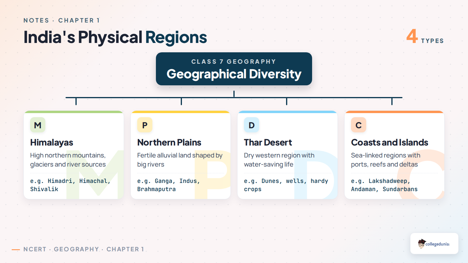
| Region | Main idea | Quick example |
|---|---|---|
| Himalayas | High northern mountains and river sources | Himadri, Himachal, Shivalik |
| Northern plains | Fertile alluvial land made by rivers | Ganga and Brahmaputra plains |
| Thar Desert | Dry western region with low rainfall | Dunes, wells, hardy crops |
| Coasts and islands | Sea-linked regions with ports and reefs | Lakshadweep, Andaman, Sundarbans |
Geographical Diversity of India Class 7 Video Recap
Source: Learning Notebook on YouTube
Himalayas, Plains and Desert in Class 7 Social Science
The Himalayas form a natural northern wall. They store snow and glaciers, feed rivers such as the Ganga, Indus and Brahmaputra, and support forests, hill towns and pilgrimage centres. The chapter also explains that the Himalayas formed when India pushed into Eurasia and the land folded upward.
- Himadri: the highest and most rugged range.
- Himachal: the lower range with many hill stations.
- Shivalik: the outer foothill range with forests and wildlife.
The Northern Plains are fertile because rivers deposit fine soil over time. The Thar Desert, in contrast, gets low rainfall, so people depend on water storage, local materials and crops that need less water.
Peninsular Plateau, Coasts and Islands Explained
The southern part of India is called a peninsula because water surrounds it on three sides. Much of this region is a plateau, which means raised land with a broad, fairly level top. The Western Ghats and Eastern Ghats mark important edges of this plateau.
India's coasts connect the country with fishing, ports, trade and lagoons. The east coast has large deltas made by the Mahanadi, Godavari, Krishna and Kaveri rivers. Lakshadweep is known for coral islands, while the Andaman and Nicobar Islands are important for marine life, history and sea-route safety.
How Geography Shapes Daily Life in India
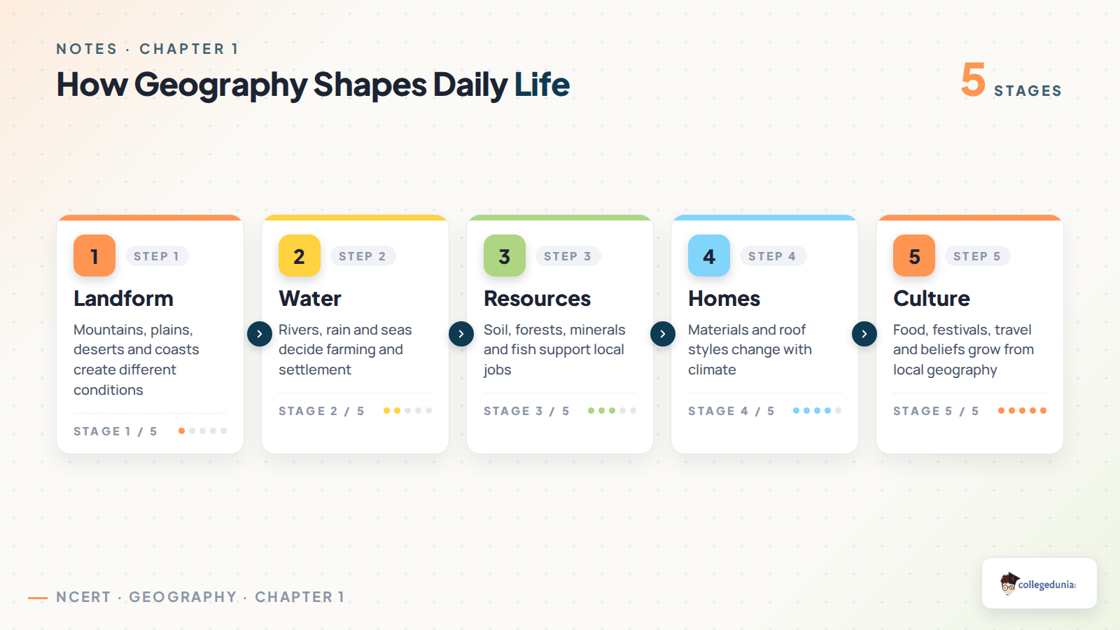
India's physical features shape everyday choices. In river plains, fertile soil and water support farming. In the desert, homes and food practices reflect heat and water scarcity. In coastal areas, fishing, ports and coconut belts become common parts of life.
- Climate: decides crops, clothing and roof styles.
- Water: affects settlement, farming and travel.
- Resources: forests, minerals, fish and soil support jobs.
- Culture: food, festivals and beliefs often grow from local geography.
Geographical Diversity of India Revision Table
Use this table for a fast recap before answering the textbook questions. It keeps each region, feature and life link in one place.
| Topic | Remember this | Answer clue |
|---|---|---|
| Subcontinent | India and its neighbours form a distinct part of Asia | Large size plus natural boundaries |
| Alluvial plain | Flat fertile land made by river deposits | Rivers carry soil from mountains |
| Delta | Land built when a river drops sediment near the sea | Sundarbans and east-coast deltas |
| Archipelago | A group of islands | Lakshadweep and Andaman-Nicobar |
Common Mistakes in Geographical Diversity of India Notes
Students often lose marks by writing region names without explaining their role. A strong answer always connects landform to life.
- Do not call the desert empty. It has settlements, water systems, crops and culture.
- Do not place Lakshadweep in the Bay of Bengal. It is in the Arabian Sea.
- Do not describe the Himalayas only as a wall. Add rivers, climate and culture.
- Do not write that all coasts are the same. The west and east coasts differ.
Class 7 Social Science Chapter 1 Cross Resource Links
Use the notes with the textbook PDF and question-answer resources for full chapter practice.
| Resource | Use it for | Link |
|---|---|---|
| NCERT Notes | Quick revision before class tests | Geographical Diversity of India Class 7 Notes |
| NCERT Book PDF | Official textbook reading | Class 7 Social Science Chapter 1 Book PDF |
| NCERT Solutions | Textbook question answers | Class 7 Social Science Chapter 1 Solutions |
| Handwritten Notes | One-shot revision | Class 7 Social Science Chapter 1 Handwritten Notes |
All Chapters in Class 7 Social Science Part 1 Notes
The same notes series helps students revise the full Exploring Society India and Beyond Part 1 textbook in chapter order.
| Chapter | Notes page |
|---|---|
| Chapter 1 | Geographical Diversity of India Notes |
| Chapter 2 | Understanding the Weather Notes |
| Chapter 3 | Climates of India Notes |
| Chapter 4 | New Beginnings Cities and States Notes |
Geographical Diversity of India Class 7 Notes FAQs
Ques. What is meant by geographical diversity of India?
Ans. Geographical diversity means India has many kinds of landforms and natural regions, such as mountains, plains, deserts, plateaus, coasts, islands, deltas and wet hills.
Ques. Why are the Himalayas important in Class 7 Social Science Chapter 1?
Ans. The Himalayas act as a northern barrier, feed major rivers, affect climate, support forests and settlements, and hold cultural value for many communities.
Ques. Why is southern India called a peninsular plateau?
Ans. It is called peninsular because water surrounds it on three sides. It is called a plateau because much of the land is raised and fairly level.
Ques. Which islands are mentioned in Geographical Diversity of India?
Ans. The chapter mentions Lakshadweep in the Arabian Sea and the Andaman and Nicobar Islands in the Bay of Bengal.



Comments