




The Class 12 Geography Chapter 8 International Trade textbook PDF is the official NCERT source for every board question on why nations trade, the basis of international trade, balance of trade, types of ports, and the concerns linked to globalisation. It carries about 4 to 6 marks in the CBSE board exam and is essential reading for CUET Geography and UPSC aspirants covering global trade patterns and gateways of international trade.
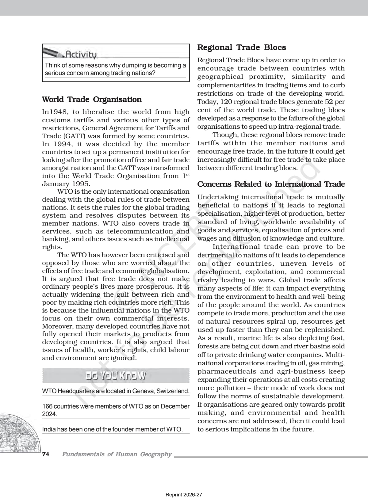
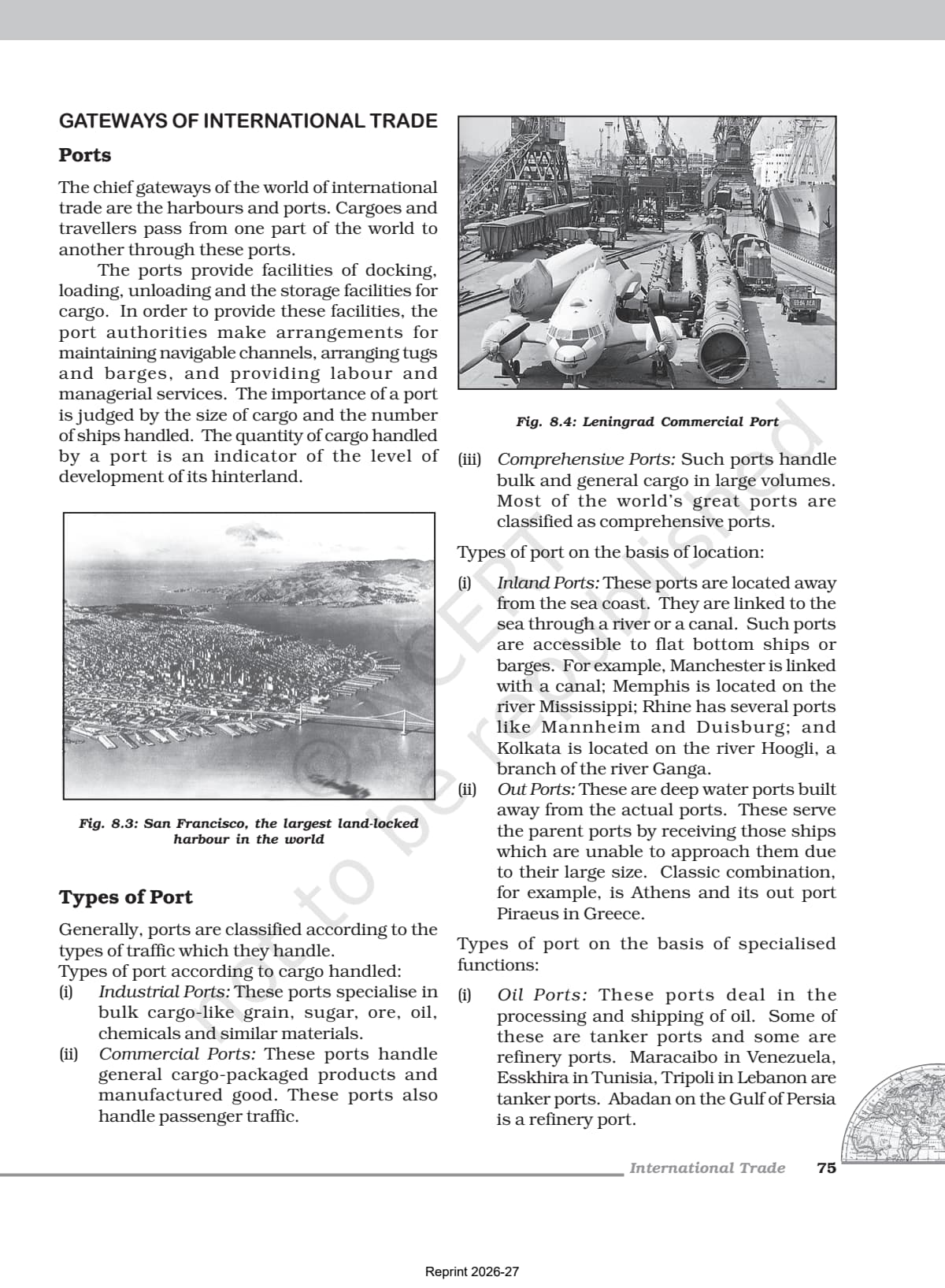
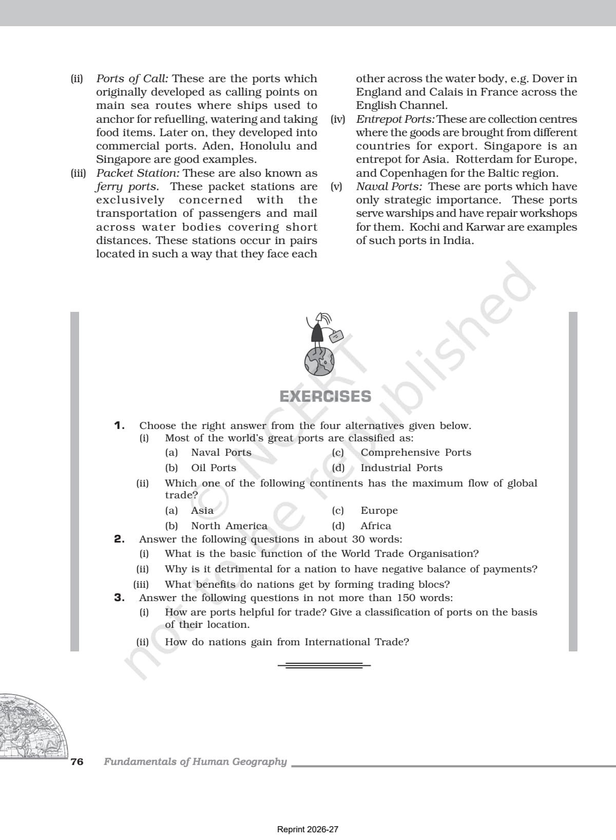
- Official NCERT Fundamentals of Human Geography Class 12 Chapter 8 PDF covering the history of international trade, its basis, balance of trade, types of international trade, ports and their classification, and concerns related to free trade and globalisation.
- 4-6 marks CBSE board-paper weightage for Chapter 8; the official textbook is the only source CBSE references when setting questions on international trade, ports, and dumping.
- Pair with the matching NCERT Solutions, Notes and Handwritten Notes for full chapter coverage.
Student Feedback
In a 2026 Collegedunia poll of 9,400 students, 80% said reading this NCERT PDF helped them answer questions on trade, ports, and the basis of trade more accurately than any guide book.
What This Chapter Covers in the NCERT Class 12 Book
The international trade class 12 geography NCERT chapter explains how countries exchange goods and services across national boundaries and why no country can produce everything it needs on its own. The official PDF is the source CBSE draws from when it sets questions on the basis of trade, balance of trade, types of ports, and dumping, so students preparing for the 2026-27 board paper should read it before any guide book. It moves from the history of trade (barter, Silk Route, globalisation) to comparative advantage, the five bases of trade, bilateral and multilateral trade, and finally the ports that act as gateways for all this movement.
Source: Humanities Wallah - Class 12th on YouTube
Topics in the Chapter (Section-Wise Map of the NCERT PDF)
The table below maps each sub-topic of the international trade class 12 PDF to its main concept and exam angle.
| Section | NCERT Sub-topic | Dominant Exam Concept |
|---|---|---|
| Intro | What is International Trade? | Exchange of goods and services across national boundaries; comparative advantage; voluntary exchange |
| History | History of International Trade | Silk Route; slave trade; Industrial Revolution; GATT and WTO; post-war trade liberalisation |
| 8.1 | Why Does International Trade Exist? | Specialisation; comparative advantage; complementarity; transferability; mutual benefit |
| 8.2 | Basis of International Trade | Five bases: national resources, population factors, stage of economic development, foreign investment, transport |
| 8.3 | Balance of Trade | Favourable vs unfavourable balance; link to balance of payments; exhaustion of financial reserves |
| 8.4 | Types of International Trade | Bilateral trade vs multilateral trade; Most Favoured Nation (MFN) status |
| 8.5 | Concerns: Free Trade and Dumping | Free trade / trade liberalisation; tariffs; dumping; impact on developing countries; sustainable development |
| 8.6 | Gateways: Ports and Their Types | By cargo: industrial, commercial, comprehensive; by location: inland, out ports; by function: oil, packet station, entrepot, naval |
Students preparing international trade class 12 notes should map each page to one of these rows. Section 8.2 on the basis of trade and Section 8.6 on ports together carry most board-paper questions from this chapter, because both are rich in defined categories and named examples.
Key Concepts From the NCERT Class 12 Geography Textbook
Reproducing NCERT phrasing in the board paper is the fastest route to full marks on theory questions. The four concept blocks below are taken directly from this chapter.
The Basis of International Trade
The textbook lists five bases. Difference in national resources is the most basic: geological structure, minerals, and climate give no two countries the same resource base. Population factors come next: cultural traditions and market size shape what is traded, and densely populated countries often consume most of their own output. The other three are the stage of economic development (agricultural vs industrialised nations trade different goods), the extent of foreign investment, and transport, which has widened trade from local to global.
Balance of Trade and Balance of Payments
Balance of trade records the volume of goods and services imported and exported: favourable when exports exceed imports, unfavourable when imports exceed exports. A negative balance means a country spends more than it earns, which slowly exhausts its financial reserves. Balance of payments is broader and covers all financial transactions between countries, not just goods. Both appear in short-answer questions.
Types of International Trade: Bilateral and Multilateral
Bilateral trade is between exactly two countries that agree to trade specified commodities. Multilateral trade involves many partners; a country may grant some of them Most Favoured Nation (MFN) status, treating them at least as well as its most favoured partner. Most modern trade is multilateral, governed by the World Trade Organisation (WTO), which replaced GATT.
Ports as Gateways of International Trade
Ports are the chief gateways of world trade, offering docking, loading, unloading, and storage. They are classified three ways. By cargo: industrial ports (bulk cargo like grain and oil), commercial ports (packaged goods and passengers), comprehensive ports (both). By location: inland ports linked to the sea by river or canal (Kolkata on the Hoogli), and out ports for large ships (Athens-Piraeus). By function: oil ports, ports of call, packet stations (Dover-Calais), entrepot ports (Singapore for Asia), and naval ports (Kochi, Karwar).
Previous Year Question Trends From This Chapter
This chapter has contributed 4 to 6 marks across recent board papers, mostly through MCQs, short-answer definitions, and one question on port types or trade concerns. Expect roughly the same distribution in 2026-27.
| Year | Marks | Question Types | Most Common Topic |
|---|---|---|---|
| 2025 | 5 | 1 MCQ + 1 short answer + 1 extended answer | Types of ports / basis of international trade |
| 2024 | 4 | 1 MCQ + 2 short answers | Balance of trade / dumping |
| 2023 | 5 | 1 MCQ + 1 short answer + 1 five-mark answer | Significance and basis of international trade |
| 2022 | 4 | 2 MCQs + 1 short answer | Types of trade (bilateral/multilateral) / port classification |
| 2020 | 6 | 1 long answer + 1 MCQ + 1 short answer | Ports as gateways; why international trade exists |
The most repeated question type asks students to classify ports with examples, or to explain the basis of international trade, both of which reward the textbook's named categories and specific examples.
Connecting This Chapter to the Rest of Fundamentals of Human Geography
This is the final chapter of the Fundamentals of Human Geography book and pulls together ideas from earlier chapters. Global trade patterns, port geography, and trade policy are recurring topics in CBSE, CUET, and UPSC Geography.
| Related Chapter | Concept Linking to Chapter 8 |
|---|---|
| Chapter 4: Primary Activities | Agricultural and mineral exports are primary goods traded in international markets; raw materials import-export discussed in trade basis |
| Chapter 5: Secondary Activities | Manufactured goods are the main exports of industrialised nations; trade shifts from primary to manufactured goods as economies develop |
| Chapter 6: Tertiary and Quaternary Activities | Trade and commerce introduced in Chapter 6 feed directly into global trade patterns; service trade is an extension of tertiary activity |
| Chapter 7: Transport and Communication | Transport modes (sea, air, road) are the physical infrastructure through which international trade actually moves; port geography builds on transport geography |
| Chapter 2: World Population | Population size and density affect internal trade vs external trade volumes, as explained in the population-factor basis of trade |
Quick Glossary From the NCERT Chapter
Students should be able to define each of these testable terms in a single line for one- and two-mark answers.
- International trade: The exchange of goods and services among countries across national boundaries.
- Comparative advantage: The principle that each country should specialise in the production of those commodities in which it has the greatest relative efficiency or lowest opportunity cost.
- Balance of trade: A record of the volume of goods and services imported and exported by a country; positive when exports exceed imports, negative when imports exceed exports.
- Bilateral trade: Trade conducted between two countries who enter into an agreement to exchange specified commodities with each other.
- Multilateral trade: Trade conducted with many trading countries; a single country trades with several partners and may grant MFN status to some.
- Most Favoured Nation (MFN): A trade status granted to a partner country ensuring it receives the same trade terms as the most favoured of the granting country's other partners.
- Dumping: The practice of selling a commodity in two countries at a price that differs for reasons not related to costs.
- Free trade (trade liberalisation): Opening up economies for trading by removing barriers like tariffs so goods and services from anywhere can compete with domestic products.
- Entrepot port: A collection centre where goods from different countries are brought together for export; Singapore is the textbook example for Asia.
- Inland port: A port located away from the sea coast, linked to the sea through a river or canal; Kolkata (on the Hoogli) is the textbook Indian example.
- Out port: A deep-water port built away from an actual port to receive large ships that cannot dock at the parent port; Athens and Piraeus are the textbook example.
- Packet station: A ferry port concerned exclusively with transportation of passengers and mail across short water bodies; Dover and Calais are the textbook example.
Also Explore Other Resources for Class 12 Geography Chapter 8
| Resource | Link |
|---|---|
| NCERT Solutions | Class 12 Geography Chapter 8 NCERT Solutions |
| Revision Notes | Class 12 Geography Chapter 8 Notes |
| Handwritten Notes | Class 12 Geography Chapter 8 Handwritten Notes |
| Subject Hub | Class 12 Geography All Chapters |
All Chapters: Class 12 Geography NCERT Book PDF (Fundamentals of Human Geography)
| Chapter | NCERT Book PDF |
|---|---|
| Chapter 1 | Human Geography: Nature and Scope NCERT Book PDF |
| Chapter 2 | The World Population: Distribution, Density and Growth NCERT Book PDF |
| Chapter 3 | Human Development NCERT Book PDF |
| Chapter 4 | Primary Activities NCERT Book PDF |
| Chapter 5 | Secondary Activities NCERT Book PDF |
| Chapter 6 | Tertiary and Quaternary Activities NCERT Book PDF |
| Chapter 7 | Transport and Communication NCERT Book PDF |
| Chapter 8 | International Trade NCERT Book PDF (You are here) |
Frequently Asked Questions on Class 12 Geography Chapter 8 NCERT Book PDF
Ques. Where can students download the official NCERT Class 12 Geography Chapter 8 PDF?
Ans. Students can download the official international trade class 12 geography NCERT book PDF directly from the download card at the top of this page. The PDF is the single-chapter file from the Fundamentals of Human Geography textbook, aligned to the 2026-27 CBSE syllabus.
Ques. What is international trade according to the NCERT Class 12 Geography textbook?
Ans. According to the NCERT textbook, international trade is the exchange of goods and services among countries across national boundaries. Countries need to trade to obtain commodities they cannot produce themselves or can purchase elsewhere at a lower price. It is based on the principle of comparative advantage, complementarity, and transferability of goods and services, and should be mutually beneficial to the trading partners.
Ques. What are the five bases of international trade according to NCERT Class 12 Geography Chapter 8?
Ans. The five bases of international trade listed in the NCERT textbook are: (1) Difference in national resources - geological structure, mineral resources, and climate create different resource bases; (2) Population factors - cultural traditions, size of population, and standard of living affect the type and volume of goods traded; (3) Stage of economic development - agricultural nations export agro products while industrialised nations export machinery and finished goods; (4) Extent of foreign investment - capital flows into developing countries to develop mining, oil drilling, and plantation agriculture, boosting trade volumes; (5) Transport - expansion of rail, ocean, and air transport has enabled spatial expansion of trade.
Ques. What is the difference between balance of trade and balance of payments?
Ans. Balance of trade records the volume of goods and services imported and exported by a country. It is positive (favourable) when exports exceed imports and negative (unfavourable) when imports exceed exports. Balance of payments is a broader concept that covers all financial transactions between a country and the rest of the world, including trade, services, investment income, and transfers. A negative balance of trade can lead to exhaustion of a country's financial reserves over time.
Ques. What is the difference between bilateral trade and multilateral trade?
Ans. Bilateral trade is conducted between exactly two countries, who enter into an agreement to trade specified commodities with each other - for example, country A agrees to export raw materials to country B in exchange for specified finished goods. Multilateral trade is conducted with many trading countries; a single country trades with several others simultaneously and may grant some of them Most Favoured Nation (MFN) status. Most modern international trade is multilateral, governed by the World Trade Organisation (WTO).
Ques. What is dumping according to the NCERT Class 12 Geography textbook?
Ans. The NCERT textbook defines dumping as the practice of selling a commodity in two countries at a price that differs for reasons not related to costs. Dumped goods are typically sold at cheaper prices in the importing country, which can harm domestic producers in that country. Countries need to be cautious about dumped goods, as they can undercut local manufacturing and distort markets even under free trade conditions.
Ques. What are comprehensive ports and why are most of the world's great ports classified as such?
Ans. Comprehensive ports handle both bulk cargo and general cargo in large volumes. Most of the world's great ports are classified as comprehensive because modern trade involves a mix of industrial bulk goods (grains, oil, minerals) and commercial packaged and manufactured goods. Industrial ports specialise only in bulk cargo; commercial ports handle only general cargo and passengers. A comprehensive port can handle all types efficiently, making it suitable for the diverse trade needs of major economies.
Ques. What is an entrepot port and which countries have the most famous examples?
Ans. An entrepot port is a collection centre where goods from different countries are brought together for further export. These ports act as hubs in regional trade networks. The NCERT textbook gives three examples: Singapore as the entrepot for Asia, Rotterdam as the entrepot for Europe, and Copenhagen as the entrepot for the Baltic region. Entrepot ports benefit from their strategic geographical location at the intersection of major shipping routes.
Ques. What is free trade and what are the concerns about it for developing countries?
Ans. Free trade (trade liberalisation) is the opening up of economies for trading by reducing barriers like tariffs, so goods and services from everywhere can compete with domestic products. The NCERT textbook notes three concerns for developing countries: free trade may not provide an equal playing field if conditions are unfavourable; it can allow rich countries to keep their own markets protected while opening developing country markets; and dumped goods at artificially cheap prices can harm domestic producers. The chapter also flags the environmental cost of rising production and resource use that accompanies global trade expansion.
Ques. What is the significance of the Silk Route in the history of international trade?
Ans. The Silk Route is one of the earliest examples of long-distance international trade. It was a 6,000 km route connecting Rome to China, along which traders transported Chinese silk, Roman wool, precious metals, and high-value commodities through intermediate points in India, Persia, and Central Asia. The Silk Route demonstrates that even before modern transport, nations traded high-value goods over very long distances, taking on the considerable risks of ancient travel to gain access to commodities unavailable at home.
Ques. What are inland ports and out ports according to the NCERT textbook?
Ans. Inland ports are located away from the sea coast and are linked to the sea through a river or canal, accessible to flat-bottomed ships or barges. Examples from the NCERT include Manchester (linked by canal), Memphis on the Mississippi, Kolkata on the Hoogli, and Mannheim and Duisburg on the Rhine. Out ports are deep-water ports built away from an actual (parent) port to receive large ships that cannot enter the shallower parent port because of their size. The classic textbook example is Athens and its out port Piraeus in Greece.
Ques. Is the Class 12 Geography syllabus changing for 2026-27?
Ans. No major changes have been announced. The Fundamentals of Human Geography textbook chapter structure remains the same for 2026-27, and the official NCERT PDF available on this page is aligned to the 2026-27 CBSE syllabus. CBSE marking schemes continue to reward textbook phrasing in theory questions and specific named examples from the NCERT text in extended answers.
Ques. What is the best order to use the NCERT PDF, Notes, and Solutions for Class 12 Geography Chapter 8?
Ans. Read the NCERT PDF cold first, marking unfamiliar terms like balance of trade, dumping, entrepot port, and MFN status. Then open the Class 12 Geography Chapter 8 Notes alongside the PDF and draw a classification tree of the port types. Attempt all exercise questions and verify them against the NCERT Solutions. Use the handwritten notes for last-mile revision the night before the exam.
Ques. How does CUET test Class 12 Geography Chapter 8 International Trade?
Ans. CUET Geography tests this chapter through MCQs on definitions (international trade, bilateral trade, multilateral trade, MFN status, dumping, entrepot port, inland port, balance of trade), the basis of international trade, port classifications with examples, and the role of WTO. All questions are drawn from the NCERT textbook, so reading the official PDF is the most effective preparation for both CUET 2026-27 and the CBSE board exam.



Comments