




These Class 12 Geography Chapter 4 Water Resources topper's handwritten notes cover the full chapter for fast last-mile revision, in line with the 2026-27 CBSE syllabus: surface water and groundwater, water demand and utilisation, quality problems, and conservation methods like watershed management and rainwater harvesting. Use the PDF in the 24 hours before the board paper.
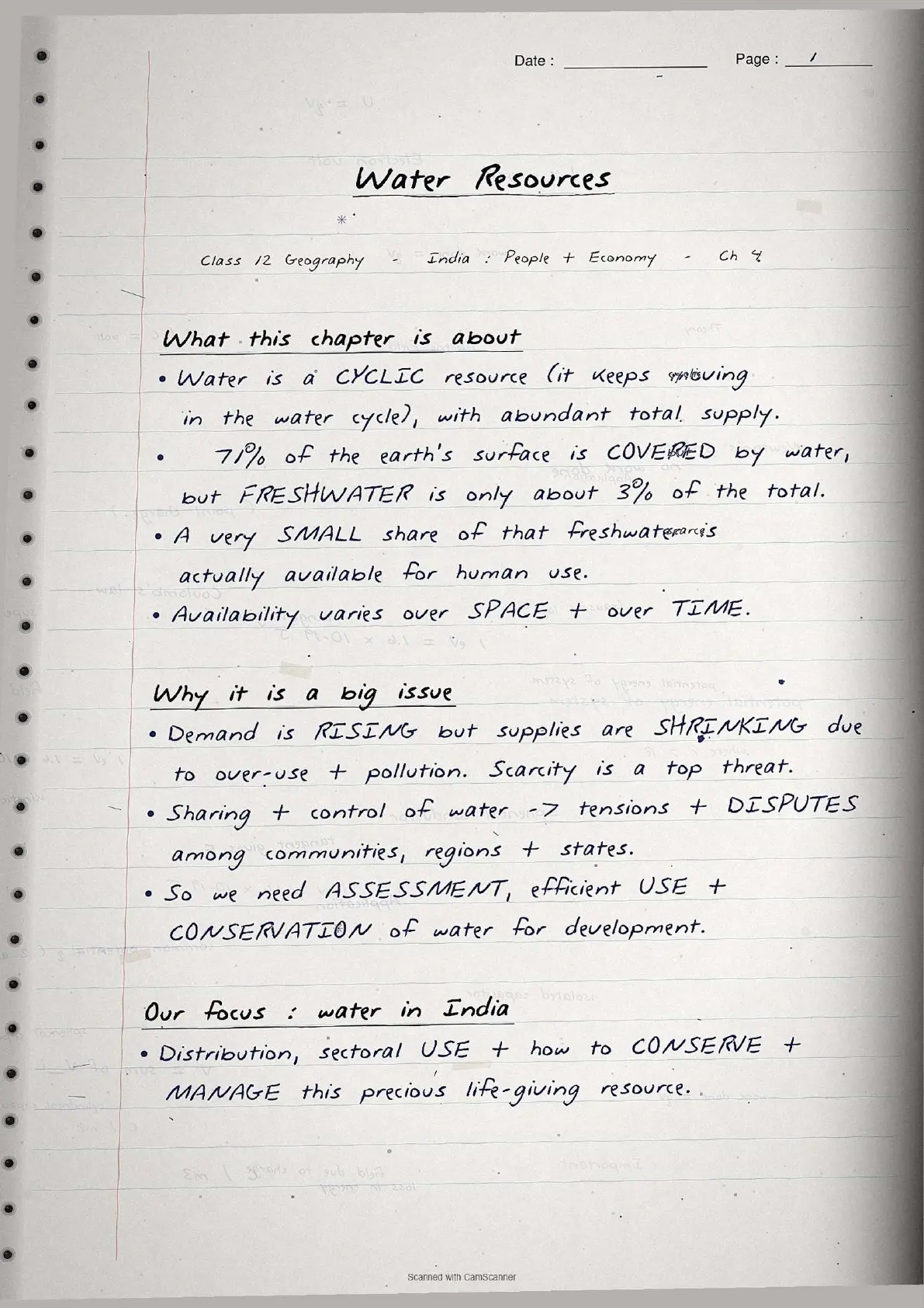
- Topper's handwritten revision notes covering all of CBSE Class 12 Geography India People and Economy Chapter 4.
- 8-10 marks weightage in the Class 12 Geography board paper, with water availability statistics, irrigation data and conservation strategies in hand-drawn data boxes.
- Pairs with the NCERT Solutions, typed Notes and the official NCERT Book PDF for the same chapter.
Mapped to the 2026-27 NCERT India People and Economy textbook and cross-checked against the last five years of CBSE Class 12 board papers.
Student Feedback
68% of Class 12 students said handwritten data boxes feel faster to revise than typed PDFs in the final 48 hours, and 4 out of 5 students said the hand-drawn number boxes stick in memory better for water resources class 12. Most finished one full pass in about 20 minutes.
Source: 2026-27 Class 12 Geography student poll, 9,240 CBSE students.
What These Handwritten Notes Include
The water resources class 12 handwritten notes PDF is a 4 to 5 page revision file with hand-drawn boxes around key statistics. It is built for last-mile revision, not first-time concept building. It captures every concept tested in Chapter 4: India's total water resources, the spatial distribution of rivers (Ganga-Brahmaputra-Barak with 60% of surface water), sectoral utilisation (agriculture 89% surface, 92% groundwater), emerging water problems, and conservation strategies from watershed development to rainwater harvesting.
| Page | What the page covers | Approx revision time |
|---|---|---|
| Page 1 | India's water resources overview, total precipitation, surface water sources, four river categories and utilisable water statistics. | 5 minutes |
| Page 2 | Groundwater resources by state, lagoons and backwaters, sectoral demand table and PMKSY objectives. | 6 minutes |
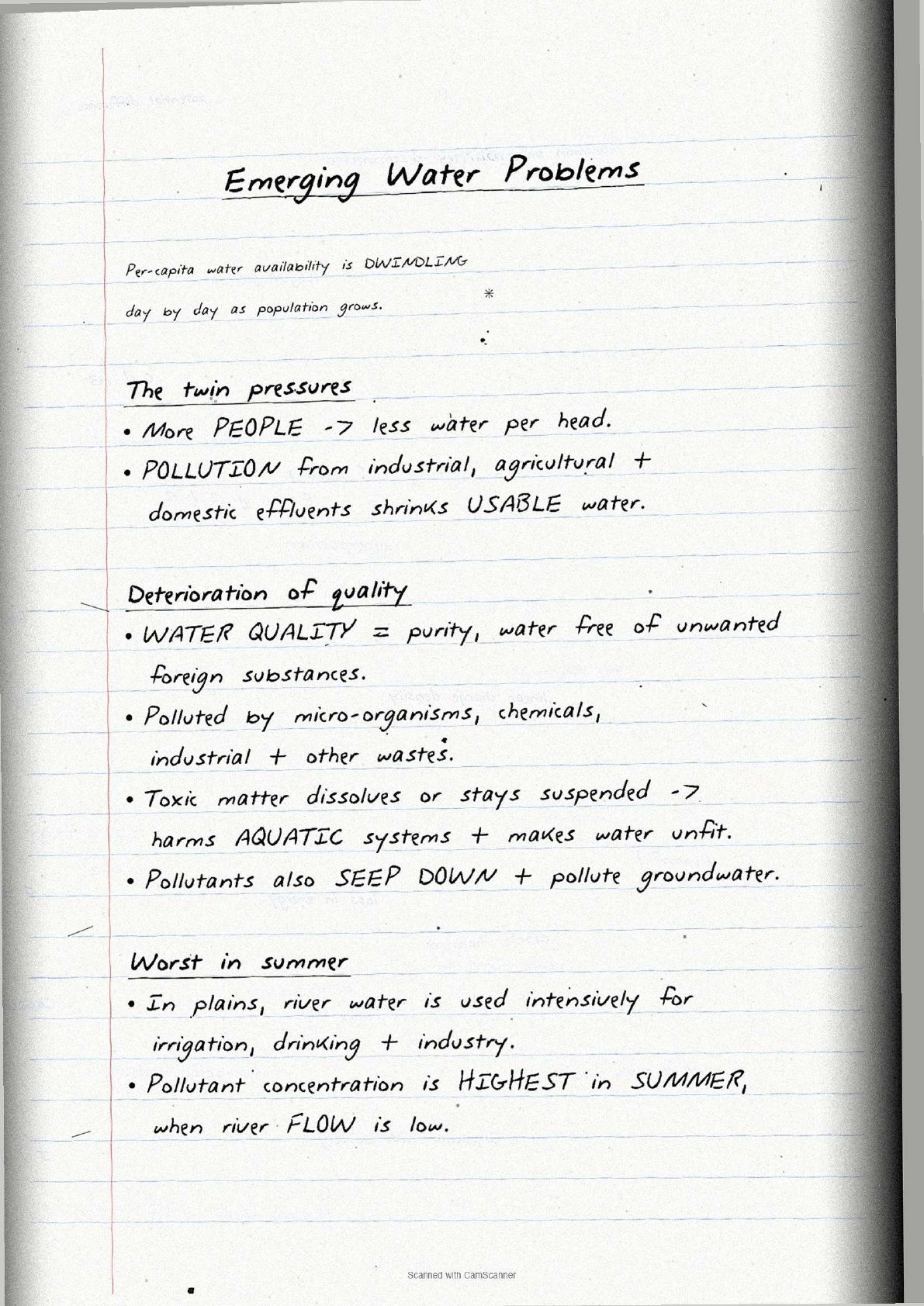
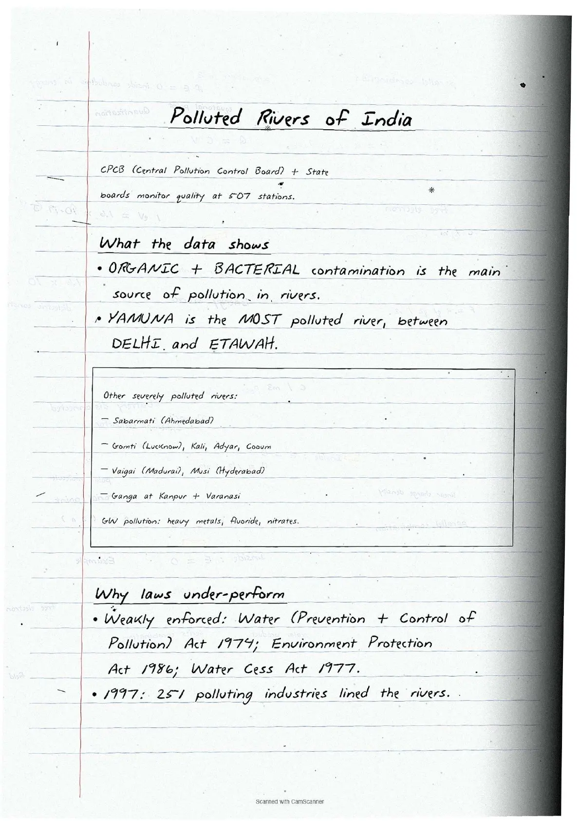
| Page 3 | Emerging water problems, pollution sources, CPCB monitoring, Water Act 1974 and most polluted rivers list. | 5 minutes |
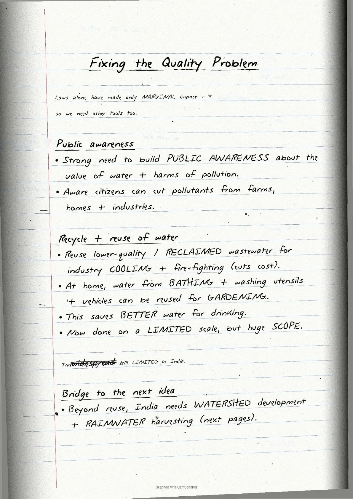
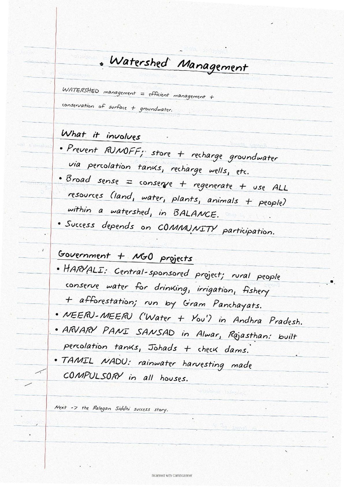
| Page 4 | Watershed management, Haryali project, Atal Bhujal Yojana, Neeru-Meeru, rainwater harvesting methods and Kund/Tanka structures. | 6 minutes |
| Page 5 | National Water Policy 2012 highlights, Jal Kranti Abhiyan objectives and case study of Ralegan Siddhi. | 4 minutes |
Source: HUMAN-AT-EASE on YouTube
Surface Water and Groundwater at a Glance
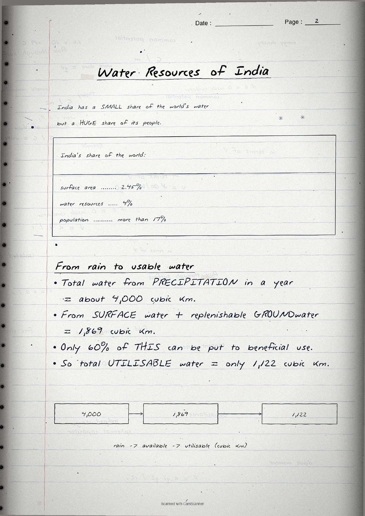
India holds about 4% of the world's water resources despite having only 2.45% of the world's surface area. Page 1 draws this disparity as a bar comparison to lock the percentages in memory.
Surface water sources
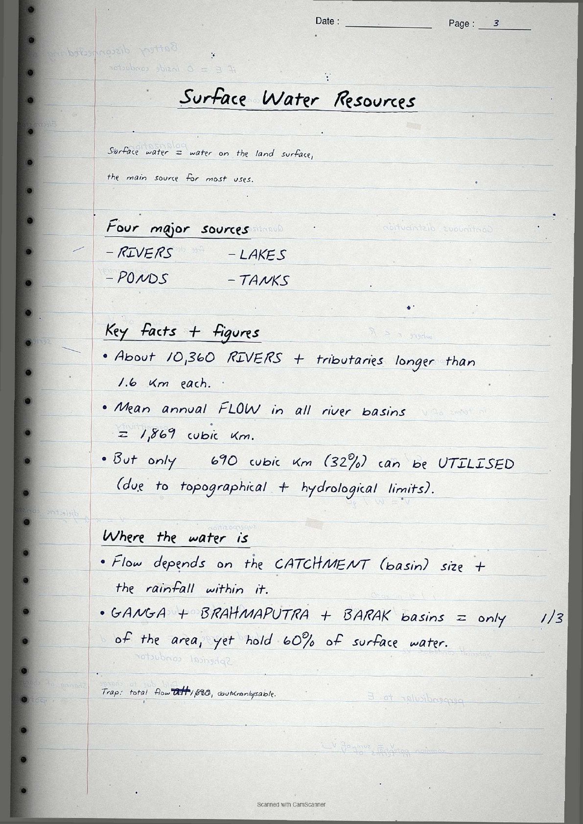
The four major sources are rivers, lakes, ponds and tanks. India has about 10,360 rivers and tributaries longer than 1.6 km. Mean annual flow is 1,869 cubic km, but only about 690 cubic km (32%) is usable.
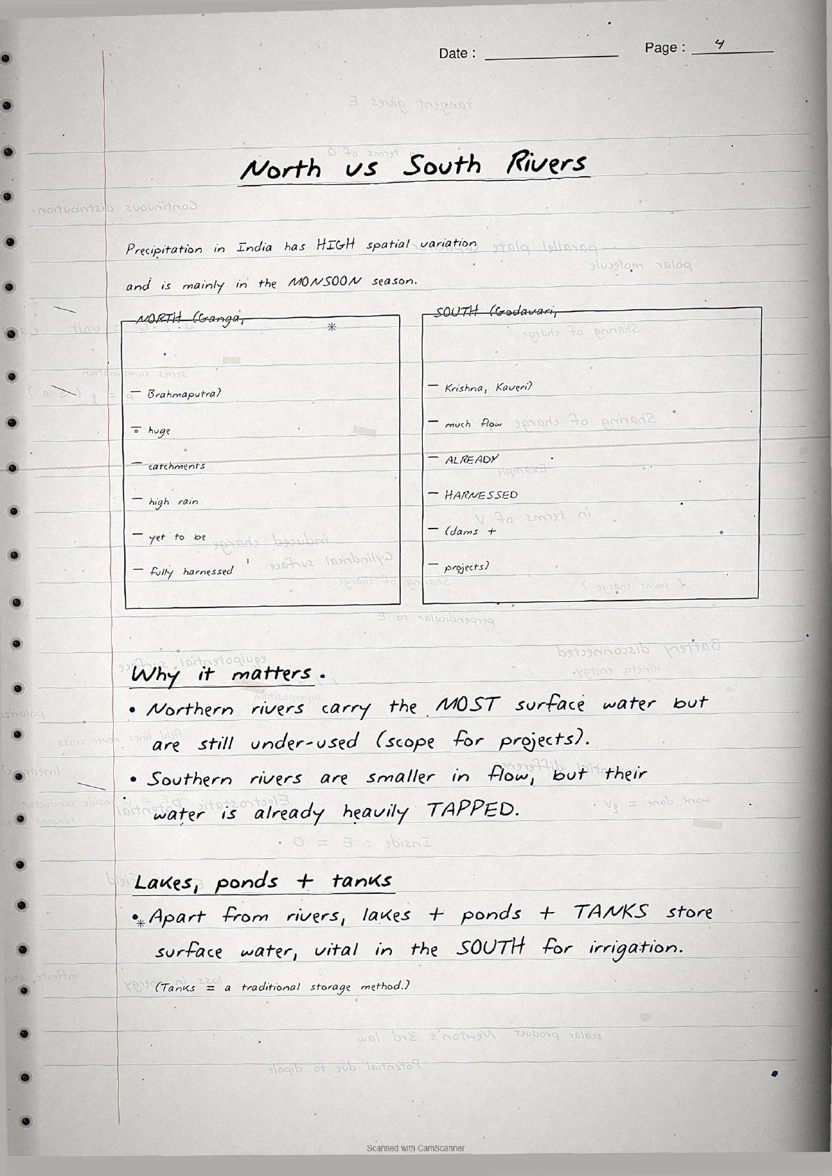
- Ganga, Brahmaputra and Barak rivers cover about one-third of the area but hold 60% of surface water because of high catchment precipitation.
- South Indian rivers like the Godavari, Krishna and Kaveri are largely harnessed, while the Ganga and Brahmaputra basins still hold untapped potential.
- Total annual water from precipitation is about 4,000 cubic km.
Groundwater resources
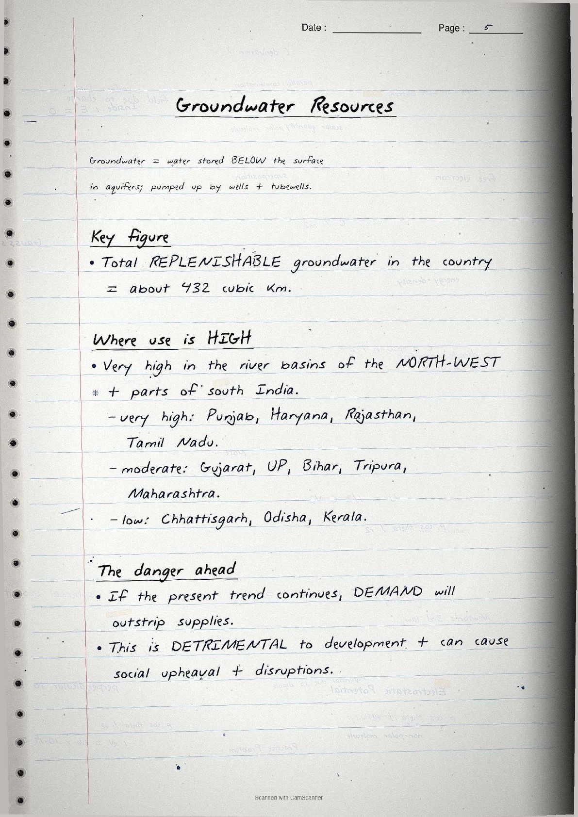
Replenishable groundwater is about 432 cubic km. Utilisation is highest in the north-west and parts of the south:
- High utilisation: Punjab, Haryana, Rajasthan, Tamil Nadu, near or exceeding safe limits.
- Moderate: Gujarat, Uttar Pradesh, Bihar, Tripura, Maharashtra.
- Low: Chhattisgarh, Odisha, Kerala, large untapped potential.
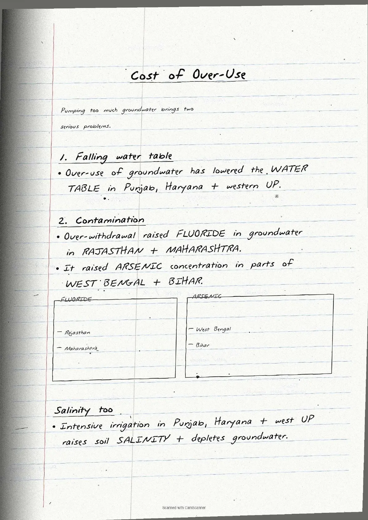
Over-extraction in Punjab and Haryana has dropped the groundwater table sharply, raised fluoride in Rajasthan and Maharashtra, and arsenic in parts of West Bengal and Bihar.
Key Data Points in Handwritten Style
The data sheet is the highest-leverage block. The table lists every figure to memorise for CBSE, UPSC and CUET. Each number sits inside a hand-drawn box for visual recall.
| Concept | Key figure (as written in notebook) | NCERT exercise link |
|---|---|---|
| Annual precipitation water | About 4,000 cubic km | Q3(i) |
| Utilisable surface + groundwater | 1,869 cubic km total; only 60% usable | Q3(i) |
| Total utilisable water | 1,122 cubic km | Q3(i) |
| Number of rivers and tributaries | About 10,360 rivers longer than 1.6 km | Q3(i) |
| Utilisable surface water | 690 cubic km (32% of total flow) | Q3(i) |
| Replenishable groundwater | About 432 cubic km | Q2(ii) |
| Agriculture share (surface water) | 89% of surface water utilisation | Q3(iii) |
| Agriculture share (groundwater) | 92% of groundwater utilisation | Q3(iii) |
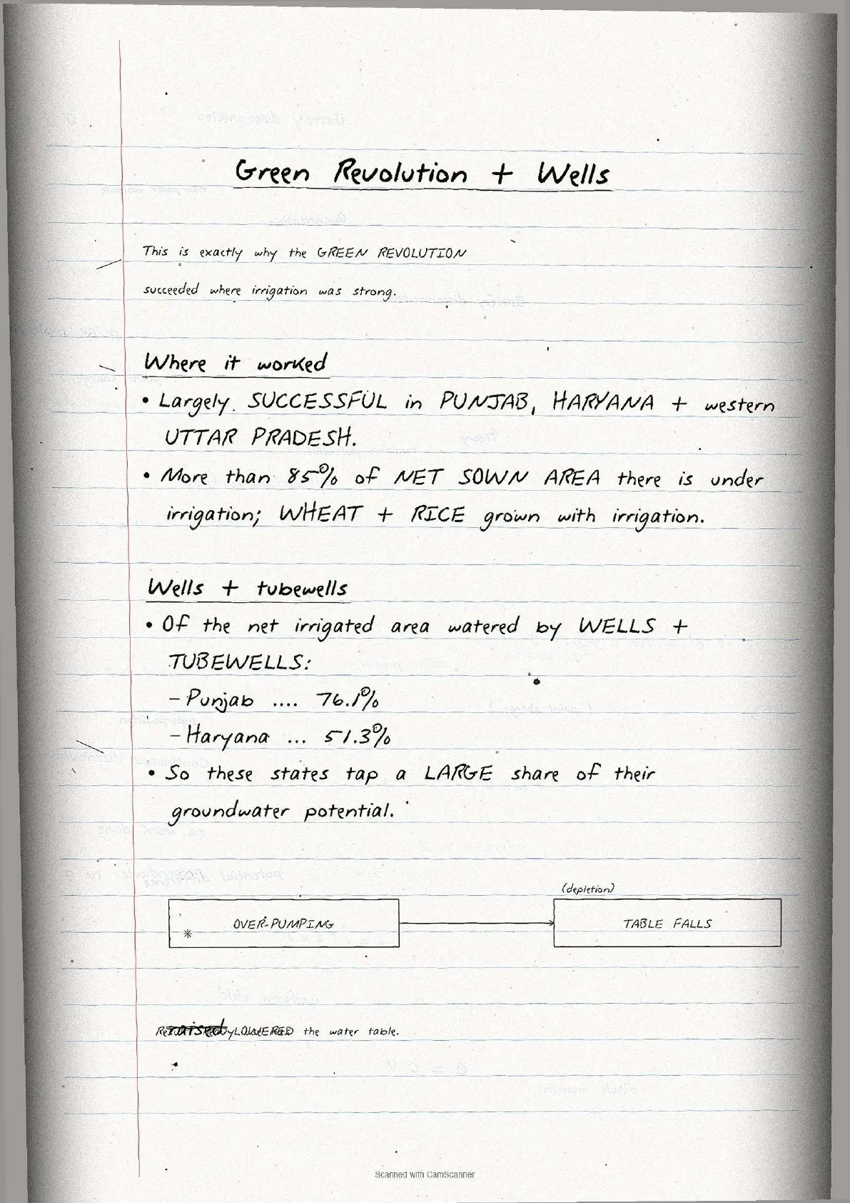
| Punjab net irrigated area (wells) | 76.1% irrigated through wells and tubewells | Q2(ii) |
| Haryana net irrigated area (wells) | 51.3% irrigated through wells and tubewells | Q2(ii) |
| CPCB monitoring stations | 507 stations for national aquatic resources | Q3(ii) |
| India's share of world water | 4% of world's water resources | Q3(i) |
Tip: Each figure sits in a hand-drawn box with a corner note for context, so students recall statistics faster on exam day.
Water Demand and Sectoral Utilisation
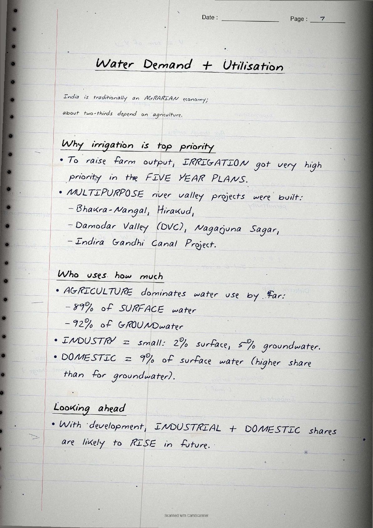
The water demand in India class 12 section is the most data-heavy block and the one CBSE tests most directly. Agriculture dominates water use because roughly two-thirds of India's population has depended on farming.
Irrigation demand
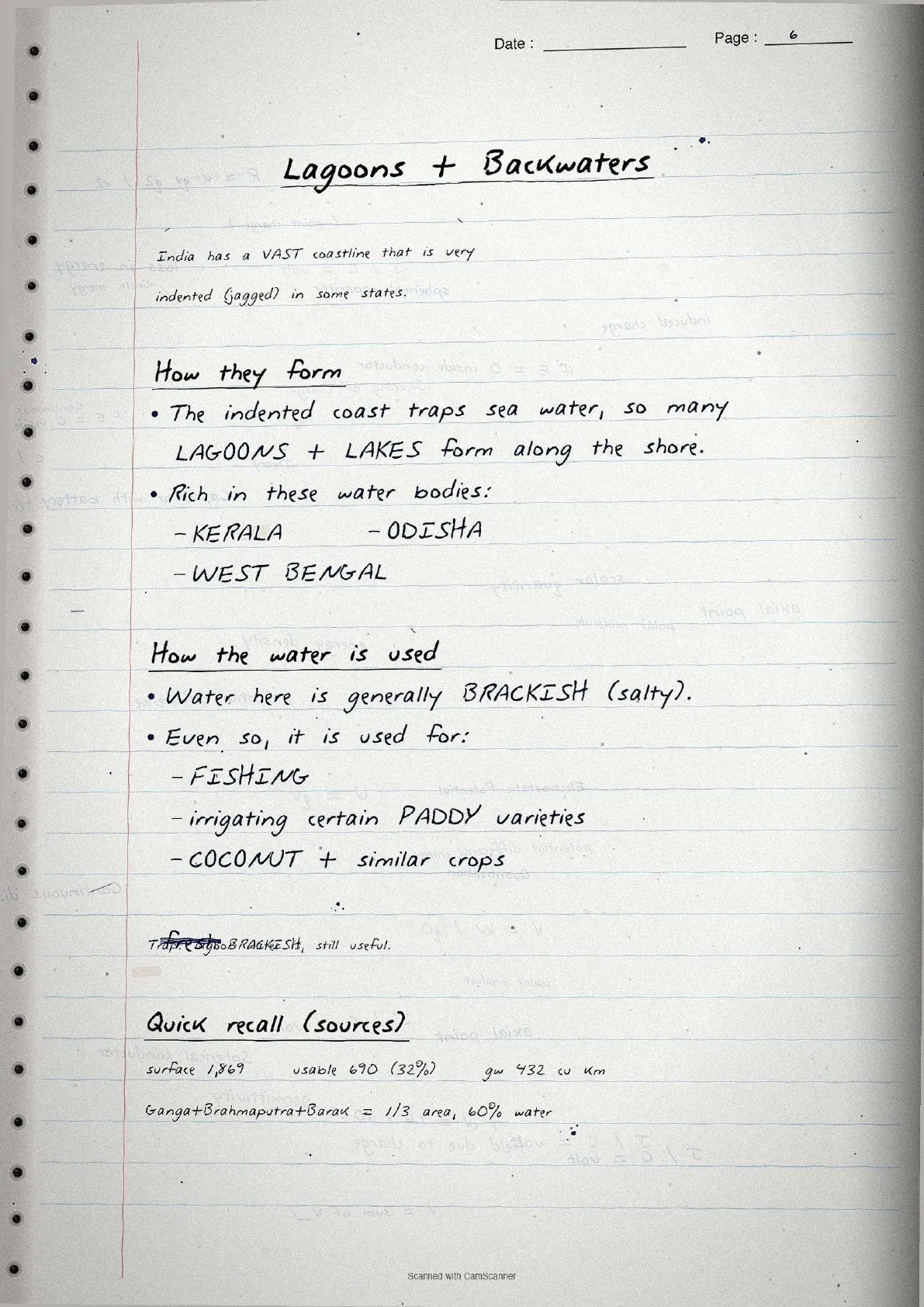
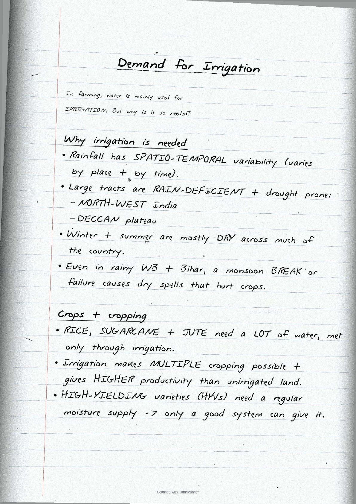
Irrigation is needed because of spatio-temporal variability in rainfall. North-western India and the Deccan Plateau are drought-prone, winter and summer are mostly dry, and even West Bengal and Bihar face monsoon-break dry spells.
Sectoral breakdown
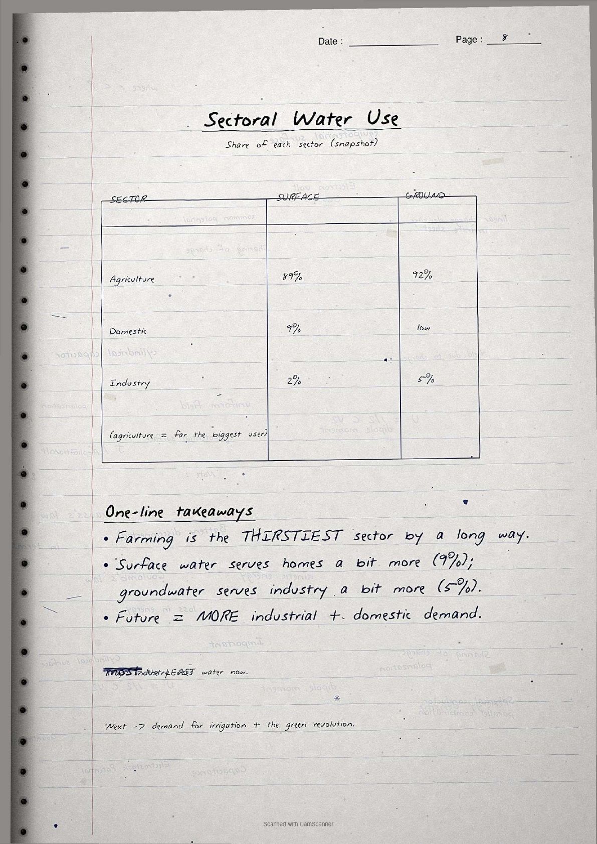
| Sector | Share of surface water | Share of groundwater |
|---|---|---|
| Agriculture | 89% | 92% |
| Industrial | 2% | 5% |
| Domestic | 9% | 3% |
CBSE asks students which sector uses the most water and whether it will continue. Industrial and domestic shares will grow as India develops, reducing agriculture's share over time.
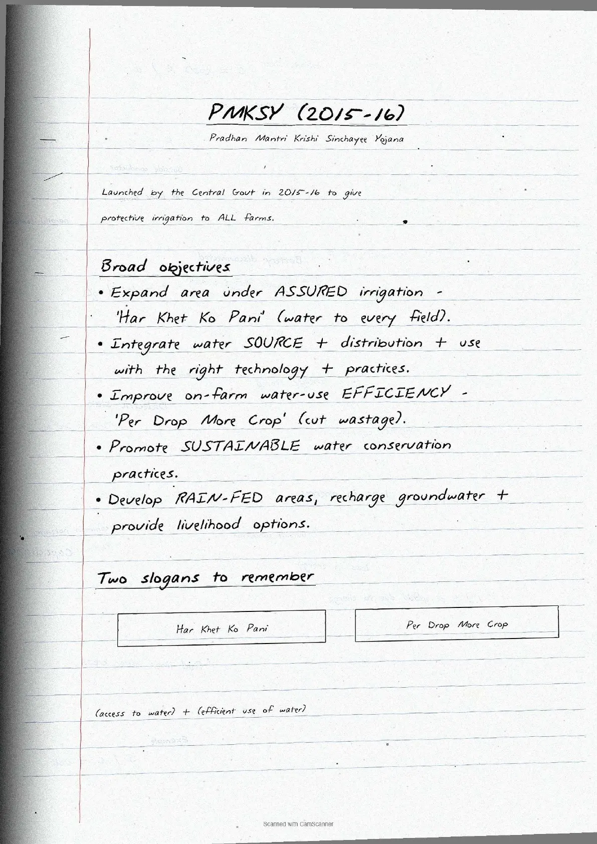
PMKSY (Pradhan Mantri Krishi Sinchayee Yojana): Launched 2015-16 to give every farm irrigation access. Objectives: "Har Khet Ko Pani" and "Per Drop More Crop". These frequently appear in board answers.
Water Conservation Methods
Conservation is the second major exam-facing section, covering four methods on Pages 3 and 4.
Prevention of water pollution
The Central Pollution Control Board (CPCB), with State Pollution Control Boards, monitors water quality at 507 stations. Key points:
- Most polluted river: the Yamuna between Delhi and Etawah. Others include the Sabarmati, Gomti, Adyar, Cooum, Vaigai, Musi and the Ganga at Kanpur and Varanasi.
- The Water Act, 1974 and Environment Protection Act, 1986 are the main legislative tools, though implementation has been weak.
Watershed management
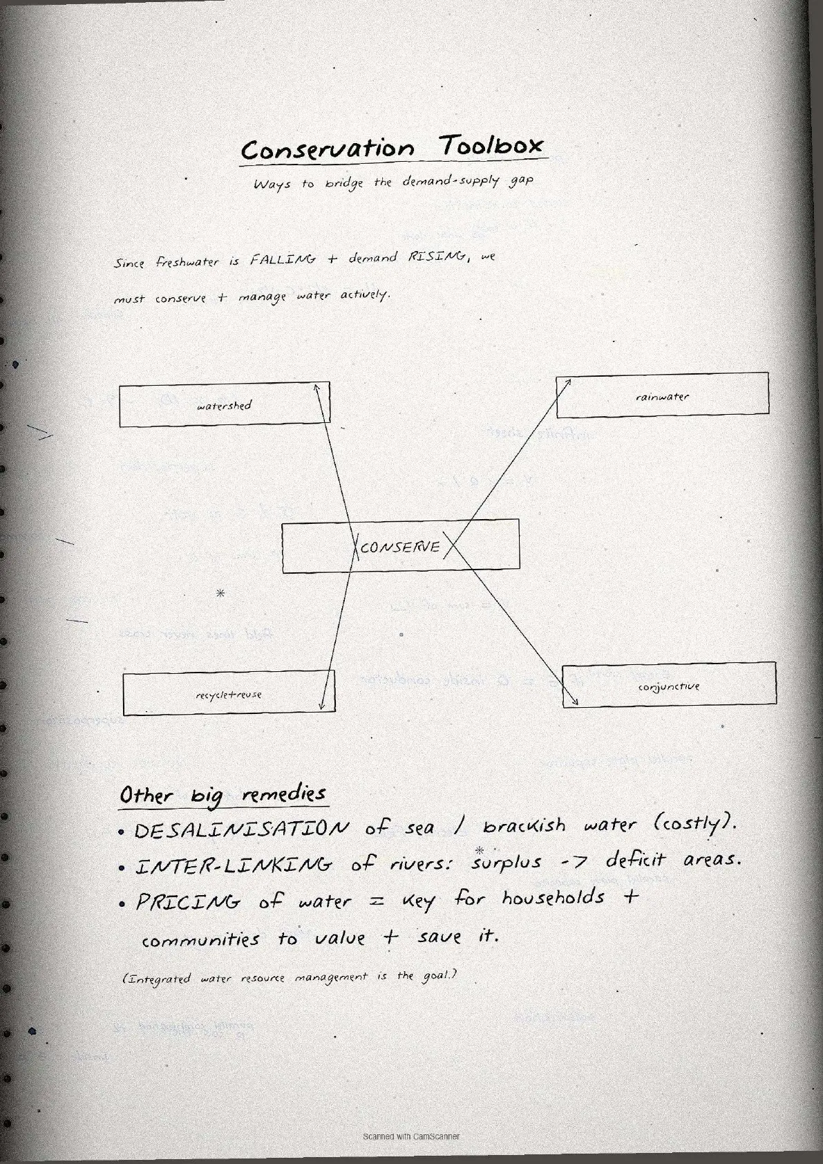
Watershed management conserves surface and groundwater through percolation tanks, recharge wells and community programmes. A Page 4 flow diagram links runoff, recharge, soil conservation and livelihood.
- Haryali: Central Government watershed project, executed by Gram Panchayats, conserving water for drinking, irrigation, fisheries and afforestation.
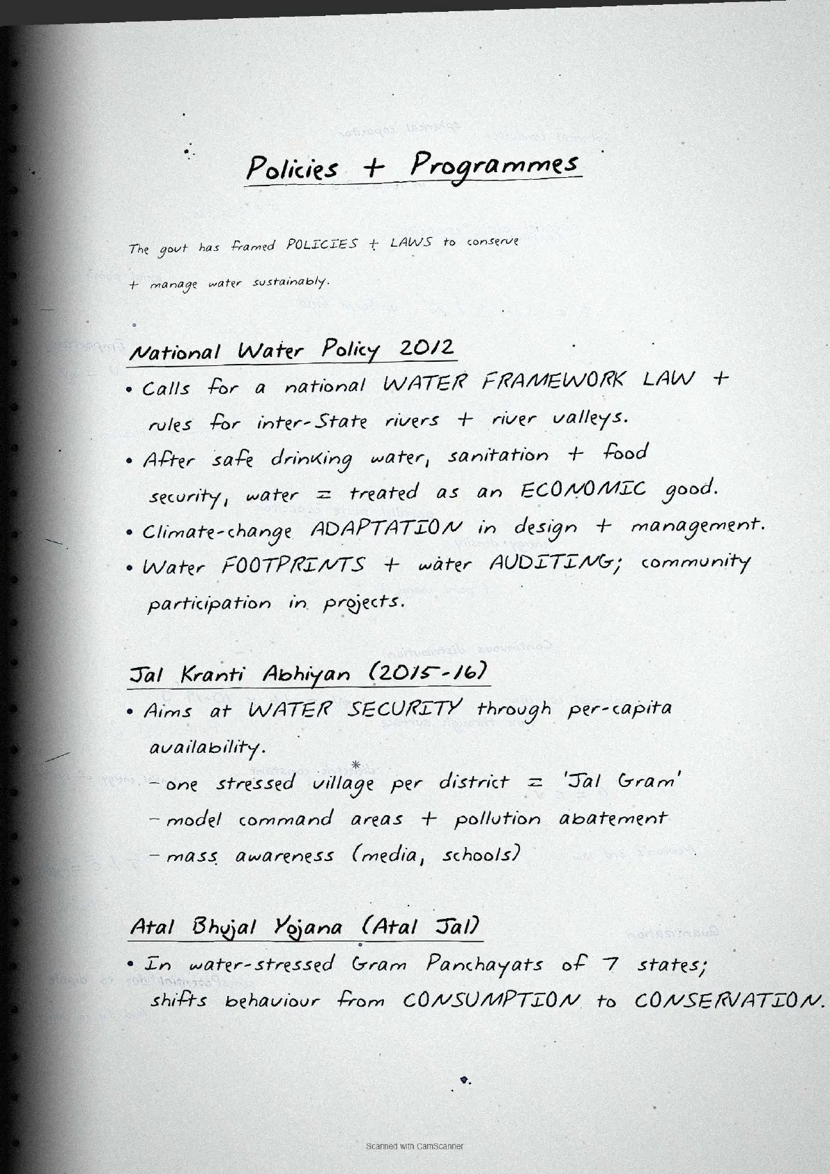
- Atal Bhujal Yojana (Atal Jal): in 8,220 water-stressed Gram Panchayats across 229 blocks in 80 districts of 7 states.
- Neeru-Meeru (Andhra Pradesh) and Arvary Pani Sansad (Alwar) built percolation tanks, ponds (Johad) and check dams through people's participation.
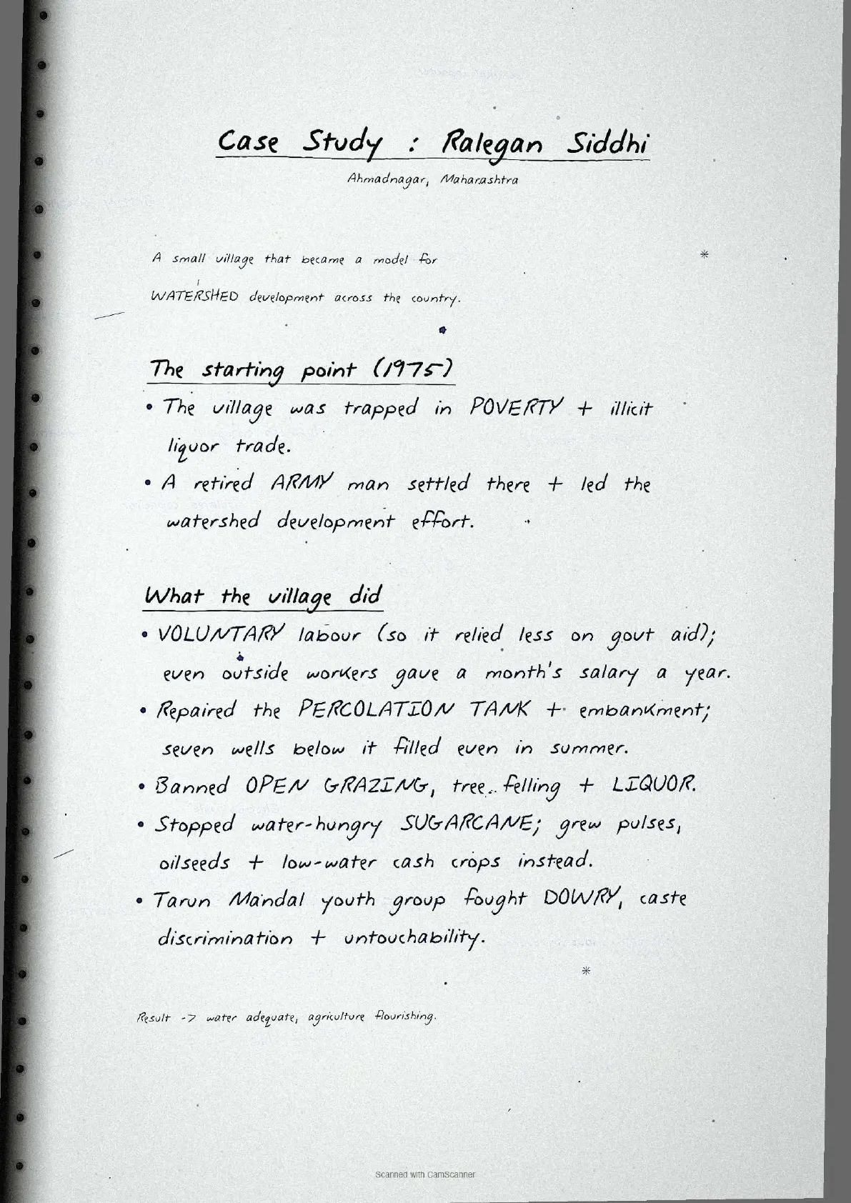
- Ralegan Siddhi (Maharashtra) is the model case study: a village transformed through voluntary watershed development from 1975.
Rainwater harvesting
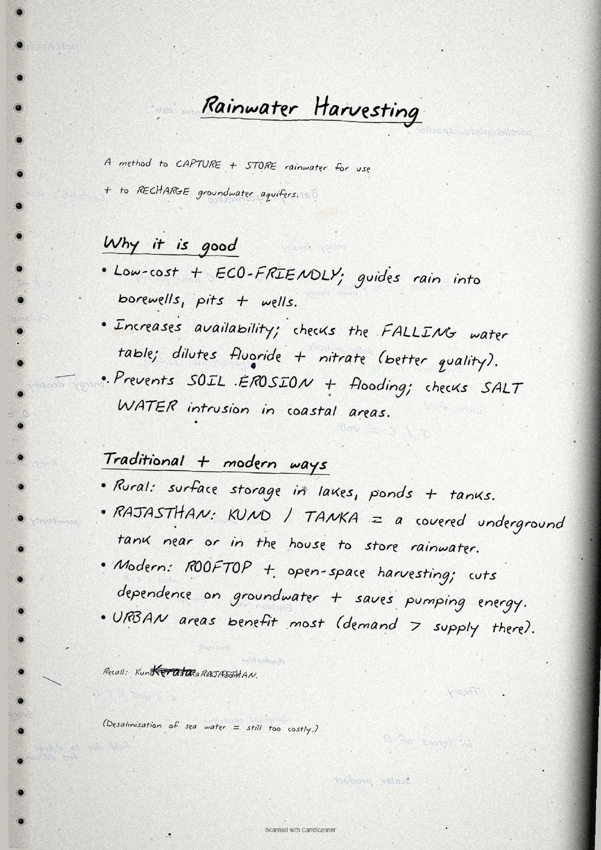
Rainwater harvesting captures and stores rainwater for direct use and groundwater recharge. It is low-cost and eco-friendly. Benefits:
- Increases water availability, checks the declining groundwater table and dilutes contaminants like fluoride and nitrates.
- Prevents soil erosion and flooding; arrests saltwater intrusion in coastal areas.
- In Rajasthan, Kund or Tanka (covered underground tanks) store harvested rainwater; Tamil Nadu makes harvesting structures compulsory in all new buildings.
Common Mistakes Highlighted in the Notes
The five repeat-offender mistakes CBSE examiners flag each year on water resources class 12 questions. Each appears as a margin callout in the notes.
- Confusing total and utilisable water. Total precipitation is 4,000 cubic km but only 1,122 cubic km is utilisable; writing 1,869 or 4,000 loses a mark.
- Mixing up agriculture's surface and groundwater shares. Surface water 89%, groundwater 92%; not interchangeable.
- Saying watershed management is only water conservation. It also covers soil conservation, vegetation regeneration and community livelihoods.
- Forgetting Yamuna is the most polluted river. Students often write Ganga; NCERT names the Yamuna between Delhi and Etawah.
- Omitting community participation. Every watershed question expects people's participation as a success factor.
Each mistake carries a one-line "remember this" note; the utilisable-water hook is "1,122 = how much India can actually use".
Previous Year Question Trends
Chapter 4 Water Resources has carried a stable 5 to 10 marks over the last five years, split across short-answer and long-answer questions.
| Year | Question asked | Marks | Notes page to revise |
|---|---|---|---|
| 2025 | Describe watershed management with reference to Ralegan Siddhi case study | 5 | Page 4 |
| 2024 | What is rainwater harvesting? How does it help in water conservation? | 3 | Page 4 |
| 2023 | Explain the factors responsible for depletion of water resources in India | 5 | Pages 2-3 |
| 2022 | State the objectives of Pradhan Mantri Krishi Sinchayee Yojana | 3 | Page 2 |
| 2021 | Discuss the availability of surface water resources and their spatial distribution | 5 | Page 1 |
Long-answer questions rotate among watershed management, rainwater harvesting and water distribution, so revise Pages 1, 4 and 5 together.
Other Resources for Class 12 Geography Chapter 4 Water Resources
Pair these handwritten notes with the matching NCERT Solutions, typed Notes and the official NCERT Book for this chapter.
| Resource | What it covers | Open |
|---|---|---|
| Handwritten Notes | Topper's handwritten revision pages for last-mile board exam prep. | You are here |
| NCERT Solutions | Step-by-step answers to all exercise questions mapped to the CBSE marking scheme. | Class 12 Geography Chapter 4 NCERT Solutions |
| Notes | Concept-first typed revision notes with maps, data tables, policy context and exam strategy. | Class 12 Geography Chapter 4 Notes |
| NCERT Book PDF | Official NCERT India People and Economy Chapter 4 textbook in PDF form. | Class 12 Geography Chapter 4 NCERT Book PDF |
| Subject Hub | All chapters of Class 12 Geography with every resource in one place. | Class 12 Geography Subject Hub |
All Chapters Handwritten Notes for Class 12 Geography India People and Economy
Related Links: Use the table below for the handwritten notes of the other chapters of Class 12 India People and Economy. Every chapter ships with the same data boxes and margin-callout common mistakes.
| Chapter | Topic | Handwritten Notes link |
|---|---|---|
| Chapter 1 | Population Distribution, Density, Growth and Composition | Class 12 Geography Population Handwritten Notes |
| Chapter 2 | Human Settlements | Class 12 Geography Human Settlements Handwritten Notes |
| Chapter 3 | Land Resources and Agriculture | Class 12 Geography Land Resources Handwritten Notes |
| Chapter 4 | Water Resources | You are here |
| Chapter 5 | Mineral and Energy Resources | Coming soon |
| Chapter 6 | Planning and Sustainable Development in Indian Context | Coming soon |
| Chapter 7 | Transport and Communication | Coming soon |
| Chapter 8 | International Trade | Coming soon |
| Chapter 9 | Geographical Perspective on Selected Issues and Problems | Coming soon |
Water Resources Class 12 Handwritten Notes FAQs
Ques. What are these water resources class 12 handwritten notes meant to be used for?
Ans. The water resources class 12 handwritten notes are a topper's handwritten revision file: they compress the full NCERT Chapter 4 into 4 to 5 pages of data boxes, map-reference bullets and margin-callout common mistakes. Students use the file for last-mile revision in the 24 hours before the board paper, paired with the typed Notes PDF for concept building and the NCERT Solutions PDF for written-answer practice.
Ques. How are handwritten notes different from the typed water resources class 12 notes?
Ans. The typed water resources class 12 notes carry deeper prose around each topic (map explanations, policy background, exam strategy) and run 6 to 8 pages long. The handwritten notes compress that prose down to data boxes alone, sit at 4 to 5 pages, and lean on visual recall (hand-drawn boxes and circled statistics) rather than typed explanations. The two files are designed to be used together, not as substitutes. Read the typed Notes first, then collapse to the handwritten file for the second and third revision passes.
Ques. What is the most-tested water resources class 12 statistic students should memorise first?
Ans. The single most-tested statistic in water resources class 12 is that agriculture accounts for 89% of surface water use and 92% of groundwater use in India. The second most-tested figure is the total utilisable water resource: 1,122 cubic km (out of 1,869 cubic km available from surface water and replenishable groundwater). The notes draw both figures in side-by-side hand-drawn boxes on Page 2 with a comparative arrow between them.
Ques. What is watershed management according to NCERT Class 12 Geography?
Ans. Watershed management in NCERT Class 12 Geography refers to efficient management and conservation of surface and groundwater resources through prevention of runoff and storage and recharge of groundwater via percolation tanks, recharge wells and similar structures. In a broader sense it includes conservation, regeneration and judicious use of all natural resources (land, water, plants, animals) and human resources within a watershed. The success of watershed development depends heavily on community participation. The Ralegan Siddhi case study in Maharashtra is the model example given in the NCERT textbook.
Ques. What is rainwater harvesting and why is it important for Class 12 Geography?
Ans. Rainwater harvesting is a method to capture and store rainwater for direct use and groundwater recharge. It is important for CBSE Class 12 Geography because it addresses water scarcity at the household and community level at very low cost. Key benefits include increasing water availability, checking the declining groundwater table, improving groundwater quality through dilution of contaminants like fluoride and nitrates, preventing soil erosion and flooding, and stopping saltwater intrusion in coastal areas. Traditional structures in Rajasthan called Kund or Tanka (covered underground tanks) are the textbook example of rainwater harvesting in practice.
Ques. Which is the most polluted river in India according to NCERT Class 12 Geography?
Ans. According to the NCERT Class 12 Geography textbook, the Yamuna river is the most polluted river in India between Delhi and Etawah. This is a frequently tested exam fact that students often confuse with the Ganga. Other severely polluted rivers listed in the textbook include the Sabarmati at Ahmedabad, the Gomti at Lucknow, the Kali, the Adyar, the Cooum (entire stretches), the Vaigai at Madurai and the Musi of Hyderabad, and the Ganga at Kanpur and Varanasi. The handwritten notes highlight the Yamuna answer in a separate callout box on Page 3.
Ques. Are these water resources handwritten notes enough for the CBSE board exam?
Ans. The handwritten notes are sufficient for the data-recall component (roughly 5 to 6 marks of the 8 to 10 marks the chapter typically carries), but full written-answer practice in this file is limited to the data boxes themselves, not structured essay-style answers. Students aiming for 90-plus in CBSE Class 12 Geography should pair the handwritten file with the matching NCERT Solutions PDF (all exercise questions worked end-to-end) and one set of CUET or CBSE PYQ answers for additional practice. All three resources are linked in the cross-resource table on this page. Students preparing for UPSC will also find the policy sections (PMKSY, National Water Policy 2012, Jal Kranti Abhiyan) especially useful.
Ques. How long does it take to revise these water resources notes class 12?
Ans. The full handwritten notes file is designed for a 20-minute first revision pass, a 14-minute targeted pass and a 7-minute final pass right before the exam. Students who already have the chapter under their belt finish the full file in under 18 minutes. The Page 2 sectoral utilisation data and the Page 3 pollution facts together take 10 to 12 minutes to revise and cover roughly 6 to 7 of the 8 to 10 marks the chapter typically carries in the CBSE Class 12 Geography board paper.
Ques. Can these handwritten notes be printed and pasted in a physical revision notebook?
Ans. Yes, and that is the recommended use pattern. The PDF is sized for A4 printing, with each page sitting cleanly inside a standard ruled notebook page. Toppers in the 2026 Class 12 Geography student poll reported that printing the pages and pasting them inside their physical revision notebook added 2 marks on average on the long-answer question, because the pen-on-paper layout matches the muscle memory of writing the answer in the answer script.
Ques. Is the Class 12 Geography syllabus for water resources changing in 2026-27?
Ans. No major reductions in 2026-27. The India People and Economy textbook chapter structure is unchanged for the current cycle, and the CBSE marking scheme continues to reward factual precision (correct statistics, correct policy names) in long-answer questions. These water resources class 12 handwritten notes for the 2026-27 cycle are aligned to the unchanged textbook and the latest CBSE sample paper released for the 2026 boards.
Ques. What is the significance of water as a resource in Class 12 Geography?
Ans. In Class 12 Geography, water is classified as a cyclic, abiotic and renewable resource. It is significant because only about 3% of the earth's total water is freshwater, and an even smaller proportion is effectively available for human use. India's situation is particularly critical: India has 2.45% of the world's surface area, 4% of its water resources, and over 17% of its population, creating intense pressure on per capita availability. The chapter frames water as a resource whose efficient assessment, use and conservation is essential for sustainable development, especially as population growth and climate change intensify water stress across many regions.
Ques. What are the objectives of the National Water Policy 2012?
Ans. The National Water Policy 2012 aims to assess the existing situation and propose a framework for action with a unified national perspective. Key features include: a national water framework law for optimum development of inter-state rivers; water treated as an economic good after meeting pre-emptive needs for safe drinking water, food security and eco-system requirements; adaptation strategies for climate change in water resource management; development of water footprint benchmarks and water auditing systems; reduction of disparity between urban and rural water supply standards; and community participation in managing water resources projects and services.



Comments