




These Class 12 Geography Chapter 2 Human Settlements handwritten notes are a topper's genuine handwritten revision pages for quick last-mile revision, in line with the 2026-27 CBSE syllabus. The pages cover all four major topics: types of rural settlements, urban settlements, evolution and functional classification of Indian towns, and urbanisation trends. Use the PDF in the 24 hours before the board paper.
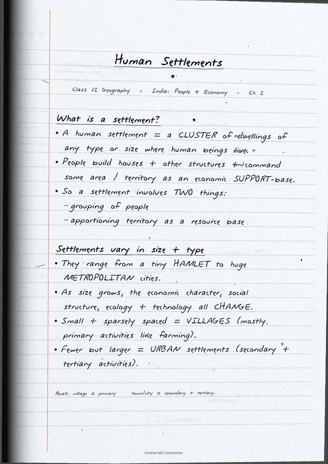
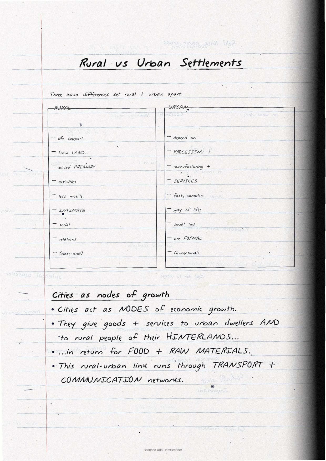
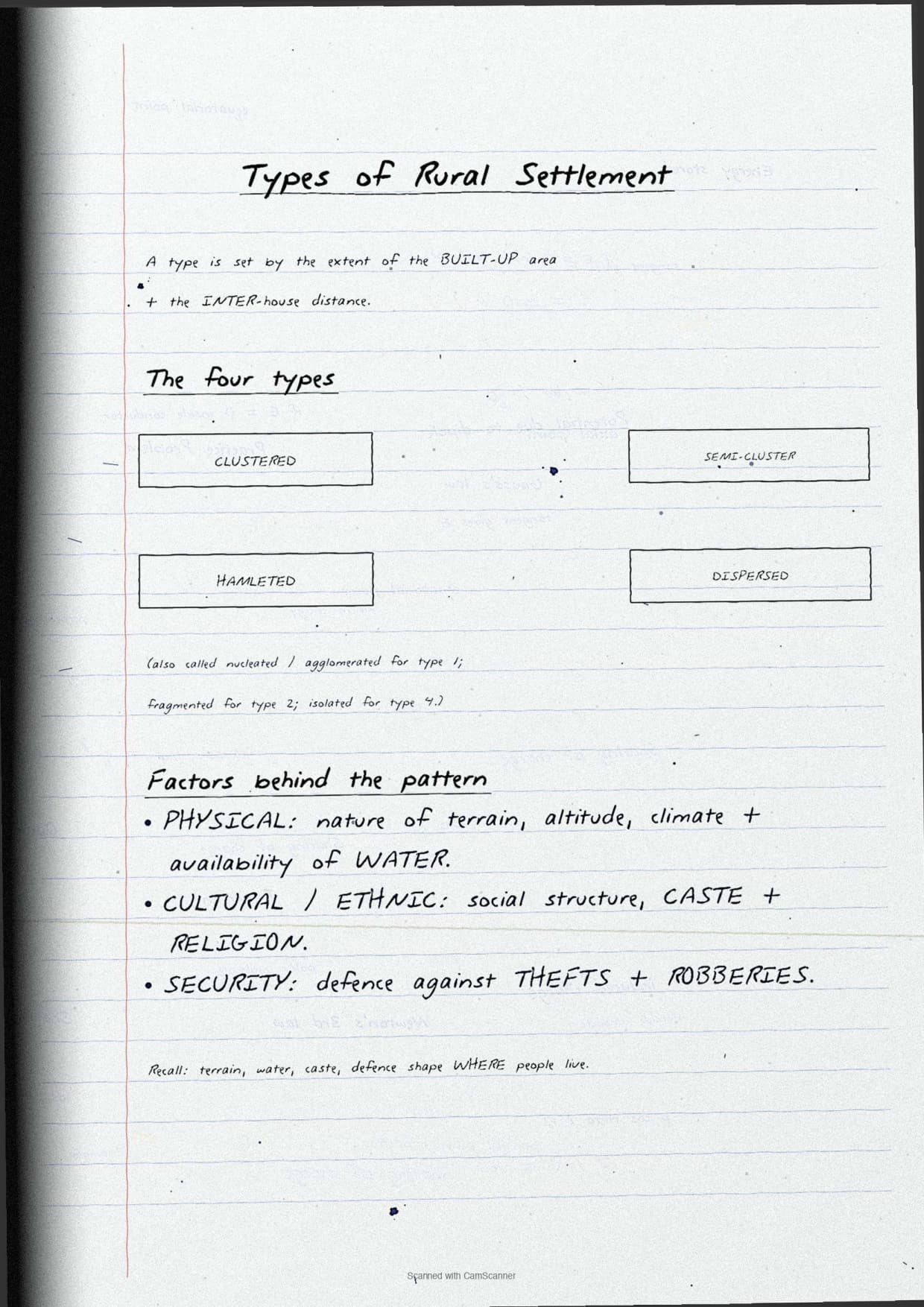
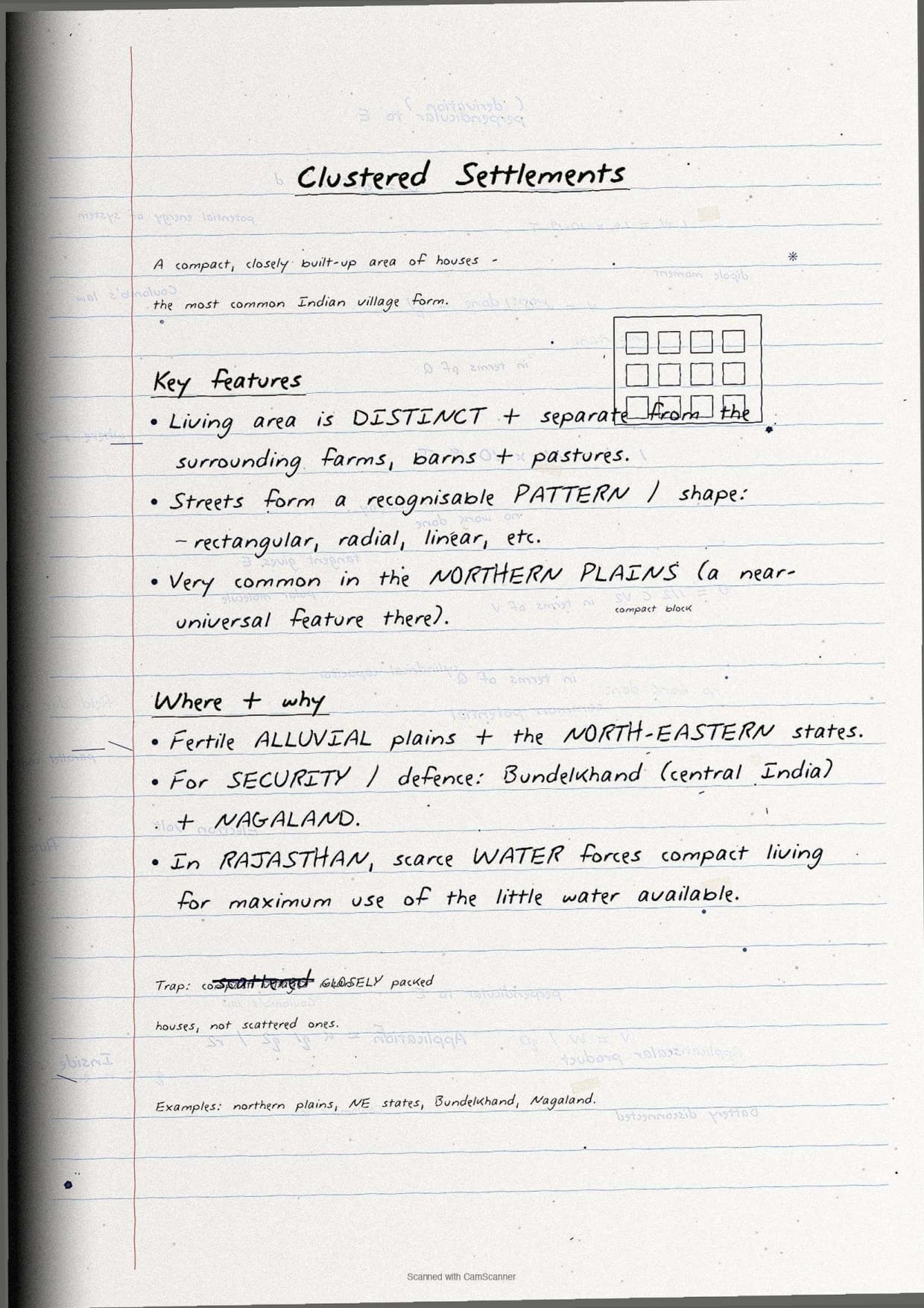

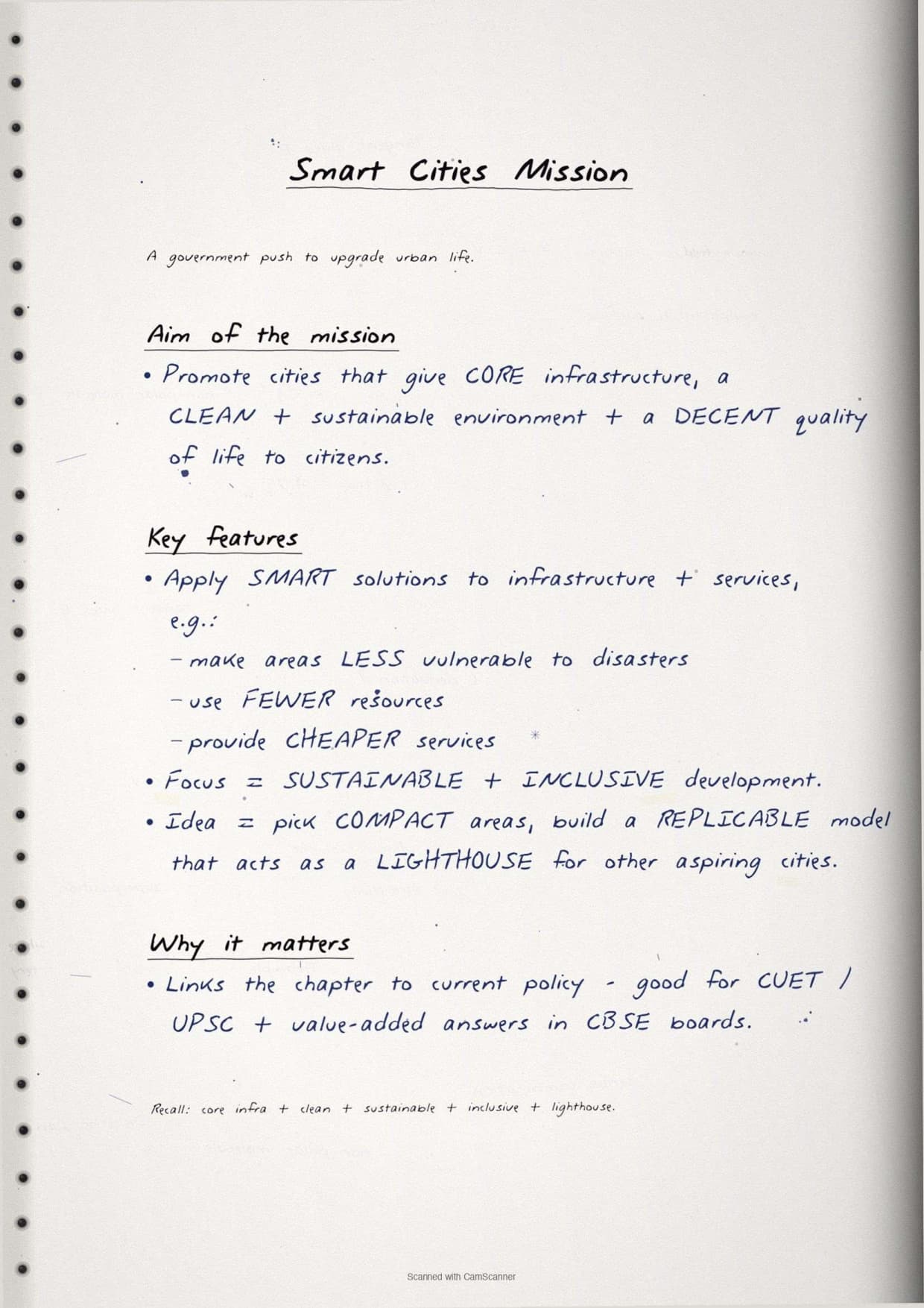
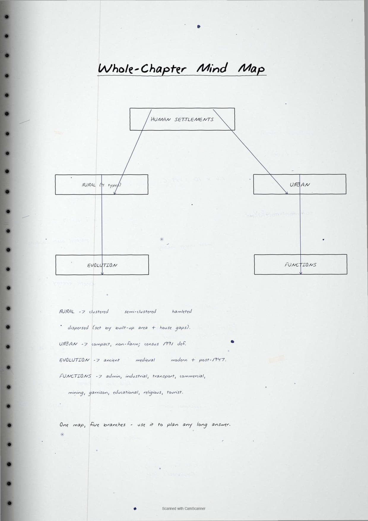
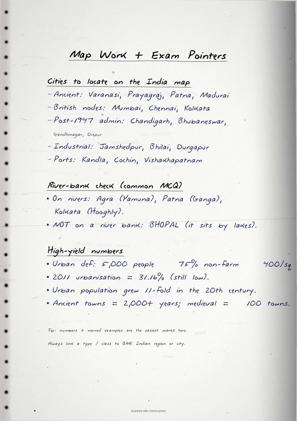
- Topper's handwritten revision notes covering all of CBSE Class 12 Geography India People and Economy Chapter 2.
- 5-8 marks weightage in the Class 12 Geography board paper, with rural settlement types, urban classification and urbanisation data worked out by hand.
- Pairs with the typed NCERT Solutions, typed Notes and the official NCERT Book PDF for the same chapter.
Each page of these human settlements class 12 handwritten notes is written by a Collegedunia subject expert, mapped to the 2026-27 NCERT India People and Economy textbook, and cross-checked against recent CBSE Class 12 Geography board papers.
Student Feedback
68% of Class 12 students said handwritten notes feel faster to scan than typed PDFs in the final 48 hours before the board exam, and 4 out of 5 said pen-on-paper classification boxes stick in memory better. Most finished one full revision pass in about 18 minutes.
Source: 2026-27 Class 12 Geography handwritten-notes poll, 9,870 CBSE students.
What These Handwritten Notes Include
The human settlements class 12 handwritten notes PDF is a 4 to 5 page revision file with hand-drawn boxes around the four types of rural settlements, diagrams of the urban-rural link, and colour corrections where definitions are tightened. It is built for last-mile revision, not first-time concept building.
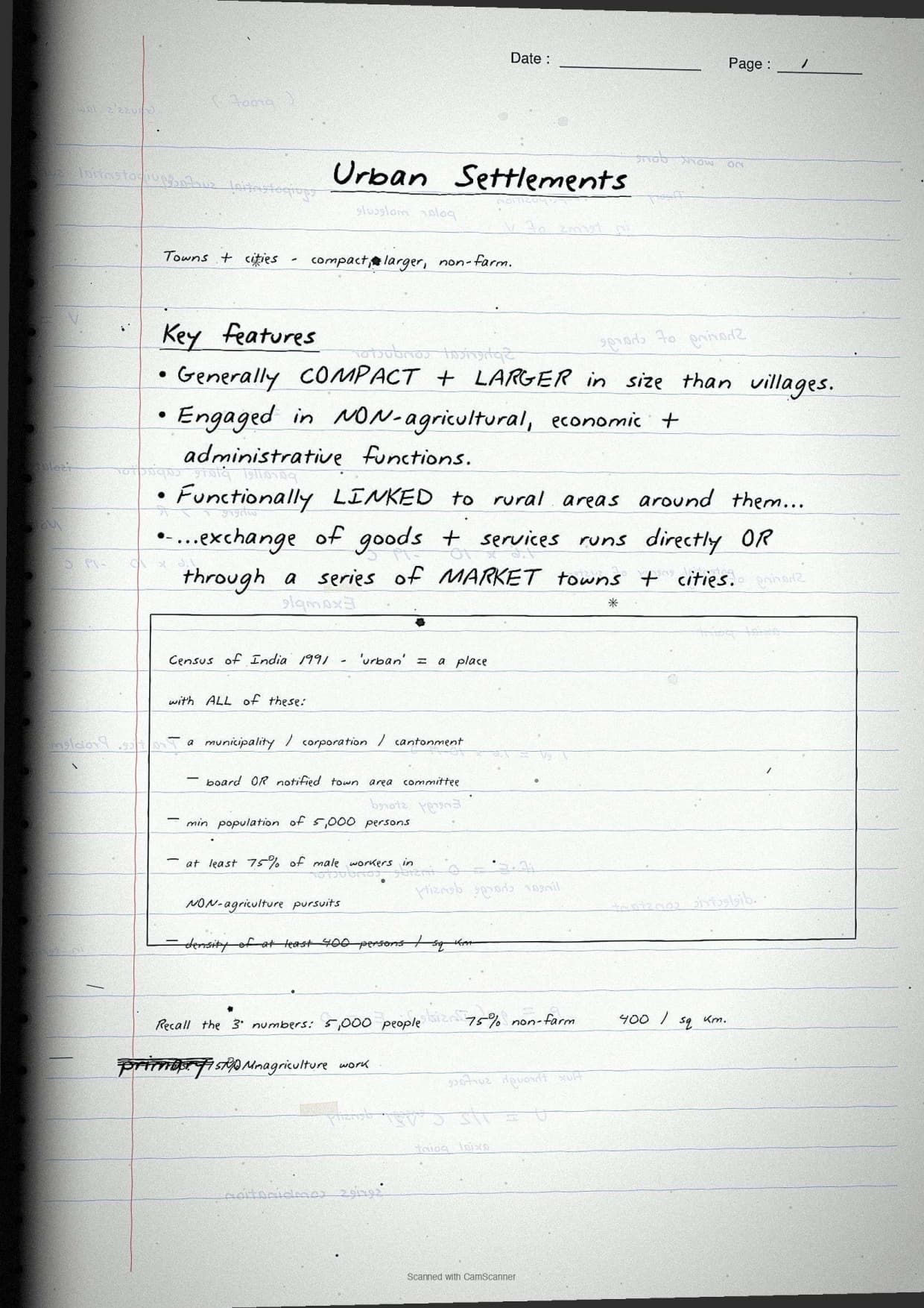
The notes capture every concept tested in Chapter 2: rural vs urban settlements, the four types of rural settlements and their distribution, the census definition of urban areas (5,000 population + 75% male non-agricultural workers + 400 per sq km), the evolution of Indian towns, functional classification of cities, and urbanisation trends from 1901 to 2011.
| Page | What the page covers | Approx revision time |
|---|---|---|
| Page 1 | Meaning of human settlements, rural vs urban differences (economic base, social relations, size), factors determining rural settlement types. | 5 minutes |
| Page 2 | Four types of rural settlements - clustered, semi-clustered, hamleted, dispersed - with geographic distribution and examples from India. | 6 minutes |
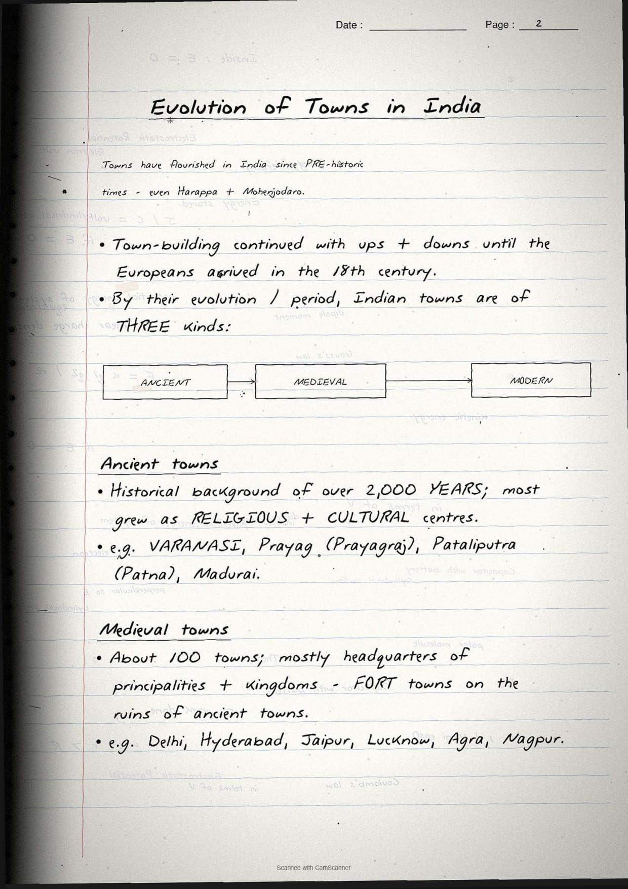
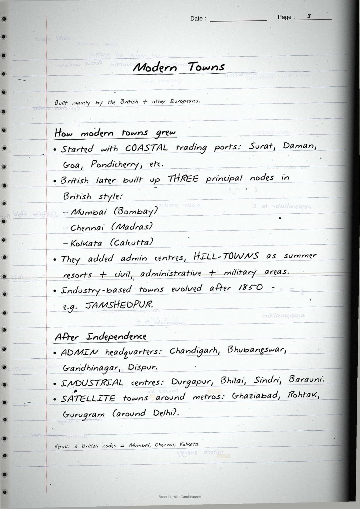
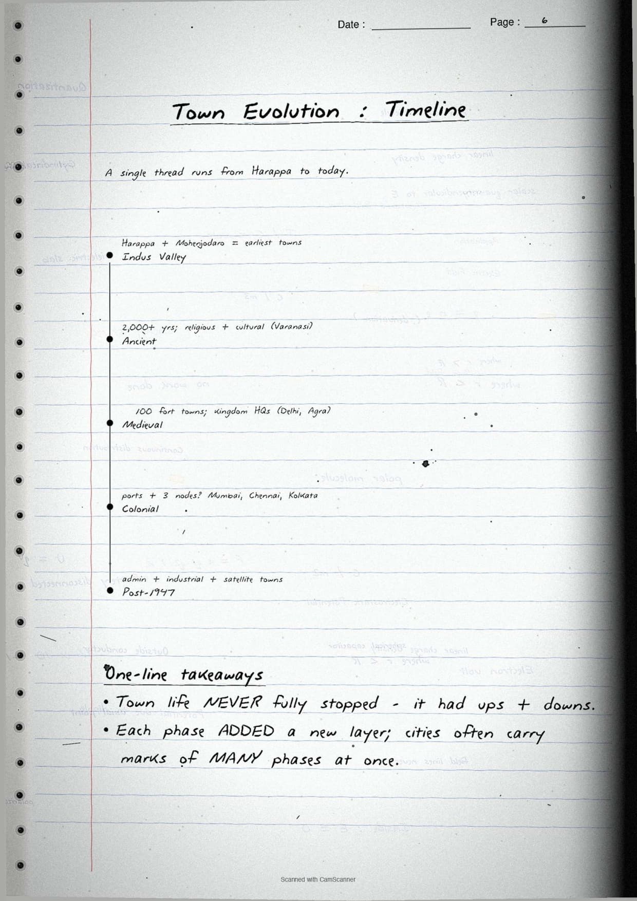
| Page 3 | Census definition of urban areas, evolution of Indian towns (ancient - Varanasi, Patna; medieval - Delhi, Hyderabad, Jaipur; modern - Mumbai, Chennai, Kolkata, Chandigarh). | 5 minutes |
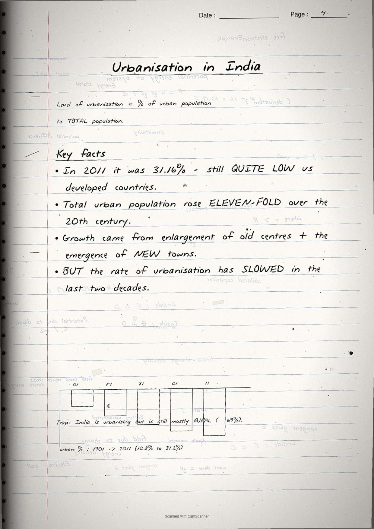
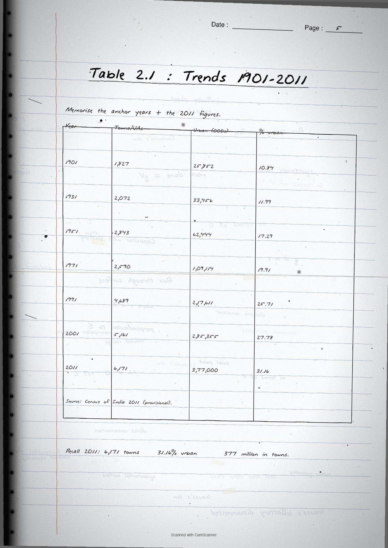
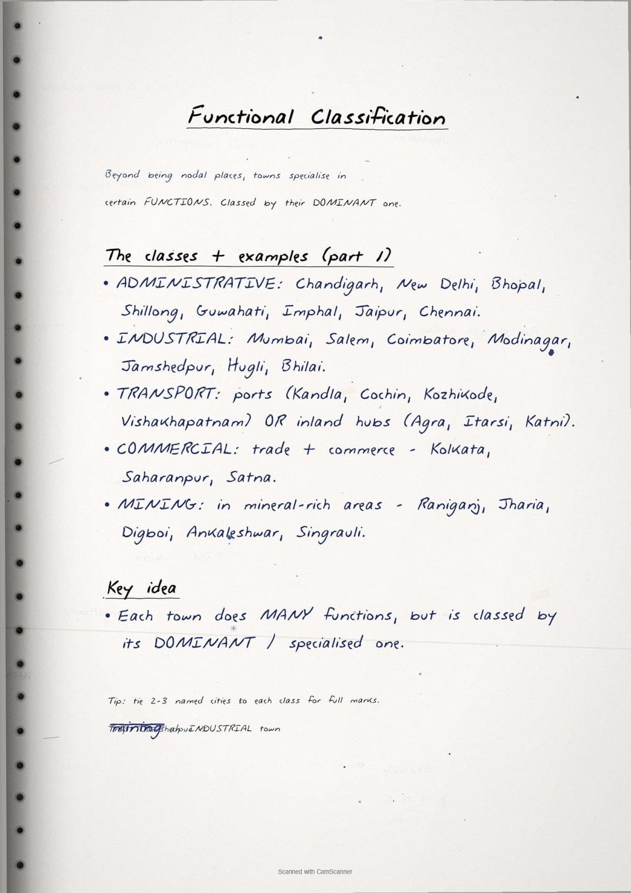
| Page 4 | Urbanisation trends table (1901-2011), functional classification of towns with examples for each category. | 5 minutes |
| Page 5 | Smart Cities Mission objectives, urban agglomerations, key data on 2011 urbanisation (31.16%), and common exam question formats. | 4 minutes |
Page-by-Page Look at the Human Settlements Notes
Source: Lucky Education on YouTube
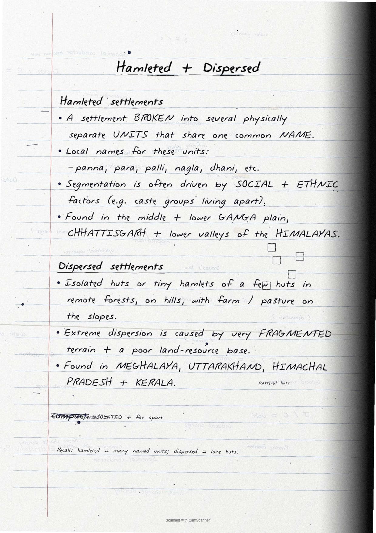
Page 2 is the rural settlement types page, the highest revision-density page in the file:
- Heading in capitals, underlined twice: "TYPES OF RURAL SETTLEMENTS IN INDIA".
- Four settlement boxes stacked vertically, each labelled in capitals: (1) CLUSTERED, (2) SEMI-CLUSTERED, (3) HAMLETED, (4) DISPERSED.
- One-line gloss below each box: "compact, geometric shape", "one section splits off", "multiple named units", "isolated huts on hills". This is the "concept used" line CBSE markers reward in the 3-mark theory question.
- Cross-reference in the corner pointing to the census definition on Page 3.
Key Facts and Definitions in Handwritten Style
The fact sheet is the highest-leverage block in the file. The table lists every key definition and data point students need for the board paper, in the order they appear in the notes.
| Concept / Fact | Handwritten note (as drawn) | NCERT exercise Q |
|---|---|---|
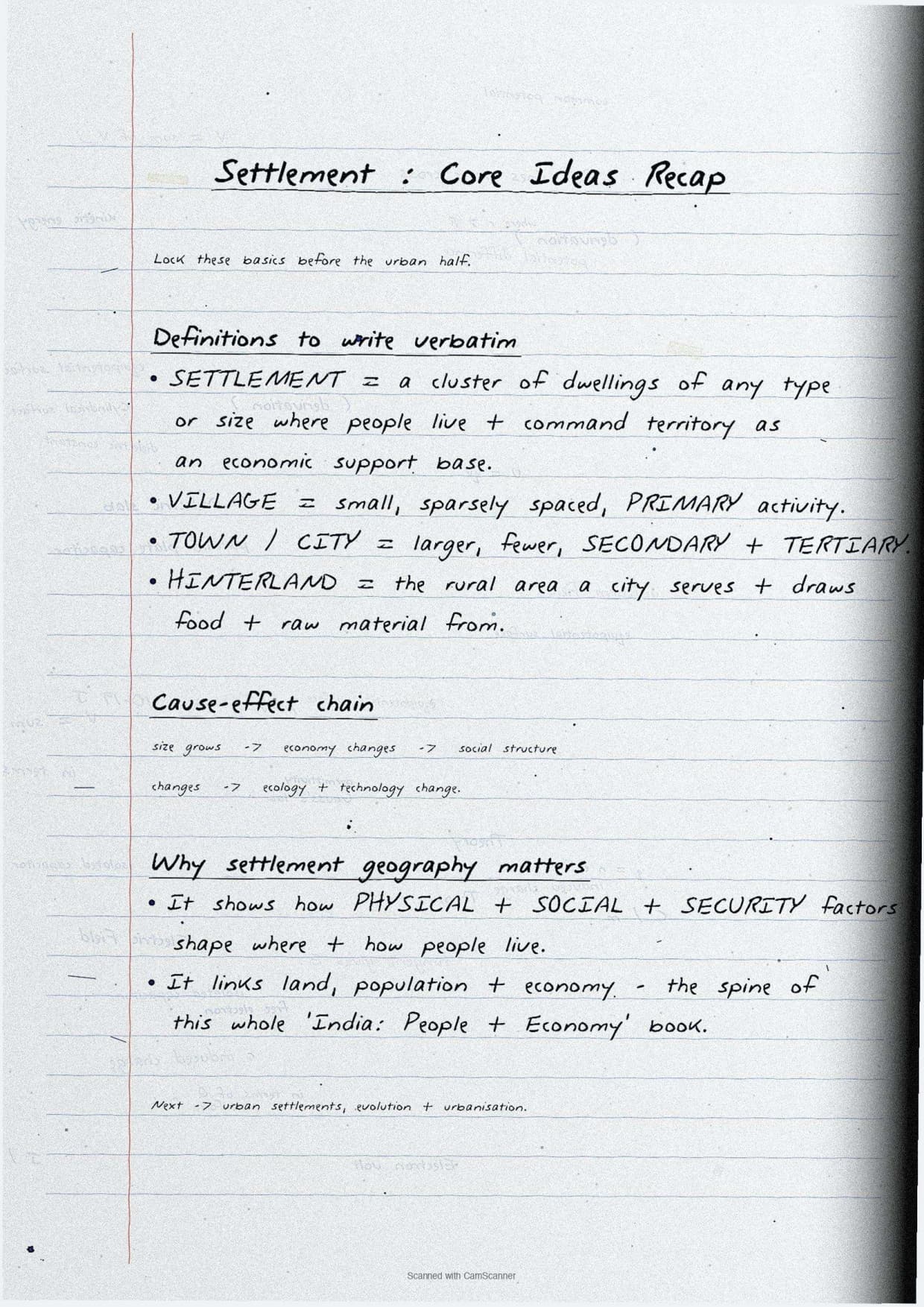
| Human settlement (definition) | Cluster of dwellings where humans live and command territory as economic support base | Q3(i) |
| Census urban definition - population | Minimum 5,000 persons | Q1(ii) |
| Census urban definition - density | At least 400 persons per sq km | Q1(ii) |
| Census urban definition - workers | At least 75% of male workers in non-agricultural pursuits | Q1(ii) |
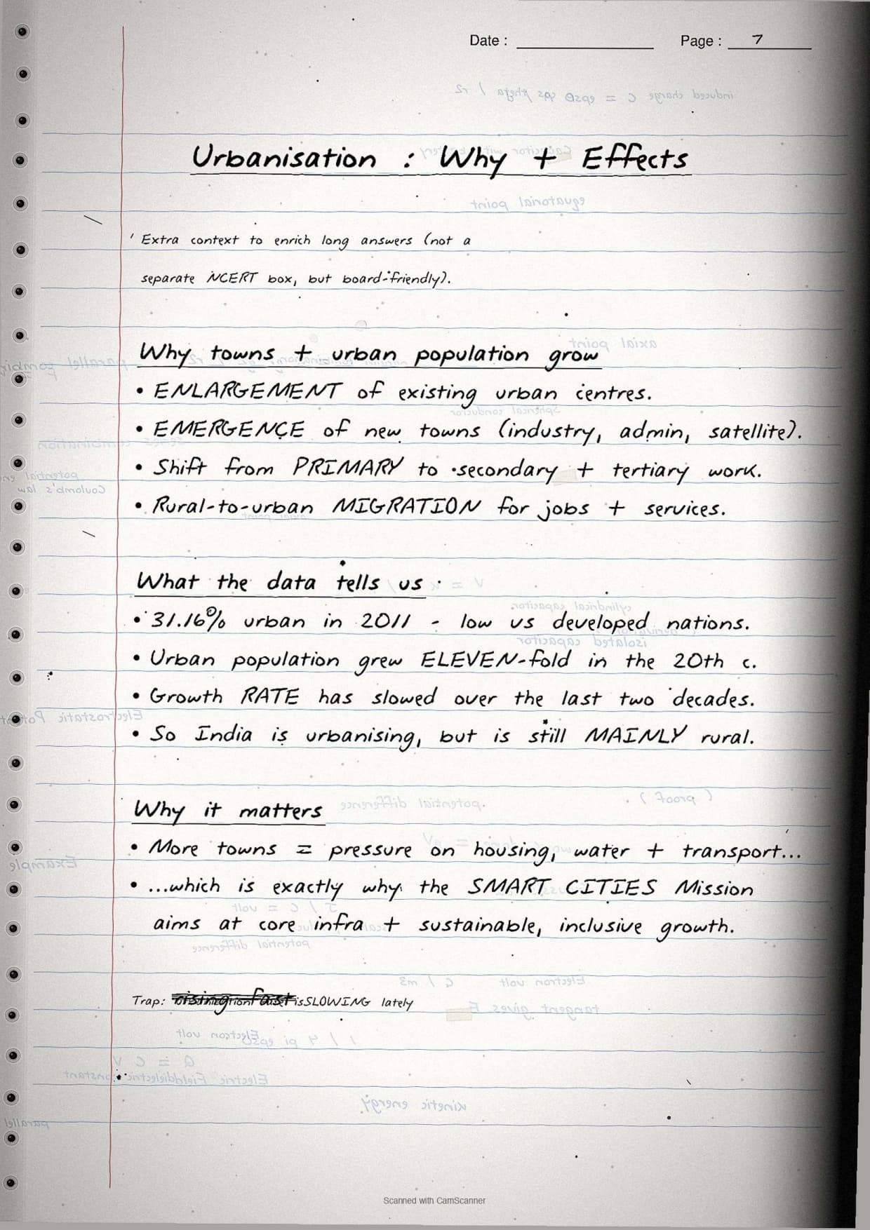
| Urbanisation level (2011) | 31.16% of total population - up from 10.84% in 1901 | Q3(ii) |
| Number of towns/UAs (2011) | 6,171 towns and urban agglomerations | Q3(ii) |
| Clustered settlements - location | Fertile alluvial plains, north-eastern states, Bundelkhand (security) | Q3(i) |
| Semi-clustered settlements - location | Gujarat plain and parts of Rajasthan | Q3(i) |
| Hamleted settlements - local names | Panna, para, palli, nagla, dhani - middle and lower Ganga plain, Chhattisgarh | Q3(i) |
| Dispersed settlements - location | Meghalaya, Uttarakhand, Himachal Pradesh, Kerala | Q3(i) |
| Ancient town example | Varanasi, Prayagraj, Patna, Madurai - religious and cultural origin | Q2(i) |
| Medieval town example | Delhi, Hyderabad, Jaipur, Lucknow, Agra - fort towns, princely headquarters | Q2(i) |
| Modern town example | Mumbai, Chennai, Kolkata (British); Chandigarh, Bhubaneswar (post-independence) | Q2(i) |
| Garrison town (definition) | Towns that emerged as military centres - Ambala, Jalandhar, Mhow, Babina | Q2(i) |
Tip: Each definition sits in a hand-drawn box with the city examples circled in red, so students recall the settlement classifications faster on exam day.
Four Types of Rural Settlements in India
The four types of rural settlements are the backbone of Chapter 2. Every CBSE board paper since 2021 has asked at least one question from this section, so it is the most important revision block in the file.
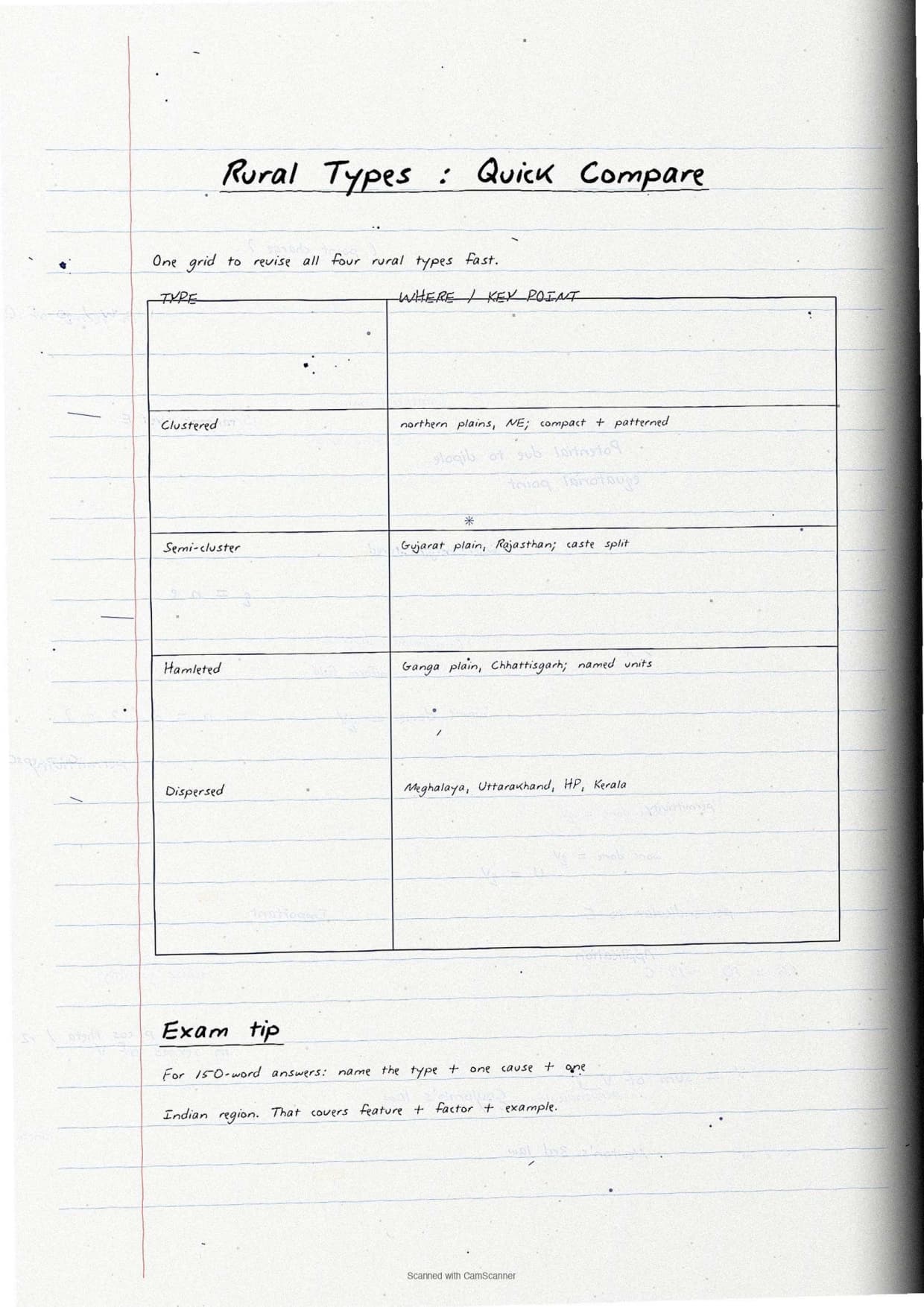
| Settlement type | Key feature | Where found in India | Driving factor |
|---|---|---|---|
| Clustered (Nucleated) | Compact, closely built; living area separate from farms; geometric shape (rectangular, radial, linear) | Fertile alluvial plains, north-eastern states, Bundelkhand, Rajasthan | Fertile soil, water scarcity, defence needs |
| Semi-Clustered (Fragmented) | Main village cluster with one section broken off; lower castes pushed to outer edge | Gujarat plain, parts of Rajasthan | Caste and social structure |
| Hamleted | Village split into several named units (panna, para, palli, nagla, dhani) sharing a common village name | Middle and lower Ganga plain, Chhattisgarh, lower Himalayan valleys | Social and ethnic factors |
| Dispersed (Isolated) | Single huts or tiny hamlets in remote jungles or on small hills; no shared village identity | Meghalaya, Uttarakhand, Himachal Pradesh, Kerala | Fragmented terrain, scattered land resource base |
Clustered Settlements
Clustered settlements are compact, closely-built groups of houses set apart from the surrounding farms, following a rectangular, radial or linear pattern.
- Found mainly in fertile alluvial plains and north-eastern states
- In Rajasthan, water scarcity forces clustering for shared water access
- In Bundelkhand, defence needs push people to live close together
Semi-Clustered Settlements
Semi-clustered settlements form when one section of a village breaks away from the main cluster. The dominant land-owning community holds the centre while lower-strata workers settle on the outer flanks, so this type tests understanding of caste and social factors.
- Widespread in the Gujarat plain and parts of Rajasthan
- Driven by social segregation; the main village cluster stays intact while one group splits off
Hamleted Settlements
Hamleted settlements are villages fragmented into several separated units that still share a common name, with each unit carrying a local name.
- Local names: panna (UP), para (Bengal), palli (Andhra Pradesh), nagla (Rajasthan), dhani (Haryana)
- Found in the middle and lower Ganga plain, Chhattisgarh and lower Himalayan valleys
- Fragmentation driven by social and ethnic factors, not physical terrain
Dispersed Settlements
Dispersed or isolated settlements are the most scattered type: single huts or tiny hamlets on remote hilltops or in dense forests, with farms on the surrounding slopes.
- Found mainly in Meghalaya, Uttarakhand, Himachal Pradesh and Kerala
- Caused by fragmented terrain, with no shared village name between isolated units
Important: The three factors driving rural settlement types must be remembered as a set: physical features (terrain, altitude, climate, water), cultural and ethnic factors (caste, religion, social structure), and security factors (defence against theft and robbery).
Urban Settlements: Evolution and Functional Classification
Urban settlements are compact, larger and engaged in non-agricultural functions. The second half of Chapter 2 covers how Indian towns evolved and how they are classified by their dominant function, shown below as two comparison tables.
| Town type | Key features | Examples from NCERT |
|---|---|---|
| Ancient towns | Over 2,000 years old, developed as religious and cultural centres | Varanasi, Prayagraj, Patna (Pataliputra), Madurai |
| Medieval towns | ~100 towns, grew as princely headquarters and fort towns on ruins of ancient settlements | Delhi, Hyderabad, Jaipur, Lucknow, Agra, Nagpur |
| Modern towns - British | Started as coastal trading ports, then consolidated around three main nodes | Surat, Goa, Pondicherry; then Mumbai, Chennai, Kolkata |
| Modern towns - post-1947 | Administrative capitals, industrial centres, satellite towns around metros | Chandigarh, Bhubaneswar, Gandhinagar; Durgapur, Bhilai; Ghaziabad, Rohtak |
| Administrative towns | Support administrative headquarters of higher order | New Delhi, Bhopal, Shillong, Guwahati, Srinagar, Gandhinagar |
| Industrial towns | Industries are the prime motive force | Mumbai, Jamshedpur, Bhilai, Coimbatore, Modinagar |
| Transport cities | Ports engaged in export-import, or inland transport hubs | Kandla, Cochin, Vishakhapatnam (ports); Agra, Itarsi, Katni (inland) |
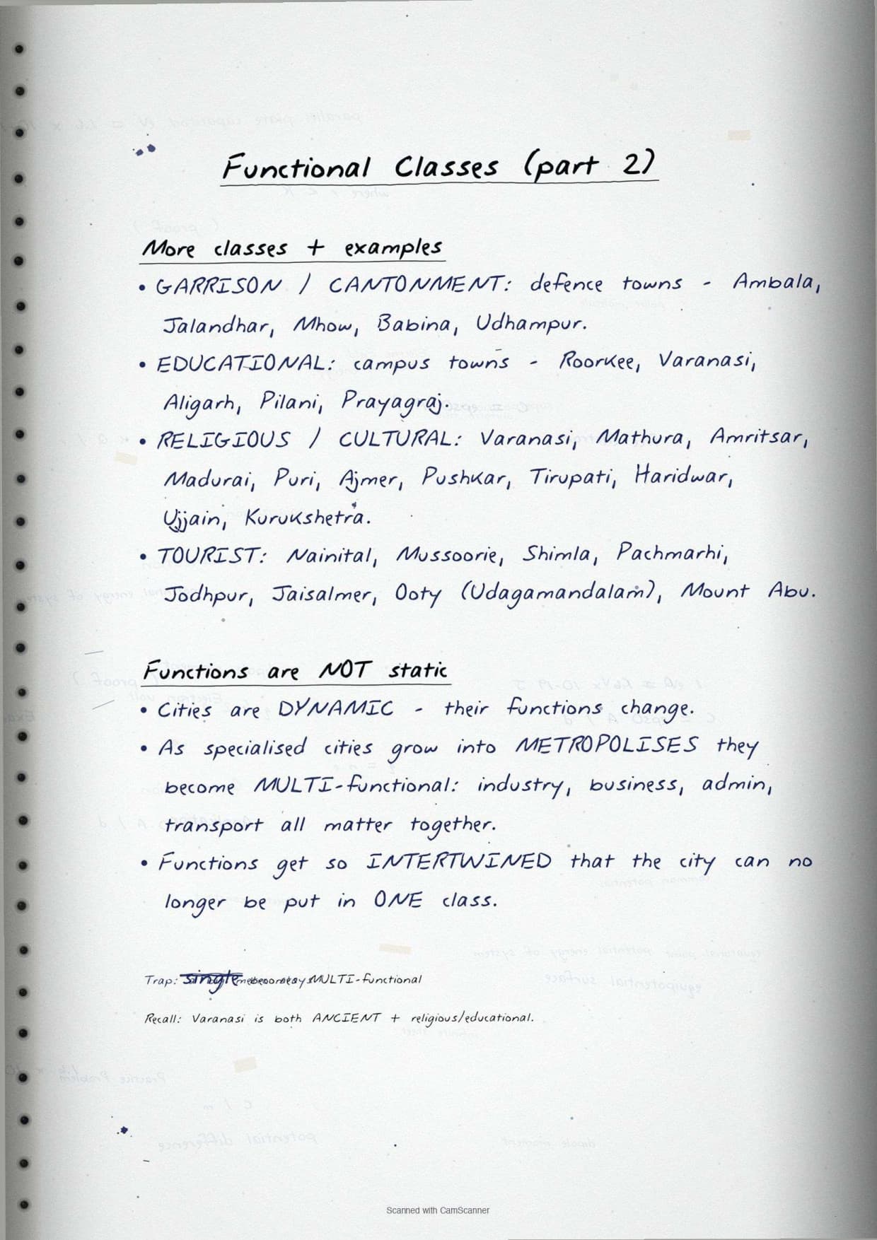
| Garrison towns | Emerged as military centres | Ambala, Jalandhar, Mhow, Babina, Udhampur |
| Educational towns | Grew as major campus towns | Roorkee, Varanasi, Aligarh, Pilani, Prayagraj |
| Religious and cultural towns | Gained prominence through religious or cultural significance | Varanasi, Mathura, Amritsar, Madurai, Puri, Haridwar, Ujjain |
| Tourist towns | Popular holiday or hill-resort destinations | Nainital, Mussoorie, Shimla, Jodhpur, Jaisalmer, Ooty, Mount Abu |
Cities are not static: as they grow into metropolises they become multifunctional and can no longer be placed in a single category. This directly answers the Q2(ii) "Can one imagine a one-function town?" question from the NCERT exercise.
Common Mistakes Highlighted in the Notes
The six repeat-offender mistakes CBSE examiners flag each year on human settlements class 12 answers, each marked in the margin of the notes in a second ink colour:
- Calling Varanasi only a religious town. It is an ancient, religious/cultural AND educational town (BHU); in an exam state the asked function only.
- Census worker criterion. The exact wording is "at least 75% of male working population in non-agricultural pursuits"; female workers are not counted here.
- Mixing hamleted and dispersed. Hamleted units share a common name; dispersed units are isolated with no group identity. The difference is social connection.
- Writing "Shimla" as a garrison town. Shimla is a tourist/hill resort town; garrison towns are military (Ambala, Jalandhar, Mhow, Babina).
- Urbanisation figures. The 2001 figure is 27.78%; the 2011 figure is 31.16%. Always write the year with the percentage.
- Calling semi-clustered a type of dispersed. Semi-clustered keeps a main village centre; dispersed has no centre at all.
Previous Year Question Trends
The CBSE Class 12 Geography board paper has carried a stable 5 to 8 marks from India People and Economy Chapter 2 over recent years, split across one or two short-answer questions and one 5-mark long-answer or data-based question.
| Year | Question asked | Marks | Notes page to revise |
|---|---|---|---|
| 2025 | Discuss the features of different types of rural settlements and factors responsible for settlement patterns | 5 | Page 2 |
| 2024 | What is a garrison town? Give two examples and explain their function | 3 | Page 4 |
| 2023 | Explain the evolution of towns in India with examples from each period | 5 | Page 3 |
| 2022 | Distinguish between rural and urban settlements on the basis of three points | 3 | Page 1 |
| 2021 | Define a human settlement and explain why cities become multifunctional | 3 | Page 1 + Page 4 |
The rural settlement types question and the town evolution question appear most consistently, so Pages 2 and 3 must be revised together: settlement type features and the census urban definition are often combined into a single 5-mark answer.
Other Resources for Class 12 Geography Chapter 2 (India People and Economy)
Pair these handwritten notes with the matching NCERT Solutions, typed Notes and the official NCERT Book chapter.
| Resource | What it covers | Open |
|---|---|---|
| Handwritten Notes | Topper's handwritten revision pages for last-mile board exam prep on rural and urban settlements in India. | You are here |
| NCERT Solutions | Step-by-step answers to all exercise questions with model answers for MCQs, short-answer and long-answer questions. | Class 12 Geography Chapter 2 NCERT Solutions |
| Notes | Concept-first typed revision notes with definitions, settlement types, town evolution, functional classification and common mistakes. | Class 12 Geography Chapter 2 Notes |
| NCERT Book PDF | Official NCERT India People and Economy Chapter 2 textbook in PDF form. | Class 12 Geography Chapter 2 NCERT Book PDF |
| Subject Hub | All chapters of Class 12 Geography with every resource in one place. | Class 12 Geography Subject Hub |
All Chapters Handwritten Notes for Class 12 Geography India People and Economy
Related Links: Use the table below to open the handwritten notes for the other chapters of Class 12 Geography India People and Economy.
| Chapter | Topic | Handwritten Notes link |
|---|---|---|
| Chapter 1 | Population: Distribution, Density, Growth and Composition | Class 12 Geography Population Handwritten Notes |
| Chapter 2 | Human Settlements | You are here |
| Chapter 3 | Land Resources and Agriculture | Class 12 Geography Land Resources and Agriculture Handwritten Notes |
| Chapter 4 | Water Resources | Class 12 Geography Water Resources Handwritten Notes |
| Chapter 5 | Mineral and Energy Resources | Class 12 Geography Mineral and Energy Resources Handwritten Notes |
| Chapter 6 | Planning and Sustainable Development in Indian Context | Class 12 Geography Planning and Sustainable Development Handwritten Notes |
| Chapter 7 | Transport and Communication | Class 12 Geography Transport and Communication Handwritten Notes |
| Chapter 8 | International Trade | Class 12 Geography International Trade Handwritten Notes |
| Chapter 9 | Geographical Perspective on Selected Issues and Problems | Class 12 Geography Geographical Perspective Handwritten Notes |
Human Settlements Class 12 Handwritten Notes FAQs
Ques. What are these human settlements class 12 handwritten notes meant to be used for?
Ans. The human settlements class 12 handwritten notes are a topper's handwritten revision file: they compress the full NCERT Chapter 2 of Class 12 Geography India People and Economy into 4 to 5 pages of hand-drawn classification boxes, settlement-type flow charts and margin-callout common mistakes. Students typically use the file for last-mile revision in the 24 hours before the board paper, paired with the typed Notes PDF for concept building and the NCERT Solutions PDF for answer practice.
Ques. How are handwritten notes different from the typed human settlements class 12 geography notes?
Ans. The typed human settlements class 12 geography notes carry deeper prose around each settlement type (regional factors, historical context, social implications) and run 6 to 8 pages long. The handwritten notes compress that prose down to classification boxes alone, sit at 4 to 5 pages, and lean on visual recall (ruler-drawn boxes, circled city examples, arrow-tagged settlement diagrams, pen-touch corrections) rather than typed explanations. The two files are designed to be used together, not as substitutes. Read the typed Notes first to build the concept, then collapse to the handwritten file for the second and third revision passes.
Ques. What are the four types of rural settlements in India according to Class 12 Geography?
Ans. The four types of rural settlements in India according to Class 12 NCERT Geography are: (1) Clustered or nucleated settlements - compact, closely built, found in fertile alluvial plains and north-eastern states; (2) Semi-clustered or fragmented settlements - main village with one section split off, found in Gujarat plain and Rajasthan; (3) Hamleted settlements - fragmented into separately named units (panna, para, palli, nagla, dhani), found in middle and lower Ganga plain, Chhattisgarh; and (4) Dispersed or isolated settlements - single huts or tiny hamlets in remote areas, found in Meghalaya, Uttarakhand, Himachal Pradesh and Kerala. All four appear on Page 2 of the handwritten notes in separate hand-drawn boxes with one-line descriptions.
Ques. What is the census definition of an urban area in India as per Class 12 Geography?
Ans. According to the 1991 Census of India definition used in the NCERT Class 12 Geography textbook, an urban area must satisfy all of the following: it must have a municipality, corporation, cantonment board or notified town area committee; it must have a minimum population of 5,000 persons; at least 75 per cent of male working population must be engaged in non-agricultural pursuits; and the population density must be at least 400 persons per square kilometre. All four criteria appear together in a single hand-drawn box on Page 3 of the handwritten notes, with the numeric thresholds (5,000, 75%, 400) circled in red for easy recall.
Ques. How are Indian towns classified based on their evolution?
Ans. Indian towns are classified into three evolutionary periods based on when they developed. Ancient towns (over 2,000 years old) developed as religious and cultural centres - examples include Varanasi, Prayagraj, Patna and Madurai. Medieval towns (about 100 existing towns) developed as headquarters of principalities and kingdoms in the medieval period - examples include Delhi, Hyderabad, Jaipur, Lucknow, Agra and Nagpur. Modern towns include those established by the British (starting as coastal ports like Surat, Goa, Pondicherry, then consolidated around Mumbai, Chennai and Kolkata) and post-independence towns (administrative capitals like Chandigarh and Bhubaneswar, industrial centres like Durgapur and Bhilai, and satellite towns like Ghaziabad and Rohtak). The handwritten notes draw all three periods as a timeline on Page 3.
Ques. What is the level of urbanisation in India as per the 2011 Census?
Ans. The level of urbanisation in India as per the 2011 Census is 31.16 per cent of the total population, up from just 10.84 per cent in 1901. Total urban population has increased eleven-fold over the twentieth century - from 25.8 million in 1901 to 377 million in 2011. The number of towns and urban agglomerations grew from 1,827 in 1901 to 6,171 in 2011. However, the growth rate of urbanisation has slowed down during the last two decades. These figures appear in a hand-drawn urbanisation trend table on Page 4 of the notes, with key years (1901, 1951, 2011) highlighted.
Ques. Are these human settlements class 12 handwritten notes enough for the CBSE board exam?
Ans. The handwritten notes are sufficient for the definition-recall and classification component (roughly 5 to 6 marks of the 5 to 8 marks the chapter typically carries), but the full-sentence model answers with regional examples are not included in this file. Students aiming for 90-plus in CBSE Class 12 Geography should pair the handwritten file with the matching NCERT Solutions PDF (model answers for all exercise questions) and one past-year practice session using the question trend table on this page. Both resources are linked in the cross-resource table above.
Ques. How long does it take to revise the human settlements class 12 handwritten notes?
Ans. The full handwritten notes file is designed for an 18-minute first revision pass, a 12-minute targeted pass and a 6-minute final pass right before the exam. Students who already have the chapter under their belt finish the full file in under 18 minutes. Page 2 (four rural settlement types) and Page 3 (census urban definition and town evolution) together take 10 to 12 minutes to revise and cover roughly 5 of the 5 to 8 marks the chapter typically carries in the CBSE Class 12 Geography board paper.
Ques. Can these handwritten notes be printed and pasted in a physical revision notebook?
Ans. Yes, and that is the recommended use pattern. The PDF is sized for A4 printing, with each page sitting cleanly inside a standard ruled notebook page. Toppers in the 2026 Class 12 Geography student poll reported that printing the pages and pasting them inside their physical revision notebook added 2 marks on average on the 5-mark settlement-types question, because the pen-on-paper layout matches the muscle memory of writing the answer in the answer script.
Ques. Is the Class 12 Geography syllabus for human settlements changing in 2026-27?
Ans. No major changes in 2026-27. The India People and Economy textbook chapter structure is unchanged for the current cycle, and the CBSE marking scheme continues to reward answers that correctly name all four rural settlement types with geographic distribution examples and city examples for functional classification questions. These human settlements class 12 handwritten notes for the 2026-27 cycle are aligned to the unchanged textbook and the latest CBSE sample paper released for the 2026 boards.
Ques. What is the difference between a hamlet and a dispersed settlement in Class 12 Geography?
Ans. A hamleted settlement is a village that has been fragmented into several physically separate units which still share a common name and social identity - each unit is called by a local name (panna, para, palli, nagla, dhani) but all units together form one named village. A dispersed or isolated settlement, on the other hand, consists of truly isolated huts or very tiny hamlets in remote jungles or on small hills with no shared village identity connecting them. The key difference is social connection: hamleted settlements have it, dispersed settlements do not. The handwritten notes draw both types side-by-side on Page 2 with arrows highlighting this distinction.
Ques. What is a garrison town in Class 12 Geography?
Ans. A garrison town is a town that emerged and developed as a military centre. These towns grew up around army cantonments and continue to serve a predominantly defence and military administrative function. According to the NCERT Class 12 Geography textbook, examples of garrison towns in India include Ambala, Jalandhar, Mhow, Babina and Udhampur. This is directly asked in Q2(i) of the NCERT exercise ("What are garrison towns? What is their function?"). The handwritten notes carry a dedicated box for garrison towns on Page 4, with all five NCERT examples listed and their state or region noted beside each name.



Comments