




These Class 12 Geography Chapter 3 Land Resources and Agriculture handwritten notes are a topper's genuine handwritten revision pages for quick last-mile revision, in line with the 2026-27 CBSE syllabus. The pages cover all four major topics: land-use categories, changes in land use, types of farming and cropping seasons, and major crops of India. Use the PDF in the 24 hours before the board paper.
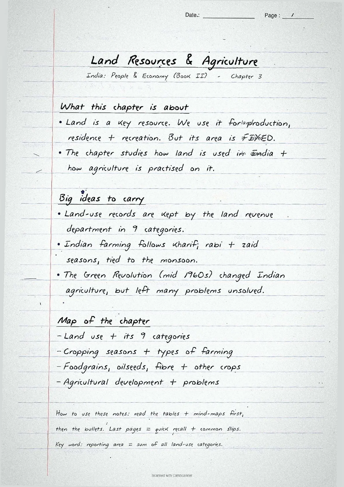
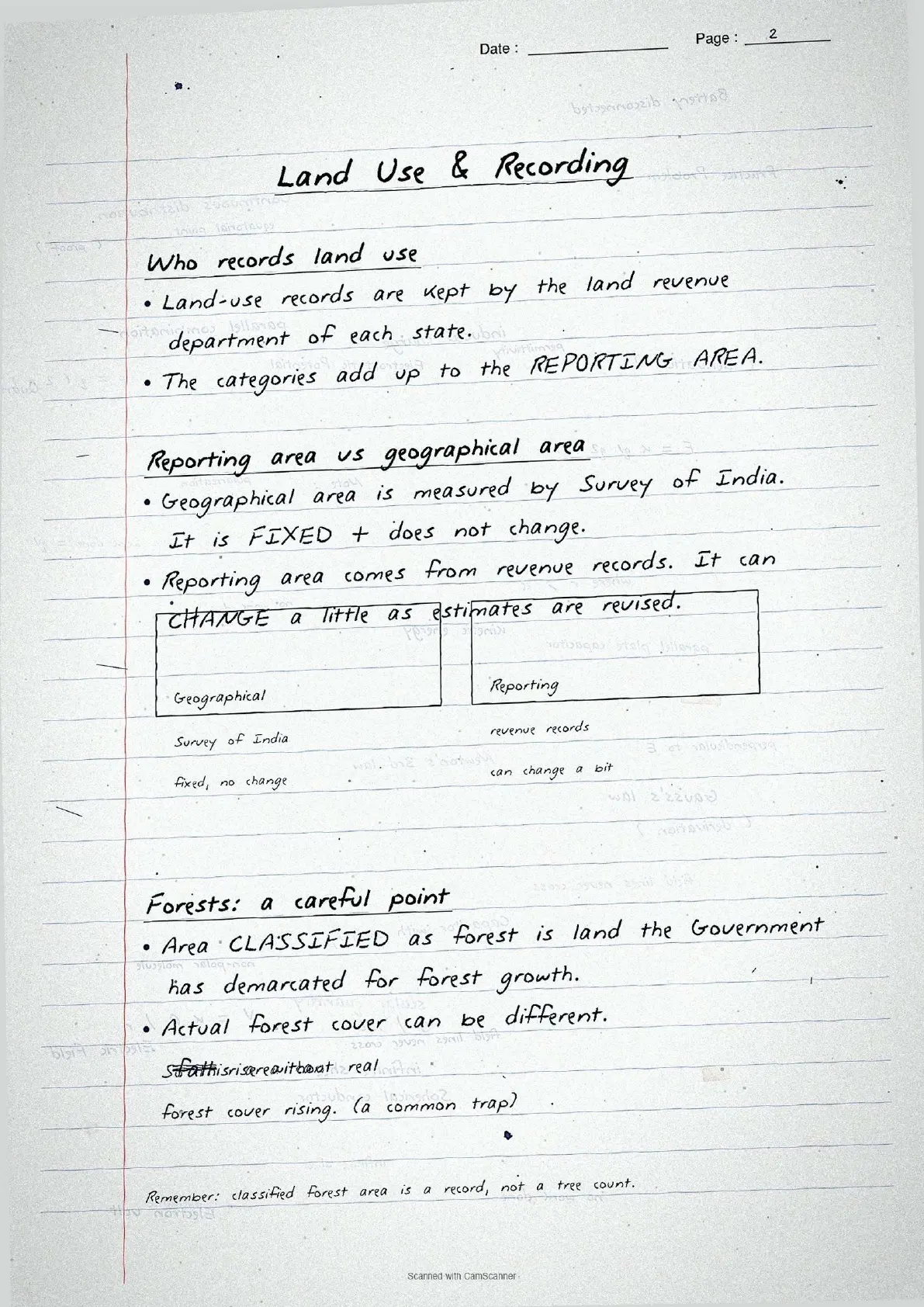
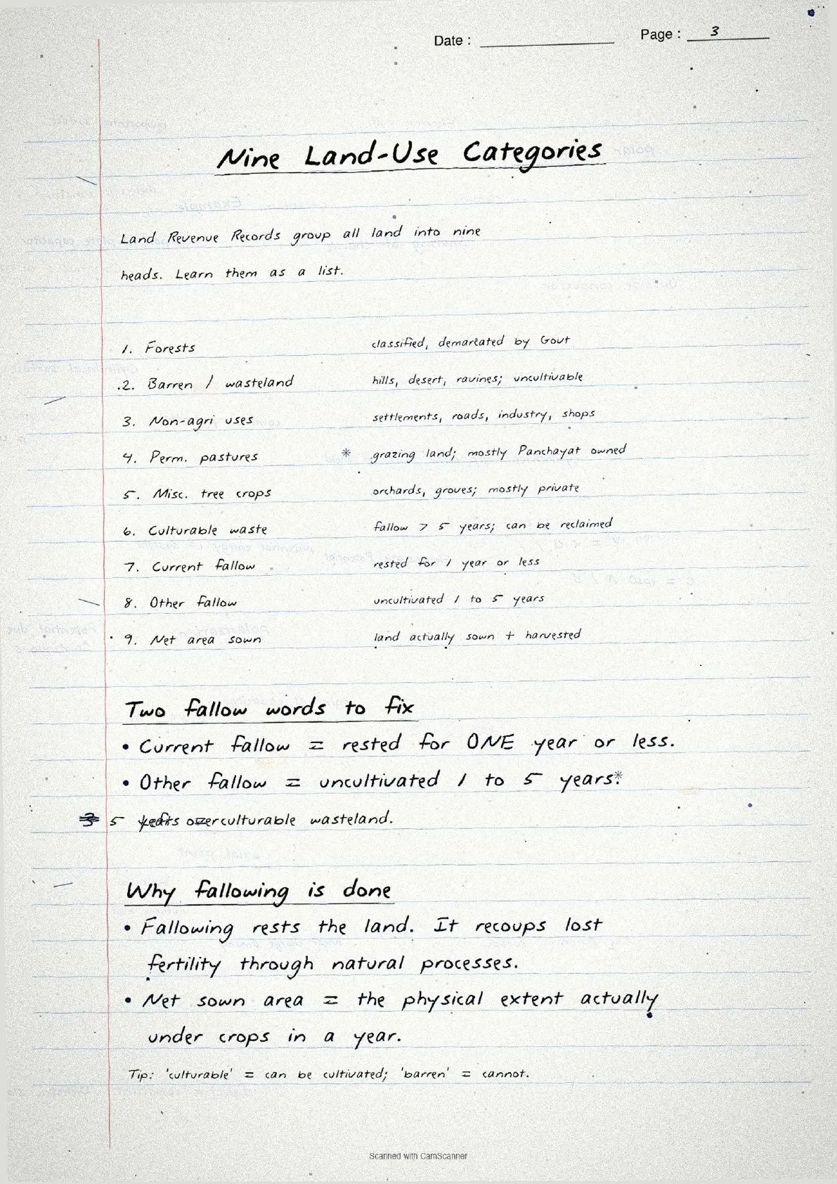
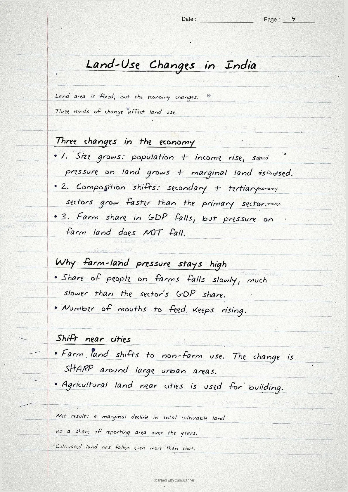

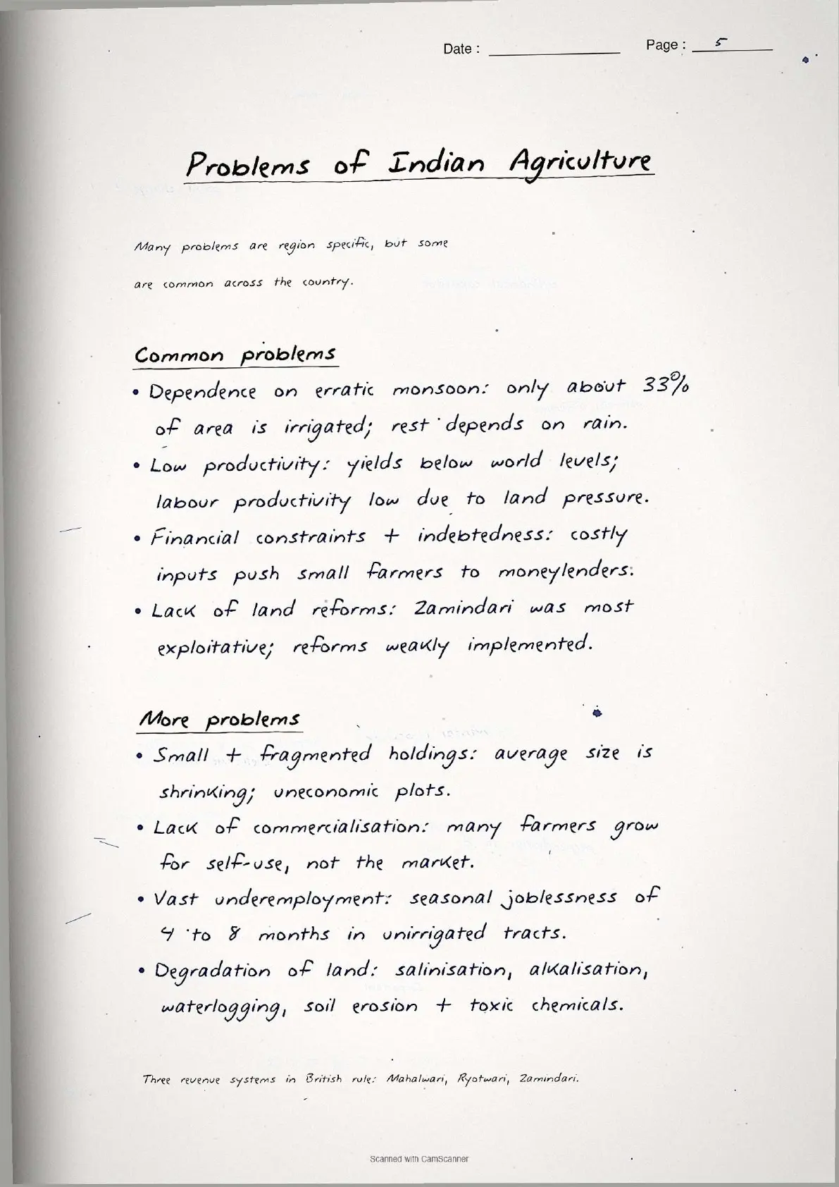
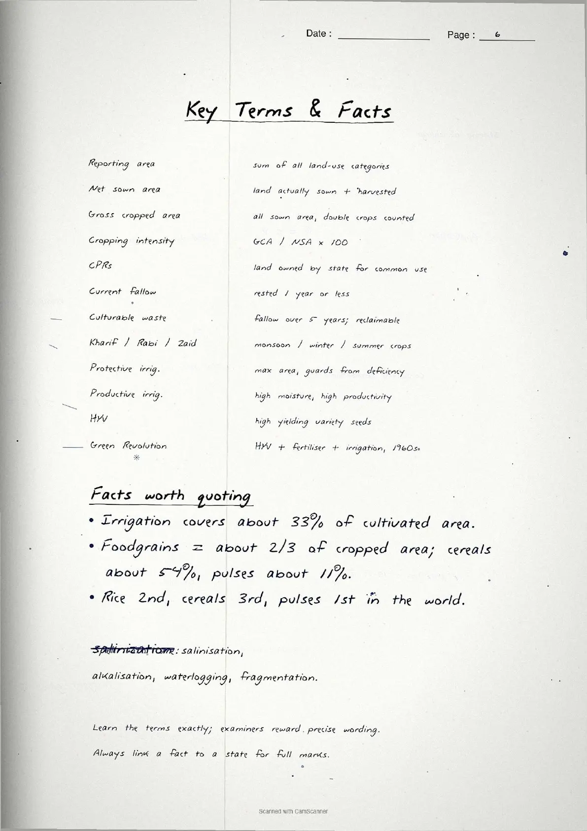
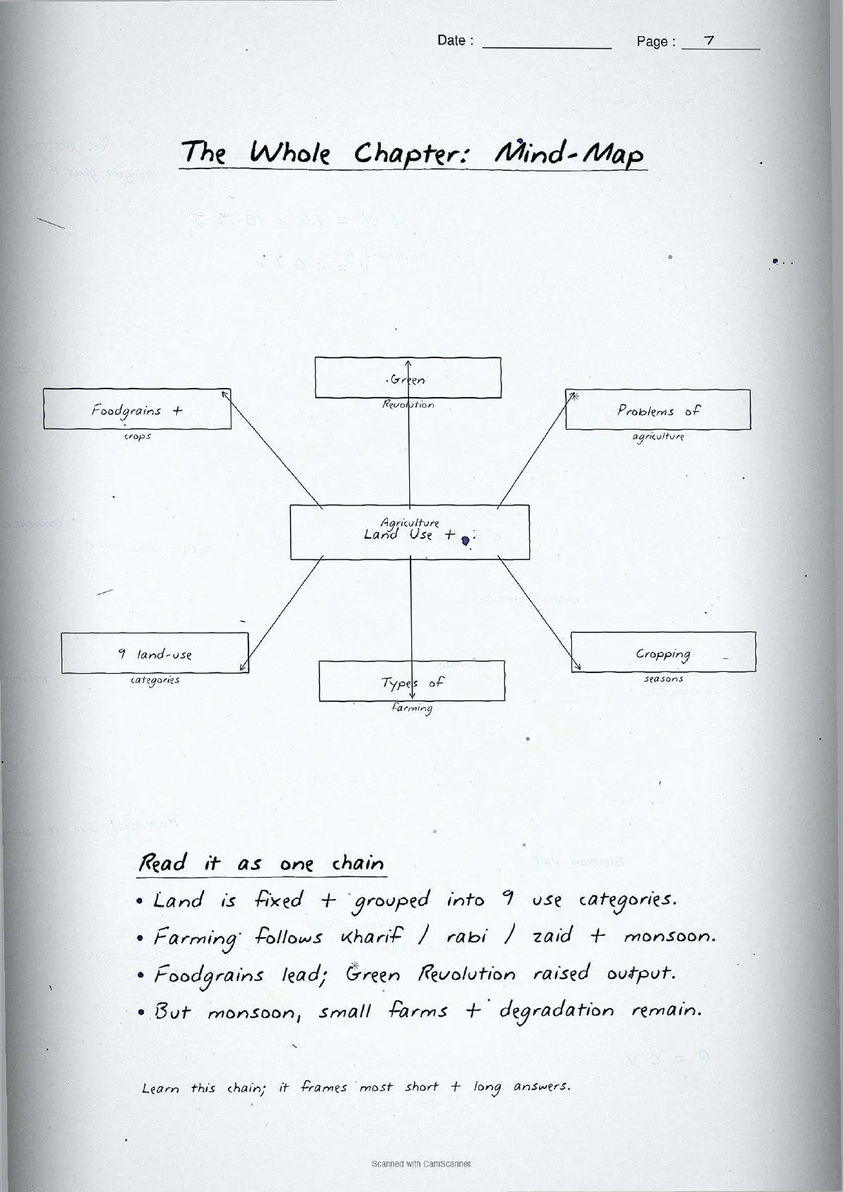
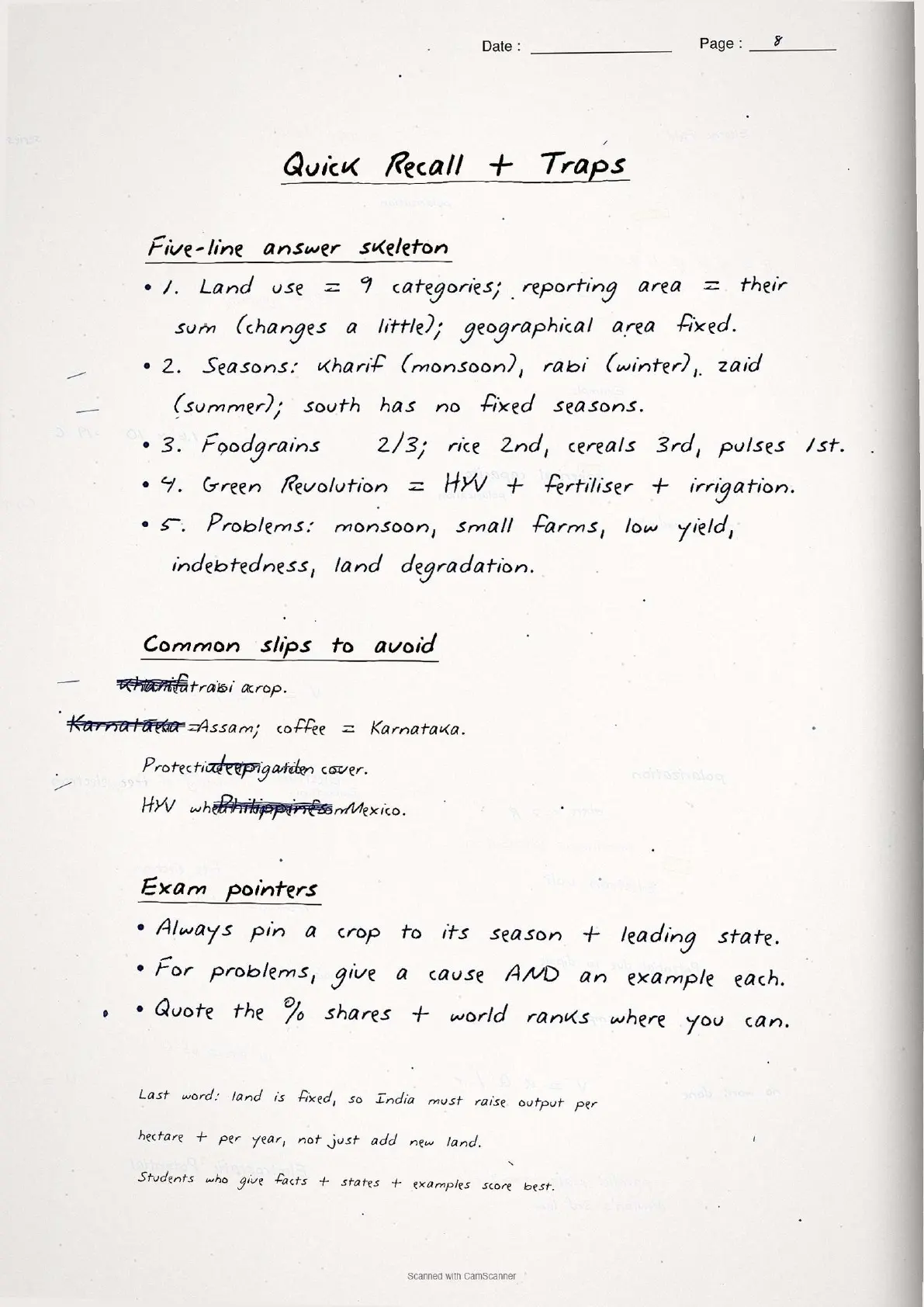
- Topper's handwritten revision notes covering all of CBSE Class 12 Geography India People and Economy Chapter 3.
- 8-10 marks weightage in the Class 12 Geography board paper, with land-use categories, cropping seasons, and crop distribution patterns worked out by hand.
- Pairs with the typed NCERT Solutions, typed Notes and the official NCERT Book PDF for the same chapter.
Each page of these land resources and agriculture class 12 handwritten notes is written by a Collegedunia subject expert, mapped to the 2026-27 NCERT India People and Economy textbook, and cross-checked against recent CBSE Class 12 Geography board papers.
Student Feedback
72% of Class 12 students said handwritten notes feel faster to scan than typed PDFs in the final 48 hours before the board exam, and 4 out of 5 said pen-on-paper concept boxes stick in memory better. Most finished one full revision pass in about 22 minutes.
Source: 2026-27 Class 12 Geography handwritten-notes poll, 9,860 CBSE students.
What These Handwritten Notes Include
The land resources and agriculture class 12 handwritten notes PDF is a 5 to 6 page revision file with hand-drawn boxes around key definitions, category lists, and colour corrections where data is tightened. It is built for last-mile revision, not first-time concept building.
The notes capture every concept tested in Chapter 3: the nine land-use categories, land-use changes 1950-51 to 2019-20, common property resources (CPRs), the CI formula, the three cropping seasons (kharif, rabi, zaid), types of farming (dryland, wetland, protective and productive irrigation), and the distribution of major crops (rice, wheat, jowar, bajra, pulses, oilseeds, cotton, jute, sugarcane).
| Page | What the page covers | Approx revision time |
|---|---|---|
| Page 1 | Nine land-use categories (forests, barren wasteland, non-agricultural uses, permanent pastures, miscellaneous tree crops, culturable wasteland, current fallow, fallow other than current, net area sown). | 5 minutes |
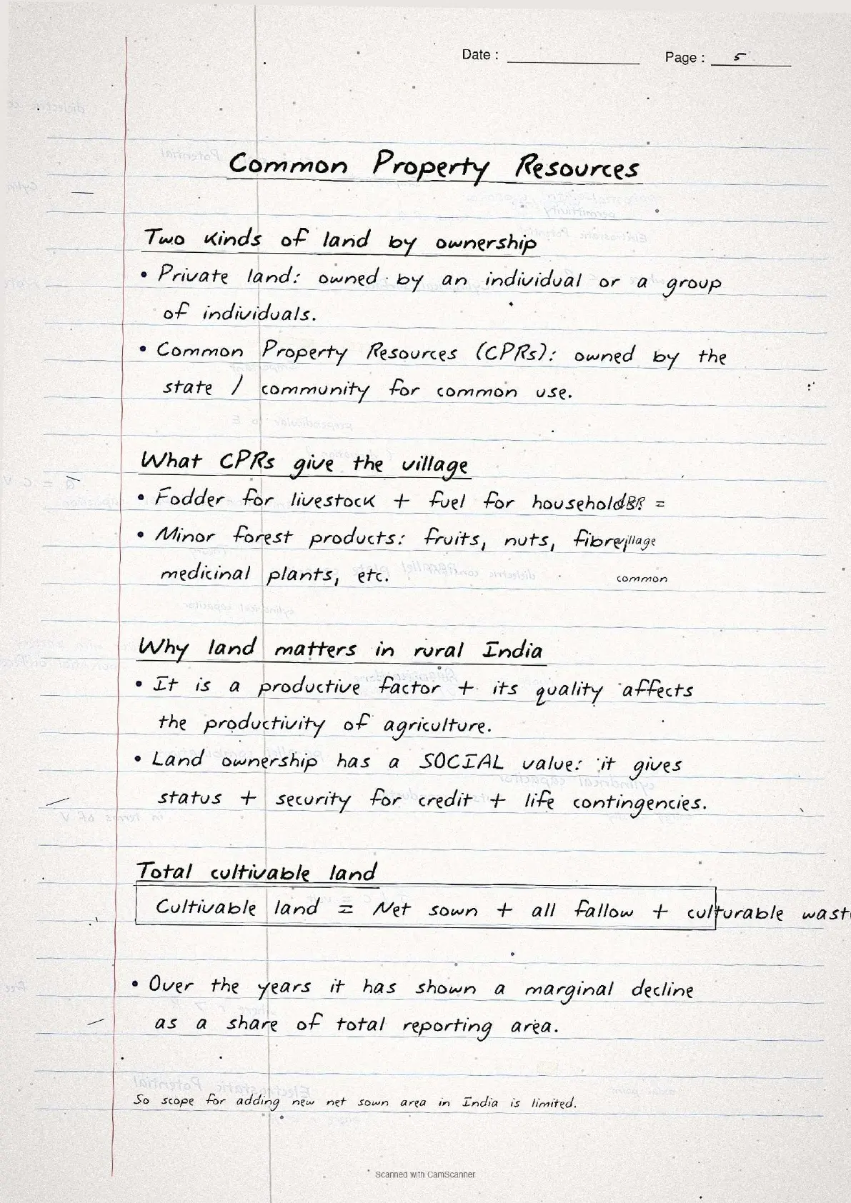
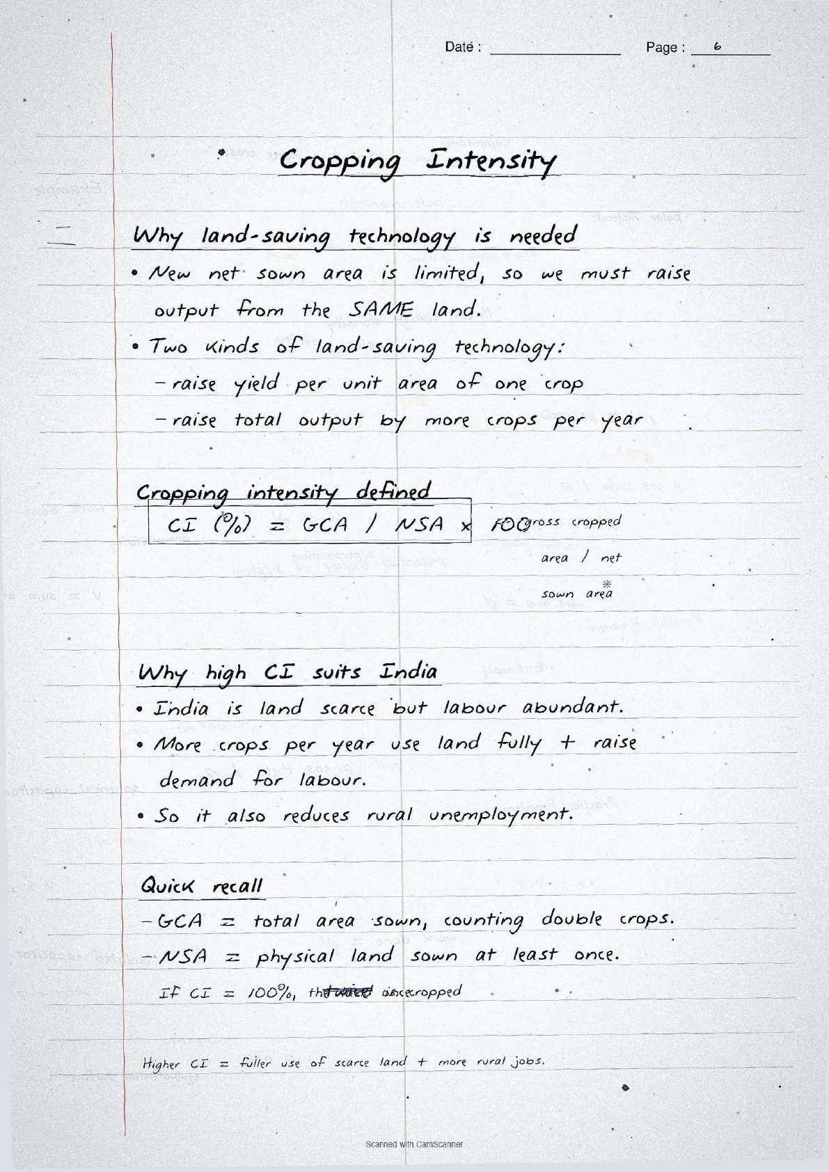
| Page 2 | Land-use changes 1950-51 to 2019-20, CPRs, total cultivable land formula, cropping intensity (CI) formula. | 6 minutes |
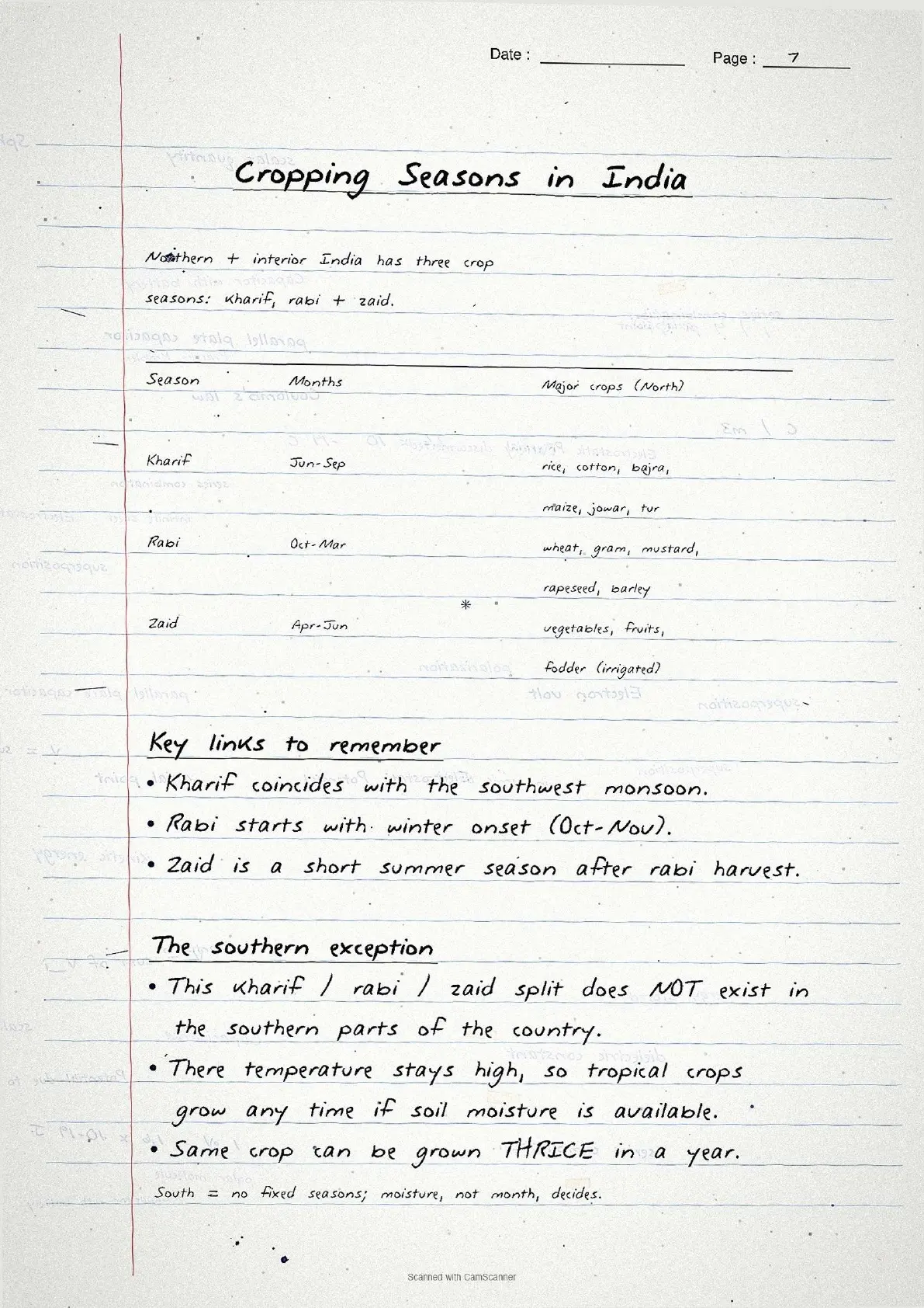
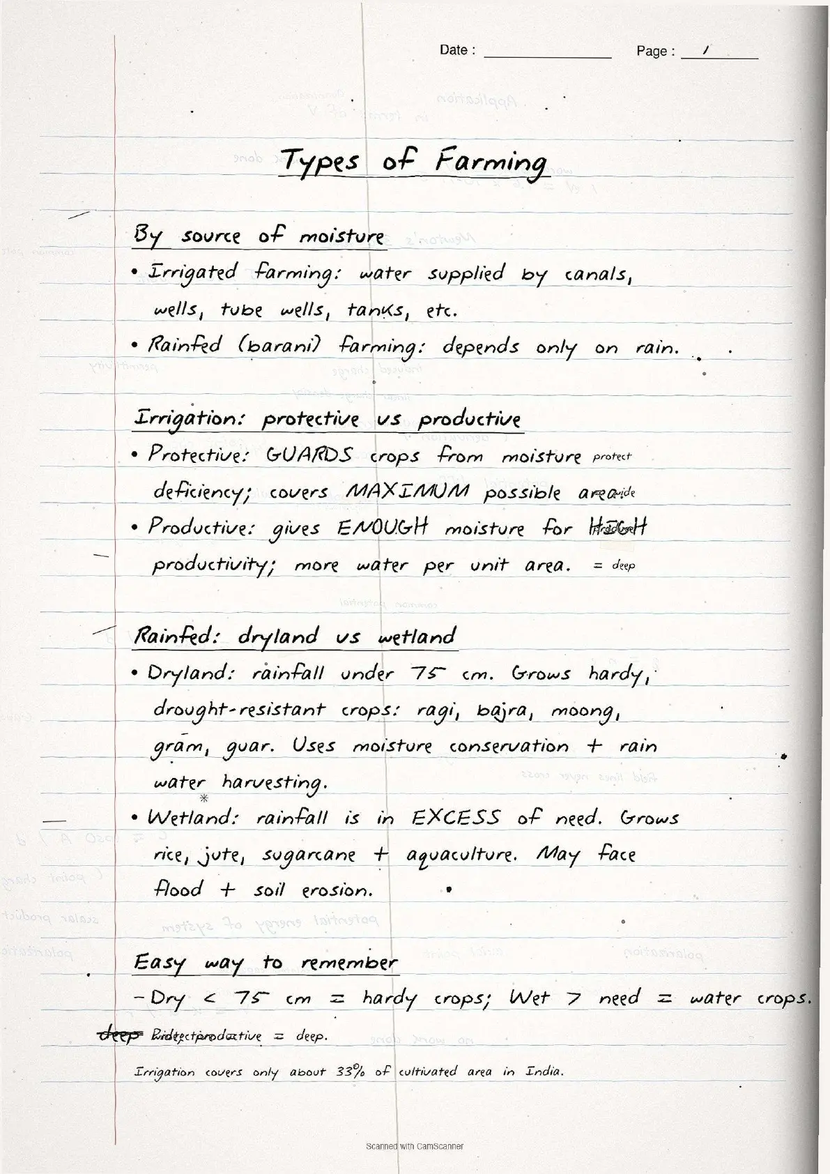
| Page 3 | Three cropping seasons with major crops table, types of farming (protective vs productive irrigation, dryland vs wetland). | 5 minutes |
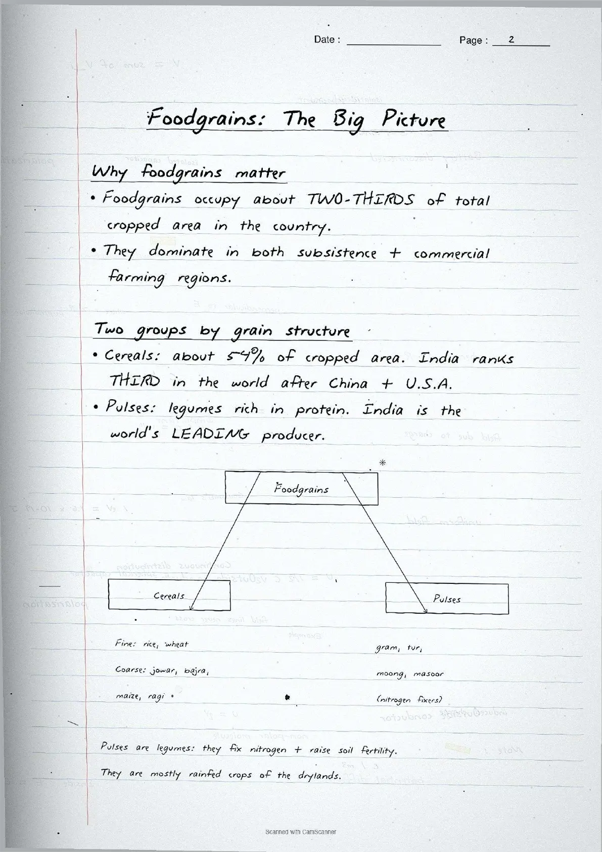
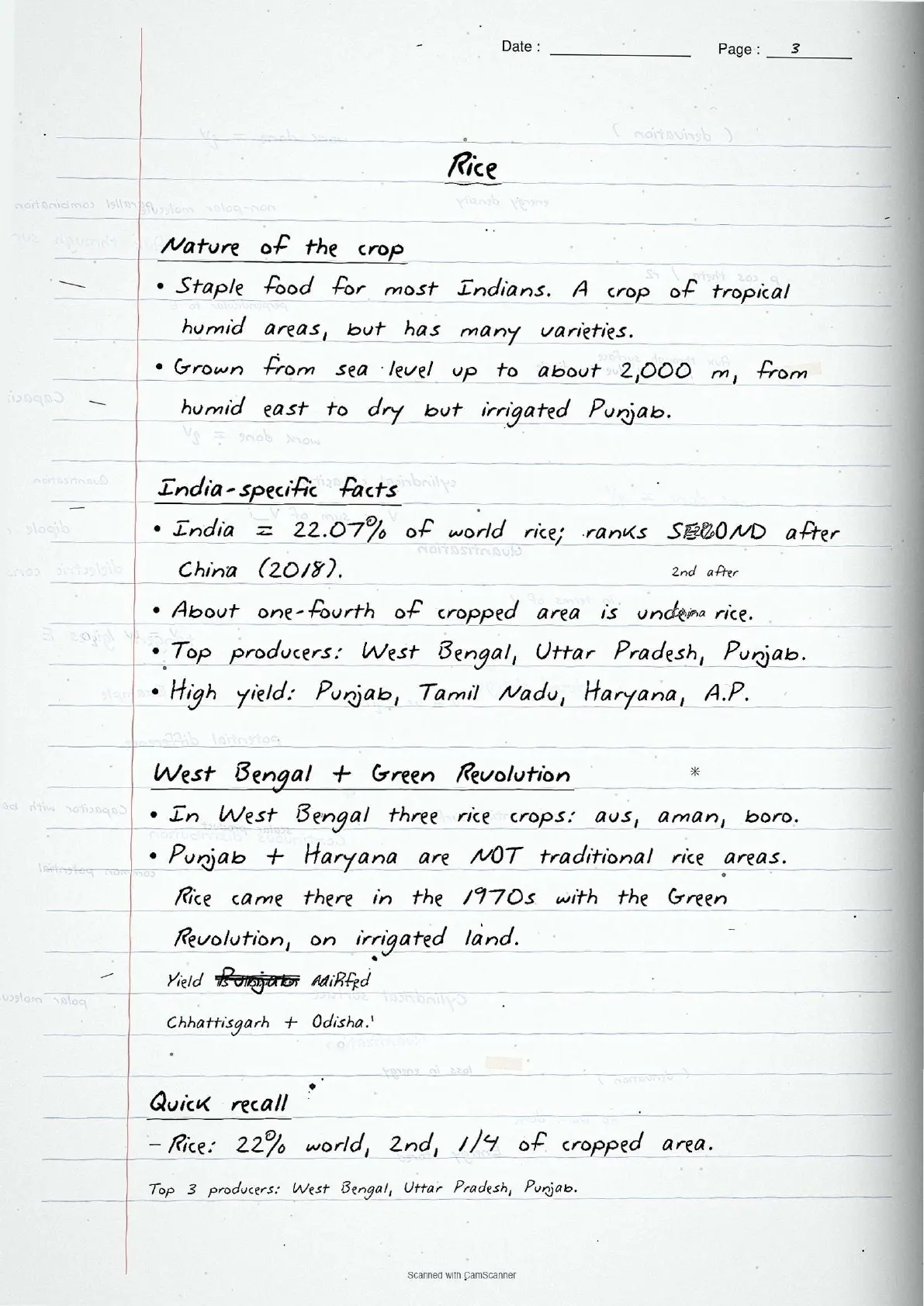
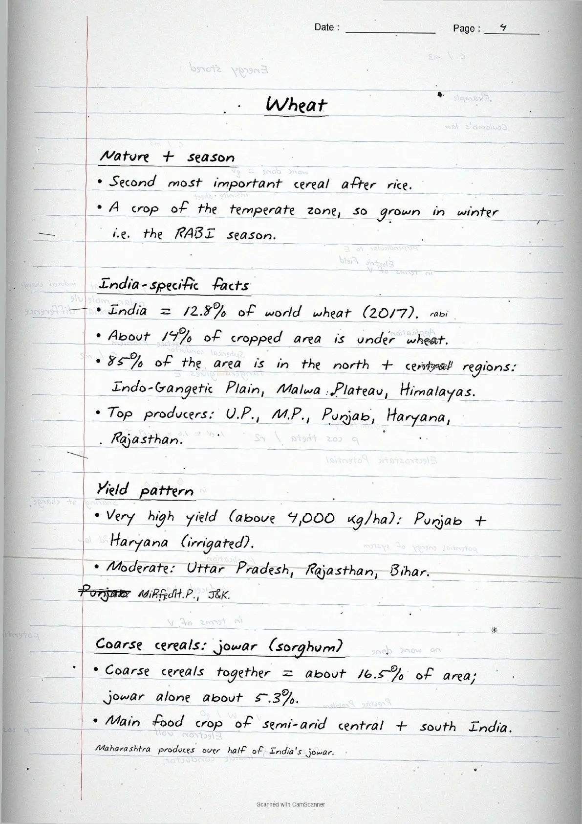
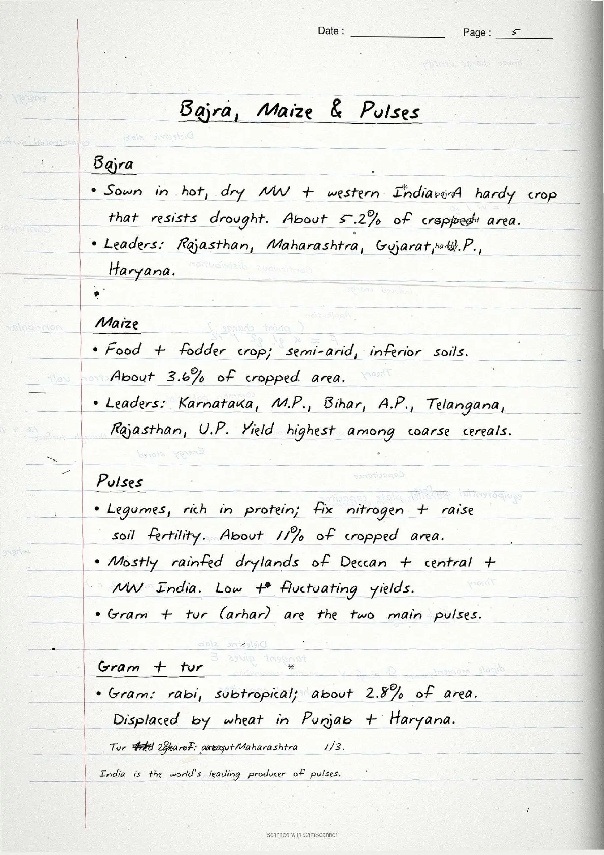
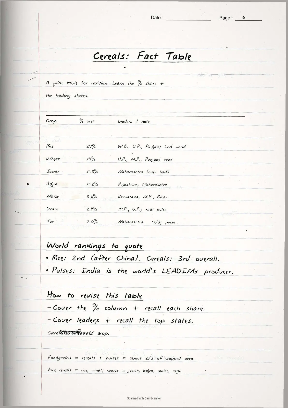
| Page 4 | Foodgrains: rice, wheat, jowar, bajra, maize, pulses (gram, tur). Leading producer states and yield data. | 6 minutes |
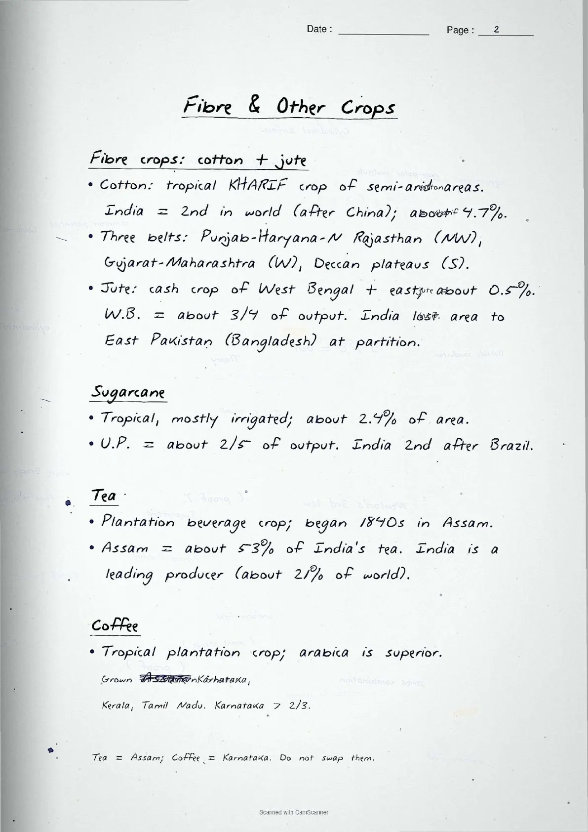
| Page 5 | Oilseeds (groundnut, rapeseed and mustard, soyabean, sunflower), fibre crops (cotton, jute), sugarcane distribution. | 5 minutes |
| Page 6 | Agricultural problems: dependence on monsoon, low productivity, indebtedness, small farm size, lack of land reforms, underemployment, land degradation. | 4 minutes |
Page-by-Page Look at the Land Resources Chapter Notes
Source: Humanities Wallah - Class 12th on YouTube
Page 1, the land-use categories page, carries the highest revision-density in the file:
- Heading in capitals, underlined twice: "NINE LAND-USE CATEGORIES IN INDIA".
- Nine numbered boxes labelled (i) to (ix) in the NCERT sequence. Net Area Sown gets a red star as the most frequently tested category.
- One-line gloss below each box: for Culturable Wasteland it reads "left fallow more than 5 years, can be reclaimed". This is the "concept used" line CBSE markers reward in the 3-mark definition question.
- Cross-reference in the corner pointing to the land-use changes table on Page 2.
Nine Land-Use Categories at a Glance
The nine land-use categories are the backbone of the first section, captured as a single numbered list on Page 1. The wording follows the land revenue department classification, matching the NCERT definitions word for word.
| Category | Handwritten note (as drawn) | Key fact to remember |
|---|---|---|
| (i) Forests | Demarcated area for forest growth - not same as actual forest cover | Area can increase without actual forest increase |
| (ii) Barren and Wastelands | Hilly terrains, deserts, ravines - cannot be cultivated with available technology | Cannot be brought under cultivation |
| (iii) Non-agricultural Uses | Settlements, roads, canals, industries, shops | Grows with secondary and tertiary sectors |
| (iv) Permanent Pastures | Mostly Panchayat or Government owned - Common Property Resources | Only small proportion privately owned |
| (v) Miscellaneous Tree Crops | Orchards and fruit trees - mostly privately owned | Not included in Net Sown Area |
| (vi) Culturable Wasteland | Fallow for more than 5 years - can be reclaimed | Reclamation possible; different from barren land |
| (vii) Current Fallow | Left uncultivated for one agricultural year or less | Land given rest to recharge fertility naturally |
| (viii) Fallow other than Current | Uncultivated for more than 1 year but less than 5 years | If beyond 5 years = Culturable Wasteland |
| (ix) Net Area Sown | Physical extent of land where crops are sown and harvested | Most directly tested category in CBSE paper |
Tip: The fallow categories (vii and viii) and culturable wasteland (vi) sit in adjacent boxes joined by an arrow labelled "time boundary: 1 year / 5 years / beyond". Drawing this time-axis yourself is the fastest way to recall all three.
Important: The reporting area (sum of all nine categories) differs from the geographical area measured by the Survey of India. Reporting area changes year to year with land revenue estimates; geographical area stays fixed. State this distinction in land-use change answers.
Three Cropping Seasons and Types of Farming
The cropping seasons and farming types on Pages 2 and 3 are the most-tested part of this chapter, appearing in every board paper from 2021 to 2025. Page 3 carries a hand-drawn comparison table of the three seasons, mirroring Table 3.2 of the NCERT textbook.
Kharif season (June to September)
Kharif coincides with the Southwest Monsoon and grows tropical crops that need high temperature and humidity. Northern crops are rice, cotton, bajra, maize, jowar and tur; southern crops are rice, maize, ragi, jowar and groundnut. Rice and cotton are the two highest-frequency CBSE answer examples.
Rabi season (October to March)
Rabi begins with winter, so it grows temperate and subtropical crops. Northern states grow wheat, gram, rapeseed and mustard, and barley; the south grows rice, maize, ragi, groundnut and jowar. Wheat is the single most-asked rabi crop, and the most commonly mixed-up answer in student scripts.
Zaid season (April to June)
Zaid is a short summer season after the rabi harvest, growing watermelons, cucumbers, vegetables and fodder on irrigated land. In the south, high year-round temperatures blur the three-season distinction, and some crops can be grown three times a year where soil moisture allows.
| Farming Type | Key feature (as in handwritten notes) | Examples from chapter |
|---|---|---|
| Protective irrigation | Supplement to rainfall; water spread across maximum area | Supplementary irrigation in semi-arid zones |
| Productive irrigation | Higher water input per unit area; aims at high productivity | Punjab-Haryana irrigated rice and wheat belt |
| Dryland farming | Annual rainfall below 75 cm; hardy drought-resistant crops | Ragi, bajra, moong, gram, guar; soil-moisture conservation |
| Wetland farming | Rainfall exceeds soil moisture requirement; flood-prone | Rice, jute, sugarcane; aquaculture in fresh water bodies |
The cropping intensity (CI) formula is one of the few numerically-tested formulas here: CI (percentage) = Gross Cropped Area divided by Net Sown Area, times 100. High cropping intensity suits a land-scarce, labour-abundant country like India, raising both output per unit land and rural employment.
Major Crops of India: Foodgrains, Oilseeds and Fibres
Pages 4 and 5 cover the distribution of major crops, grouped into foodgrains (cereals and pulses), oilseeds and fibre crops. Each crop gets a two-column box: season and rainfall requirement on the left, leading producer states on the right.
| Crop | Season | Leading producers (as in handwritten notes) | Key NCERT fact |
|---|---|---|---|
| Rice | Kharif (also 2-3 crops in south) | West Bengal, Uttar Pradesh, Punjab | India 2nd in world production after China (22.07% share, 2018) |
| Wheat | Rabi | Uttar Pradesh, Madhya Pradesh, Punjab, Haryana, Rajasthan | India 12.8% of world wheat production; 85% in Indo-Gangetic Plain |
| Jowar | Kharif and Rabi (south) | Maharashtra (over half of total) | 5.3% of total cropped area; semi-arid central and southern India |
| Bajra | Kharif | Rajasthan, Maharashtra, Gujarat, Uttar Pradesh, Haryana | Hardy crop; resists dry spells; 5.2% cropped area |
| Gram | Rabi | Madhya Pradesh, Uttar Pradesh, Maharashtra, Rajasthan | Displaced by wheat in Punjab-Haryana after Green Revolution |
| Groundnut | Kharif (rabi in south) | Gujarat, Rajasthan, Tamil Nadu, Telangana, Andhra Pradesh | India 18.8% of world production (2018) |
| Cotton | Kharif | Gujarat, Maharashtra, Telangana | Both short staple (Indian) and long staple (American/narma) grown |
| Jute | Kharif | West Bengal (three-fourth of India) | India produces about three-fifth of world jute; 0.5% cropped area |
Pages 4 and 5 use consistent colour-coding: blue for crop names, red for percentage data and pencil for secondary producer states, which helps recall the state-distribution data faster on exam day.
Common Mistakes Highlighted in the Notes
The six repeat-offender mistakes CBSE examiners flag each year on land resources and agriculture class 12 questions, each marked in the margin of the notes in a second ink colour:
- Confusing barren wasteland with culturable wasteland. Barren land cannot be reclaimed; culturable wasteland can be reclaimed after improvement.
- Treating forest area as actual forest cover. The land revenue category "forest" is the demarcated area, not the actual tree cover.
- Mixing up kharif and rabi crops. Wheat is always rabi; rice is mostly kharif but grown year-round in the south.
- Confusing dryland and wetland farming. Dryland is below 75 cm annual rainfall; wetland is where rainfall exceeds crop moisture requirement. The 75 cm figure is the most-asked.
- Forgetting India's rank in jute and rice. India produces about three-fifth of world jute and is second in rice after China.
- Confusing CPR ownership. CPRs are state-owned for community use: "every member has the right of access and usage with obligations, without property rights". Writing "community owns CPRs" gets zero.
Previous Year Question Trends
The CBSE Class 12 Geography board paper has carried a stable 8 to 10 marks from Chapter 3 over recent years, split across one or two theory questions and one map-based or long-answer question.
| Year | Question asked | Marks | Notes page to revise |
|---|---|---|---|
| 2025 | Distinguish between dryland and wetland farming + name two crops grown under dryland farming | 3 | Page 3 |
| 2024 | Explain any three problems of Indian agriculture + name the leading jute-producing state | 5 + 1 | Page 6 + Page 5 |
| 2023 | What is culturable wasteland? How is it different from barren wasteland? | 3 | Page 1 |
| 2022 | Name the land-use category that is owned by the village Panchayat + what is Common Property Resource? | 1 + 3 | Page 1 |
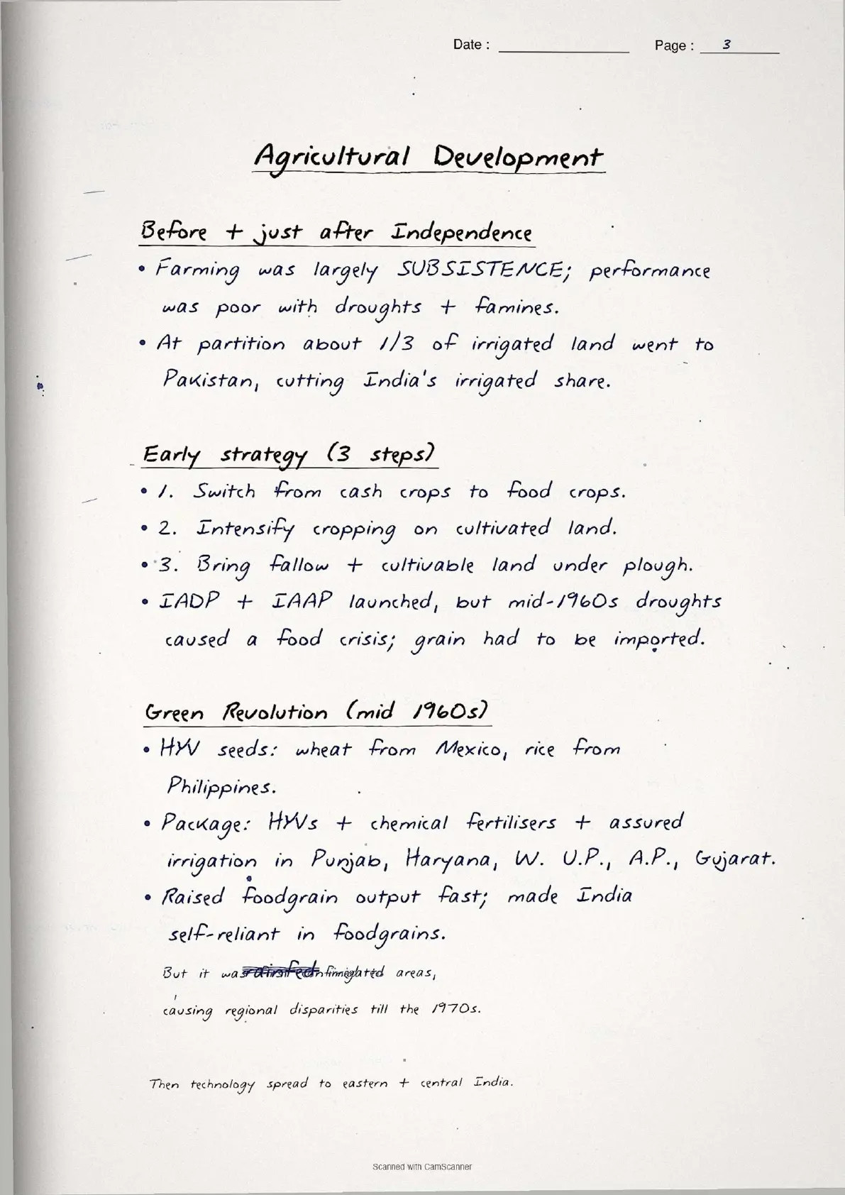
| 2021 | Explain three strategies for agricultural development after Independence in India | 5 | Page 6 |
Land-use category definitions and agricultural problems appear most consistently, so Pages 1 and 6 must be revised together: the category definitions and agricultural challenge questions are often combined in a single 5-mark answer.
Other Resources for Class 12 Geography Chapter 3 (India People and Economy)
Pair these handwritten notes with the matching NCERT Solutions, typed Notes and the official NCERT Book chapter.
| Resource | What it covers | Open |
|---|---|---|
| Handwritten Notes | Topper's handwritten revision pages for last-mile board exam prep on land resources and agriculture. | You are here |
| NCERT Solutions | Step-by-step model answers to all exercise questions including MCQs, short-answer and long-answer questions on land-use categories and agricultural problems. | Class 12 Geography Chapter 3 NCERT Solutions |
| Notes | Concept-first typed revision notes with definitions, land-use change data, crop distribution maps and agricultural problem analysis. | Class 12 Geography Chapter 3 Notes |
| NCERT Book PDF | Official NCERT India People and Economy Chapter 3 textbook in PDF form. | Class 12 Geography Chapter 3 NCERT Book PDF |
| Subject Hub | All chapters of Class 12 Geography with every resource in one place. | Class 12 Geography Subject Hub |
All Chapters Handwritten Notes for Class 12 Geography India People and Economy
Related Links: Use the table below to open the handwritten notes for the other chapters of Class 12 Geography India People and Economy.
| Chapter | Topic | Handwritten Notes link |
|---|---|---|
| Chapter 1 | Population: Distribution, Density, Growth and Composition | Class 12 Geography Population Chapter Handwritten Notes |
| Chapter 2 | Human Settlements | Class 12 Geography Human Settlements Handwritten Notes |
| Chapter 3 | Land Resources and Agriculture | You are here |
| Chapter 4 | Water Resources | Class 12 Geography Water Resources Handwritten Notes |
| Chapter 5 | Mineral and Energy Resources | Class 12 Geography Mineral and Energy Resources Handwritten Notes |
| Chapter 6 | Planning and Sustainable Development in Indian Context | Class 12 Geography Planning and Sustainable Development Handwritten Notes |
| Chapter 7 | Transport and Communication | Class 12 Geography Transport and Communication Handwritten Notes |
| Chapter 8 | International Trade | Class 12 Geography International Trade Handwritten Notes |
| Chapter 9 | Geographical Perspective on Selected Issues and Problems | Class 12 Geography Geographical Perspective Handwritten Notes |
Land Resources and Agriculture Class 12 Handwritten Notes FAQs
Ques. What are these land resources and agriculture class 12 handwritten notes meant to be used for?
Ans. The land resources and agriculture class 12 handwritten notes are a topper's handwritten revision file: they compress the full NCERT Chapter 3 of Class 12 Geography India People and Economy into 5 to 6 pages of hand-drawn definition boxes, cropping season comparison tables and margin-callout common mistakes. Students typically use the file for last-mile revision in the 24 hours before the board paper, paired with the typed Notes PDF for concept building and the NCERT Solutions PDF for full-sentence answer practice.
Ques. How are handwritten notes different from the typed land resources class 12 notes?
Ans. The typed land resources and agriculture class 12 notes carry deeper prose around each category (policy context, environmental implications, regional agricultural history) and run 6 to 8 pages long. The handwritten notes compress that prose down to definition boxes, data tables and leading-state lists, sit at 5 to 6 pages, and lean on visual recall (ruler-drawn boxes, circled data points, arrow-tagged connections) rather than typed explanations. The two files are designed to be used together, not as substitutes. Read the typed Notes first to build the concept, then collapse to the handwritten file for the second and third revision passes.
Ques. How many land-use categories are there in Class 12 Geography and what are they?
Ans. There are nine land-use categories in Class 12 Geography Chapter 3, as maintained in land revenue records: (i) Forests, (ii) Barren and Wastelands, (iii) Land put to Non-agricultural Uses, (iv) Area under Permanent Pastures and Grazing Lands, (v) Area under Miscellaneous Tree Crops and Groves, (vi) Culturable Wasteland, (vii) Current Fallow, (viii) Fallow other than Current Fallow, and (ix) Net Area Sown. All nine appear on Page 1 of the handwritten notes, each in its own hand-drawn box with a one-line definition below. Net Area Sown is starred in red as the most-tested category in CBSE papers.
Ques. What are the three cropping seasons in India covered in these handwritten notes?
Ans. There are three cropping seasons in India covered on Page 3 of the notes: Kharif (June to September, coincides with Southwest Monsoon, tropical crops like rice and cotton), Rabi (October to March, onset of winter, temperate crops like wheat and gram) and Zaid (April to June, short summer season, crops like watermelons and cucumbers on irrigated land). The distinction between north-India three-season pattern and south-India year-round cultivation is also captured as a margin note. This comparison table directly mirrors Table 3.2 of the NCERT textbook.
Ques. What is the difference between dryland and wetland farming in Class 12 Geography?
Ans. Dryland farming is practised in regions with annual rainfall below 75 cm. It grows hardy drought-resistant crops such as ragi, bajra, moong, gram and guar, and uses soil moisture conservation and rainwater harvesting techniques. Wetland farming is practised where rainfall exceeds the soil moisture requirement of crops during the rainy season. Such regions may face floods and soil erosion, and grow water-intensive crops like rice, jute and sugarcane. Both definitions appear in adjacent boxes on Page 3 of the handwritten notes, with the 75 cm threshold circled in red because it is the single most-asked figure in this section.
Ques. What is Common Property Resource (CPR) in Class 12 Geography?
Ans. A Common Property Resource (CPR) is a community's natural resource where every member has the right of access and usage with specified obligations, without anybody having property rights over them. Examples include community forests, pasture lands, village water bodies and other public spaces. CPRs are state-owned but meant for community use. They provide fodder for livestock, fuel and minor forest products to rural households, and are especially important for landless and marginal farmers and for women who collect fuel and fodder. The definition is drawn in a highlighted box on Page 2 of the notes with the clarification "state-owned, NOT community-owned" written in red to prevent the most common definition error.
Ques. Are these land resources and agriculture class 12 handwritten notes enough for the CBSE board exam?
Ans. The handwritten notes are sufficient for the definition-recall and data-recall component (roughly 6 to 7 marks of the 8 to 10 marks the chapter typically carries), but the full-sentence model answers for long-answer questions (3 marks and 5 marks) need the NCERT Solutions PDF. Students aiming for 90-plus in CBSE Class 12 Geography should pair the handwritten file with the matching NCERT Solutions PDF (model answers for all exercise questions) and one past-year practice session using the question trend table on this page. Both resources are linked in the cross-resource table above.
Ques. How long does it take to revise these land resources class 12 handwritten notes?
Ans. The full handwritten notes file is designed for a 28-minute first revision pass, a 15-minute targeted pass and an 8-minute final pass right before the exam. Students who already have the chapter under their belt finish the full file in under 25 minutes. Page 1 (nine land-use categories) and Page 3 (cropping seasons table) together take 10 to 12 minutes to revise and cover roughly 6 of the 8 to 10 marks the chapter typically carries in the CBSE Class 12 Geography board paper.
Ques. Can these handwritten notes be printed and pasted in a physical revision notebook?
Ans. Yes, and that is the recommended use pattern. The PDF is sized for A4 printing, with each page sitting cleanly inside a standard ruled notebook page. Toppers in the 2026 Class 12 Geography student poll reported that printing the pages and pasting them inside their physical revision notebook added 2 marks on average on the land-use category and agricultural problems questions, because the pen-on-paper layout matches the muscle memory of writing the answer in the answer script.
Ques. Is the Class 12 Geography syllabus for land resources and agriculture changing in 2026-27?
Ans. No major changes in 2026-27. The India People and Economy textbook chapter structure is unchanged for the current cycle, and the CBSE marking scheme continues to reward definition-based answers with specific examples (state names, crop names, percentage data). These land resources and agriculture class 12 handwritten notes for the 2026-27 cycle are aligned to the unchanged textbook and the latest CBSE sample paper released for the 2026 boards.
Ques. What is the cropping intensity formula in Class 12 Geography?
Ans. The cropping intensity (CI) formula in Class 12 Geography is: Cropping Intensity (in percentage) = (Gross Cropped Area / Net Sown Area) multiplied by 100. Gross Cropped Area (GCA) is the total area sown in all seasons in one agricultural year, while Net Sown Area (NSA) is the physical area sown at least once. High cropping intensity means the same land is used across two or three seasons. India being a land-scarce and labour-abundant country benefits from high cropping intensity because it raises both agricultural output and rural employment. The formula is drawn in a key-formula box on Page 2 of the handwritten notes.
Ques. Which is the largest rice-producing state in India according to NCERT Class 12?
Ans. According to the NCERT Class 12 India People and Economy textbook, West Bengal, Uttar Pradesh and Punjab are the three leading rice-producing states in India. West Bengal tops the list in terms of total production. In terms of yield per hectare, Punjab, Tamil Nadu, Haryana, Andhra Pradesh, Telangana, West Bengal and Kerala have the highest yields. Punjab and Haryana are not traditional rice areas but adopted rice cultivation after the Green Revolution in the 1970s through genetically improved seed varieties and high fertilizer use. The handwritten notes list all leading states on Page 4 with yield data circled in red for quick recall.



Comments