




Inside these Class 12 Geography Chapter 7 Transport and Communication notes you get every NCERT definition, the five modes of transport (road, rail, water, air and pipelines), the major sea routes and trans-continental railways, and the full arc from telegraph to cyberspace, all aligned to the 2026-27 syllabus. The file is built to take students from a cold start back to chapter-fluency in about half an hour the night before the exam.

- Concept-first revision for the entire chapter: what transport networks are, how the five modes compare, and which sea routes and trans-continental railways CBSE and CUET examiners pick most often.
- All key definitions, comparative tables for land and water transport, and the communication arc from telegram to satellite to cyberspace that CBSE, CUET and UPSC examiners repeatedly test.
- Cross-pointers to the matching NCERT Solutions, Handwritten Notes and NCERT Book PDF, so students see exactly where each concept gets applied in a worked answer.
These notes are written by Collegedunia geography experts, mapped to the 2026-27 NCERT Fundamentals of Human Geography textbook and the last five years of CBSE and CUET question patterns.
Student Feedback
71% of Class 12 students said matching the five major sea routes to the correct ocean was the most-confused area, and 3 out of 4 rated the transport-mode comparison as the part most worth revising. Most finished a full revision from these notes in about 28 minutes.
Source: 2026-27 Class 12 Geography student poll, 9,450 CBSE students.
Quick Concept Recap: Transport and Communication at a Glance
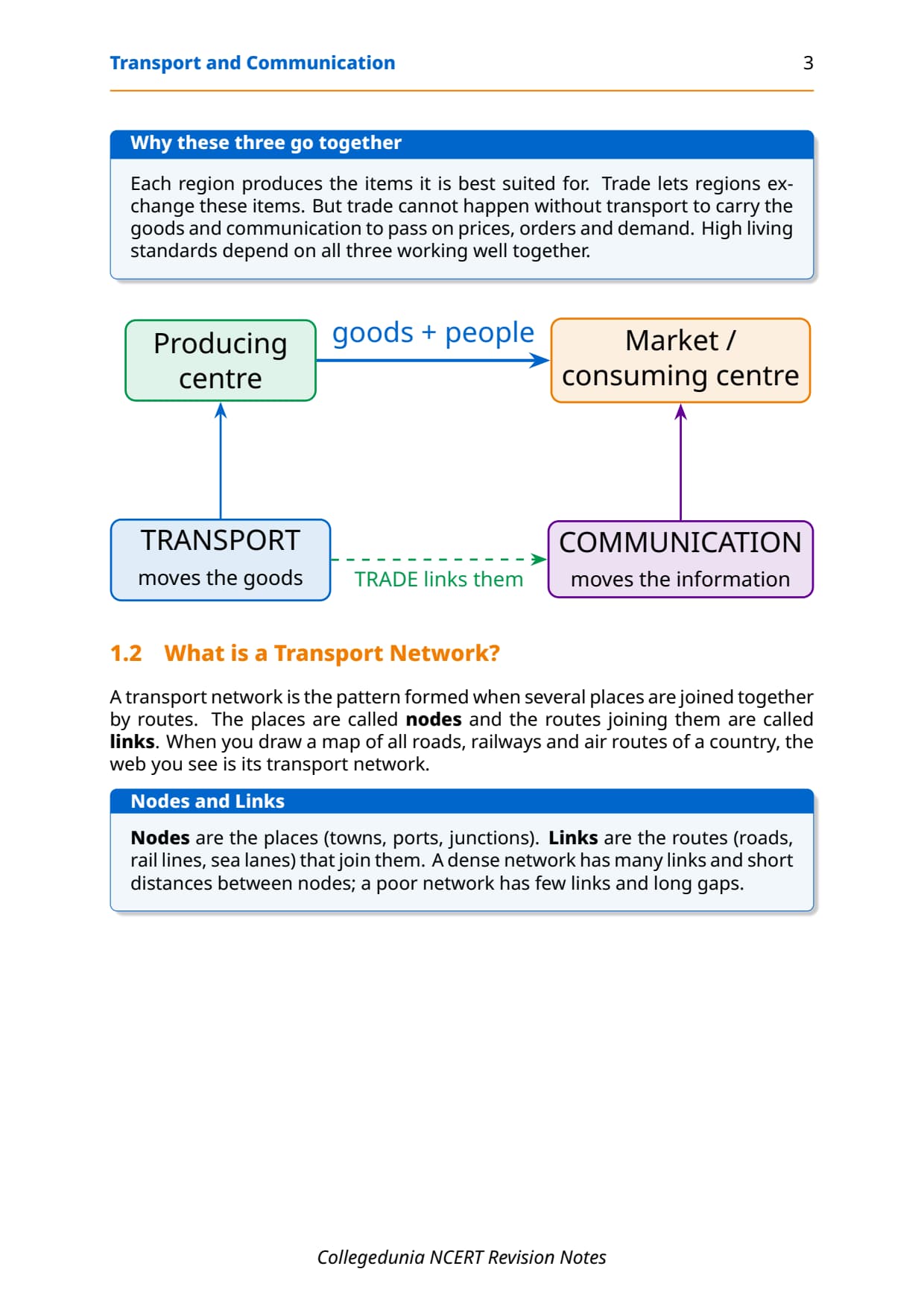
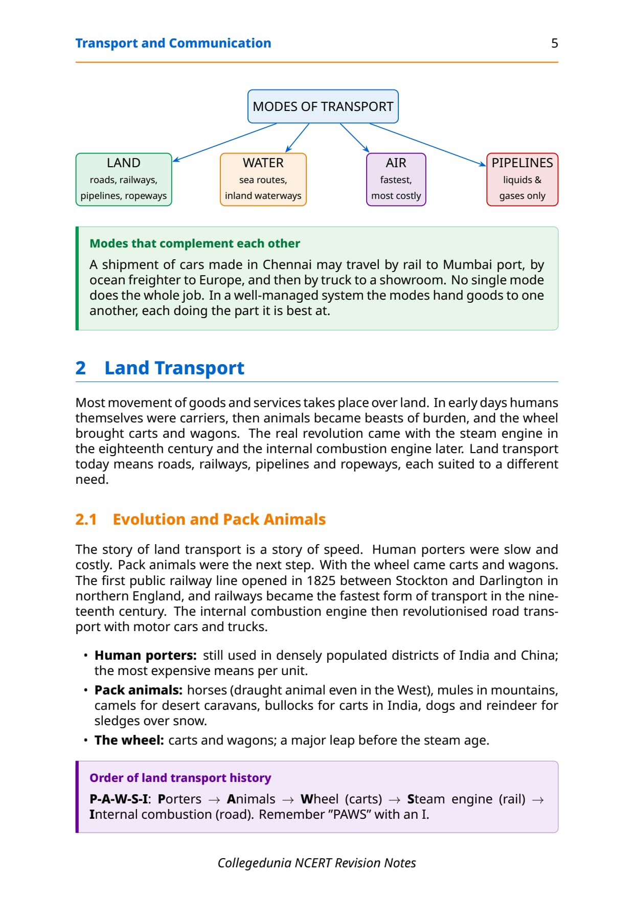
Chapter 7 explains how the world's producing centres and consuming centres get connected. Transport moves goods and people; communication moves information. The five principal modes are land (roads and railways), water (sea routes and inland waterways), air, and pipelines, each suited to different cargo, distances and cost. The tables below carry the key sea routes, trans-continental railways and the communication arc from telegraph to cyberspace.
Read these notes first, then use the matching NCERT Solutions for Class 12 Geography Chapter 7 for the exercise drill.
Source: HUMAN-AT-EASE on YouTube
Key Definitions for Transport and Communication Class 12
Every theory question on this chapter begins with a definition. The terms below are written in the one-line form CBSE markers expect.
| Term | One-line definition | NCERT section pointer |
|---|---|---|
| Transport | A service or facility for the carriage of persons and goods from one place to another using humans, animals and various kinds of vehicles over land, water and air. | Chapter 7 intro |
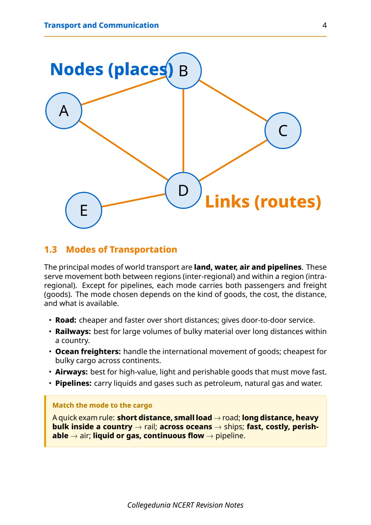
| Transport Network | Several places (nodes) joined together by a series of routes (links) to form a pattern; the basic spatial structure of all transport systems. | What is a Transport Network box |
| Highway | A metalled road about 80 m wide with separate lanes, bridges, flyovers and dual carriageways built for fast, unobstructed long-distance vehicular movement. | Highways section |
| Border Roads | Roads laid along international boundaries that connect remote border villages and military camps to major cities, serving both national integration and defence purposes. | Border Roads section |
| Trans-Continental Railway | A railway line that runs across an entire continent linking its two ends, constructed for economic and political reasons to facilitate long-haul transport across different directions. | Trans-Continental Railways section |
| Sea Route | An ocean pathway regularly used by merchant ships to carry goods and passengers between ports on different continents; determined by ocean currents, wind patterns and port locations. | Sea Routes section |
| Big Trunk Route | The Northern Atlantic Sea Route between North-eastern USA and North-western Europe; the busiest sea route in the world, carrying roughly one-fourth of all global foreign trade. | Northern Atlantic Sea Route section |
| Inland Waterway | A river, canal, lake or coastal stretch used for domestic cargo and passenger movement; navigability depends on channel depth, width and continuity of water flow. | Inland Waterways section |
| Pipeline | A mode of transport that uses continuous underground or surface pipes to move liquids and gases such as petroleum, natural gas and water without interruption. | Pipelines section |
| Satellite Communication | A communication system that uses artificial satellites in Earth's orbit to relay signals and connect distant locations; it makes the unit cost of communication independent of distance. | Satellite Communication section |
| Cyberspace (Internet) | The world of electronic computerised space encompassed by the Internet, allowing information exchange and communication without physical movement of sender or receiver. | Cyber Space section |
| Optic Fibre Cable (OFC) | A cable that transmits data as pulses of light; allows large quantities of data to be sent rapidly, securely and virtually error-free; first major breakthrough in modern telecommunications. | Communications section |
These twelve definitions cover most of the one-mark and 3-mark theory questions CBSE has asked since 2021, so learn them first.
Land Transport: Roads, Highways and Railways
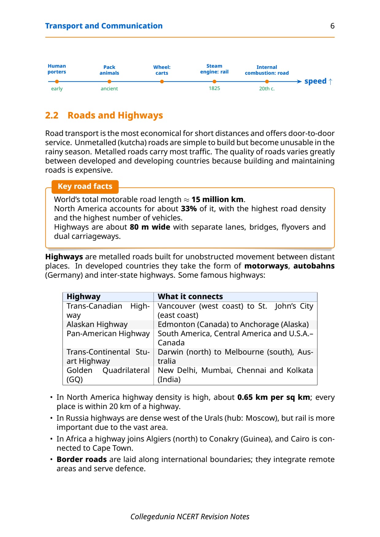
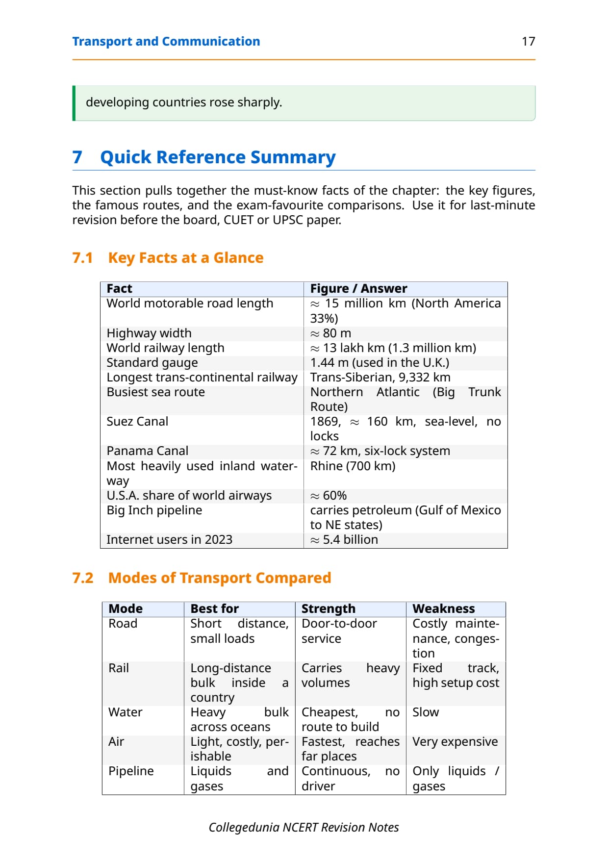
Most movement of goods and people takes place over land. Road transport is most economical for short distances and offers door-to-door service; highways are metalled roads about 80 m wide. North America has the highest road density at about 0.65 km per sq km. Key long-distance roads to remember: the Trans-Canadian Highway (Vancouver to St. John's), the Alaskan Highway (Edmonton to Anchorage), the Pan-American Highway, Australia's Stuart Highway (Darwin to Melbourne) and India's Golden Quadrilateral (Delhi, Mumbai, Chennai, Kolkata).
| Road Type | Key feature | NCERT example |
|---|---|---|
| Motorways / Autobahns | Long-distance, high-speed links in developed countries; Germany's autobahns are the global reference. | Western Europe, North America |
| National Highways | Link major cities; quality varies between developed and developing countries. | India's Golden Quadrilateral |
| Border Roads | Along international boundaries for defence and remote-area connectivity. | India-China borders; most nations |
| Unmetalled Roads | Simple, low-cost, but unmotorable in rainy season; common in developing regions. | Rural India, sub-Saharan Africa |
Railways
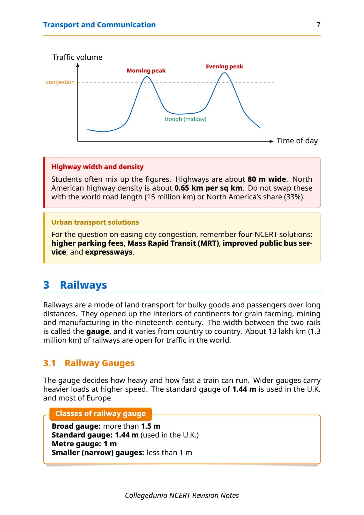
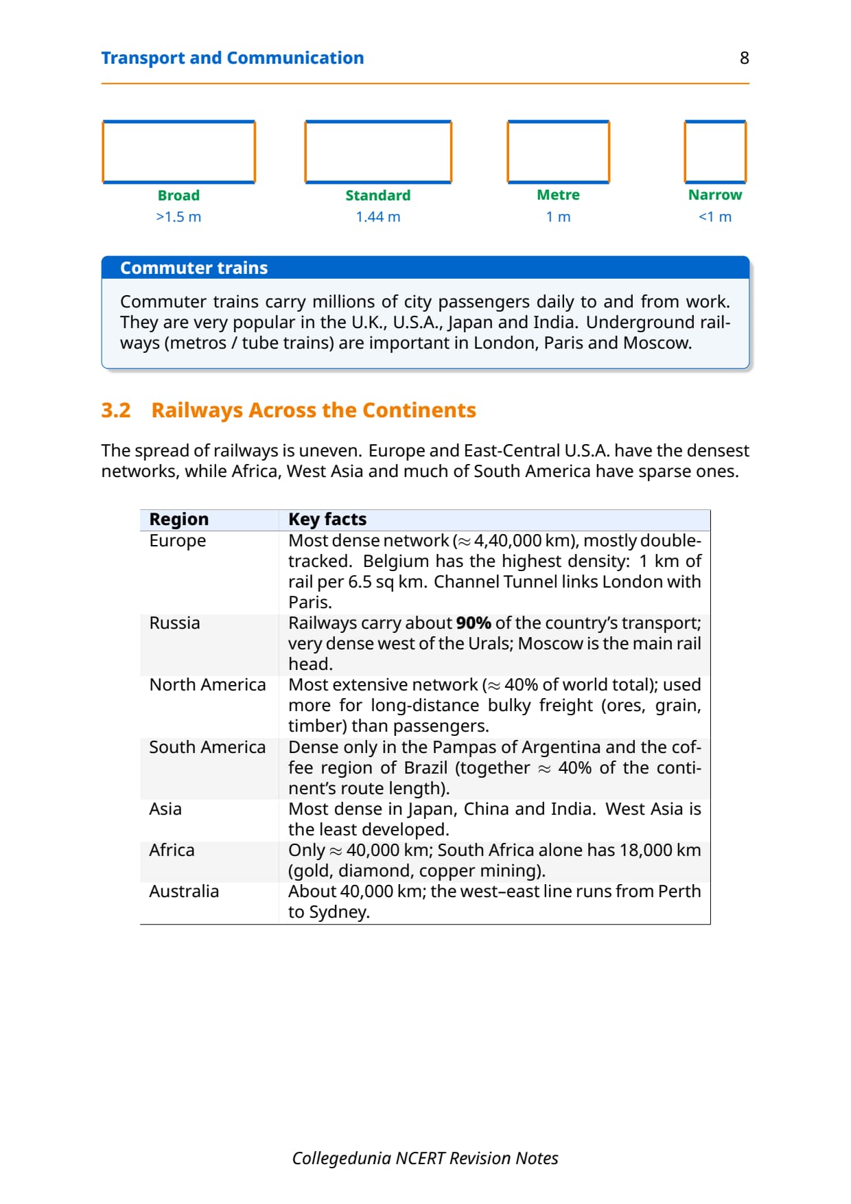
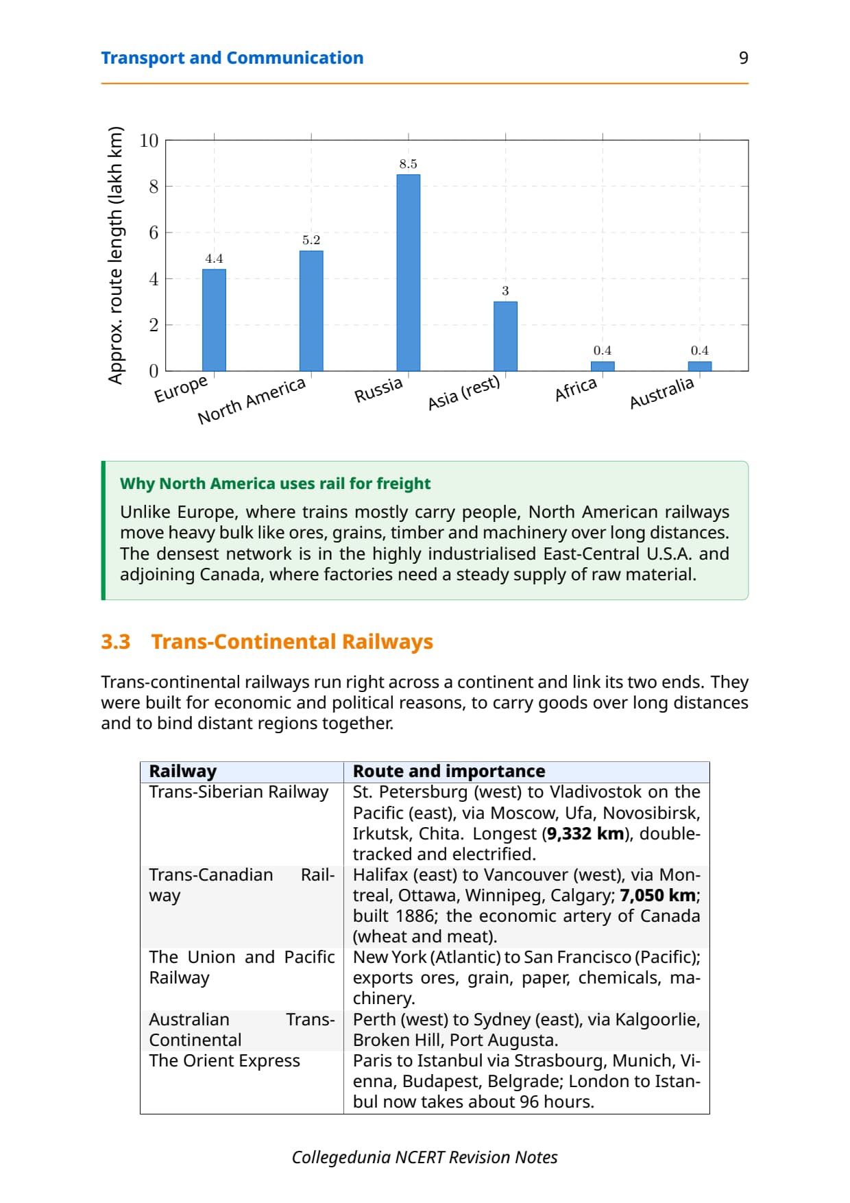
Railways are best for bulky goods and long-distance passengers. There are about 13 lakh km of railways worldwide, and Belgium has the highest railway density (1 km per 6.5 sq km). North America has nearly 40% of the world total (mainly bulk freight); in Russia railways carry about 90% of transport with Moscow as hub; Africa has only 40,000 km, of which South Africa has 18,000 km. The Channel Tunnel links London and Paris. On gauges, note Broad (over 1.5 m, India's main), Standard (1.44 m, UK) and Metre (1 m).
Trans-Continental Railways: Quick Reference Table
Trans-continental railway questions appear in CBSE and CUET almost every year. The table below covers all five lines with the data points examiners pick most.
| Railway Line | From | To | Key fact / CBSE pick |
|---|---|---|---|
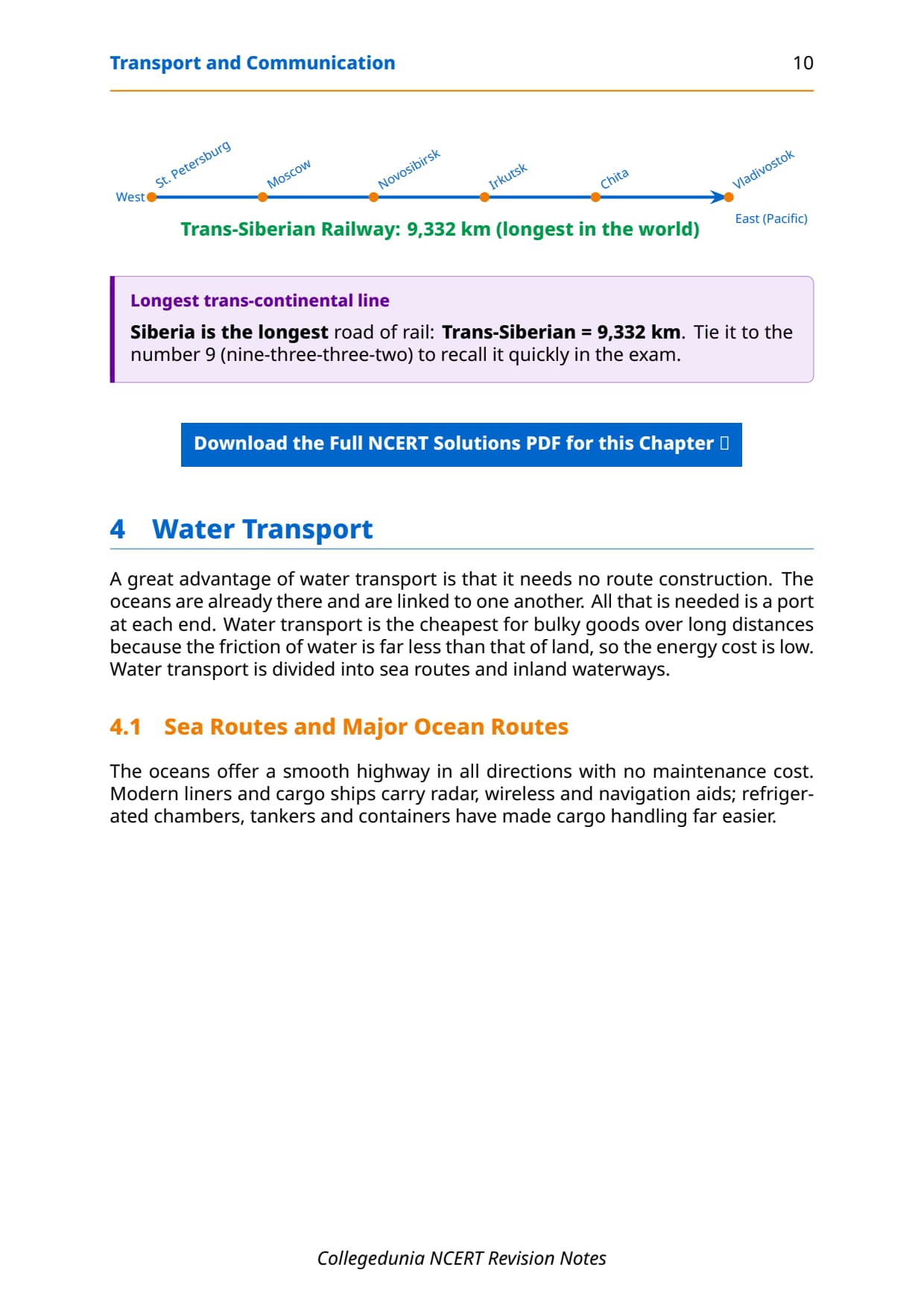
| Trans-Siberian Railway | St. Petersburg (west) | Vladivostok (Pacific coast) | World's longest at 9,332 km; fully double-tracked and electrified; passes through Moscow, Ufa, Novosibirsk, Irkutsk, Khabarovsk. |
| Trans-Canadian Railway | Halifax (east coast) | Vancouver (Pacific coast) | 7,050 km; built in 1886; economic artery linking Quebec-Montreal industrial region with Prairie wheat belt; wheat and meat are key exports. |
| Union and Pacific Railway | New York (Atlantic coast) | San Francisco (Pacific coast) | Connects east and west USA; key exports: ores, grain, paper, chemicals and machinery. |
| Australian Trans-Continental Railway | Perth (west coast) | Sydney (east coast) | Runs through Kalgoorlie, Broken Hill and Port Augusta; separate north-south line connects Adelaide to Alice Springs. |
| Orient Express | Paris | Istanbul | Passes through Strasbourg, Munich, Vienna, Budapest and Belgrade; London to Istanbul in 96 hours vs 10 days by sea; exports: cheese, bacon, oats, wine, fruits and machinery. |
Tip: The Trans-Siberian Railway is the most-tested line. Always state the route (St. Petersburg to Vladivostok), length (9,332 km) and that it is double-tracked and electrified to earn full marks.
Water Transport: Sea Routes and Inland Waterways
Water transport needs no route construction because oceans are naturally interconnected, and it is the cheapest mode for bulky goods over long distances. The chapter divides it into sea routes and inland waterways, and students need both for board and CUET questions.
Five Major Sea Routes
| Sea Route | Ocean / Region | Key detail |
|---|---|---|
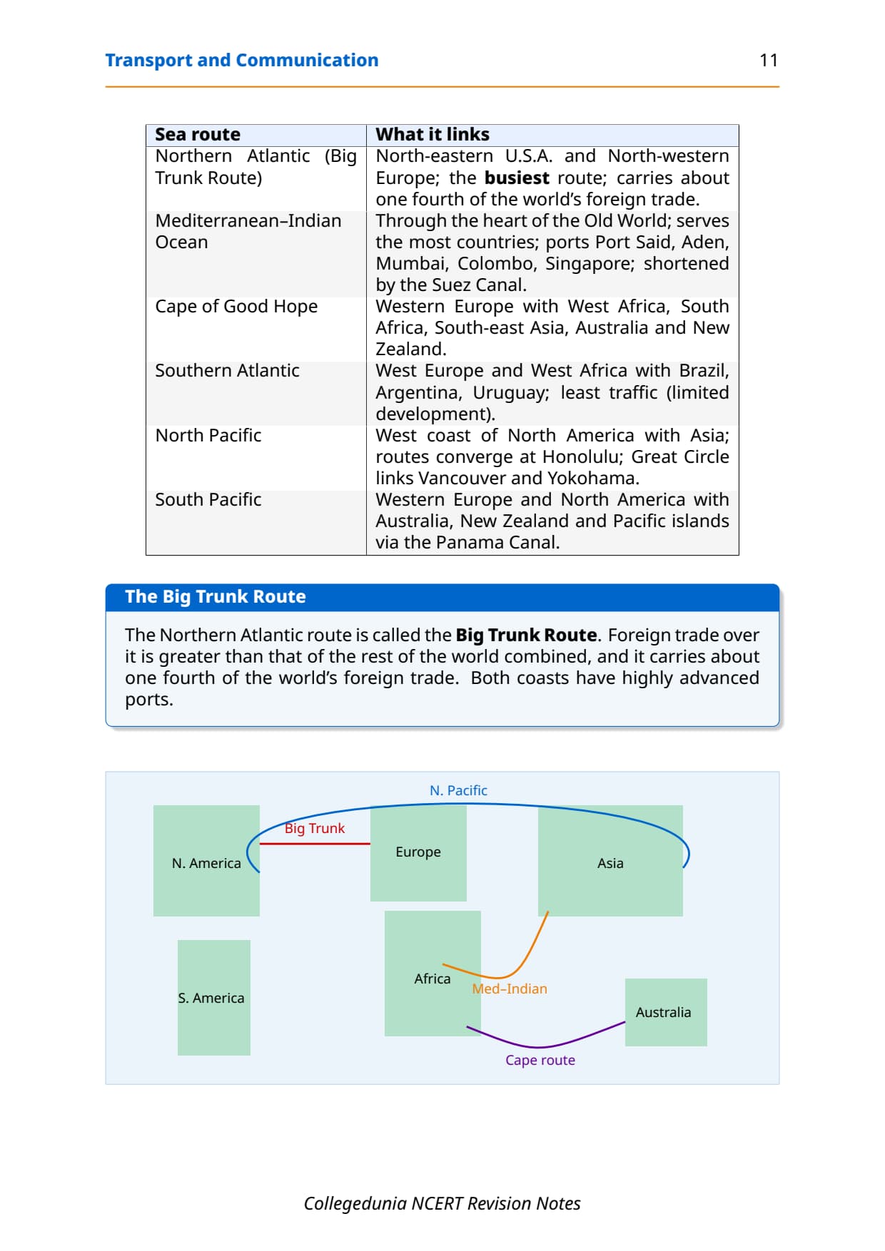
| Northern Atlantic (Big Trunk Route) | North Atlantic Ocean | North-eastern USA to North-western Europe; busiest in the world; one-fourth of all global foreign trade moves on this route. |
| Mediterranean-Indian Ocean Route | Mediterranean Sea to Indian Ocean | Passes through Port Said, Aden, Mumbai, Colombo and Singapore; serves the most countries; Suez Canal shortens distance vs Cape of Good Hope. |
| Cape of Good Hope Route | South Atlantic / Indian Ocean | Western Europe to West Africa, South Africa and South-east Asia / Australia; traffic grows as West and East Africa develop their natural resources. |
| South Atlantic Route | South Atlantic Ocean | West Europe and West Africa to Brazil, Argentina and Uruguay; limited traffic because South America and Africa have similar resources. |
| North Pacific Route | North Pacific Ocean | West coast of North America (Vancouver, Seattle, San Francisco, LA) to Asian ports (Yokohama, Kobe, Shanghai, Hong Kong, Singapore); several routes converge at Honolulu. |
Shipping Canals and Inland Waterways
- Suez Canal: 1869, Egypt; 160 km, sea-level, no locks; links Mediterranean (Port Said) to Red Sea; saves the Cape of Good Hope distance for Europe-Asia trade.
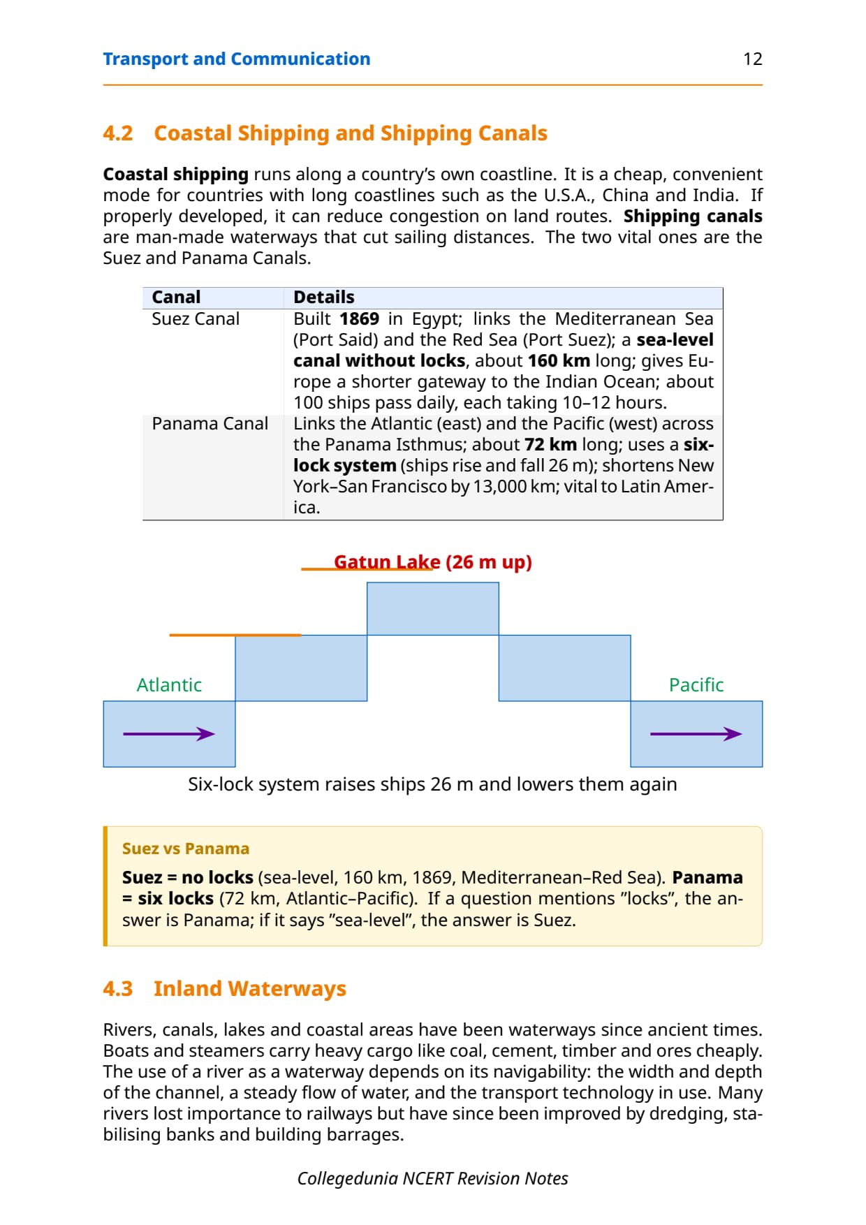
- Panama Canal: links Atlantic to Pacific through the Panama Isthmus; about 72 km with a six-lock system; shortens New York to San Francisco by 13,000 km.
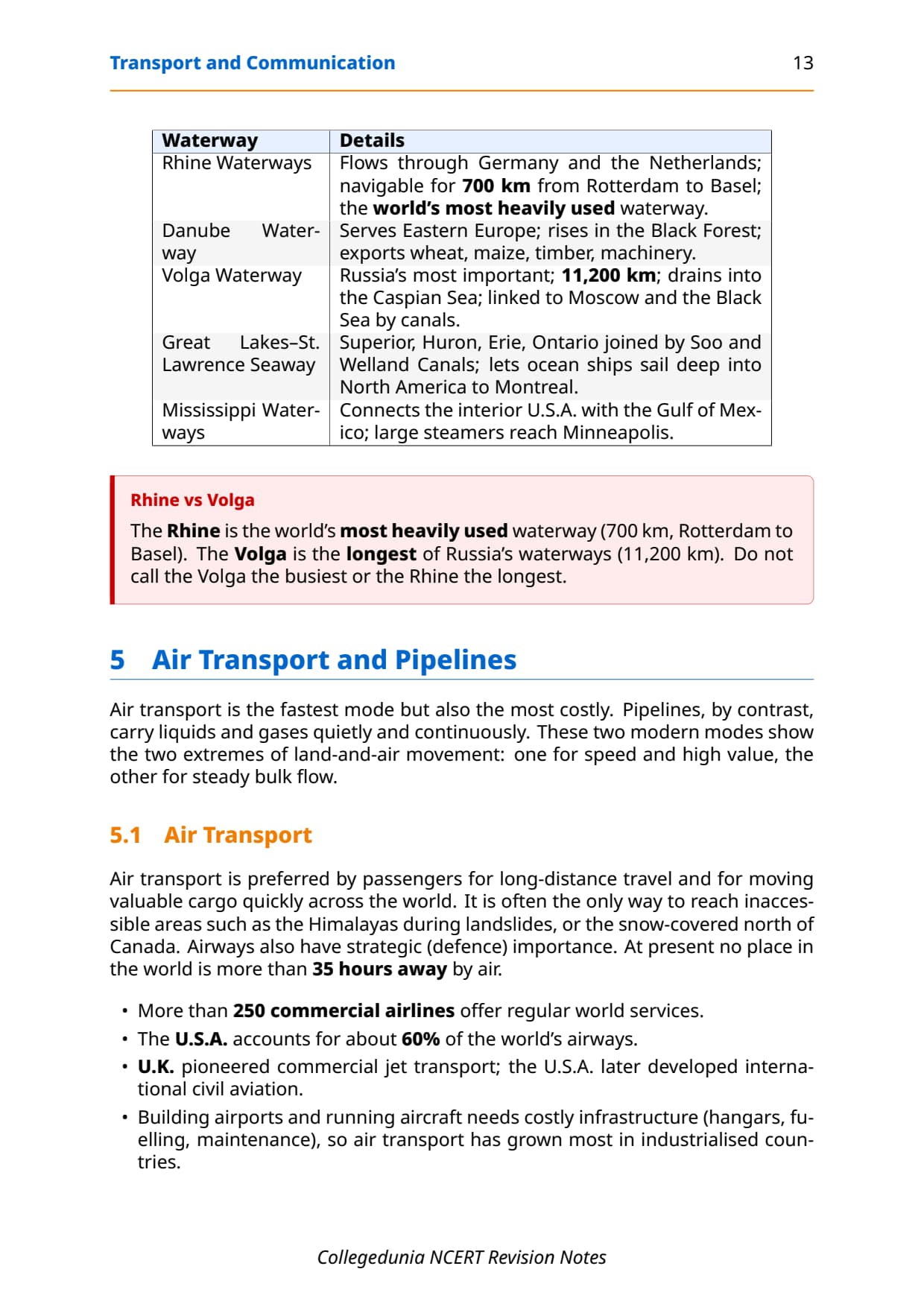
- Rhine Waterway: world's most used inland waterway; 700 km navigable from Rotterdam to Basel.
- Volga Waterway: 11,200 km, drains to the Caspian Sea; Great Lakes-St. Lawrence Seaway lets ocean vessels reach Montreal; the Mississippi-Ohio system links the US interior to the Gulf of Mexico.
Air Transport and Pipelines
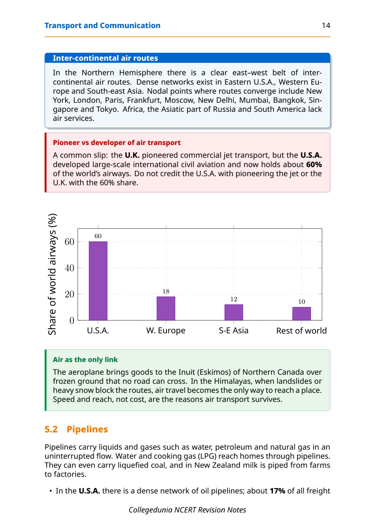
Air transport is the fastest but costliest mode, preferred for long-distance passengers and valuable or perishable cargo. No place on Earth is more than 35 hours away by air. The USA alone accounts for 60% of world airways; dense networks lie in Eastern USA, Western Europe and South-east Asia, while Africa, Asiatic Russia and South America lack regular services.
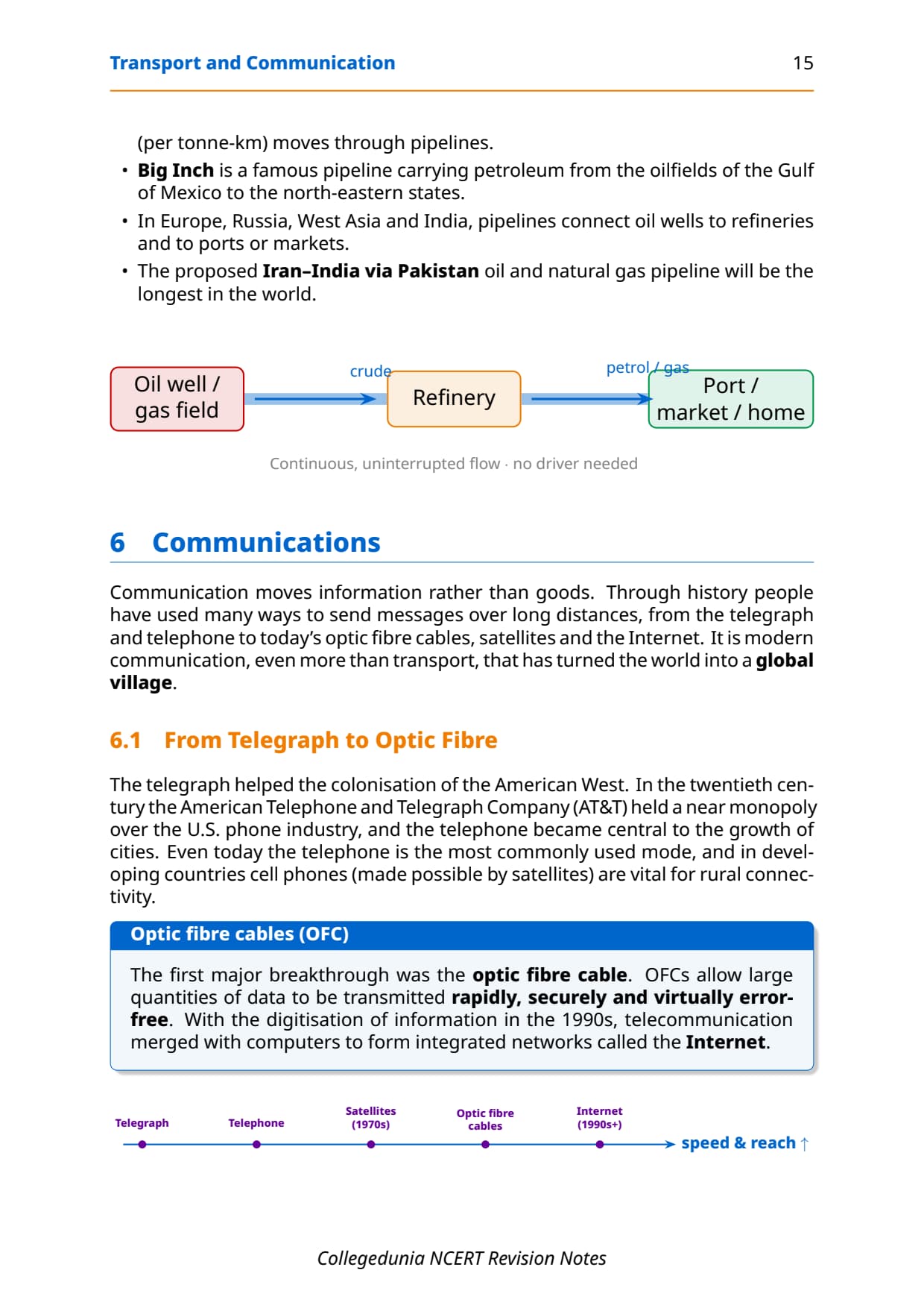
Pipelines carry liquids and gases (petroleum, natural gas, water) continuously and cheaply. The Big Inch pipeline in the USA moves petroleum from the Gulf of Mexico to the North-eastern states, and about 17% of US freight per tonne-km moves by pipeline. The proposed Iran-India pipeline via Pakistan would be the longest in the world.
| Mode | Best suited for | Key advantage | Key limitation |
|---|---|---|---|
| Roads | Short distances, door-to-door service | Flexible, cheapest for short hauls | Not all-weather on unmetalled roads; congestion in cities |
| Railways | Bulky goods and passengers over long distances | Carries large volumes; all-weather | High infrastructure cost; inflexible routes |
| Waterways | Bulky, heavy cargo between continents | Cheapest for long-distance bulk; no route construction | Slow; limited to navigable water bodies |
| Airways | Long-distance passengers; valuable or perishable goods | Fastest; reaches inaccessible areas | Most expensive; weather-dependent |
| Pipelines | Liquids and gases (petroleum, natural gas, water) | Continuous, uninterrupted flow; low per-unit cost | Only for specific materials; high initial investment |
Communication: Telegraph to Cyberspace
Communication moves information rather than goods or people. The chapter traces the arc from the telegraph through the telephone (AT&T held a US monopoly and the phone drove American urbanisation) to optic fibre cables, satellites and the Internet. This arc is a favourite 4-mark or 5-mark question.
The optic fibre cable (OFC) was the first major breakthrough, sending large data rapidly, securely and error-free; digitisation in the 1990s merged telecom with computers to form the Internet. Satellite communication (from the 1970s) makes cost and time invariant with distance: a message costs the same over 500 km or 5,000 km. India's milestones include Aryabhatt (1975), Bhaskar-I, Rohini and APPLE (1981).
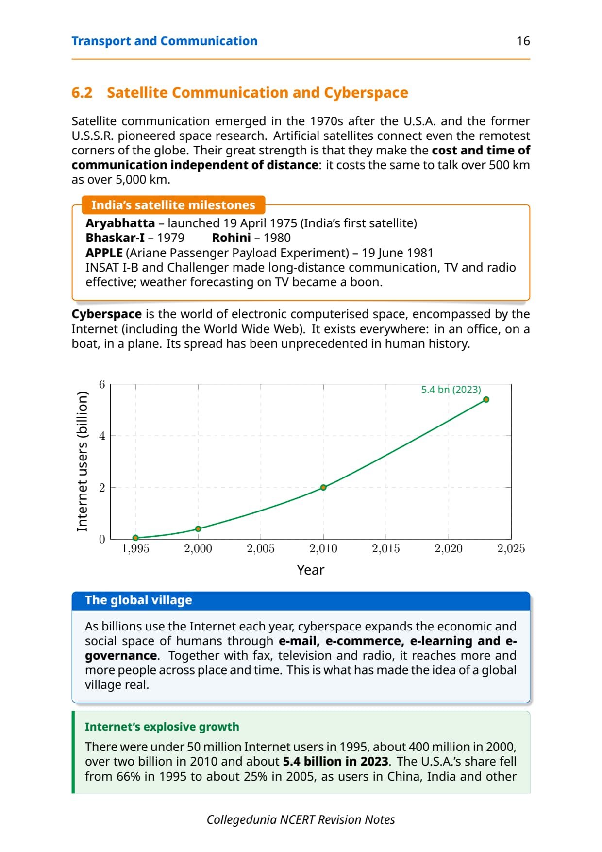
Cyberspace is the electronic space of the Internet, allowing access without physical movement. Its growth has been remarkable:
| Year | Internet users (approx.) | Key note |
|---|---|---|
| 1995 | Fewer than 50 million | USA accounted for 66% of users |
| 2000 | About 400 million | USA still dominant |
| 2010 | Over 2 billion | Shift to developing countries begins |
| 2023 | About 5.4 billion | Majority of users now in USA, UK, Germany, Japan, China and India |
Cyberspace expands human economic and social space through e-mail, e-commerce, e-learning and e-governance. The chapter concludes that modern communication, more than transport, has made the global village a reality.
Previous Year Question Trends from Transport and Communication Chapter 7
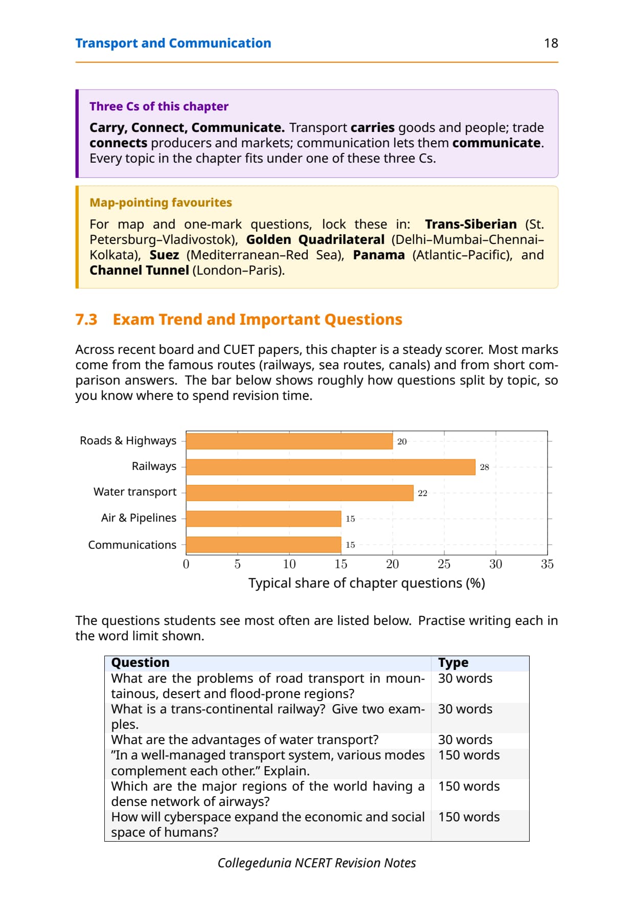
The chapter carries 6 to 8 marks across MCQs, short notes and analytical questions. The table below maps what CBSE has asked in recent years.
| Year | Question asked | Marks | Notes section to revise |
|---|---|---|---|
| 2025 | Explain how various modes of transport complement each other in a well-managed system + MCQ on Big Trunk Route | 5 + 1 | Mode Comparison Table + Sea Routes |
| 2024 | Name and describe the Trans-Siberian Railway + Suez Canal importance | 3 + 3 | Trans-Continental Railways table + Shipping Canals |
| 2023 | MCQ on Stuart Highway terminal cities + short note on cyberspace | 1 + 3 | Highways section + Communication section |
| 2022 | Major air transport nodal points + advantages of water transport | 3 + 3 | Air Transport section + Water Transport section |
| 2021 | What is the Big Inch pipeline + which mode is best for perishable goods and why | 2 + 3 | Pipelines section + Mode Comparison Table |
The chapter carries an effective weight of 6 to 8 marks per year across theory and objective questions.
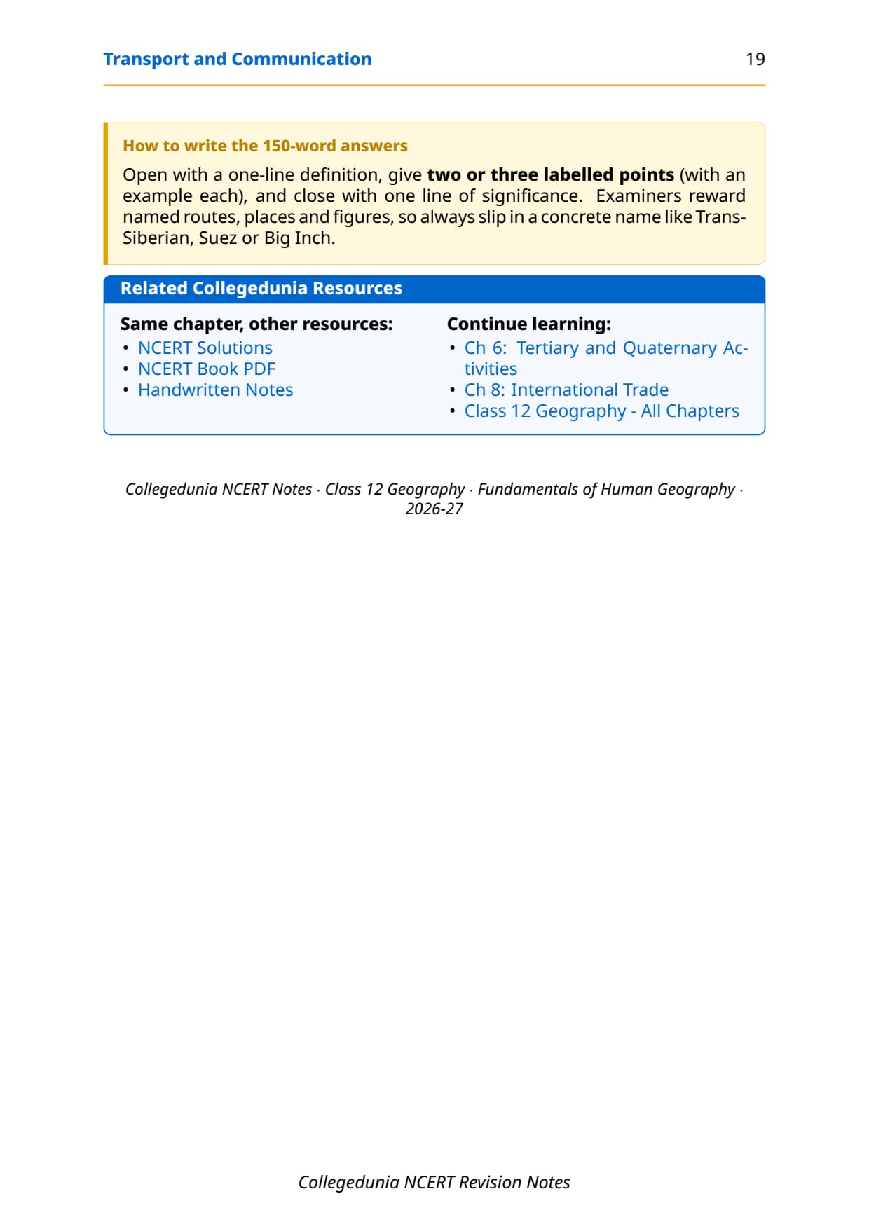
Other Resources for Class 12 Geography Chapter 7 Transport and Communication
Pair these revision notes with the matching resources for Class 12 Geography Chapter 7.
| Resource | What it covers | Open |
|---|---|---|
| Notes | Concept-first revision notes covering transport modes, sea routes, trans-continental railways, pipelines and the full communication arc. | You are here |
| NCERT Solutions | Step-by-step answers to all exercise questions on transport modes and communication with detailed explanations. | Class 12 Geography Chapter 7 NCERT Solutions |
| Handwritten Notes | Topper's handwritten revision pages for last-minute board exam practice on sea routes and railways. | Class 12 Geography Chapter 7 Handwritten Notes |
| NCERT Book PDF | Official NCERT Fundamentals of Human Geography Chapter 7 textbook in PDF form. | Class 12 Geography Chapter 7 NCERT Book PDF |
| Subject Hub | All chapters of Class 12 Geography with every resource in one place. | Class 12 Geography Subject Hub |
All Chapters Notes for Class 12 Geography (Fundamentals of Human Geography)
Related Links: Use the table below to navigate to the Notes for the other chapters of Class 12 Fundamentals of Human Geography. Every chapter ships with the same revision-friendly structure, key-definition table and FAQ block.
| Chapter | Topic | Notes link |
|---|---|---|
| Chapter 1 | Human Geography: Nature and Scope | Class 12 Geography Chapter 1 Notes |
| Chapter 2 | The World Population: Distribution, Density and Growth | Class 12 Geography Chapter 2 Notes |
| Chapter 3 | Human Development | Class 12 Geography Chapter 3 Notes |
| Chapter 4 | Primary Activities | Class 12 Geography Chapter 4 Notes |
| Chapter 5 | Secondary Activities | Class 12 Geography Chapter 5 Notes |
| Chapter 6 | Tertiary and Quaternary Activities | Class 12 Geography Chapter 6 Notes |
| Chapter 7 | Transport and Communication | You are here |
| Chapter 8 | International Trade | Class 12 Geography Chapter 8 Notes |
NCERT Notes Class 12 Geography Chapter 7 Transport and Communication FAQs
Ques. What are transport and communication class 12 notes meant to be used for?
Ans. These transport and communication class 12 notes are a concept-first revision file. They compress the entire NCERT Chapter 7 of Class 12 Fundamentals of Human Geography into a printable study guide, with definitions, mode-comparison tables, sea route lists and the communication arc from telegraph to cyberspace, all laid out for a single sitting. Students typically use these notes for a 30-minute first-pass revision and a 15-minute night-before pass; the worked exercise answers live in the matching NCERT Solutions PDF, not in this Notes file.
Ques. Which sea route is called the Big Trunk Route and why?
Ans. The Northern Atlantic Sea Route linking North-eastern USA to North-western Europe is called the Big Trunk Route. It is the busiest sea route in the world because roughly one-fourth of all global foreign trade moves on this route. Both coasts have highly advanced ports and harbour facilities, and the two regions (eastern North America and North-western Europe) are among the most industrially developed in the world, generating enormous two-way trade in manufactured goods, raw materials and agricultural products.
Ques. What is the Trans-Siberian Railway and why is it important for Class 12 Geography?
Ans. The Trans-Siberian Railway is the world's longest trans-continental rail route at 9,332 km, running from St. Petersburg in the west to Vladivostok on the Pacific Coast in the east, passing through Moscow, Ufa, Novosibirsk, Irkutsk, Chita and Khabarovsk. It is the most important route in Asia, fully double-tracked and electrified. It opened up Russia's Asian region to West European markets and remains the single most-tested trans-continental railway in both CBSE board papers and UPSC preliminary exams, so students must memorise the route, length and that it is double-tracked.
Ques. How are the Suez Canal and Panama Canal different?
Ans. The Suez Canal (1869, Egypt) is a sea-level canal without locks, about 160 km long, connecting the Mediterranean Sea to the Red Sea; it reduces the Europe-to-Asia distance compared to the Cape of Good Hope route and about 100 ships cross it daily. The Panama Canal (constructed by the USA) connects the Atlantic Ocean to the Pacific Ocean through the Panama Isthmus; it is about 72 km long with a six-lock system that raises ships 26 m. The Suez has greater global trade significance because it serves the busiest intercontinental routes, while the Panama Canal is more vital to Latin American economies and shortens the New York to San Francisco sea distance by 13,000 km.
Ques. What is cyberspace and how does the NCERT chapter define it?
Ans. The NCERT chapter defines cyberspace as the world of electronic computerised space encompassed by the Internet, such as the World Wide Web (www). It allows communication and information access without any physical movement of the sender or receiver. The chapter notes that cyberspace exists everywhere, from an office to a sailing boat to a flying plane. Internet users grew from fewer than 50 million in 1995 to about 5.4 billion in 2023, making cyberspace the fastest-spreading network in human history. The NCERT chapter concludes that modern communication, more than transportation, has made the concept of a global village a reality.
Ques. Why are pipelines considered a separate mode of transport in Class 12 Geography?
Ans. Pipelines are treated as a distinct mode of transport because they are the only mode that moves material continuously without requiring a vehicle or human carrier. They are used for liquids and gases such as petroleum, natural gas, water and even liquidised coal. The NCERT chapter gives the Big Inch pipeline in the USA (Gulf of Mexico oil wells to North-eastern states) as the key example, and notes that about 17% of all freight per tonne-km in the USA moves through pipelines. Pipelines are cost-effective for large, continuous volumes of a single material but cannot carry solid cargo, which is the main limitation that sets them apart from other modes.
Ques. Which continent has the least developed air transport network and why?
Ans. Africa, the Asiatic part of Russia and South America lack regular air services, according to the NCERT chapter. In the Southern Hemisphere between 10 and 35 degrees latitude, air services are limited because of sparser population, limited landmass area and lower levels of economic development. In contrast, the USA alone accounts for 60% of world airways, and the densest air networks are in Eastern USA, Western Europe and South-east Asia. For board and CUET answers, students should name all three under-served regions and give the three reasons: low population density, limited landmass and low economic development.
Ques. How do these transport and communication notes differ from the NCERT Solutions PDF?
Ans. These transport and communication class 12 notes carry definitions, mode-comparison tables, sea route lists and the communication arc for concept revision without worked exercise answers. The NCERT Solutions PDF takes each exercise question in the textbook and works through it step by step with the full reasoning, facts and a conclusion, plus an expert solution alternative. The Notes file is for memorising key facts and building a mental map of the chapter; the Solutions PDF is for practicing how to write a board-exam quality answer. Students get the best result by using the Notes first and then switching to the Solutions PDF for exercise practice.
Ques. Is the Class 12 Geography syllabus for these notes changing in 2026-27?
Ans. No major reductions in 2026-27. The Fundamentals of Human Geography textbook chapter structure is unchanged for the current cycle, and the CBSE marking scheme continues to reward factual accuracy plus organised presentation in long-answer questions. These transport and communication class 12 notes for the 2026-27 cycle are aligned to the unchanged textbook and the latest CBSE sample paper released for the 2026 boards. CUET Geography and UPSC Prelims also continue to draw questions from this chapter without changes to the scope.
Ques. What is the Rhine Waterway and why is it important in Class 12 Geography?
Ans. The Rhine Waterway is the world's most heavily used inland waterway. It flows through Germany and the Netherlands and is navigable for 700 km from Rotterdam at its mouth to Basel in Switzerland. Each year more than 20,000 ocean-going ships and 2,00,000 inland vessels exchange cargoes on the Rhine. The Ruhr river joins the Rhine from the east and the basin has become a prosperous manufacturing region. The Rhine connects the industrial areas of Switzerland, Germany, France, Belgium and the Netherlands with the North Atlantic Sea Route, making it a critical artery for European trade. CBSE and UPSC ask factual short-note questions on the Rhine regularly.



Comments