




The Class 12 Geography Chapter 6 Planning and Sustainable Development in Indian Context textbook PDF is the official NCERT source for every board question on target area planning, the Bharmaur tribal development project, the Indira Gandhi Canal Command Area, and the Brundtland definition of sustainable development. It carries about 5 to 6 marks in the CBSE board exam and is a high-priority chapter for UPSC and CUET preparation.
- Official NCERT India: People and Economy Class 12 Chapter 6 PDF covering regional planning, target area programmes, ITDP in Bharmaur, the Indira Gandhi Canal project, and the concept of sustainable development.
- 5-6 marks CBSE board-paper weightage for Chapter 6; the official textbook is the only source CBSE references when it sets definition, case-study, and short-answer questions on planning and sustainable development.
- Pair with the matching NCERT Solutions, Notes and Handwritten Notes for full chapter coverage.
Student Feedback
In a 2026 Collegedunia survey of Class 12 Geography students, 84% said the NCERT textbook PDF was their primary source for Chapter 6. Those who paired it with the matched Notes and Solutions scored higher on planning, ITDP and sustainable development questions.
What This Chapter Covers in the NCERT Class 12 Book
The official NCERT textbook is the only document CBSE references for board questions on regional planning, target area programmes and the Brundtland definition, so students should read this PDF first for the 2026-27 board paper. The chapter covers two planning approaches, sectoral (across sectors like agriculture and power) and regional (reducing spatial imbalances), then applies them through Target Area Planning (Hill Area, Drought Prone and the ITDP in Bharmaur) and the Indira Gandhi Canal Command Area case study in Rajasthan.
Source: HUMAN-AT-EASE on YouTube
Topics in the Chapter (Section-Wise Map of the NCERT PDF)
The table below maps each NCERT section to the key concept students need for exams.
| Section | NCERT Sub-topic | Dominant Exam Concept |
|---|---|---|
| 6.1 | Planning in India: Sectoral and Regional | Difference between sectoral and regional planning; NITI Aayog replacing Planning Commission |
| 6.2 | Target Area Planning | Command Area Development, Drought Prone Area Programme, Desert Development Programme, Hill Area Development Programme |
| 6.3 | Hill Area Development Programme | Fifth Five Year Plan; 15 districts; horticulture, forestry, animal husbandry focus |
| 6.4 | Drought Prone Area Programme | Fourth Five Year Plan; ecological balance; watershed development approach |
| 6.5 | Case Study - ITDP Bharmaur | Gaddi tribe; Chamba district; social and economic benefits of tribal sub-plan |
| 6.6 | Sustainable Development | Brundtland Report 1987; "Our Common Future"; ecological, social and economic sustainability |
| 6.7 | Case Study - Indira Gandhi Canal | Stage I and Stage II; twin problems of waterlogging and soil salinity; seven sustainability measures |
The Bharmaur case study and the Brundtland definition account for the largest share of board questions. Questions on the Indira Gandhi Canal and its environmental problems are also common in recent CBSE papers and UPSC prelims.
Target Area Programmes in India
The chapter lists the major target area programmes launched to address regional imbalances. The exam often asks students to name a programme and link it to the Five Year Plan under which it started, so learn the plan-wise launch of each one.
| Programme | Plan Launched | Focus Area |
|---|---|---|
| Hill Area Development Programme | Fifth Five Year Plan | Horticulture, animal husbandry, forestry, small-scale industry in 15 hill districts |
| Drought Prone Area Programme | Fourth Five Year Plan | Employment generation, ecological restoration, watershed management in drought-prone areas |
| Desert Development Programme | Planning Commission initiative | Arresting desertification, afforestation, and water conservation in arid zones |
| Command Area Development Programme | Target area approach | Efficient utilisation of irrigation water; warabandi system; land development |
| Integrated Tribal Development Project (ITDP) | Fifth Five Year Plan (1974) | Tribal sub-plan in Bharmaur, Himachal Pradesh; infrastructure, literacy, agriculture |
Growing regional imbalances after about one-and-a-half decades of national planning led to these target area and target group approaches. On 1 January 2015 the Planning Commission was replaced by NITI Aayog, a more advisory, cooperative-federalism body.
Key Concepts From the Class 12 Geography Textbook
CBSE examiners reward exact NCERT phrasing, so reproduce these ideas in textbook language.
Sectoral vs Regional Planning
Sectoral planning means programmes for each sector of the economy (agriculture, power, transport) with no specific geographic focus. Regional planning targets spatial imbalances so that less-developed areas catch up. Their distinction is a standard one-mark MCQ.
The Bharmaur ITDP Case Study
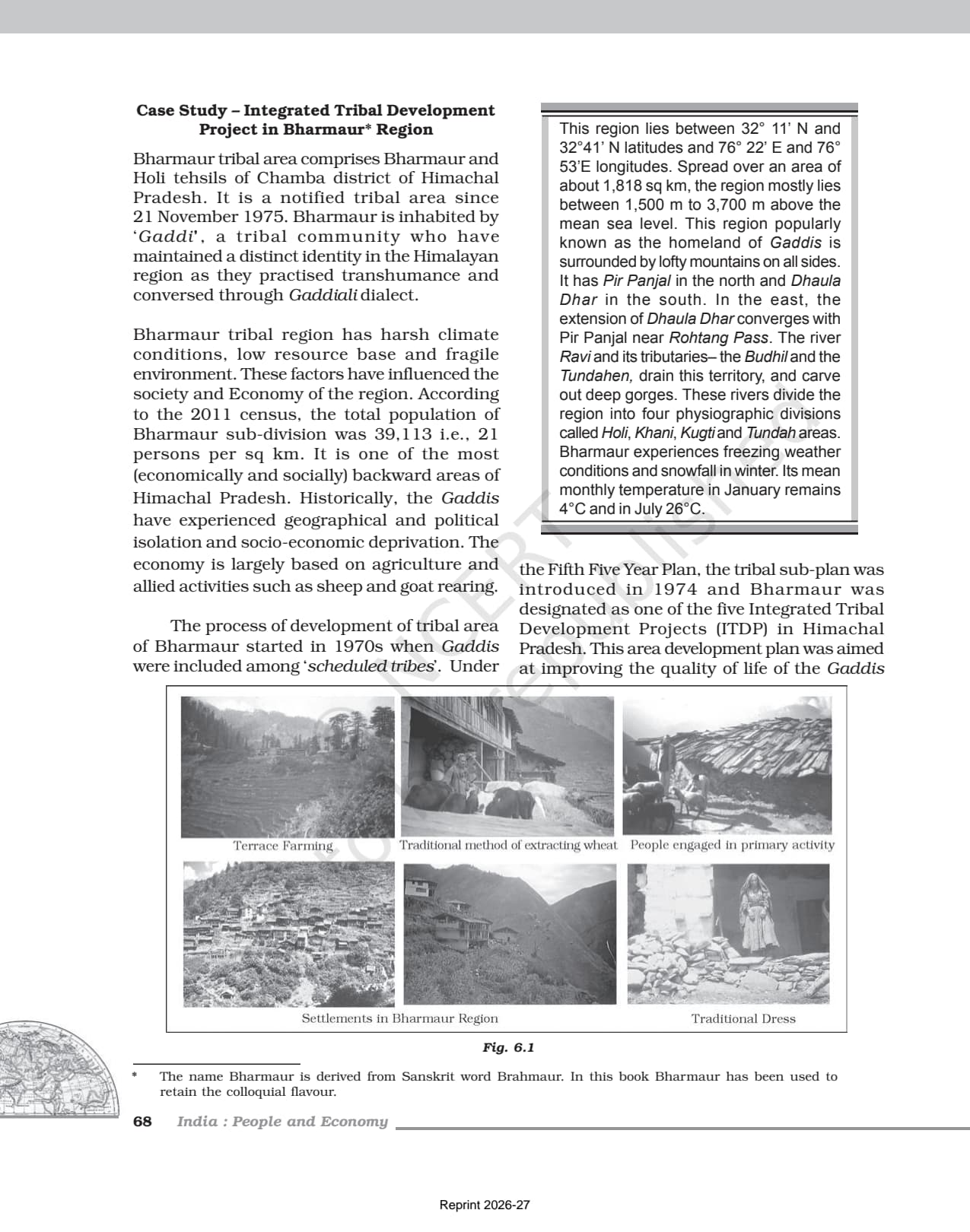
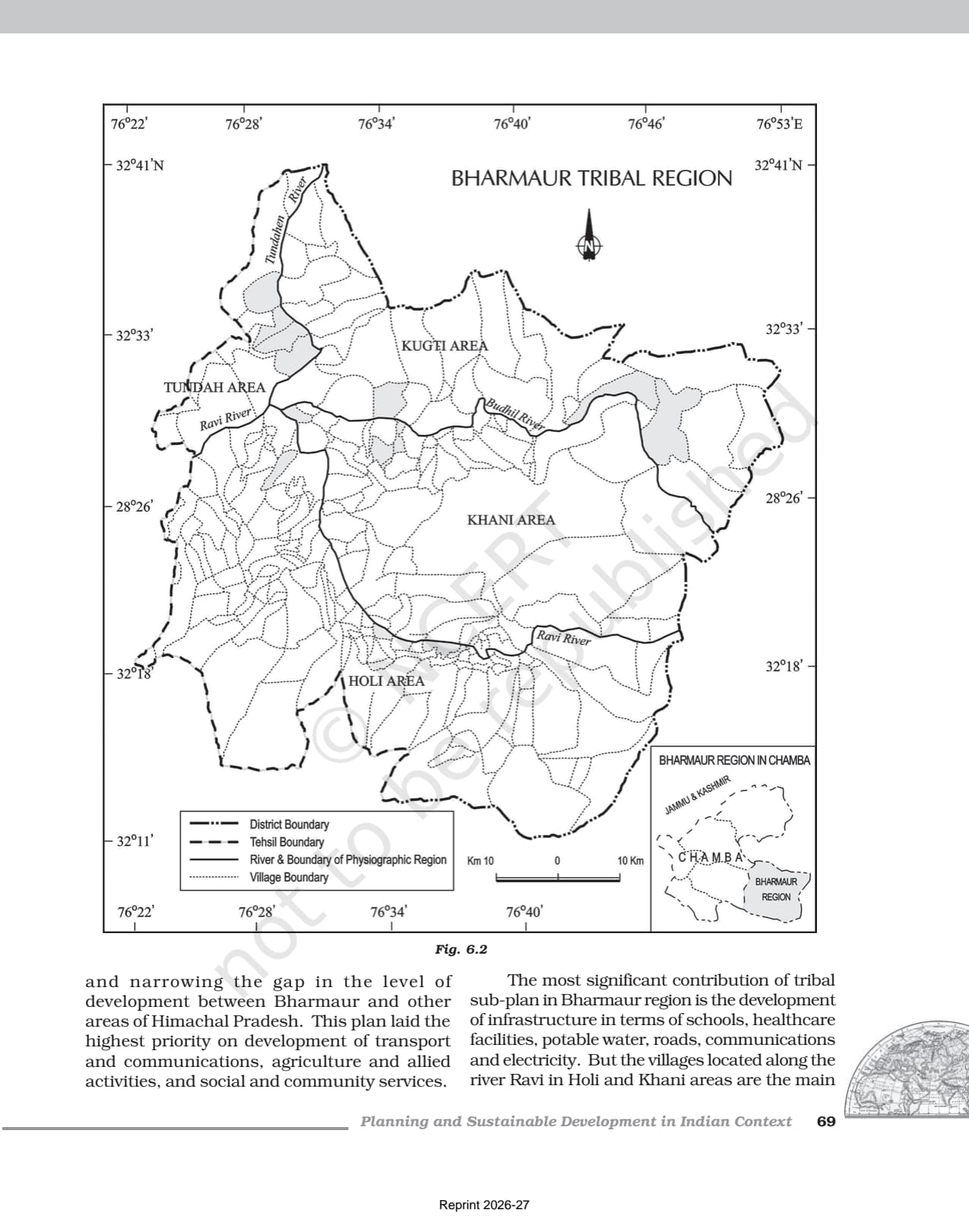
Bharmaur (Bharmaur and Holi tehsils, Chamba district, Himachal Pradesh) is home to the Gaddi tribe, who practise transhumance. The tribal sub-plan started in 1974 under the Fifth Five Year Plan, prioritising transport, agriculture and social services. Female literacy rose from 1.88% in 1971 to 65% in 2011, the chapter's most-cited outcome and a frequent short-answer question.
The Brundtland Definition of Sustainable Development
The Brundtland Report (1987), "Our Common Future" by the WCED under Gro Harlem Brundtland, defines sustainable development as "development that meets the needs of the present without compromising the ability of future generations to meet their own needs." Reproduce this word-for-word to earn full marks.
The Indira Gandhi Canal Command Area
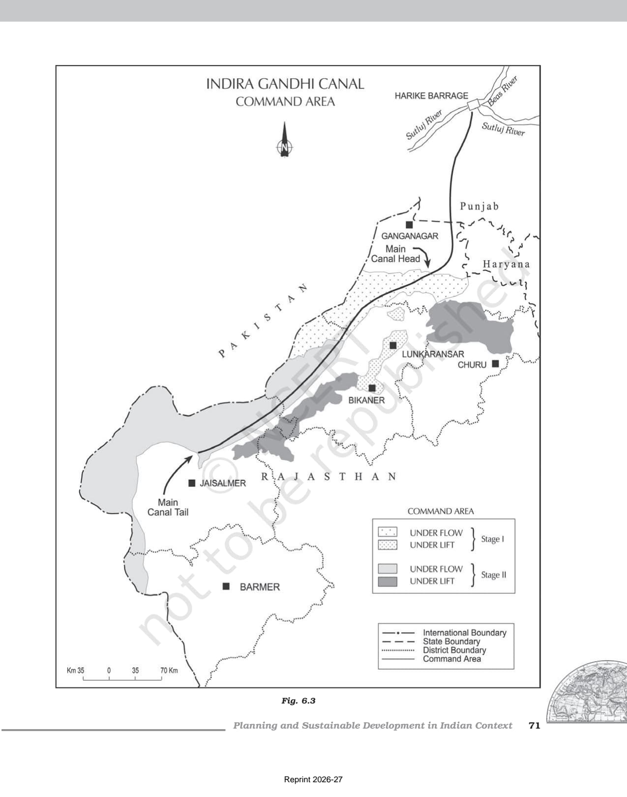
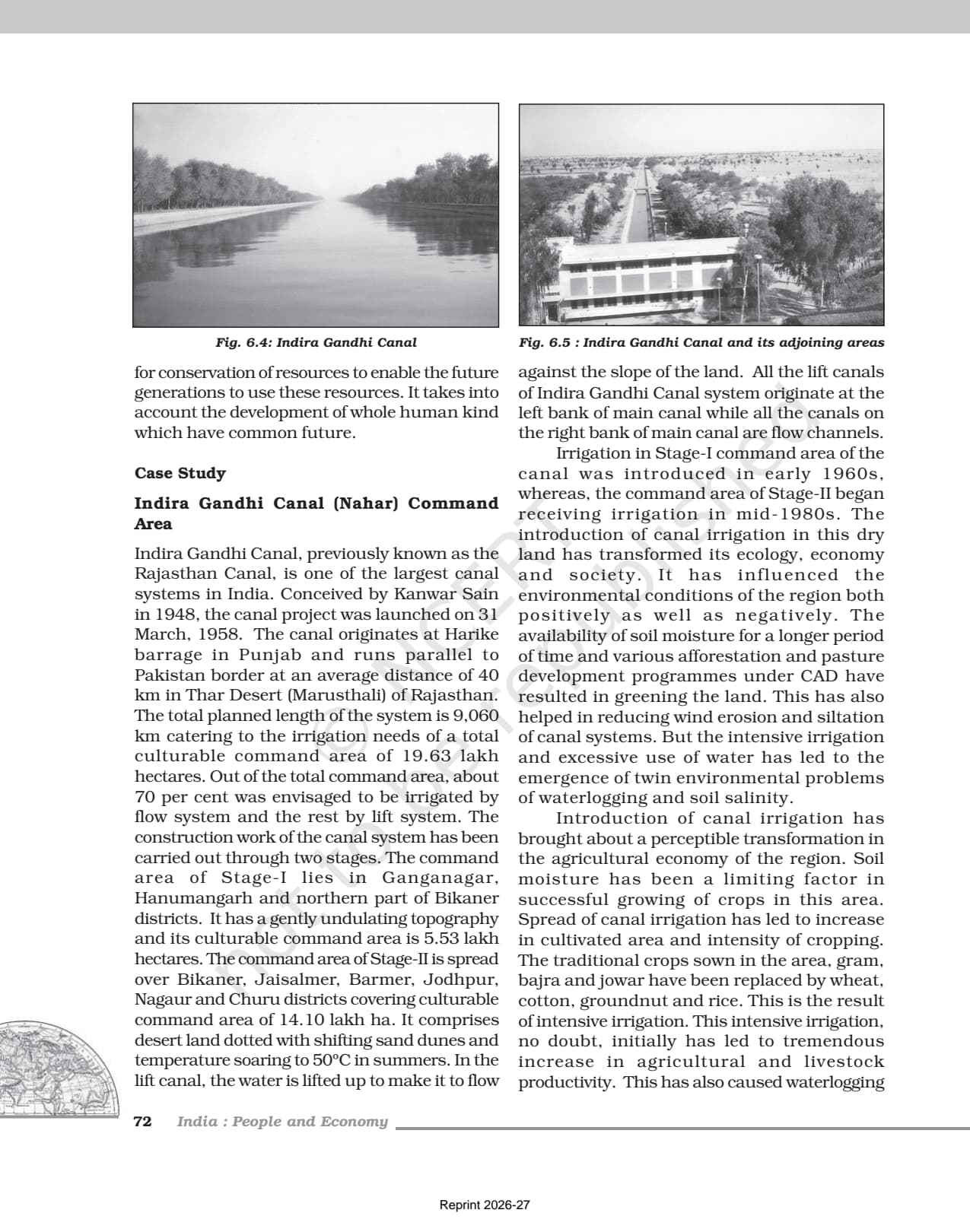
The Indira Gandhi Canal (formerly Rajasthan Canal) starts at Harike Barrage in Punjab and runs through the Thar Desert. Stage I covers Ganganagar, Hanumangarh and north Bikaner (5.53 lakh hectares); Stage II covers Bikaner, Jaisalmer, Barmer, Jodhpur, Nagaur and Churu (14.10 lakh hectares). Irrigation greened the desert but created the twin problems of waterlogging and soil salinity, so know both positive and negative impacts.
Previous Year Question Trends From This NCERT Chapter
Expect 2026-27 questions on the Brundtland definition, the Bharmaur case study, target area programmes and the Indira Gandhi Canal. The chapter regularly contributes 5 to 8 marks, with case-study short and long answers being most common. UPSC Prelims also draws from it.
| Year | Question Type | Most Common Topic | Marks |
|---|---|---|---|
| 2025 | Short answer + MCQ | Social benefits of ITDP in Bharmaur | 5 |
| 2024 | Short answer + MCQ | Sustainable development definition and dimensions | 6 |
| 2023 | Long answer + MCQ | Indira Gandhi Canal: positive impacts and environmental problems | 8 |
| 2022 | Short answer | Drought Prone Area Programme objectives | 4 |
| 2020 | Short answer + MCQ | Target area approach; Hill Area Development Programme | 5 |
The most consistent question is a short answer on the social benefits of ITDP in Bharmaur or on the Brundtland definition. Long answers on the Indira Gandhi Canal (both positive and negative impacts) appear in roughly every second year.
Connecting This Chapter to the Rest of Class 12 Geography
Chapter 6 links to neighbouring chapters in the India: People and Economy book, extending the conservation theme of Chapter 5 into sustainable development and feeding into the environmental issues of Chapter 9.
| Connected Chapter | Concept Inherited From Chapter 6 |
|---|---|
| Chapter 3: Land Resources and Agriculture | Land development and irrigation as tools of agricultural planning |
| Chapter 4: Water Resources | Watershed development approach; water management policy |
| Chapter 5: Mineral and Energy Resources | Resource conservation logic extended to sustainable development |
| Chapter 7: Transport and Communication | Role of road and canal infrastructure in area development programmes |
| Chapter 9: Geographical Perspective on Selected Issues | Environmental degradation, land degradation, waterlogging as development side effects |
Quick Glossary From the NCERT Class 12 Geography Chapter
Be able to define each term in one line, in textbook phrasing.
- Sectoral planning: Formulation and implementation of programmes aimed at developing various sectors of the economy such as agriculture, power, and transport.
- Regional planning: Planning with a spatial perspective, aimed at reducing regional imbalance in development across different areas of a country.
- Target area approach: Planning that focuses on specific backward areas (or target groups) to accelerate their development through special programmes.
- Transhumance: Seasonal movement of people with their livestock between fixed summer and winter pastures; practised by the Gaddi tribe of Bharmaur.
- Sustainable development: Development that meets the needs of the present without compromising the ability of future generations to meet their own needs (Brundtland, 1987).
- Waterlogging: Saturation of soil with water due to over-irrigation, reducing soil productivity; a major problem in Indira Gandhi Canal Stage I area.
- Warabandi: A system of equal distribution of canal water in the command area of an outlet; used in Indira Gandhi Canal Command Area.
- NITI Aayog: National Institution for Transforming India; replaced the Planning Commission on 1 January 2015; focuses on cooperative federalism and strategic advice.
Indira Gandhi Canal and Sustainable Development
This case study shows how planned development can both improve and damage the environment. The textbook questions the ecological sustainability of the project, a common prompt for 5-mark long answers. Know the seven sustainability measures from memory.
Positive and Negative Impacts of the Canal
- Positive: greening of desert land, afforestation and pasture, reduced wind erosion, and higher crop yields.
- Negative: waterlogging and soil salinity from excessive irrigation, and long-term environmental degradation.
Seven Measures for Sustainable Development in the Command Area
- Strict water management: protective irrigation in Stage I; pasture development in Stage II.
- Cropping control: avoid water-intensive crops; encourage citrus plantation crops.
- CAD programmes: lining of water courses, land levelling and the warabandi system.
- Reclamation: reclaim waterlogged and saline areas.
- Eco-development: afforestation, shelterbelts and pasture, especially in Stage II.
- Social sustainability: financial and institutional support to poor land allottees.
- Economic diversification: link villages, agro-service centres and market centres beyond farming.
Also Explore Other Resources for Class 12 Geography
| Resource | Link |
|---|---|
| NCERT Solutions | Class 12 Geography Chapter 6 NCERT Solutions |
| Revision Notes | Class 12 Geography Chapter 6 Notes |
| Handwritten Notes | Class 12 Geography Chapter 6 Handwritten Notes |
| Subject Hub | Class 12 Geography All Chapters |
All Chapters: Class 12 Geography India People and Economy NCERT Book PDF
| Chapter | NCERT Book PDF |
|---|---|
| Chapter 1 | Population Distribution, Density, Growth and Composition |
| Chapter 2 | Human Settlements NCERT Book PDF |
| Chapter 3 | Land Resources and Agriculture NCERT Book PDF |
| Chapter 4 | Water Resources NCERT Book PDF |
| Chapter 5 | Mineral and Energy Resources NCERT Book PDF |
| Chapter 6 | Planning and Sustainable Development NCERT Book PDF (You are here) |
| Chapter 7 | Transport and Communication NCERT Book PDF |
| Chapter 8 | International Trade NCERT Book PDF |
| Chapter 9 | Geographical Perspective on Selected Issues NCERT Book PDF |
Frequently Asked Questions on Class 12 Geography Chapter 6 NCERT Book PDF
Ques. Where can students download the official NCERT Class 12 Geography Chapter 6 PDF?
Ans. Students can download the official planning and sustainable development class 12 NCERT book PDF directly from the download card at the top of this page. The PDF is the Chapter 6 file from the NCERT India: People and Economy textbook, aligned to the 2026-27 CBSE syllabus.
Ques. What is the Brundtland definition of sustainable development given in the NCERT Class 12 Geography chapter?
Ans. The NCERT chapter quotes the Brundtland Report (1987), titled "Our Common Future", which defines sustainable development as "development that meets the needs of the present without compromising the ability of future generations to meet their own needs." Students should reproduce this definition word-for-word in the board paper to earn full marks.
Ques. What is the difference between sectoral planning and regional planning as explained in the NCERT chapter?
Ans. Sectoral planning means formulating programmes aimed at the development of various sectors of the economy (agriculture, power, manufacturing, transport, social infrastructure) without a specific spatial focus. Regional planning is area-specific: it focuses on the uneven pattern of development across space and aims to reduce regional imbalances. Both concepts are introduced at the start of Chapter 6 in the NCERT India: People and Economy textbook.
Ques. What are the social benefits of the ITDP in Bharmaur tribal region according to the NCERT chapter?
Ans. According to the NCERT chapter, the social benefits of the Integrated Tribal Development Project in Bharmaur include: a tremendous increase in literacy rate (female literacy rose from 1.88% in 1971 to 65% in 2011); improvement in sex ratio; decline in child marriage; and reduction in gender inequality in literacy. Infrastructure benefits include schools, healthcare facilities, potable water, roads, and electricity in the region.
Ques. What are the twin environmental problems created by intensive irrigation in the Indira Gandhi Canal Command Area?
Ans. The NCERT chapter identifies waterlogging and soil salinity as the twin environmental problems caused by intensive and excessive use of irrigation water in the Indira Gandhi Canal Command Area. These problems degrade soil productivity and hamper the long-term sustainability of agriculture in the region. They are a direct result of over-irrigation without adequate drainage infrastructure.
Ques. What are the target area programmes mentioned in the NCERT Class 12 Geography Chapter 6?
Ans. The NCERT chapter mentions several target area programmes: the Command Area Development Programme, the Drought Prone Area Development Programme (launched in the Fourth Five Year Plan), the Desert Development Programme, and the Hill Area Development Programme (launched in the Fifth Five Year Plan, covering 15 hill districts). The Integrated Tribal Development Project (ITDP) in Bharmaur is also presented as an example of a target area programme under the Fifth Five Year Plan.
Ques. What is the significance of NITI Aayog replacing the Planning Commission in 2015?
Ans. On 1 January 2015, the Planning Commission was replaced by NITI Aayog (National Institution for Transforming India). NITI Aayog was set up with the objective of involving states in economic policy-making and providing strategic and technical advice to central and state governments. Unlike the Planning Commission, which had centralised planning authority, NITI Aayog operates as a policy think tank promoting cooperative federalism.
Ques. What is the Hill Area Development Programme mentioned in the NCERT Class 12 Geography chapter?
Ans. The Hill Area Development Programme was initiated during the Fifth Five Year Plan, covering 15 districts including all hilly districts of Uttar Pradesh (present Uttarakhand), Mikir Hill and North Cachar hills of Assam, Darjeeling in West Bengal, and Nilgiri district of Tamil Nadu. The programme aimed at developing horticulture, plantation, agriculture, animal husbandry, poultry, forestry, and small-scale and village industry using the indigenous resources of hill areas.
Ques. What are the seven measures to promote sustainable development in the Indira Gandhi Canal Command Area?
Ans. The NCERT chapter lists seven measures: (i) strict implementation of water management policy; (ii) avoiding water-intensive crops and encouraging plantation crops like citrus fruits; (iii) implementing CAD programmes including lining of water courses and warabandi system; (iv) reclaiming areas affected by waterlogging and soil salinity; (v) eco-development through afforestation, shelterbelt plantation, and pasture development; (vi) providing financial and institutional support to economically weak land allottees; and (vii) diversifying the economic base beyond agriculture through functional linkages between villages, agro-service centres, and market centres.
Ques. Is the Class 12 Geography syllabus changing for 2026-27?
Ans. No major structural changes have been announced for 2026-27. The India: People and Economy textbook chapter structure remains unchanged, and the official NCERT PDF on this page is aligned to the 2026-27 CBSE syllabus. CBSE marking schemes continue to reward textbook phrasing in theory answers and accurate case study details in short-answer and long-answer responses.
Ques. What is the best order to use the NCERT PDF, Notes, and Solutions for Class 12 Geography Chapter 6?
Ans. Read the NCERT PDF first (cold read, noting unfamiliar programme names, statistics, and place names). Then open the matching Class 12 Geography Chapter 6 Notes alongside the PDF to build your timeline of programmes and case study facts. Attempt all end-of-chapter questions and verify against the NCERT Solutions. Use the Handwritten Notes for last-mile revision the day before the board exam.



Comments