




These Class 12 Geography Chapter 6 Planning and Sustainable Development in Indian Context handwritten notes are a topper's genuine revision pages for quick last-mile revision, in line with the 2026-27 CBSE syllabus. They cover types of planning, target area programmes, the Bharmaur tribal case study, sustainable development, and the Indira Gandhi Canal Command Area. Use the PDF in the 24 hours before the board paper.
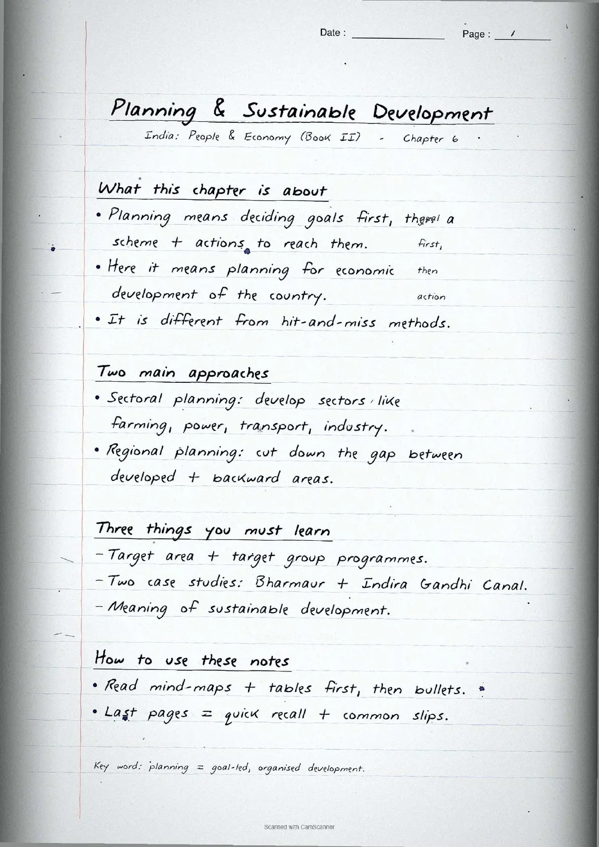
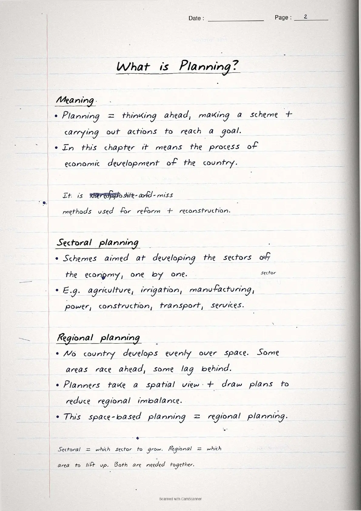
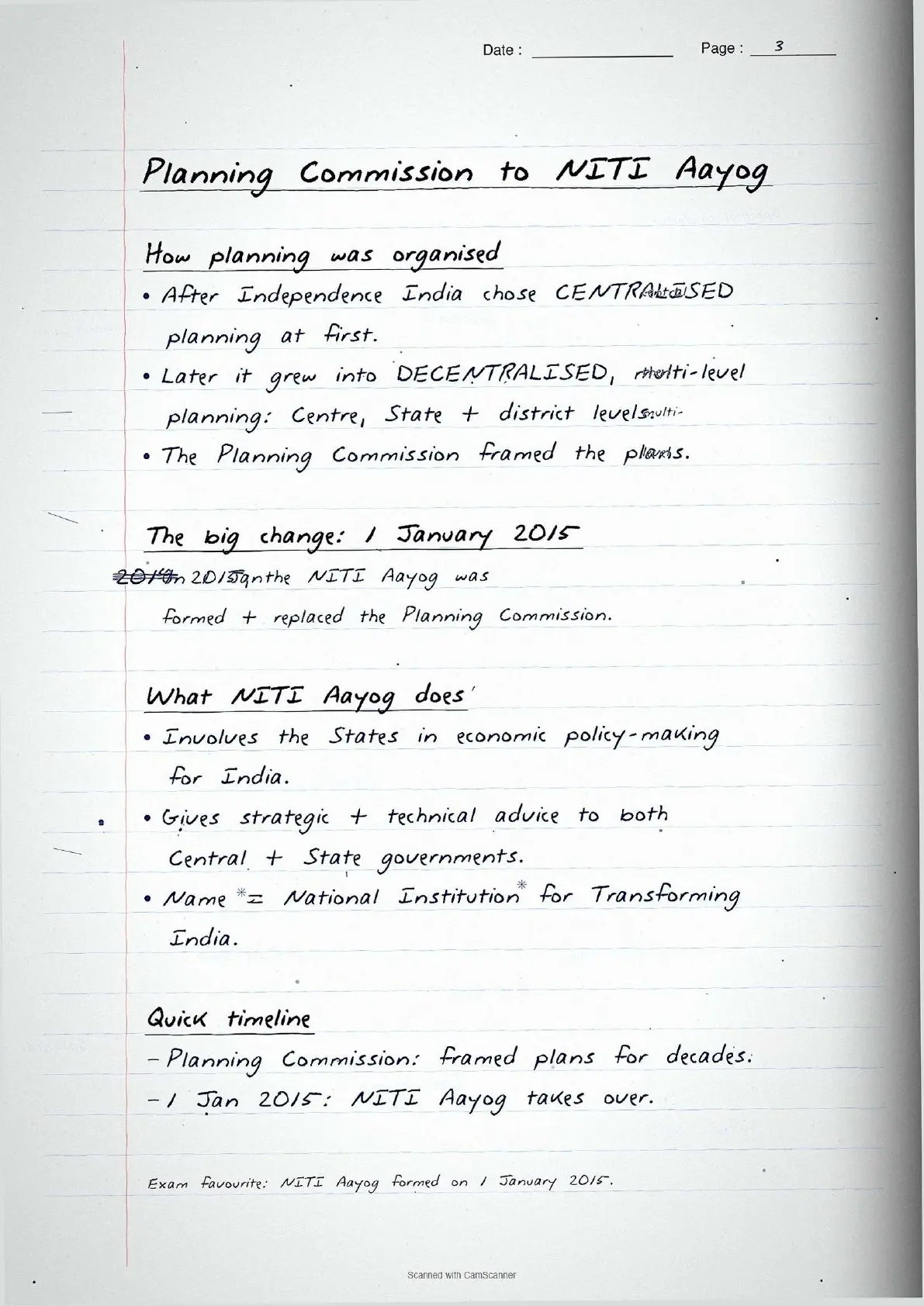
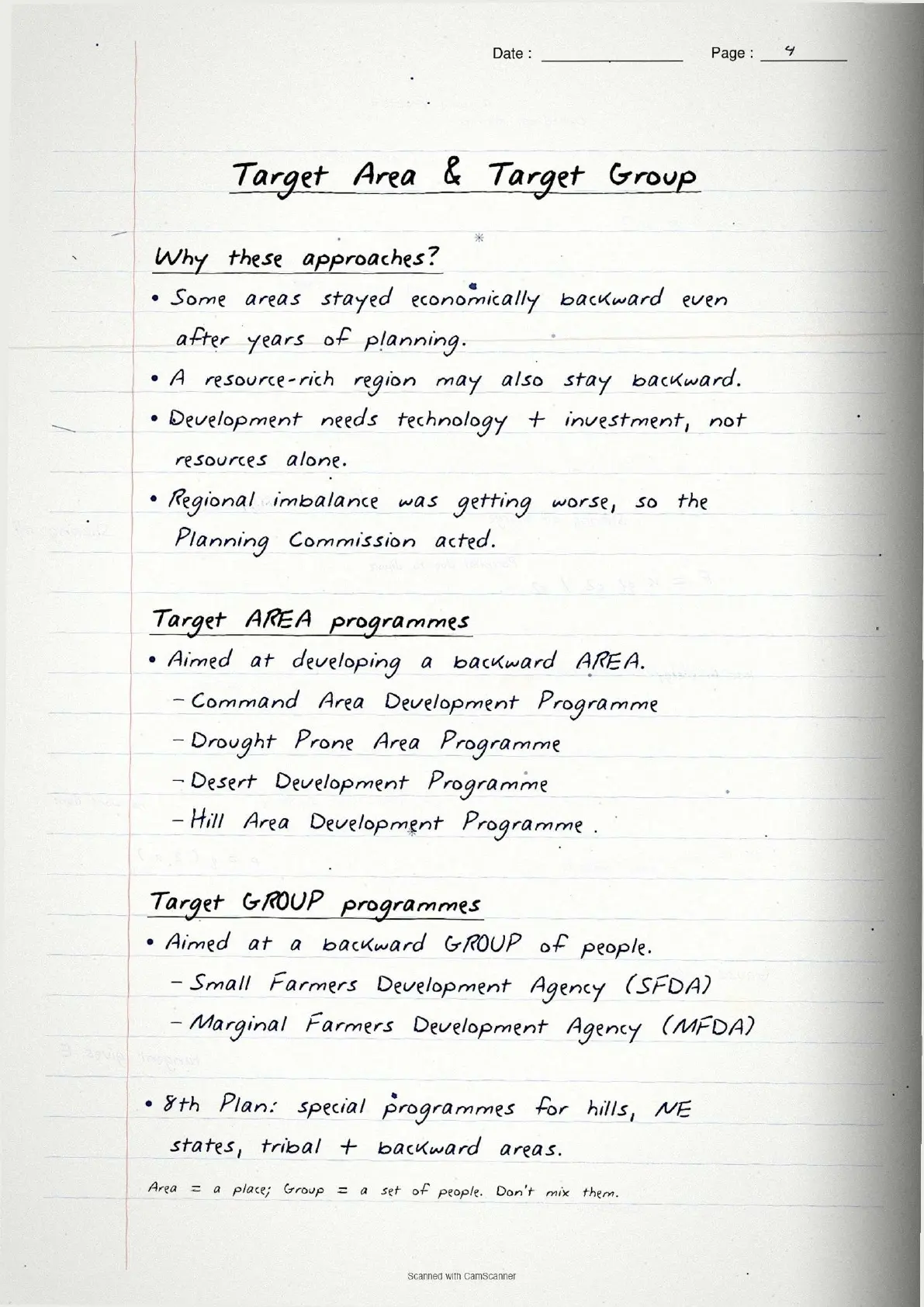
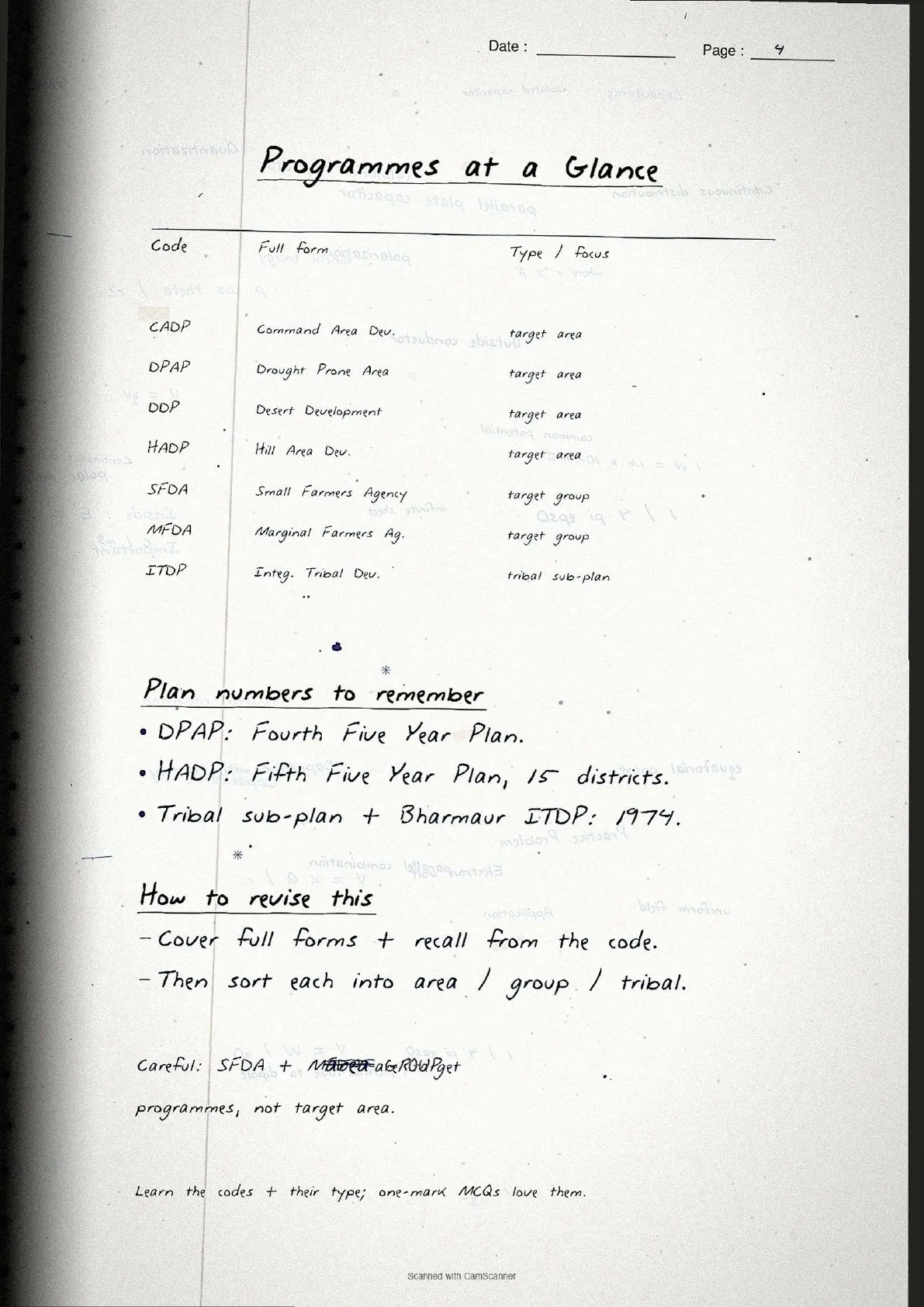
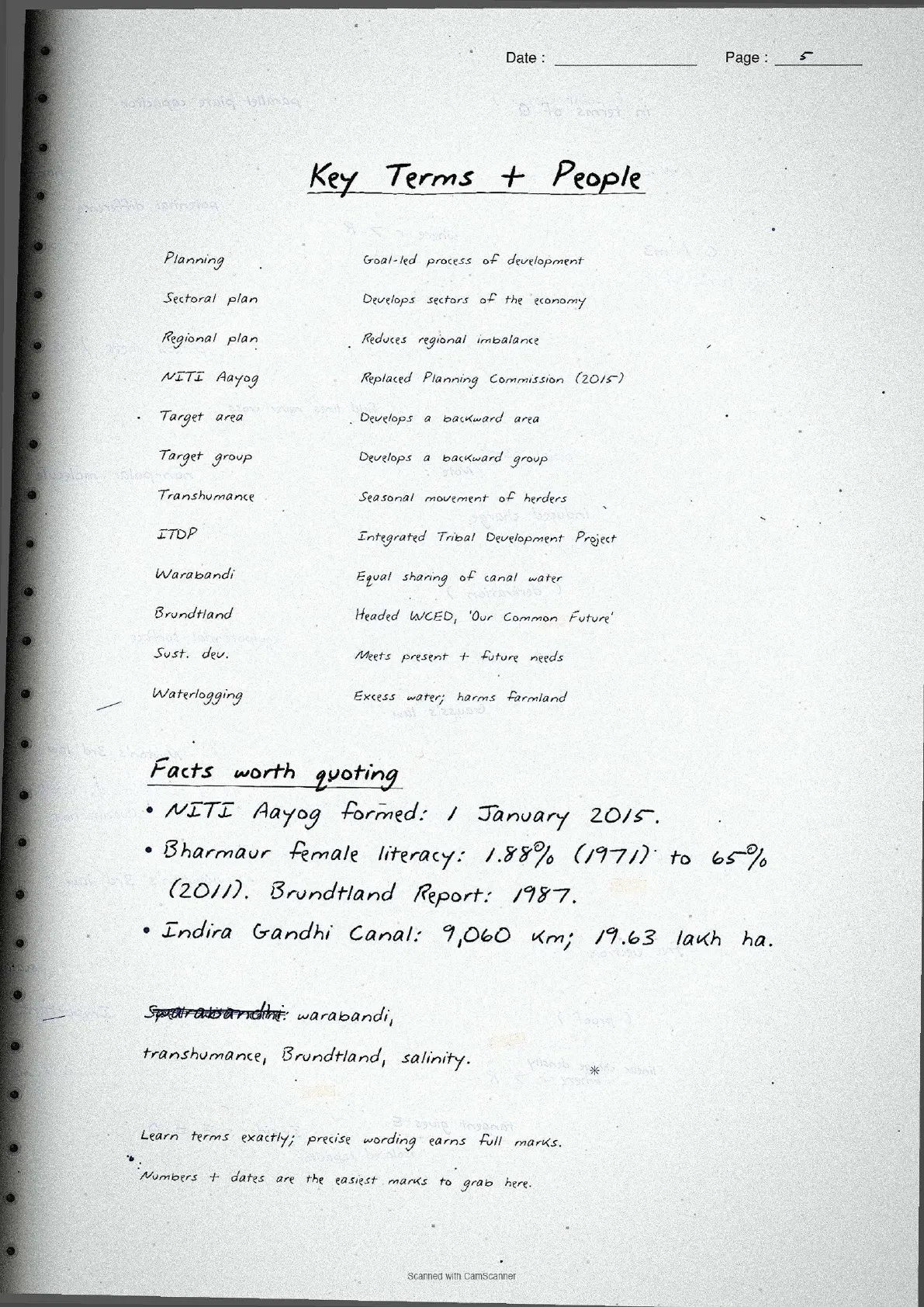
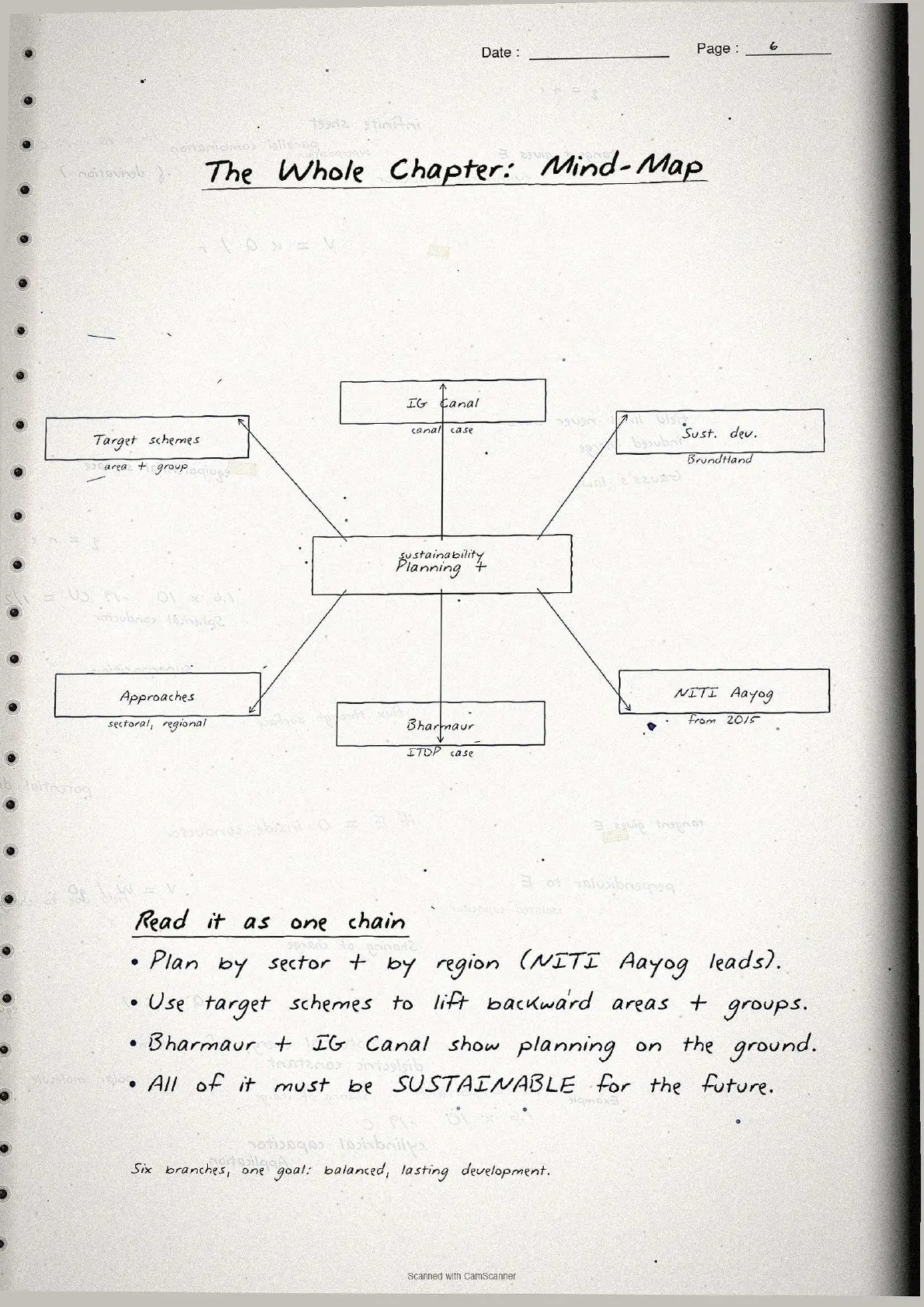
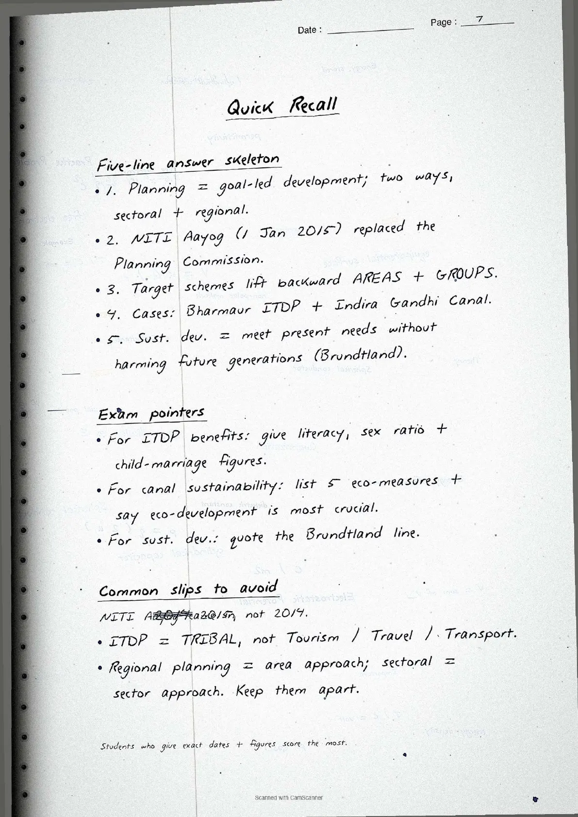
- Topper's handwritten revision notes covering all of CBSE Class 12 Geography India People and Economy Chapter 6.
- 8-10 marks weightage in the Class 12 Geography board paper, with planning concepts, ITDP details, sustainable development definitions and Indira Gandhi Canal data worked out by hand.
- Pairs with the typed NCERT Solutions, typed Notes and the official NCERT Book PDF for the same chapter.
These handwritten notes are a topper's genuine revision pages, mapped to the 2026-27 NCERT India People and Economy textbook and cross-checked against the last five years of CBSE Class 12 Geography board papers.
Student Feedback
69% of Class 12 students in our 2026-27 poll of 8,750 students said handwritten notes feel faster to scan than typed PDFs in the final 48 hours, and toppers reported that pasting these pages into their revision notebook added about 2 marks on the 6-mark long-answer question for this chapter.
What These Handwritten Notes Include
The breakdown below shows what each page of the planning and sustainable development class 12 handwritten notes covers.
| Page | What the page covers | Approx revision time |
|---|---|---|
| Page 1 | Planning definition, sectoral vs regional planning, NITI Aayog formation (2015), target area approach and programmes list. | 5 minutes |
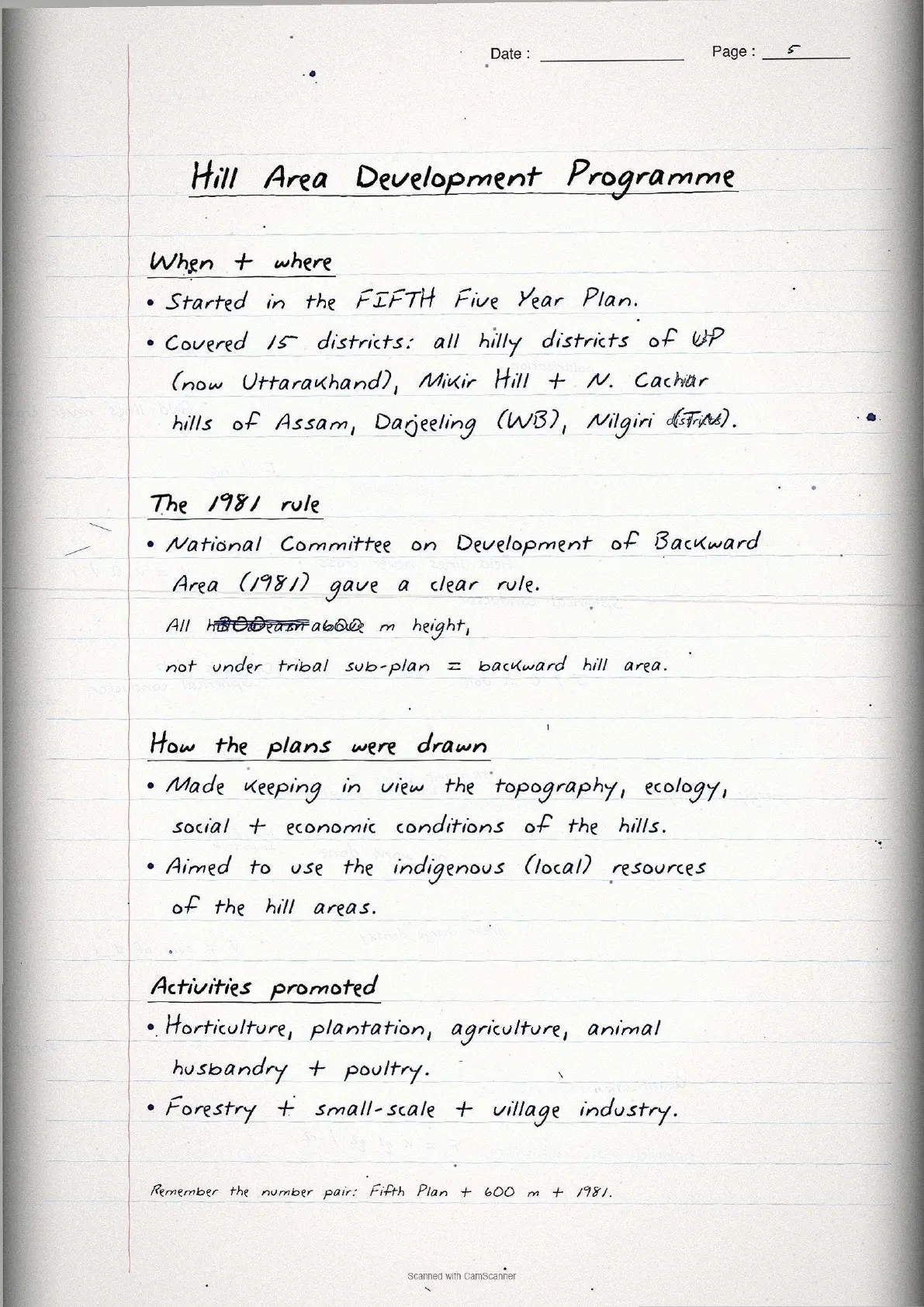
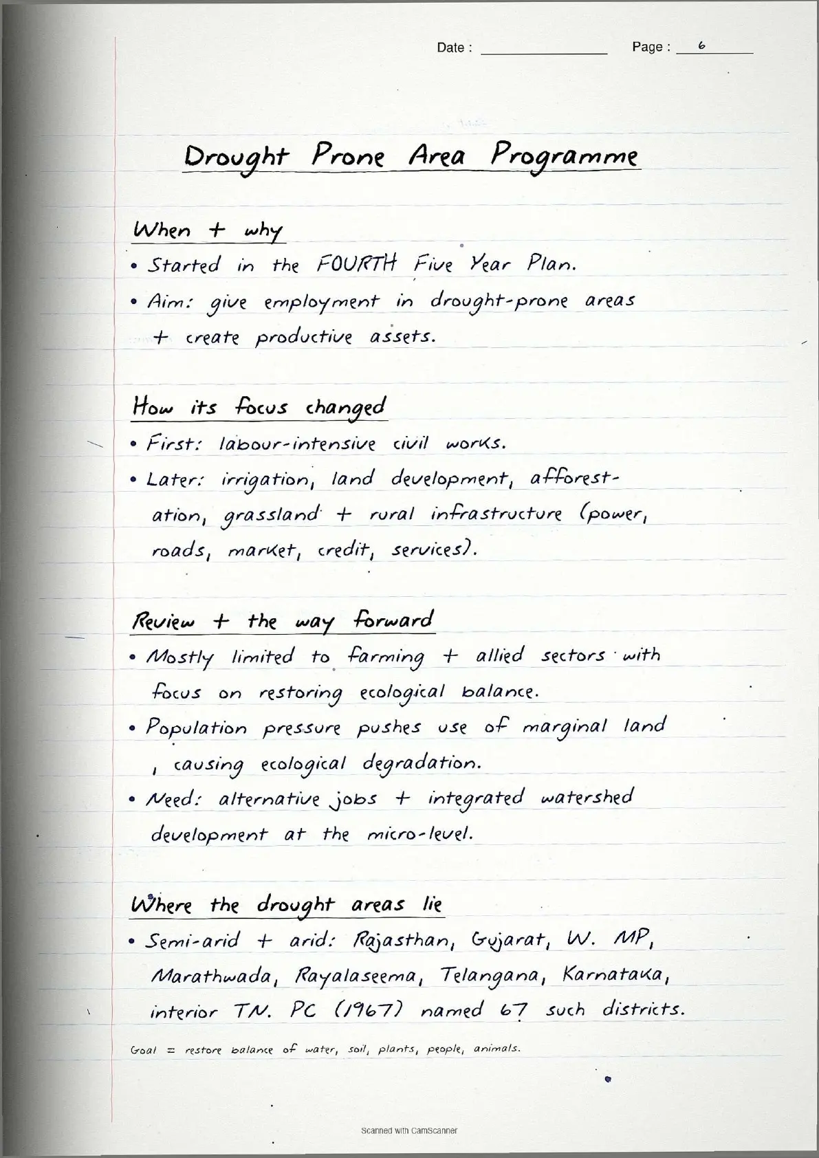
| Page 2 | Hill Area Development Programme (5th Plan, 15 districts), Drought Prone Area Programme (4th Plan, 67 districts), watershed approach. | 6 minutes |
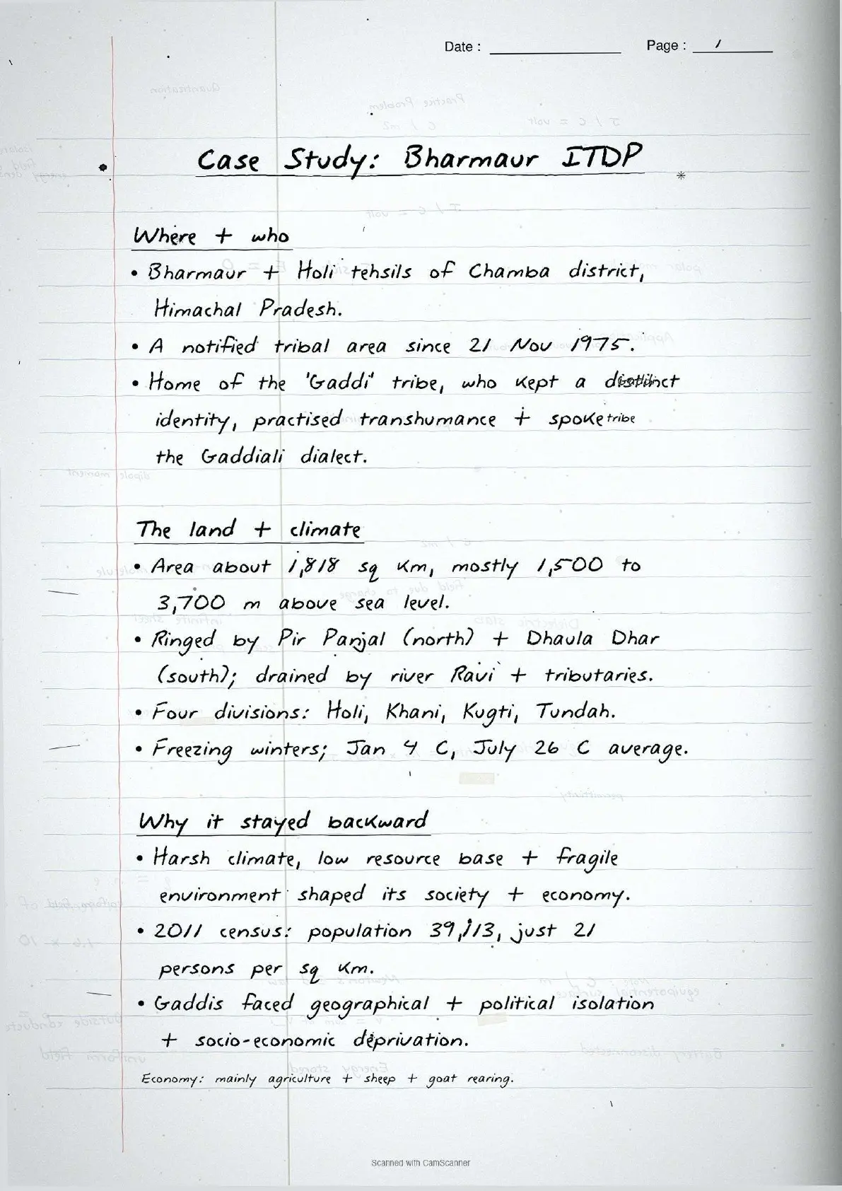
| Page 3 | ITDP Bharmaur case study: location, Gaddi community, infrastructure, literacy rise (1.88% to 65%), social benefits and limitations. | 6 minutes |
| Page 4 | Sustainable development concept, Brundtland Report 1987, Indira Gandhi Canal facts, command area stages, positive and negative impacts. | 5 minutes |
| Page 5 | Seven measures for sustainable development in IGCCA, ecological, social and economic sustainability pillars. | 4 minutes |
Source: HUMAN-AT-EASE on YouTube
Types of Planning: Sectoral and Regional
The chapter distinguishes two broad approaches to planning.
Sectoral planning
Sectoral planning means programmes for various sectors of the economy like agriculture, manufacturing, power and transport. The Planning Commission handled this until replaced by the NITI Aayog on 1 January 2015. It does not address regional inequalities.
Regional planning
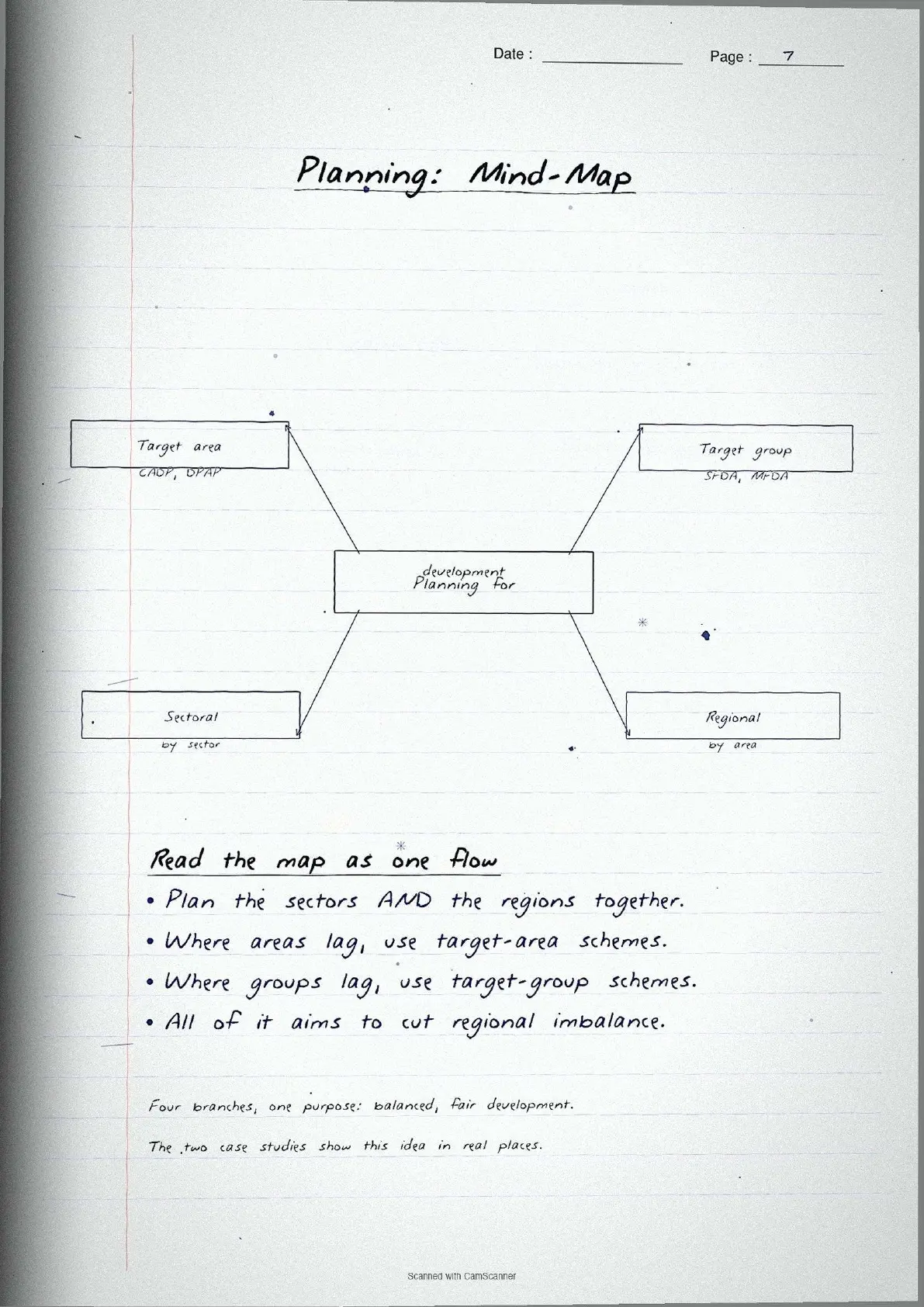
No country develops uniformly over space, so planners take a spatial perspective and draw plans to reduce regional imbalances. This is called regional planning.
Board exam tip: Sectoral planning = which sectors to develop. Regional planning = which areas are lagging and need special attention. CBSE tests whether students can separate the two cleanly.
Target Area Programmes at a Glance
After about fifteen years of planning, India found regional and social disparities were growing, so the Planning Commission introduced the target area and target group approaches for backward regions and weaker sections.
| Programme | Five Year Plan launched | Main objective |
|---|---|---|
| Command Area Development Programme | 4th Plan onwards | Improve irrigation management and on-farm water use in canal command areas. |
| Drought Prone Area Development Programme | 4th Five Year Plan | Provide employment in drought-prone areas and create productive assets through watershed development. |
| Desert Development Programme | 6th Five Year Plan | Control desertification, develop water resources, and restore ecological balance in arid regions. |
| Hill Area Development Programme | 5th Five Year Plan | Harness indigenous resources of hill areas through horticulture, animal husbandry, forestry and small industries. |
Target group programmes focused on communities: the Small Farmers (SFDA) and Marginal Farmers (MFDA) Development Agencies. The Drought Prone Area Programme is the most-tested: the Planning Commission (1967) identified 67 districts as drought-prone, and the strategy now emphasises integrated watershed development.
Case Study: ITDP in Bharmaur Tribal Region
The Bharmaur tribal region case study is the most-tested part of Chapter 6, asked about its social benefits and limitations.
Location and physical setting
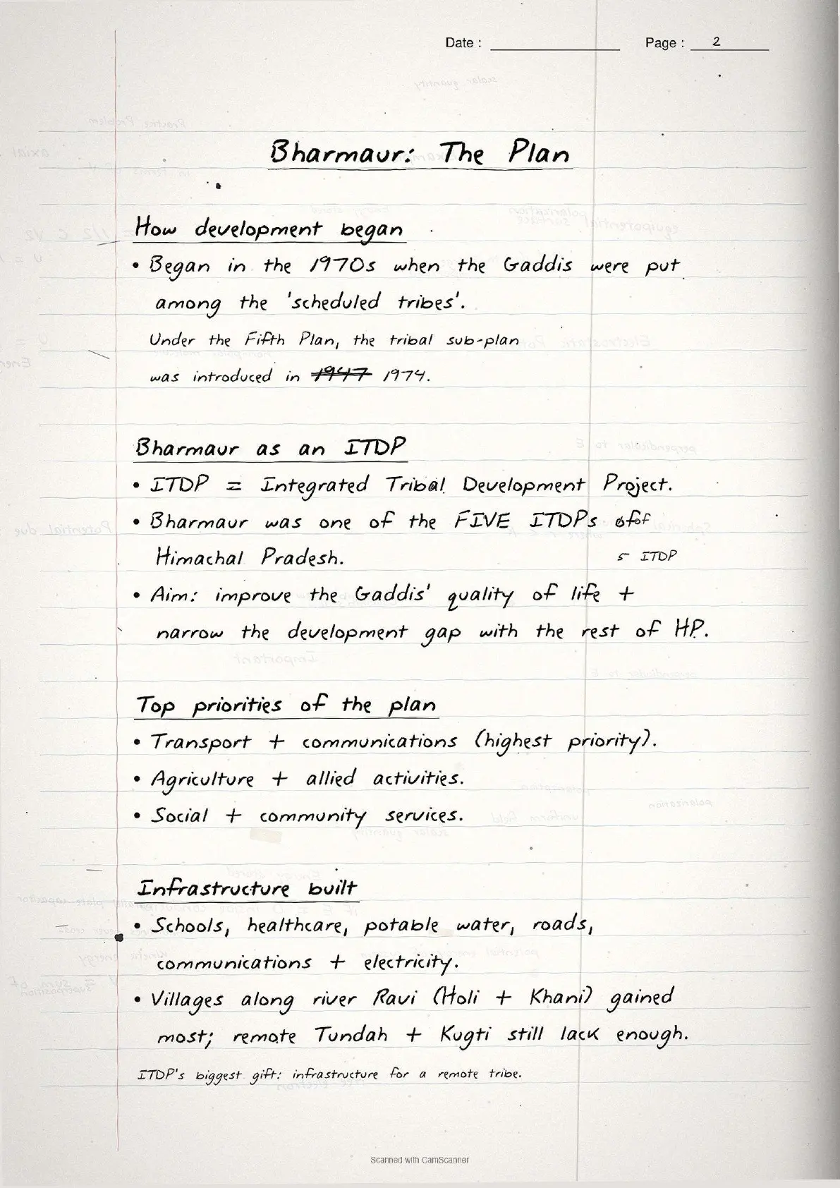
Bharmaur comprises Bharmaur and Holi tehsils of Chamba district, Himachal Pradesh, notified as a tribal area on 21 November 1975. It lies mostly between 1,500 m and 3,700 m above sea level and is drained by the Ravi.
The Gaddi community and the ITDP
Bharmaur is home to the Gaddi tribal community, who kept a distinct identity through transhumance (seasonal migration of livestock) and historically faced isolation and deprivation. Under the Fifth Five Year Plan, the tribal sub-plan was introduced in 1974 and Bharmaur became one of the five Integrated Tribal Development Projects (ITDP) in Himachal Pradesh, prioritising transport, agriculture and social services.
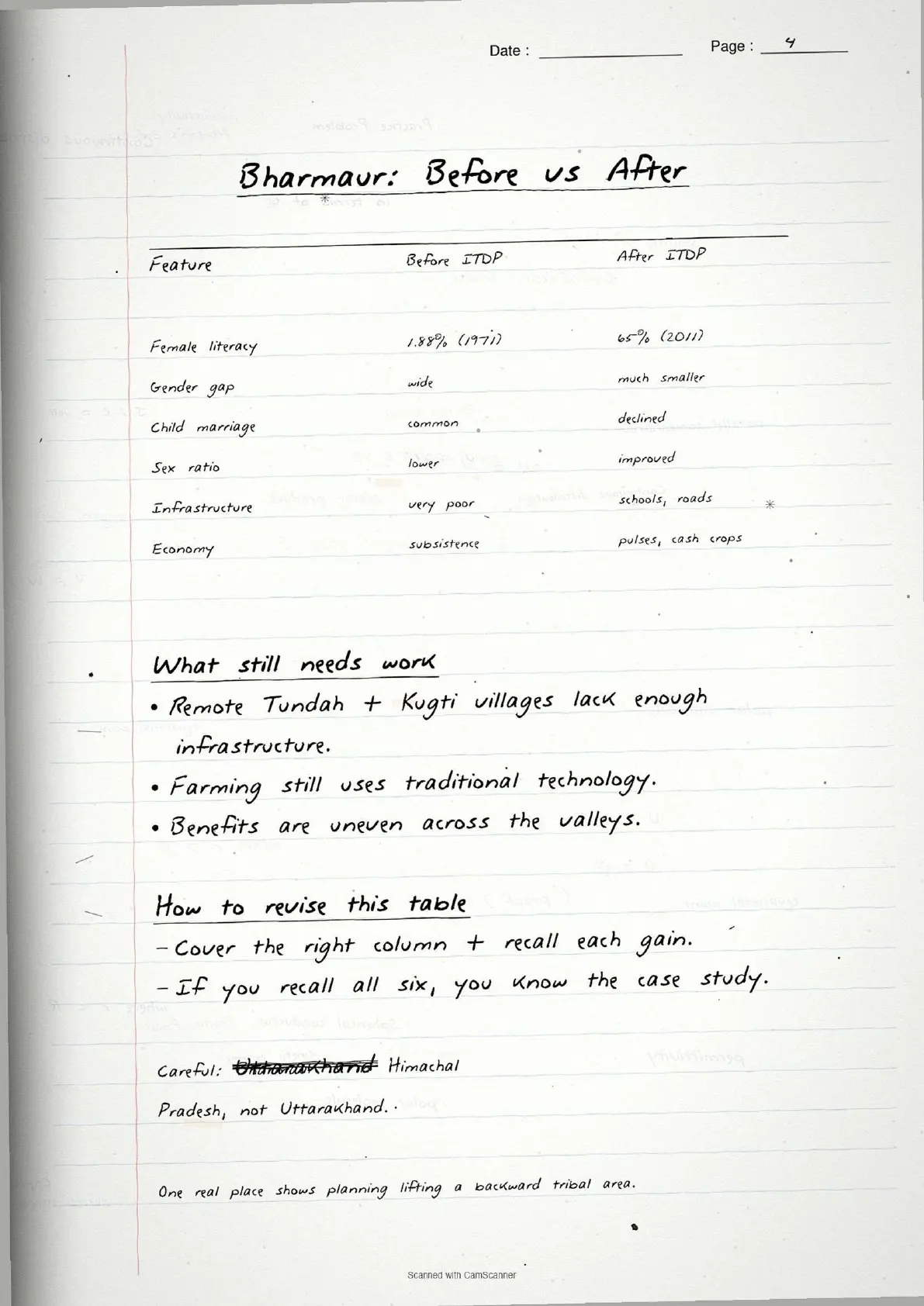
| Outcome dimension | Before ITDP | After ITDP (2011 data) |
|---|---|---|
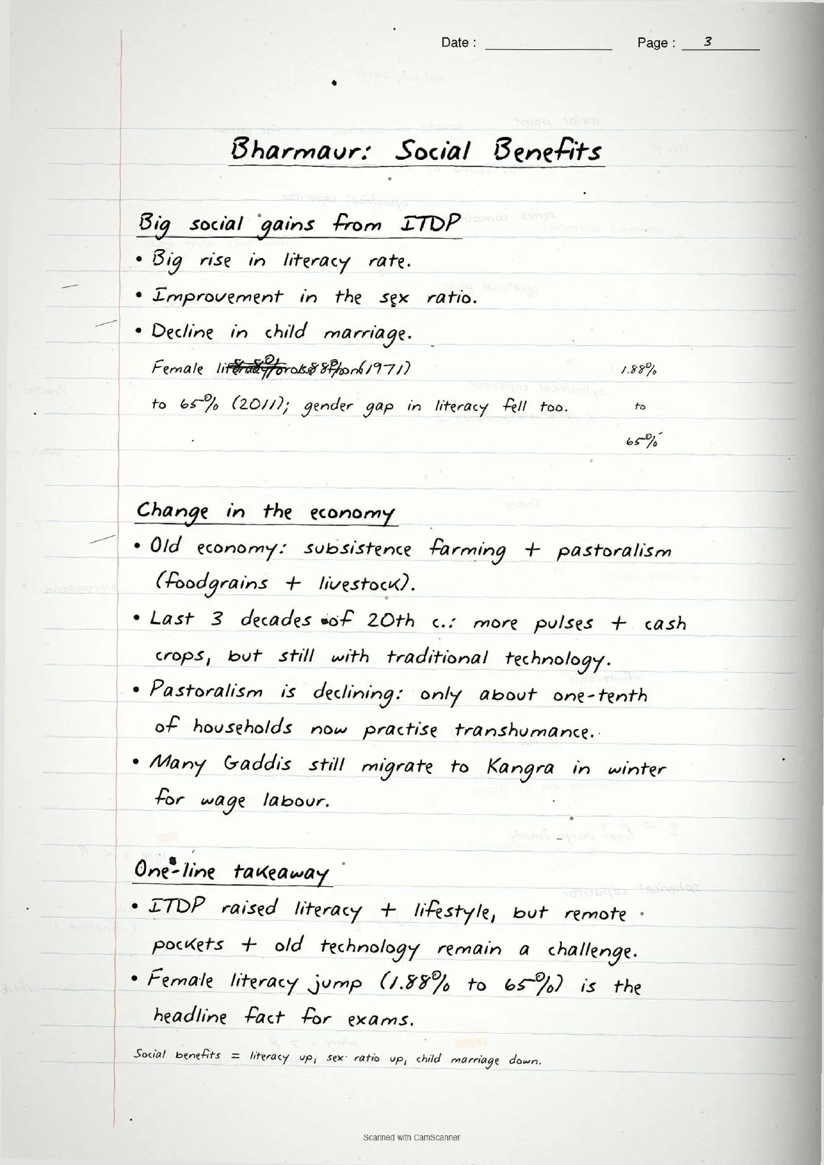
| Female literacy rate | 1.88% (1971) | 65% (2011) |
| Infrastructure | Limited roads, no schools or health centres in remote areas | Schools, healthcare, potable water, roads, electricity in Holi and Khani areas |
| Crop diversification | Subsistence foodgrains only (millets) | Pulses and cash crops added; wheat, cotton, groundnut introduced |
| Transhumance practice | Dominant livelihood | Only about one-tenth of households still practise it |
| Sex ratio and child marriage | Unfavourable ratio; child marriage common | Improved sex ratio; child marriage declined significantly |
Despite these gains, the remote Tundah and Kugti areas still lack infrastructure, and many Gaddis still migrate to Kangra in winter for wage labour. CBSE often asks for both the achievements and the remaining gaps.
Sustainable Development: Concept and Brundtland Definition
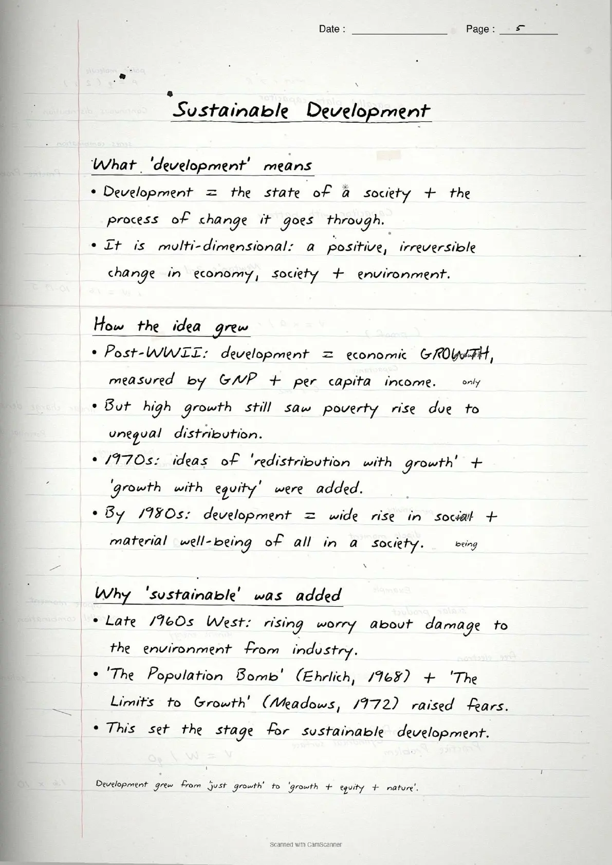
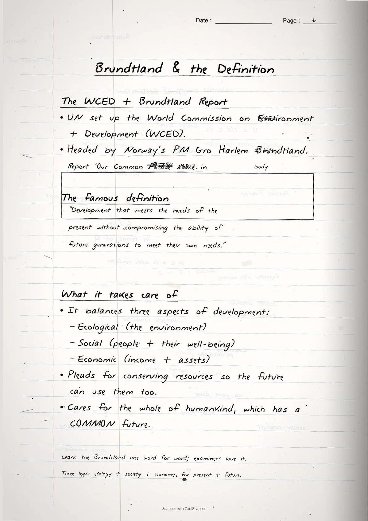
Sustainable development grew out of environmental awareness in the late 1960s, when the UN set up the World Commission on Environment and Development (WCED) chaired by Gro Harlem Brundtland. Its report Our Common Future (1987) defined sustainable development as "development that meets the needs of the present without compromising the ability of future generations to meet their own needs." It rests on three pillars:
- Ecological sustainability: conservation of natural resources, biodiversity and ecosystems.
- Social sustainability: equitable distribution of benefits; inclusion of marginalised communities.
- Economic sustainability: a diversified economic base, not dependent on one fragile sector.
Case Study: Indira Gandhi Canal Command Area
The Indira Gandhi Canal case study shows sustainable development challenges in practice, tested as MCQ data and long-answer questions.
Key facts about the canal
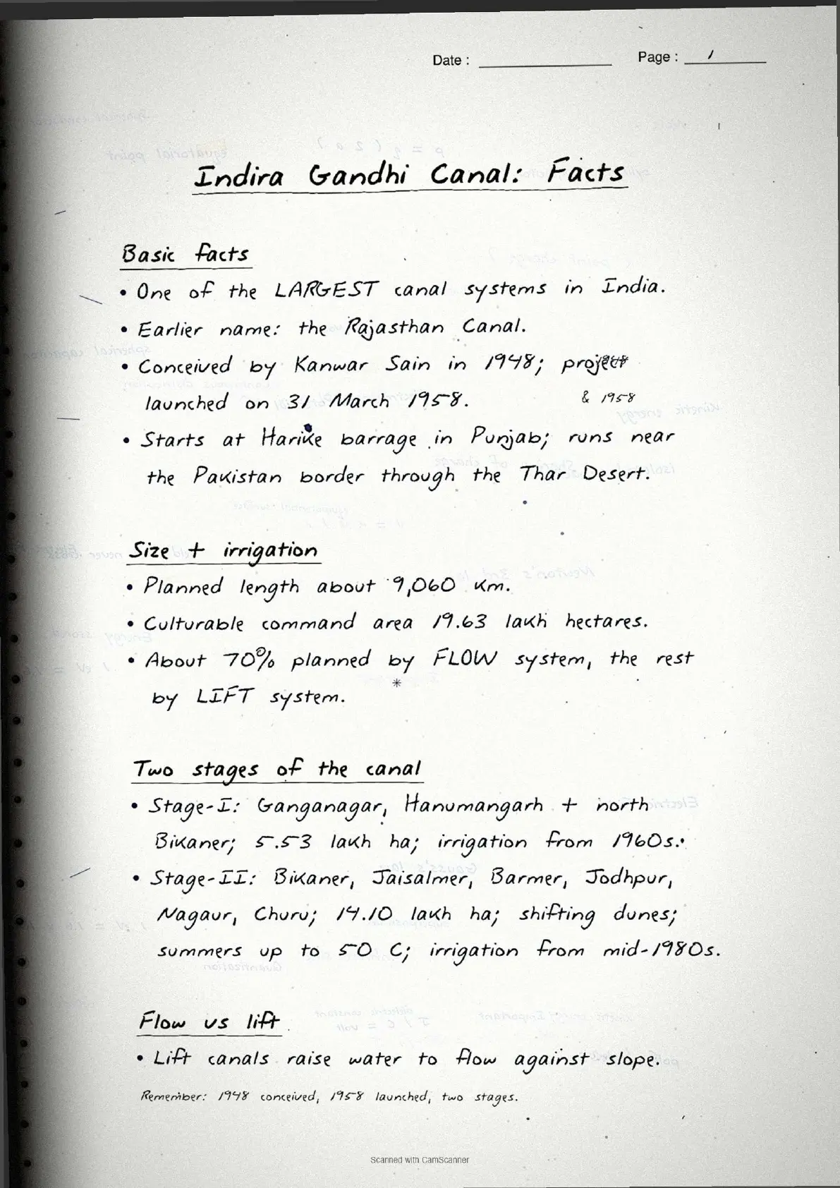
The Indira Gandhi Canal (formerly the Rajasthan Canal) was launched on 31 March 1958, originates at the Harike Barrage in Punjab, and runs through the Thar Desert of Rajasthan parallel to the Pakistan border.
| Fact | Figure |
|---|---|
| Total planned length of canal system | 9,060 km |
| Total culturable command area | 19.63 lakh hectares |
| Stage-I command area (Ganganagar, Hanumangarh, N. Bikaner) | 5.53 lakh hectares |
| Stage-II command area (Bikaner, Jaisalmer, Barmer, Jodhpur, Nagaur, Churu) | 14.10 lakh hectares |
| Flow irrigation (share of command area) | About 70% |
| Lift irrigation (share of command area) | About 30% |
| Stage-I irrigation started | Early 1960s |
| Stage-II irrigation started | Mid-1980s |
Positive and negative impacts of canal irrigation
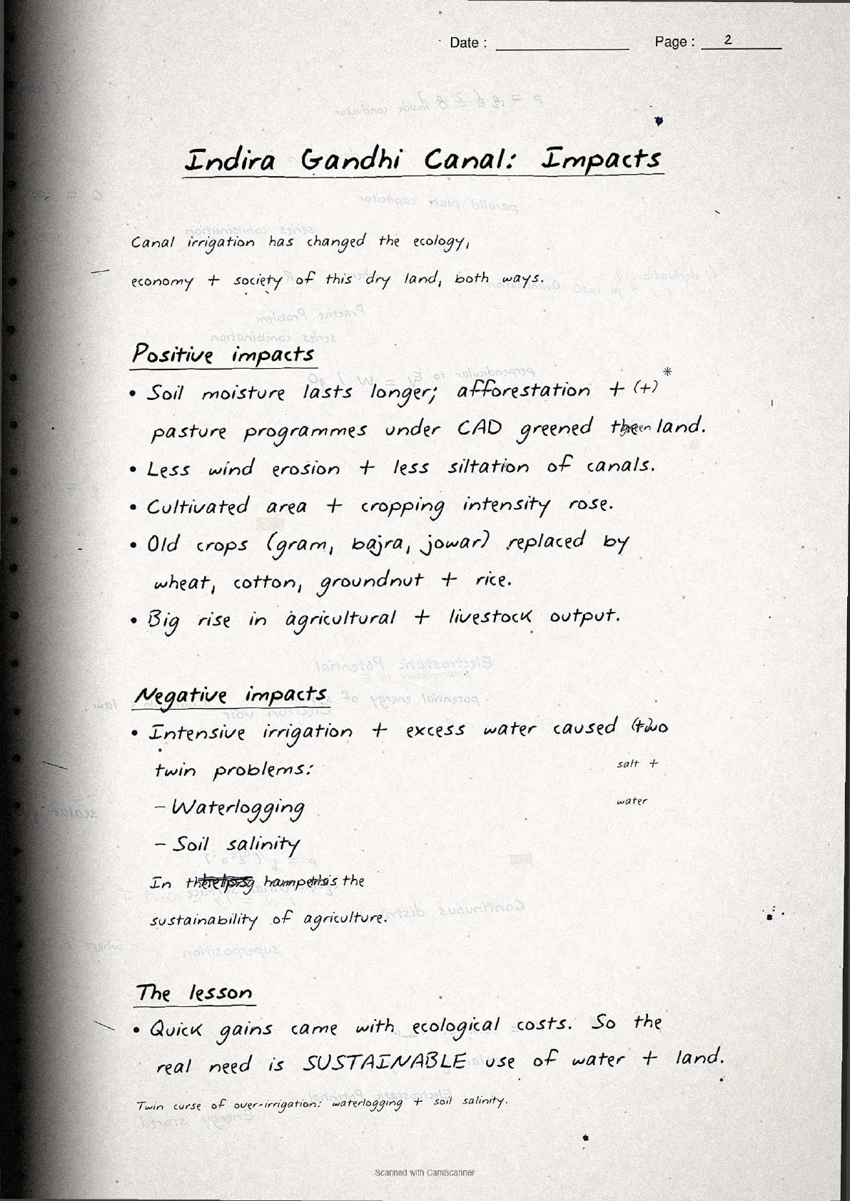
Canal irrigation transformed the Thar Desert but also created problems. Positive impacts: greening of land, afforestation under CAD (Command Area Development), reduced wind erosion, and a big rise in cultivated area, with traditional crops replaced by wheat, cotton, groundnut and rice. Negative impacts: waterlogging and soil salinity from intensive irrigation.
Seven measures for sustainable development in the command area
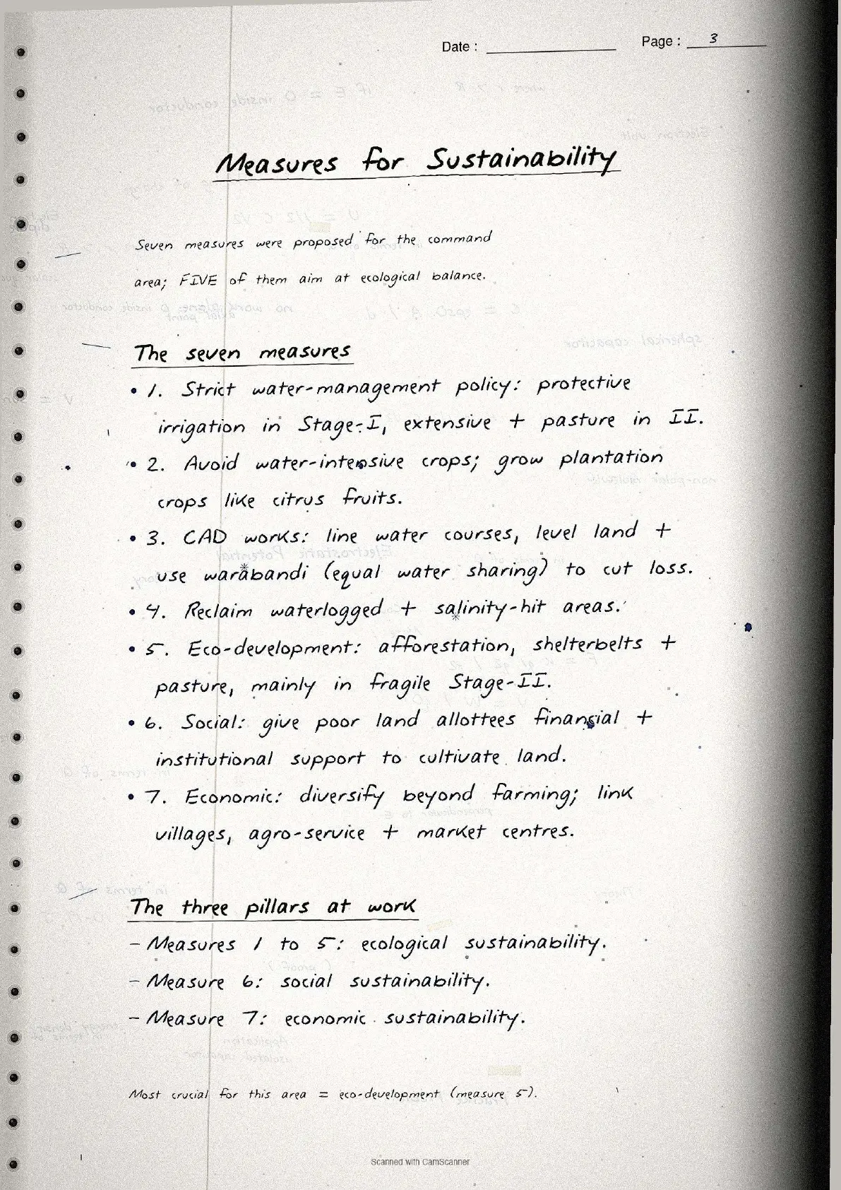
These seven measures are the direct NCERT source for the 150-word board question:
- Strict water management policy: protective irrigation in Stage-I; extensive irrigation and pasture development in Stage-II.
- Avoid water-intensive crops: encourage plantation crops like citrus instead of paddy.
- CAD programmes: lining of water courses, land levelling and the warabandi system to cut water losses.
- Reclaim waterlogged and saline areas through drainage and soil treatment.
- Eco-development: afforestation, shelterbelt and pasture development, especially in Stage-II.
- Social sustainability: financial and institutional support to poorer land allottees.
- Economic sustainability: diversify beyond agriculture; link villages, agro-service centres and markets.
Common Mistakes Highlighted in the Notes
The five repeat-offender mistakes CBSE examiners flag on planning and sustainable development class 12 questions:
- Confusing ITDP with SFDA/MFDA. ITDP is an area programme (Bharmaur); SFDA/MFDA are target group programmes for small and marginal farmers.
- Getting the Brundtland year wrong. "Our Common Future" was published in 1987, not 1972 (Limits to Growth) or 1992 (Rio Earth Summit).
- Mixing Stage-I and Stage-II areas. Stage-I is Ganganagar, Hanumangarh and northern Bikaner (5.53 lakh ha); Stage-II is Jaisalmer, Barmer, Jodhpur, Nagaur and Churu (14.10 lakh ha).
- Listing only positive impacts of canal irrigation. CBSE asks for both sides; forgetting waterlogging and soil salinity costs about 2 marks.
- Omitting sustainability measures. The full NCERT list has seven; the 150-word question expects at least five.
Each mistake carries a one-line "remember this" note. The Brundtland year hook reads "1987 = Brundtland; 1972 = Limits to Growth; 1992 = Rio Summit".
Previous Year Question Trends
Chapter 6 has carried a stable 6 to 10 marks in recent CBSE Class 12 Geography board papers, across MCQs, short and long-answer questions.
| Year | Question asked | Marks | Notes page to revise |
|---|---|---|---|
| 2025 | Define sustainable development + social benefits of ITDP in Bharmaur | 2 + 3 | Page 4 + Page 3 |
| 2024 | MCQ: ITDP stands for... + measures for sustainability in IGCCA (5 measures) | 1 + 5 | Page 3 + Page 5 |
| 2023 | Distinguish sectoral and regional planning + Drought Prone Area Programme | 2 + 3 | Page 1 + Page 2 |
| 2022 | Brundtland Report definition + positive impacts of Indira Gandhi Canal | 2 + 3 | Page 4 |
| 2021 | Hill Area Development Programme + ecological sustainability measures | 3 + 3 | Page 2 + Page 5 |
The ITDP Bharmaur case study and the seven IGCCA sustainability measures appear most often. Learn both case studies with their key statistics to pick up 6 to 8 marks.
Other Resources for Class 12 Geography Chapter 6 Planning and Sustainable Development
Pair these handwritten notes with the matching NCERT Solutions, typed Notes and NCERT Book chapter.
| Resource | What it covers | Open |
|---|---|---|
| Handwritten Notes | Topper's handwritten revision pages for last-mile board exam prep. | You are here |
| NCERT Solutions | Step-by-step answers to all exercise questions with detailed explanations. | Class 12 Geography Chapter 6 NCERT Solutions |
| Notes | Concept-first typed revision notes with definitions, case studies and common mistakes. | Class 12 Geography Chapter 6 Notes |
| NCERT Book PDF | Official NCERT India People and Economy Chapter 6 textbook in PDF form. | Class 12 Geography Chapter 6 NCERT Book PDF |
| Subject Hub | All chapters of Class 12 Geography with every resource in one place. | Class 12 Geography Subject Hub |
All Chapters Handwritten Notes for Class 12 Geography India People and Economy
Related Links: Handwritten notes for other chapters of Class 12 Geography IPE.
| Chapter | Topic | Handwritten Notes link |
|---|---|---|
| Chapter 1 | Population Distribution, Density, Growth and Composition | Class 12 Geography Chapter 1 IPE Handwritten Notes |
| Chapter 2 | Human Settlements | Class 12 Geography Chapter 2 IPE Handwritten Notes |
| Chapter 3 | Land Resources and Agriculture | Class 12 Geography Chapter 3 IPE Handwritten Notes |
| Chapter 4 | Water Resources | Class 12 Geography Chapter 4 IPE Handwritten Notes |
| Chapter 5 | Mineral and Energy Resources | Class 12 Geography Chapter 5 IPE Handwritten Notes |
| Chapter 6 | Planning and Sustainable Development in Indian Context | You are here |
| Chapter 7 | Transport and Communication | Class 12 Geography Chapter 7 IPE Handwritten Notes |
| Chapter 8 | International Trade | Class 12 Geography Chapter 8 IPE Handwritten Notes |
| Chapter 9 | Geographical Perspective on Selected Issues and Problems | Class 12 Geography Chapter 9 IPE Handwritten Notes |
Planning and Sustainable Development Class 12 Handwritten Notes FAQs
Ques. What are these planning and sustainable development class 12 handwritten notes meant to be used for?
Ans. They are a topper's handwritten revision file that compresses the full NCERT Chapter 6 of Class 12 Geography India People and Economy into 4 to 5 pages of concept boxes, case study summaries and margin-callout common mistakes. Students use the file for last-mile revision in the 24 hours before the board paper, paired with the typed Notes for concept building and the NCERT Solutions for written-answer practice.
Ques. What is the Brundtland definition of sustainable development for Class 12 Geography?
Ans. The Brundtland definition of sustainable development, from the 1987 report "Our Common Future" published by the World Commission on Environment and Development (WCED), states: "development that meets the needs of the present without compromising the ability of future generations to meet their own needs." This definition is the standard CBSE answer for any 2-mark question on defining sustainable development. The handwritten notebook prints this definition inside a double-underlined box on Page 4 with the year 1987 circled beside it, since getting the year right is a common mistake.
Ques. What are the social benefits of ITDP in the Bharmaur tribal region?
Ans. The social benefits of ITDP in the Bharmaur tribal region include: a dramatic increase in female literacy from 1.88% in 1971 to 65% in 2011; improvement in the sex ratio; a decline in child marriage; access to schools, healthcare facilities, potable water, roads and electricity (mainly in Holi and Khani areas); and a decline in gender inequality in education levels. Crop diversification also improved food security. The handwritten notes capture all five benefits as numbered bullets on Page 3, which is the standard CBSE format for a 3-mark short-answer question.
Ques. What is the difference between sectoral planning and regional planning in Class 12 Geography?
Ans. Sectoral planning means formulating and implementing programmes for the development of various sectors of the economy such as agriculture, manufacturing, power and transport. It focuses on what to produce across the whole nation. Regional planning, by contrast, recognises that economic development is uneven across space and draws plans specifically to reduce regional imbalances. It takes an area-specific approach, focusing on why some regions lag behind and what targeted interventions can close the gap. CBSE typically tests this distinction as a 2-mark question, and the handwritten notebook draws both definitions as side-by-side boxes on Page 1.
Ques. What are the measures for promotion of sustainable development in the Indira Gandhi Canal Command Area?
Ans. The seven measures for sustainable development in the Indira Gandhi Canal Command Area are: (1) strict implementation of water management policy with protective irrigation in Stage-I and extensive irrigation in Stage-II; (2) avoid water-intensive crops and encourage plantation crops like citrus fruits; (3) effective implementation of CAD programmes including lining of water courses, land development and the warabandi system; (4) reclamation of waterlogged and saline areas; (5) eco-development through afforestation, shelterbelt plantation and pasture development in Stage-II; (6) financial and institutional support for land allottees with poor economic backgrounds; and (7) diversification of economic base beyond agriculture to build functional linkages between villages, agro-service centres and market centres. The handwritten notes list all seven on Page 5 in numbered form.
Ques. What are the positive and negative impacts of irrigation in the Indira Gandhi Canal Command Area?
Ans. Positive impacts: greening of desert land through increased soil moisture; afforestation and pasture development under CAD reducing wind erosion; expansion of cultivated area; replacement of subsistence crops (bajra, jowar, gram) with commercial crops (wheat, cotton, groundnut, rice); increase in agricultural and livestock productivity. Negative impacts: intensive irrigation has led to waterlogging and soil salinity in the command area, reducing soil productivity in the long run and threatening agricultural sustainability. CBSE specifically asks for both sides, and the handwritten notebook presents them as a two-column pros-and-cons table on Page 4 to make the contrast stick in memory.
Ques. How long does it take to revise these planning and sustainable development notes class 12?
Ans. The full handwritten notes file is designed for a 21-minute first revision pass, a 14-minute targeted pass and a 7-minute final pass right before the exam. Students who already have the chapter under their belt finish the full file in under 20 minutes. The Page 3 ITDP social benefits block and the Page 5 seven sustainability measures list together take about 11 to 13 minutes to revise and cover the majority of marks the chapter typically carries in the CBSE Class 12 Geography board paper.
Ques. Can these handwritten notes be printed and pasted in a physical revision notebook?
Ans. Yes, and that is the recommended use pattern. The PDF is sized for A4 printing, with each page fitting cleanly inside a standard notebook page. Toppers in the 2026 Class 12 Geography student poll reported that printing these pages and pasting them into their revision notebook added about 2 marks on the 5-mark long-answer question.
Ques. Is the Class 12 Geography syllabus for planning and sustainable development changing in 2026-27?
Ans. No major changes in 2026-27. The India People and Economy textbook chapter structure is unchanged for the current cycle, and the CBSE marking scheme continues to reward factual precision for case study questions (ITDP Bharmaur and Indira Gandhi Canal) and clear definition recall for the Brundtland concept. These planning and sustainable development class 12 handwritten notes for the 2026-27 cycle are aligned to the unchanged textbook and the latest CBSE sample paper released for the 2026 boards.
Ques. Who are the Gaddis and why are they important for the Bharmaur ITDP case study?
Ans. The Gaddis are a tribal community inhabiting the Bharmaur region of Chamba district, Himachal Pradesh. They maintained a distinct Himalayan identity through transhumance (seasonal migration of livestock between high-altitude pastures in summer and lower valleys in winter) and the Gaddiali dialect. The Gaddis are important to the ITDP case study because the entire purpose of the Bharmaur Integrated Tribal Development Project (launched under the 5th Five Year Plan in 1974) was to improve the quality of life of this specific community, which had historically suffered from geographical isolation, political marginalisation and socio-economic deprivation. Their transformation over four decades (female literacy rising from 1.88% to 65%) shows what a well-implemented tribal sub-plan can achieve.
Ques. What is the NITI Aayog and how does it relate to planning in Class 12 Geography?
Ans. The NITI Aayog (National Institution for Transforming India) replaced the Planning Commission on 1 January 2015. The Planning Commission had been responsible for formulating Five Year Plans at the Centre, state and district levels since Independence. The NITI Aayog was set up with the objective of involving states more actively in economic policy making and providing strategic and technical advice to both the Central Government and State governments. In the context of Class 12 Geography Chapter 6, the NITI Aayog represents the shift from centralised planning to decentralised multi-level planning. The handwritten notes flag this change as a boxed "important fact" on Page 1 since it appears in CBSE board questions about the evolution of planning in India.



Comments