




These Class 12 Geography Chapter 7 Transport and Communication notes cover every NCERT definition, road, rail, water and air transport, pipelines, and mass and satellite communication, aligned to the 2026-27 syllabus. Built for night-before revision.
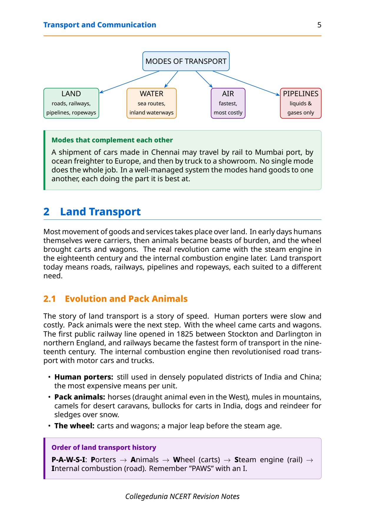
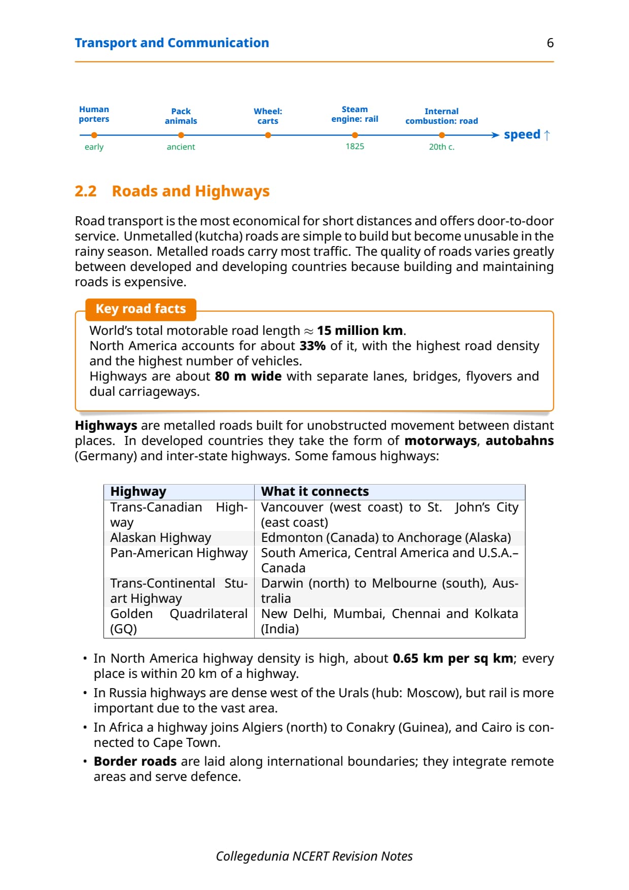
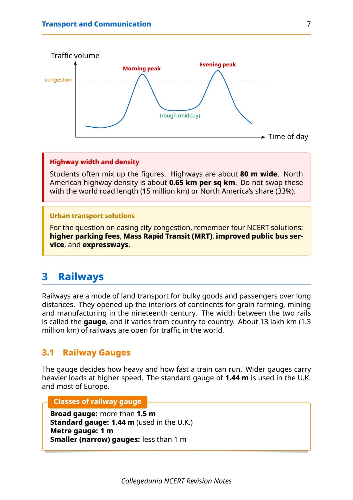
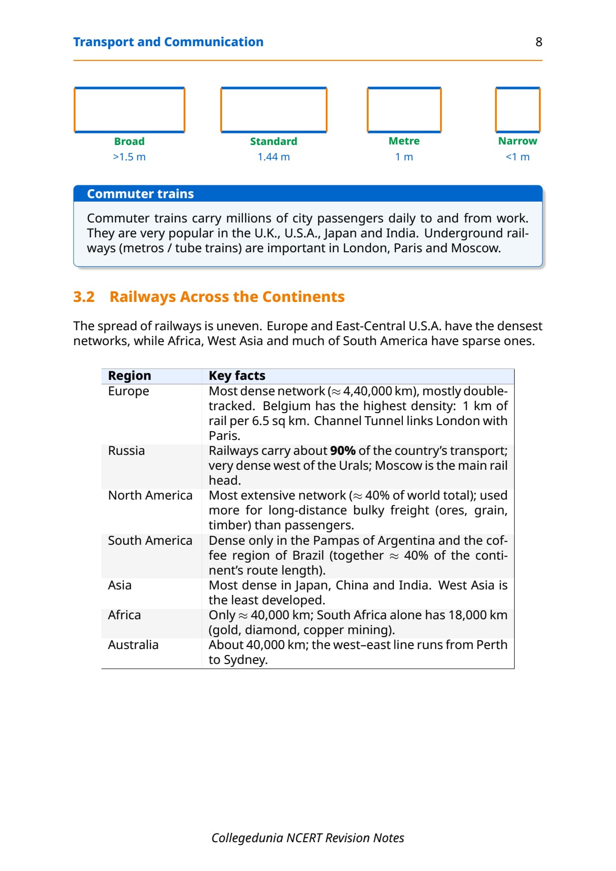
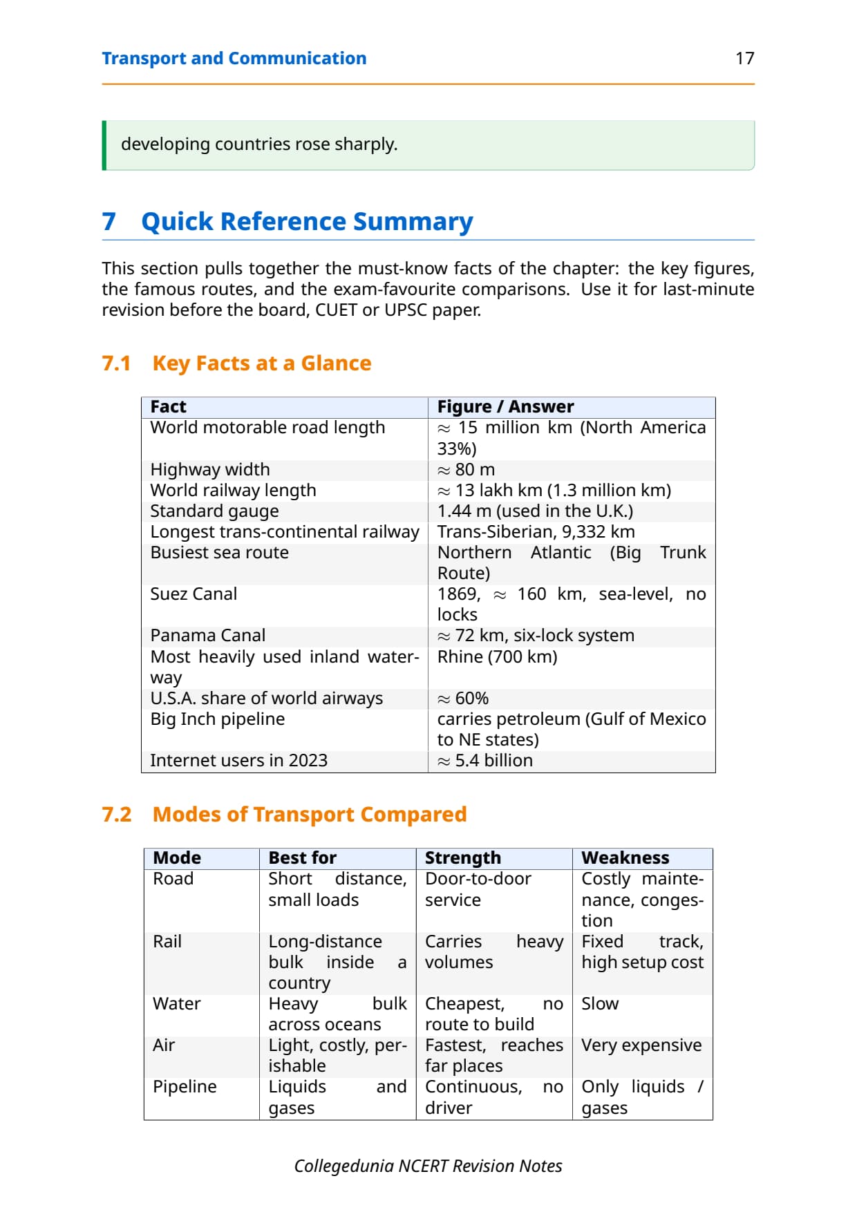
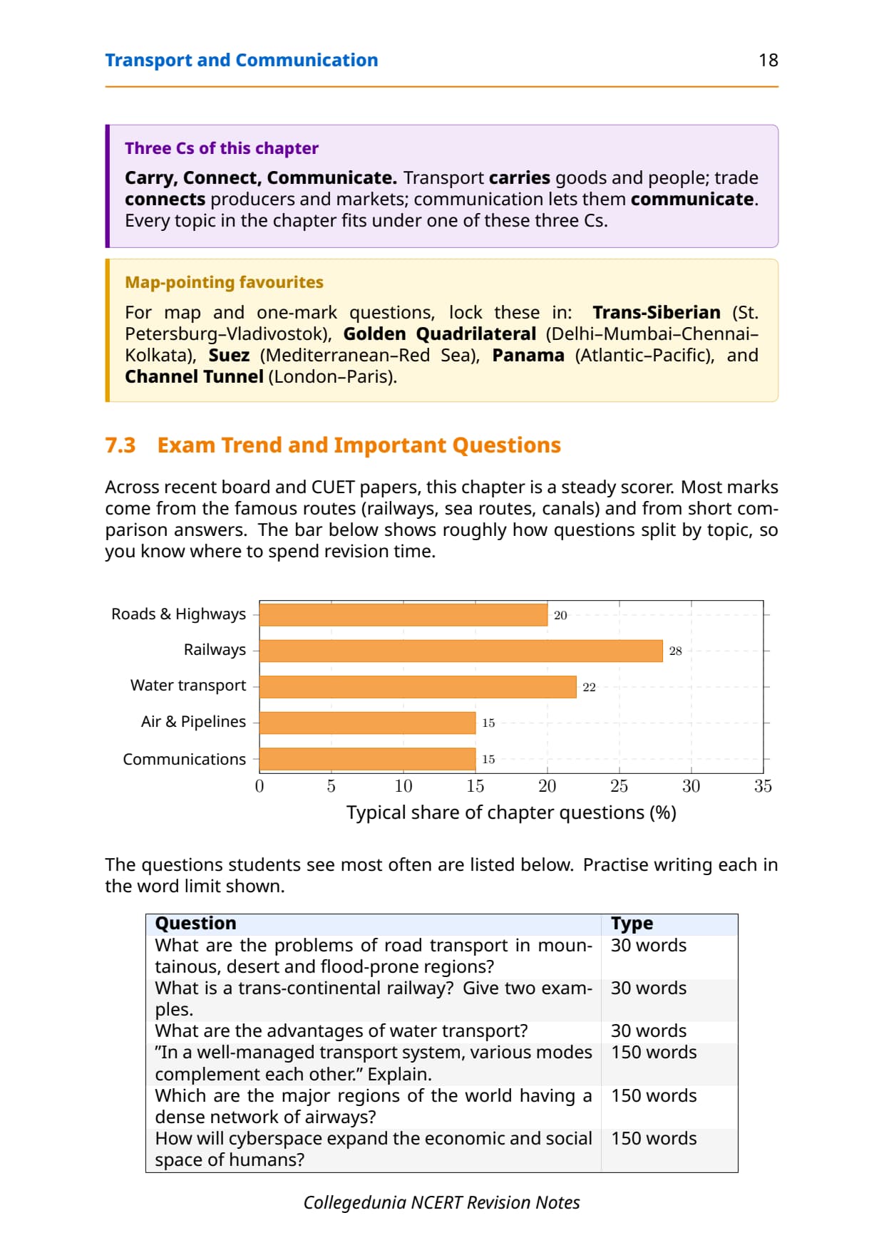
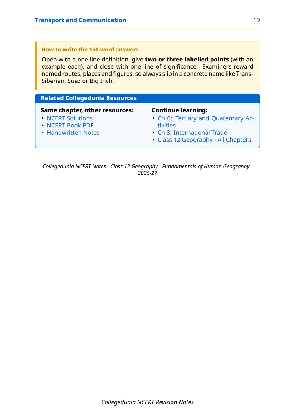

- Concept-first revision: the five transport modes, the Golden Quadrilateral and NS/EW corridors, and the Indian Railways zone system.
- Personal (internet, e-mail) and mass communication (radio, TV, satellite), including INSAT and IRS.
- Cross-pointers to the matching NCERT Solutions, Handwritten Notes and NCERT Book PDF.
These notes are written by Collegedunia geography experts, mapped to the 2026-27 NCERT India: People and Economy textbook and the last five years of CBSE and CUET question patterns.
Student Feedback
74% of Class 12 students found telling National Highways from State Highways and other road categories the most confusing area, and 3 out of 4 rated the Golden Quadrilateral details and the railway zone table most worth revising.
Source: 2026-27 Class 12 Geography student poll, 10,180 CBSE students.
Quick Concept Recap: Transport and Communication at a Glance
Chapter 7 explains how goods, people and information move across India, through five transport modes (roads, railways, water, air, pipelines) and two communication types (personal and mass). India has one of the world's largest road networks (62.16 lakh km) and 18 railway zones; about 95% of foreign trade by volume moves by sea; INSAT and IRS are the two satellite systems to know. The tables carry the detail.
Read these notes first, then use the matching NCERT Solutions for Chapter 7 for drill.
Source: Magnet Brains on YouTube
Key Definitions for Transport and Communication Class 12
Every theory question begins with a definition, in the one-line form CBSE markers expect.
| Term | One-line definition | NCERT section pointer |
|---|---|---|
| Transport | The movement of goods, commodities and people from one place to another, linking the site of production with the site of consumption. | Chapter 7 intro |
| National Highways (NH) | Roads constructed and maintained by the Central Government for inter-state transport, movement of defence material and connectivity between state capitals, major cities, ports and railway junctions. | Road Transport section |
| State Highways (SH) | Roads constructed and maintained by state governments, linking state capitals with district headquarters and important towns; connected to National Highways. | Road Transport section |
| Golden Quadrilateral | A 5,846-km long 4/6-lane high-density traffic corridor built by NHAI connecting India's four metro cities of Delhi, Mumbai, Chennai and Kolkata. | NHAI projects section |
| Border Roads Organisation (BRO) | An agency established in May 1960 for construction and maintenance of strategically important roads along the northern and north-eastern boundaries of India; also undertakes snow clearance. | Other Roads section |
| Inland Waterways | Rivers, canals, backwaters and creeks used for navigation within the country; the National Waterway No. 1 runs along the Ganga between Haldia and Prayagraj. | Water Transport section |
| Pipeline Transport | The most convenient and efficient mode for transporting liquids (crude oil, petroleum products) and gases over long distances; solids can also be transported after converting to slurry. | Pipelines section |
| Communication | The process of exchanging ideas, views and messages between people or from one place to another using various means including print, electronic and satellite media. | Communication Networks section |
| INSAT | Indian National Satellite System; established in 1983 as a multi-purpose satellite system for telecommunication, meteorological observation and data services. | Satellite Communication section |
| IRS | Indian Remote Sensing Satellite System; became operational with the launch of IRS-IA in March 1988; collects data in several spectral bands for natural resource management. | Satellite Communication section |
| NHAI | National Highways Authority of India; operationalised in 1995 as an autonomous body under the Ministry of Surface Transport for development, maintenance and operation of National Highways. | National Highways section |
| Akashwani | The name given to All India Radio in 1957; started broadcasting in India in 1923 by the Radio Club of Bombay, brought under government control in 1930. | Mass Communication section |
These cover most one-mark and 3-mark theory questions, so learn them first.
Road Transport: National Highways, NHAI Projects and Rural Roads
India has the world's second largest road network (about 62.16 lakh km). About 85% of passenger traffic and 70% of freight travel by road, the most used mode.
Classification of Roads
Roads fall into five categories. The table gives the key data CBSE asks about.
| Road Type | Length (2020) | Maintained by | Key fact for exam |
|---|---|---|---|
| National Highways | 1,36,440 km | Central Government / NHAI | Only 2% of total road length but carry 40% of road traffic |
| State Highways | 1,76,818 km | State governments | Connect state capitals to district HQs and important towns |
| Rural Roads | About 80% of total | Panchayats / State | Vital for rural connectivity; density varies with terrain |
| District Roads | Part of Other Roads | District authorities | Link district HQs to other important nodes |
| Border/International Roads | Strategic lengths | BRO / Central Govt | BRO built roads at avg 4,270 m altitude; Atal Tunnel (9.02 km) is world's longest highway tunnel |
Major NHAI Highway Projects
NHAI (operationalised 1995) runs four major corridor projects CBSE tests in 3-mark and 6-mark questions.
- Golden Quadrilateral: 5,846-km 4/6-lane corridor, Delhi-Mumbai-Chennai-Kolkata; cuts time, distance and cost.
- North-South Corridor: 4,076 km, Srinagar to Kanniyakumari (with Cochin-Salem Spur).
- East-West Corridor: 3,640 km, Silchar (Assam) to Porbandar (Gujarat).
- Bharatmala Pariyojana: about 26,000 km of Economic Corridors, plus ring roads and bypasses.
Tip: The common question is "Explain the significance of the Golden Quadrilateral": mention distance, time, cost and the four cities.
Indian Railways: Zones, Development and Significance
Indian Railways is one of the world's largest and busiest networks, carrying millions of passengers and tonnes of freight daily. The chapter covers its history, zone system and strategic importance.
Why railways matter for India
Railways carry large volumes over long distances at lower cost per unit than road, especially bulk goods like coal, iron ore and grain, and are the backbone of inter-city travel.
- Historical start: first line laid in 1853 between Mumbai and Thane (34 km).
- Zone system: 18 zones, each with its own headquarters (Table 7.2).
- Important nodes: Bengaluru, Hyderabad, Delhi, Kanpur and Patna.
- Limitations: difficult terrain and ecological sensitivity limit expansion in the north-east, hills and forests.
Railway Zones Quick Reference
Know at least the Central (Mumbai CST), Western (Mumbai Church Gate), Northern (Delhi), Southern (Chennai), Eastern (Kolkata) and North Eastern (Gorakhpur) zones for objective questions.
Water Transport and Air Transport in India
Water and air transport handle the highest-value cargo and fastest movement. Water transport splits into inland waterways and oceanic routes; air transport runs via the AAI.
Inland Waterways
India has about 14,500 km of navigable inland waterways. The IWAI maintains three declared National Waterways:
- National Waterway No. 1: the Ganga between Haldia and Prayagraj (1,620 km), directly tested in CBSE MCQs.
- National Waterway No. 2: the Brahmaputra between Sadiya and Dhubri (891 km).
- National Waterway No. 3: the West Coast Canal between Kottapuram and Kollam (205 km).
Oceanic Routes and Ports
India has a coastline of about 7,517 km, with 12 major and about 200 minor ports. Oceanic routes carry about 95% by volume and 70% by value of foreign trade, and link the mainland with the Andaman and Nicobar Islands and Lakshadweep.
Air Transport
Air transport is the fastest mode, essential where mountains and deserts make surface travel slow. Key facts:
- First airmail: 1911, over 10 km between Prayagraj and Naini.
- Airport Authority of India (AAI): manages air traffic and aeronautical communication in Indian air space.
- UDAN scheme: Regional Connectivity Scheme by the Ministry of Civil Aviation to make regional air travel affordable.
- Pawan Hans: helicopter service used in hilly areas and mainly for the petroleum sector.
Pipelines and Oil and Gas Networks
Pipelines are the most efficient mode for liquids and gases over long distances, working 24 hours a day without driver fatigue or loading delays; even solids move as slurry.
Key pipeline networks in India
- Asia's first cross-country pipeline: 1,157 km from Naharkatiya (Assam) to Barauni refinery (Bihar) by Oil India Limited; extended to Kanpur in 1966.
- Hazira-Vijaipur-Jagdishpur (HVJ) pipeline: 1,700 km gas pipeline by GAIL, linking Mumbai High and Bassein gas fields with industry in western and northern India.
- GAIL network: expanded from 1,700 km to 18,500 km, expected to reach over 34,000 km as the Gas Grid.
- OIL (Oil India Limited): incorporated 1959; explores, produces and transports crude oil and gas.
Memory hook: GAIL built the HVJ pipeline (1,700 km); OIL built the first cross-country pipeline (1,157 km, Naharkatiya to Barauni). CBSE asks these figures in 1-mark questions.
Communication Networks: Radio, Television and Satellite Systems
Communication splits into personal (internet, e-mail) and mass communication (radio, TV, satellite). CBSE has asked 1-mark, 3-mark and 6-mark questions on it.
Personal Communication
The internet is the most effective personal communication system, used in urban areas for e-mail, e-commerce and low-cost information access, and underpins digital communication in India.
Mass Communication: Radio
Radio broadcasting started in 1923 by the Radio Club of Bombay, came under government control in 1930, became All India Radio in 1936 and Akashwani in 1957. It airs information, education and entertainment.
Mass Communication: Television
TV broadcasting began in Delhi in 1959, spread after 1972, and split from All India Radio as Doordarshan (DD) in 1976. After INSAT-IA enabled national TV (DD1), Common National Programmes reached remote areas.
Satellite Communication: INSAT and IRS
| System | Established | Purpose | Key application |
|---|---|---|---|
| INSAT | 1983 | Telecommunication, meteorological observation, data services | Weather forecasting, monitoring natural calamities, surveillance of border areas |
| IRS | March 1988 (IRS-IA) | Remote sensing in several spectral bands | Management of natural resources; data processed at NRSC, Hyderabad |
| PSLV | Developed by India | Polar Satellite Launch Vehicle; India's own satellite launching capability | Launches IRS satellites; reduces dependence on foreign launch vehicles |
Satellites broadcast TV and radio (INSAT) and power GPS, weather alerts and surveillance. CBSE has asked the INSAT vs IRS difference as a 3-mark question twice in five years.
Previous Year Question Trends from Chapter 7
Important questions follow a steady pattern. The table maps what CBSE has asked over the last five years.
| Year | Question type asked | Marks | Notes section to revise |
|---|---|---|---|
| 2025 | Golden Quadrilateral: route + significance + how it helps economic development | 5 | Road Transport section (NHAI projects) |
| 2024 | Difference between INSAT and IRS + MCQ on National Waterway No. 1 | 3 + 1 | Satellite Communication table + Inland Waterways |
| 2023 | Role of roads in economic development of India (150 words) | 5 | Road Transport section |
| 2022 | Chief means of transportation in India + factors affecting their development | 6 | Quick Concept Recap + all transport sections |
| 2021 | MCQ on first radio broadcast year + BRO establishment and function | 1 + 3 | Communication section + Key Definitions (BRO) |
The chapter carries an effective 7 to 10 marks per year across MCQs, short and long answers.
Other Resources for Class 12 Geography Chapter 7 Transport and Communication
Pair these notes with the matching resources below.
| Resource | What it covers | Open |
|---|---|---|
| Notes | Concept-first revision notes covering road, rail, water, air, pipeline transport and communication systems including INSAT and IRS. | You are here |
| NCERT Solutions | Step-by-step answers to all exercise questions with worked long-answer responses for the Golden Quadrilateral and railway development questions. | Class 12 Geography Chapter 7 NCERT Solutions |
| Handwritten Notes | A topper's genuine handwritten revision pages for last-minute board exam practice. | Class 12 Geography Chapter 7 Handwritten Notes |
| NCERT Book PDF | Official NCERT India: People and Economy Chapter 7 textbook in PDF form. | Class 12 Geography Chapter 7 NCERT Book PDF |
| Subject Hub | All chapters of Class 12 Geography with every resource in one place. | Class 12 Geography Subject Hub |
All Chapters Notes for Class 12 Geography (India: People and Economy)
Related Links: Notes for the other Class 12 Geography (India: People and Economy) chapters.
| Chapter | Topic | Notes link |
|---|---|---|
| Chapter 1 | Population: Distribution, Density, Growth and Composition | Class 12 Geography Population Notes |
| Chapter 2 | Human Settlements | Class 12 Geography Human Settlements Notes |
| Chapter 3 | Land Resources and Agriculture | Class 12 Geography Land Resources Notes |
| Chapter 4 | Water Resources | Class 12 Geography Water Resources Notes |
| Chapter 5 | Mineral and Energy Resources | Class 12 Geography Mineral and Energy Resources Notes |
| Chapter 6 | Planning and Sustainable Development in Indian Context | Class 12 Geography Planning and Sustainable Development Notes |
| Chapter 7 | Transport and Communication | You are here |
| Chapter 8 | International Trade | Coming soon |
| Chapter 9 | Geographical Perspective on Selected Issues and Problems | Coming soon |
NCERT Notes Class 12 Geography Chapter 7 Transport and Communication FAQs
Ques. What is transport and communication class 12 chapter about?
Ans. The transport and communication class 12 chapter (Chapter 7 of NCERT India: People and Economy) explains how goods, people and information move across India. It covers five modes of transport (road, rail, water, air and pipeline) and two types of communication (personal and mass communication). Key topics include the Golden Quadrilateral corridor, Indian Railways zone system, National Waterways, oceanic trade routes, INSAT and IRS satellite systems, and the history of radio, TV and Doordarshan in India. These notes compress all of this into a single printable revision file.
Ques. What is the Golden Quadrilateral and why is it important for Class 12 Geography?
Ans. The Golden Quadrilateral is a 5,846-km long 4/6-lane high-density traffic corridor built by NHAI to connect India's four major metros: Delhi, Mumbai, Chennai and Kolkata. It is important because it considerably reduces travel time, distance and transportation cost among these mega cities, boosting trade and economic activity. It is the largest road project undertaken by NHAI. For CBSE, students should remember the total length (5,846 km), the four cities connected and the fact that it was developed by NHAI as part of the National Highways Development Project.
Ques. What is the difference between INSAT and IRS satellite systems in Class 12 Geography?
Ans. INSAT (Indian National Satellite System) was established in 1983 as a multi-purpose satellite system for telecommunication, meteorological observation and data services; it supports weather forecasting, monitoring of natural calamities and surveillance of border areas. IRS (Indian Remote Sensing Satellite System) became operational with the launch of IRS-IA in March 1988 from Baikonur in Russia; it collects data in several spectral bands and transmits to ground stations for natural resource management, processed at the National Remote Sensing Centre (NRSC) in Hyderabad. The key difference: INSAT is for communication and weather; IRS is for remote sensing and resource management.
Ques. Which river does National Waterway No. 1 run through and between which places?
Ans. National Waterway No. 1 runs along the Ganga river between Haldia (West Bengal) and Prayagraj (Uttar Pradesh), covering a length of 1,620 km. This is a direct MCQ in the NCERT exercise and CBSE board papers. National Waterway No. 2 is on the Brahmaputra between Sadiya and Dhubri (891 km). National Waterway No. 3 is the West Coast Canal between Kottapuram and Kollam (205 km). Students must not confuse NW1 (Ganga, Haldia to Prayagraj) with NW2 (Brahmaputra), which is the most common wrong answer in this MCQ.
Ques. What is the Border Roads Organisation (BRO) and what is the Atal Tunnel?
Ans. The Border Roads Organisation (BRO) was established in May 1960 to accelerate economic development and strengthen defence preparedness through rapid improvement of strategically important roads along India's northern and north-eastern borders. BRO has constructed roads at high altitudes in mountainous terrain, including the Chandigarh-Manali-Leh road at an average altitude of 4,270 metres above mean sea level. The Atal Tunnel, built by BRO, is the world's longest highway tunnel at 9.02 km, connecting Manali to the Lahaul-Spiti valley through the Pir Panjal range of the Himalayas at 3,000 metres MSL. Before this tunnel, the valley was cut off for about six months every year due to heavy snowfall.
Ques. What does India's road network look like in numbers for Class 12 Geography?
Ans. India has a total road length of about 62.16 lakh km (Annual Report 2020-21), making it one of the second largest road networks in the world. As of 2020, National Highways account for 1,36,440 km (increased from 19,700 km in 1951) and State Highways account for 1,76,818 km. Despite covering only about 2% of the total road length, National Highways carry about 40% of road traffic. Rural roads make up about 80% of the total road length. About 85% of passenger and 70% of freight traffic are carried by roads every year in India.
Ques. When did radio broadcasting start in India and what is Akashwani?
Ans. Radio broadcasting started in India in 1923 by the Radio Club of Bombay. The government took control in 1930 under the Indian Broadcasting System. It was renamed All India Radio in 1936 and then Akashwani in 1957. All India Radio broadcasts programmes on information, education and entertainment and also airs special news bulletins during parliamentary sessions and state legislature proceedings. CBSE has asked the starting year of radio broadcasting (1923) as a direct MCQ in the NCERT exercise, and students should not confuse it with 1927 or 1930, which are wrong answer choices.
Ques. What are the advantages and disadvantages of pipeline transportation in Class 12?
Ans. Advantages of pipeline transport: it is the most convenient and efficient mode for transporting liquids (crude oil, petroleum products) and gases over long distances; it operates continuously without driver fatigue or loading/unloading delays; maintenance costs are low once laid; even solids can be transported after converting to slurry; pipelines reduce spillage and evaporation losses compared to tank trucks. Disadvantages: high initial capital cost for laying pipelines; it is inflexible (cannot be easily redirected once laid); leakages can cause environmental damage; it is not suitable for transporting solid goods in normal form; theft and sabotage risks exist in remote areas. These points are needed for the 30-word answer in NCERT exercise Q2(ii).
Ques. How is this chapter important for CUET and UPSC preparation?
Ans. For CUET Geography, this chapter is tested through MCQs on National Waterway numbers, the Golden Quadrilateral corridor details, INSAT vs IRS satellite systems, and communication history (radio/TV/satellite dates). For UPSC Preliminary and Mains, the chapter is relevant to the Indian economy and geography sections, particularly topics like infrastructure development, port connectivity, freight logistics, satellite communication and remote sensing for resource management. Students should pay special attention to the NHAI corridor projects, the 18 railway zones, port statistics (95% trade by volume through sea) and the dual satellite system (INSAT and IRS) for UPSC Geography optional papers.
Ques. What is the UDAN scheme mentioned in Class 12 Geography Chapter 7?
Ans. UDAN (Ude Desh ka Aam Naagrik) is a Regional Connectivity Scheme conceived by the Ministry of Civil Aviation to promote regional air connectivity by making flights affordable for common citizens. The scheme encourages airlines to operate flights on regional and remote routes through enabling policies and financial incentives. UDAN directly addresses the problem that air transport in India was limited to major metro cities; it aims to bring air travel within reach of smaller cities and towns across India. For CBSE, students are expected to state the full name and the central idea (affordable regional connectivity) in a 2-mark or 3-mark question.
Ques. Are these transport and communication class 12 notes enough for the CBSE board exam?
Ans. These transport and communication class 12 notes are sufficient for theory questions, 1-mark MCQs and 3-mark short answers. For the 5-mark and 6-mark long answers (like the Golden Quadrilateral significance question or the railway development account), students should pair the Notes with the matching NCERT Solutions PDF, which gives fully worked long answers. Students aiming for 90-plus in CBSE Class 12 Geography should use all four resources: these Notes for quick revision, the Solutions PDF for long-answer practice, the Handwritten Notes for final-night tactile revision, and the NCERT Book PDF as the canonical source for any concept not covered here. All four are linked in the cross-resource table above.



Comments