



Inside the NCERT Class 6 Social Science Chapter 3 Landforms and Life PDF you will find the full printed chapter from Exploring Society: India and Beyond for the 2026-27 session. It carries the three landforms, the six mountains drawn to scale, the plateau mineral list, the Ganga plain figures and the five tiṇais table, exactly as NCERT prints them. Nothing is shortened or reworded.
- 18-page official file: Chapter 3 runs from printed page 41 to printed page 58 of the Class 6 textbook.
- Covers mountains, plateaus, plains, deserts, montane forests, terrace farming, mining and life along the Ganga.
- Carries 10 numbered figures, 5 LET'S EXPLORE boxes, 4 DON'T MISS OUT boxes and 5 numbered questions at the end.
This is the unedited NCERT chapter file for the 2026-27 print run, checked page by page against the official Exploring Society: India and Beyond release before it was put on this page.
Student Feedback
What 13,260 students told us about the Landforms and Life chapter, in a Collegedunia poll taken during the 2026-27 session.
- 68% of students said the true or false set in question 4 was the part they got wrong most often.
- Most-skipped part: the five tiṇais table on printed page 57, left out by about 5 in 10 students.
- Students reported that copying Fig. 3.8 into a notebook fixed the ranges, plateaus and plains faster than re-reading the pages.
Source: 2026-27 Class 6 Social Science student poll. Sample of 13,260 students from CBSE schools across 21 states.
What the Landforms and Life Class 6 PDF Contains, Page by Page
The file is the full chapter as NCERT prints it, not a summary sheet. It opens with a verse from the Atharva Veda, the Bhūmi Sūkta or Hymn to the Earth, and closes with the matching-pairs question on printed page 58. Use the table below to jump straight to the part you need.
| Section in the PDF | Printed pages | What is on these pages |
|---|---|---|
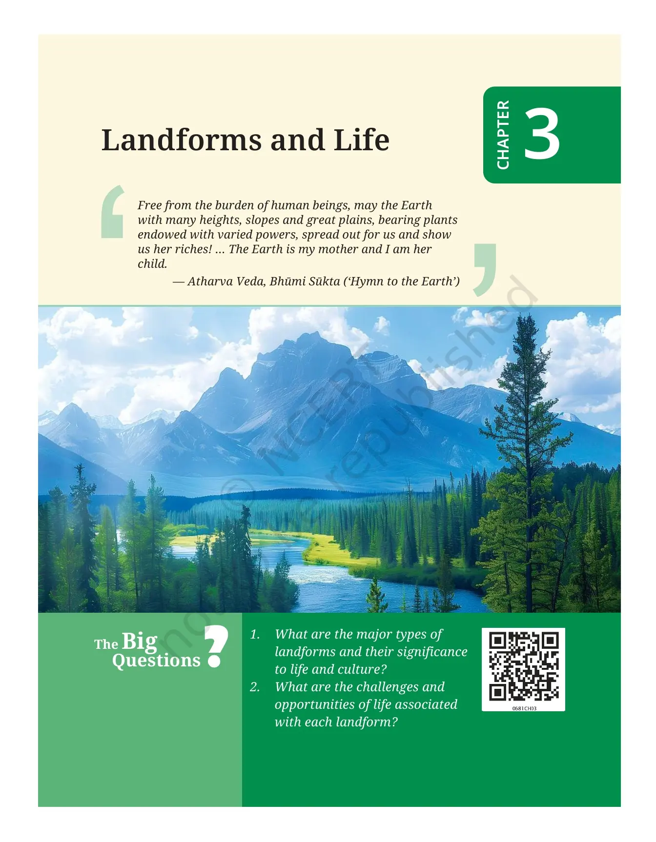
| Chapter opener | 41 | The Bhūmi Sūkta verse from the Atharva Veda and the two Big Questions on landform types and on the challenges each landform brings |
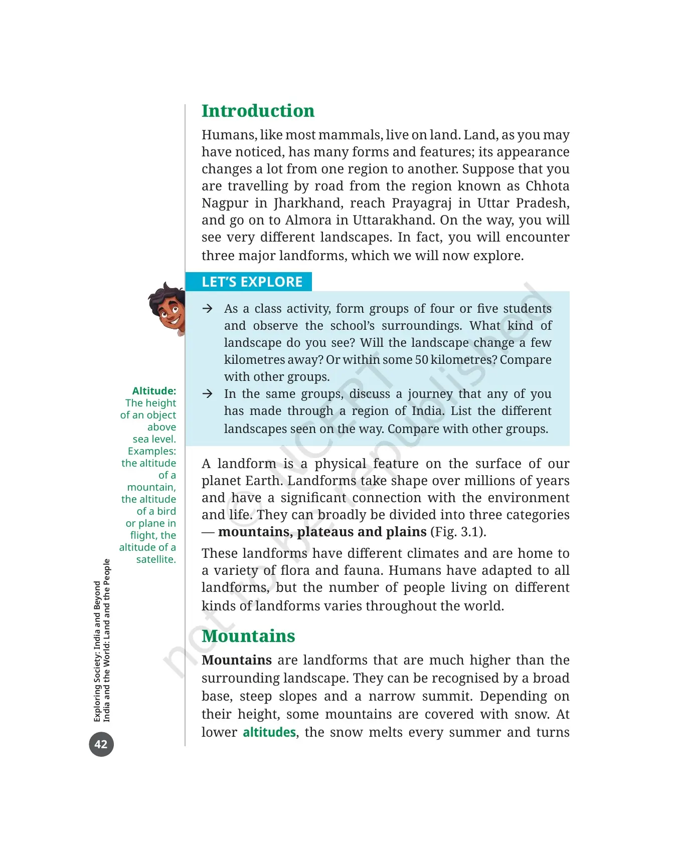
| Introduction | 42 | The road trip from Chhota Nagpur in Jharkhand to Prayagraj in Uttar Pradesh and on to Almora in Uttarakhand, the first LET'S EXPLORE box and the margin word Altitude |
| Mountains | 42 to 43 | Fig. 3.1, the definition of a mountain, how hills differ, snow and melting snow, and the THINK ABOUT IT box on what snow is |
| Six mountains of the world | 44 to 45 | Fig. 3.2 with photographs of six mountains and Fig. 3.3, the sketch that puts their relative heights on one 9,000 m scale |
| Mountain environment | 46 to 48 | Young and old mountains, montane forest and conifers, the Kālidāsa verses, Fig. 3.4 mountain animals and the box on the Ganga |
| Life in the mountains | 48 to 49 | Fig. 3.5 terrace farming, herding, tourism and pilgrimage, and the box on Bachendri Pal and Arunima Sinha |
| Challenges in the mountains | 50 | Fig. 3.6 with seven pictures of mountain challenges, plus the margin words landslide, flash flood, avalanche and cloudburst |
| Sacred mountains | 51 | The DON'T MISS OUT box on the many names of Mount Everest and on Mount Kailash |
| Plateaus | 51 to 52 | What a plateau is, the Tibetan and Deccan plateaus, mining, lava soils and Fig. 3.7, the Nohkalikai Falls |
| Plains | 53 to 54 | What a plain is, how floodplains form, Fig. 3.8 world map and Fig. 3.9, the satellite view of the Ganga plain |
| Life in the plains | 54 to 56 | Population, crops, irrigation and groundwater, sacred confluences, and Fig. 3.10 on river transport |
| Deserts and the tiṇais | 56 to 57 | Hot and cold deserts, the Thar and Gobi, and the table of the five tiṇais of Tamil Sangam poetry |
| Before we move on ... | 57 | A three-point recap of the whole chapter in the textbook's own words |
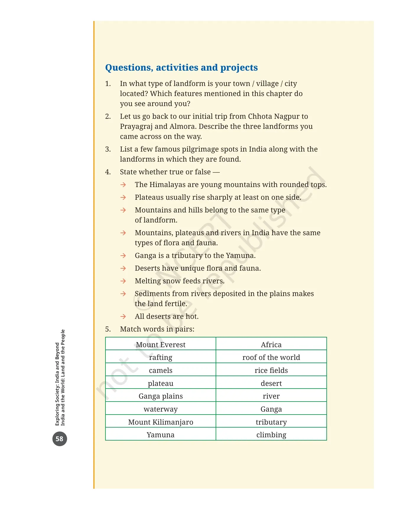
| Questions, activities and projects | 58 | 5 numbered items, including a nine-statement true or false set and an eight-pair matching question |
Also Check:
The Three Landforms This Class 6 Chapter Is Built On: Mountains, Plateaus and Plains
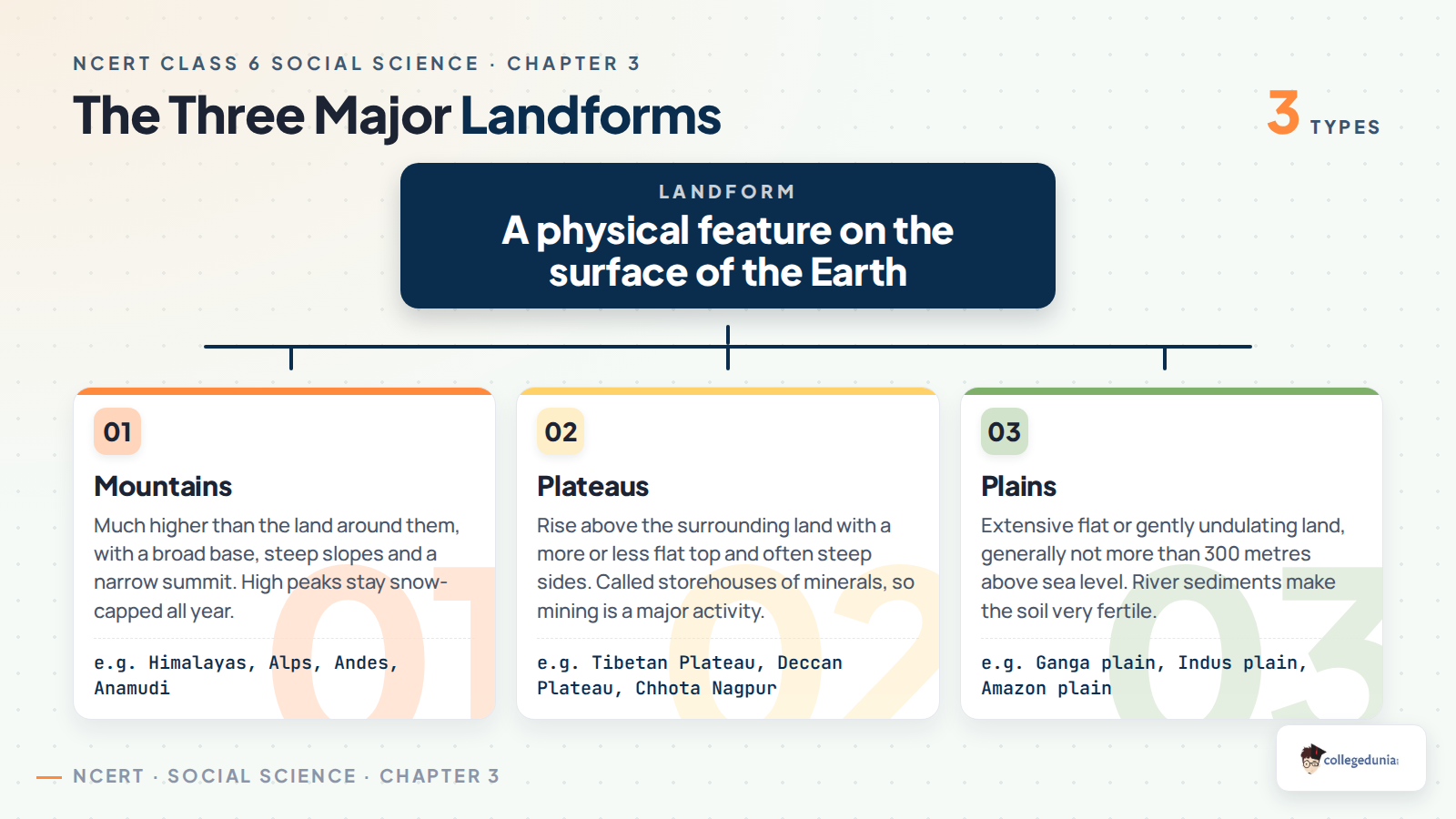
The chapter starts with a journey rather than a definition. Travel by road from Chhota Nagpur in Jharkhand to Prayagraj in Uttar Pradesh and then to Almora in Uttarakhand, and the land under you changes three times. A landform is a physical feature on the surface of the Earth, and the chapter divides landforms into three broad types: mountains, plateaus and plains.
- Landforms take shape over millions of years and are closely tied to the environment and to human life.
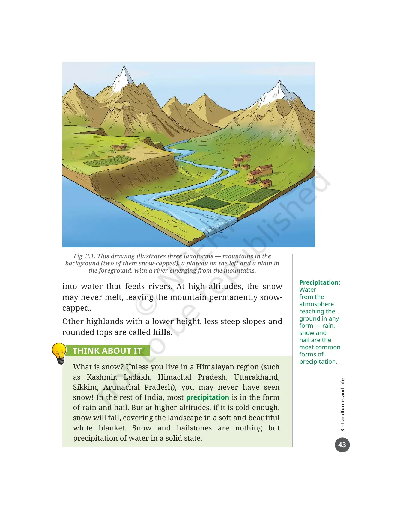
- Fig. 3.1 shows all three in one drawing: mountains at the back, two of them snow-capped, a plateau on the left and a plain in front with a river coming out of the mountains.
- Each landform has its own climate and its own flora and fauna.
- Humans have adapted to all landforms, but the number of people living on each kind varies across the world.
The margin word on this page is altitude, the height of an object above sea level. The book gives three examples: the altitude of a mountain, the altitude of a bird or a plane in flight, and the altitude of a satellite. You will need the word on almost every page that follows, so learn it first.
The first LET'S EXPLORE box turns the idea into a class activity. In groups of four or five, look at the land around your school and describe the landscape. Then ask whether it would change a few kilometres away, or within about 50 kilometres. The second half of the box asks each group to list the landscapes seen on a real journey any member has made through India, and to compare notes with the other groups.
Landforms and Life Class 6 One Shot Revision
Source: Magnet Brains on YouTube
Mountains, Hills and the Six Peaks Shown in Fig. 3.2 and Fig. 3.3
A mountain is a landform that stands much higher than the land around it. The chapter gives three features you can use to recognise one: a broad base, steep slopes and a narrow summit. Height decides how much snow it holds, and the snow decides what happens to the rivers below.
- At lower altitudes the snow melts every summer and turns into water that feeds rivers.
- At high altitudes the snow may never melt, leaving the mountain permanently snow-capped.
- Other highlands with lower height, gentler slopes and rounded tops are called hills, not mountains.
- Most mountains come in ranges such as the Himalayas in Asia, the Alps in Europe and the Andes in South America, some stretching for thousands of kilometres.
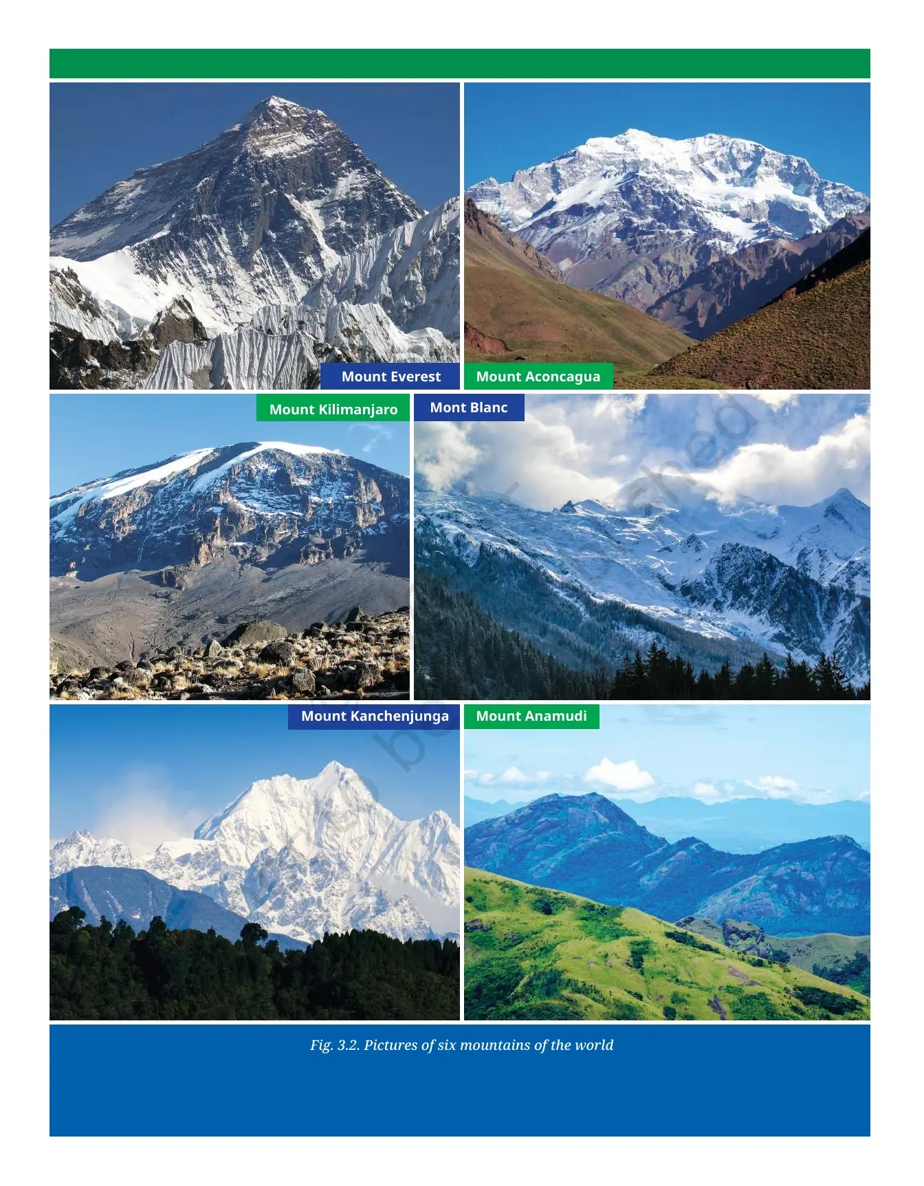
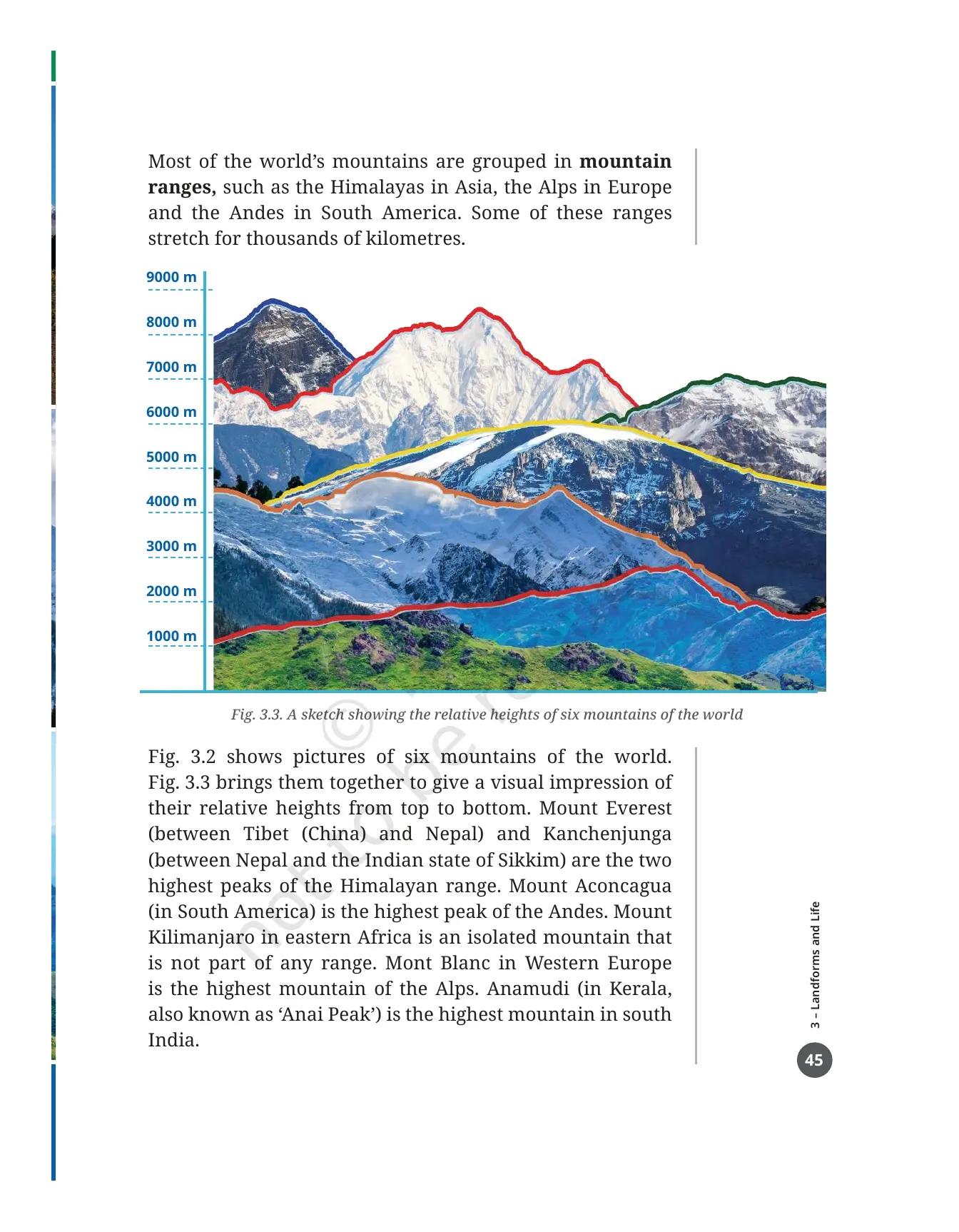
Fig. 3.2 on printed page 44 carries photographs of six mountains, and Fig. 3.3 on the next page redraws all six on a single scale that runs from 1,000 m to 9,000 m, so you can see their heights against one another. Learn the six from the table below.
| Mountain | Where it is | What the chapter says about it |
|---|---|---|
| Mount Everest | Between Tibet (China) and Nepal | One of the two highest peaks of the Himalayan range, and the highest mountain in the world at 8,848 m |
| Kanchenjunga | Between Nepal and the Indian state of Sikkim | The second of the two highest Himalayan peaks named in the chapter |
| Mount Aconcagua | South America | The highest peak of the Andes |
| Mont Blanc | Western Europe | The highest mountain of the Alps |
| Mount Kilimanjaro | Eastern Africa | An isolated mountain that is not part of any range |
| Anamudi | Kerala, also called Anai Peak | The highest mountain in south India |
The chapter then separates young mountains from old ones, and this is the fact most often turned into a test question. Mountains with tall sharp peaks, like the Himalayas, are young, while shorter rounded mountains and hills, like the Aravalli Range, are much older and have been rounded by erosion. Young here still means millions of years ago.
One more line is worth underlining. In the Himalayas, upliftment and erosion both continue to this day, which is why some mountains of the world are still growing in height. The THINK ABOUT IT box on printed page 43 sits alongside this and explains snow: in most of India precipitation falls as rain or hail, but high and cold enough, it falls as snow, which is simply water in a solid state.
The Mountain Environment: Montane Forests, Conifers and the Animals in Fig. 3.4
Mountain slopes carry a forest type of their own. Montane forest is the margin word for it, and the trees that fill it are conifers such as pines, firs, spruce and deodar. They grow tall and cone-shaped with thin pointed leaves, a shape that suits cold slopes and heavy snow.
- Above the tree line the conifers give way to grasses, mosses and lichen.
- Moss is a small green plant without flowers or true roots that spreads in a cushion-like cover.
- Lichen is a plant-like organism that clings to rocks, walls or trees.
- Deep forests, rivers, lakes, grasslands and caves make the mountains home to a wide range of animals.
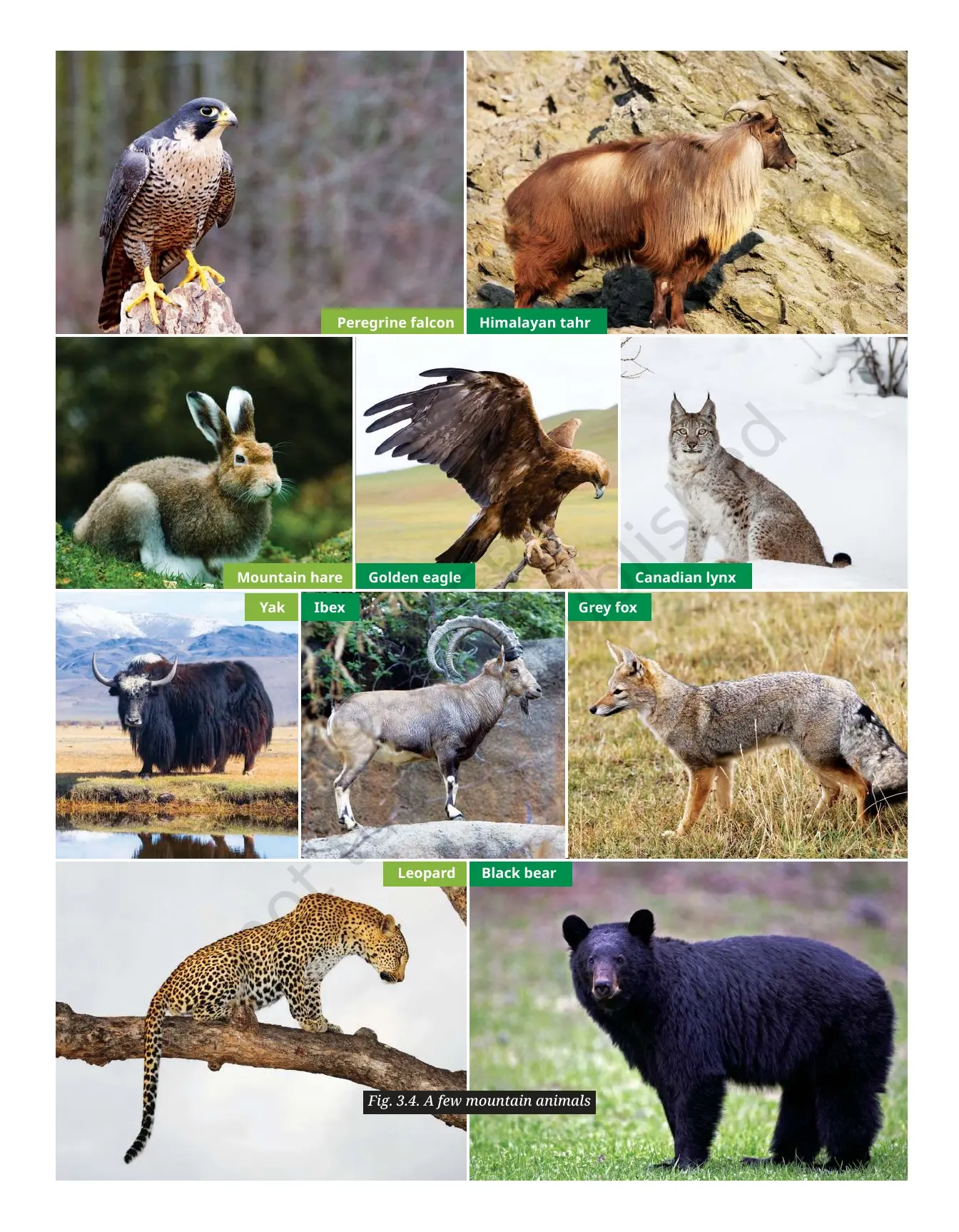
Fig. 3.4 on printed page 47 puts faces to that last point. The animals shown are the golden eagle, the peregrine falcon, the Canadian lynx, the leopard, the ibex, the Himalayan tahr, the mountain hare, the yak, the grey fox and the black bear, and the text alongside adds the snow leopard. Learning this list is the quickest way to answer a one-mark question on mountain fauna.
Two boxes sit on these pages and both are worth reading properly. The first carries two verses from Kumārasambhava, a long poem by Kālidāsa, who lived at least 1,500 years ago and is often called the greatest poet of ancient India. The poem opens with an invocation to the Himalayas as the Lord of mountains, stretching from the western to the eastern oceans.
The discussion questions with the verses ask you to name those two oceans, locate them and the Lord of mountains on Fig. 5.2, and work out why the Gangā is mentioned. The second box is the DON'T MISS OUT on the Ganga itself. The Ganga is the largest river originating from the Himalayas and runs nearly 2,500 km, with tributaries such as the Yamuna and the Ghagara that also rise in the Himalayas. The Son, or Sone, is the exception: it comes from the Vindhya Range to the south of the Ganga plain.
Life in the Mountains: Terrace Farming, Herding, Tourism and Pilgrimage
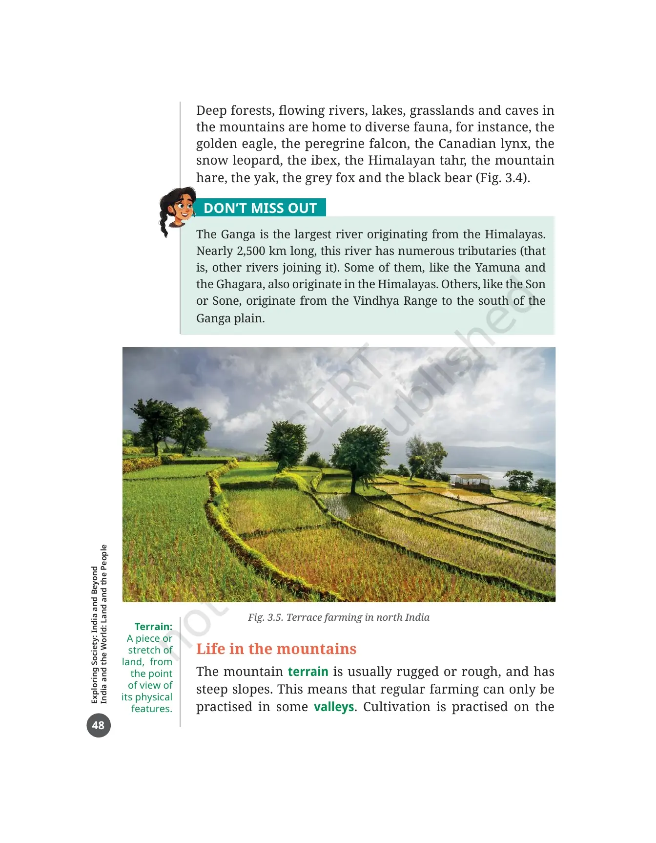
Mountain terrain is rugged and steeply sloped, so ordinary farming is possible only in some valleys. The chapter's answer to that problem is the one picture students remember. Fig. 3.5 shows terrace farming in north India, where steps are cut into the slope so crops can be grown on it.
- Farming is limited to valleys, because the terrain, the physical stretch of land, is rough and steep.
- Terrace farming makes the slopes usable by cutting them into steps.
- In many mountain regions of the world, herding is preferred over agriculture.
- Tourism is often an important source of income, drawn by crisp air and scenery.
- Tourists also come for skiing, hiking, mountaineering and paragliding, and pilgrims have travelled to holy sites in these uplands for centuries.
The section ends with a warning rather than a sales pitch. Too many visitors put the fragile mountain environment under pressure, and the chapter says plainly that the right balance is often hard to find. That single sentence answers any question asking whether mountain tourism is good or bad.
The DON'T MISS OUT box on printed page 49 carries two mountaineers. Bachendri Pal started climbing young, led many women's climbing expeditions, became the first Indian woman to climb Mount Everest and was awarded the Padma Shri the same year, and the Padma Bhushan later. Arunima Sinha lost a leg in an accident at the age of 22, trained with Bachendri Pal's encouragement, climbed Everest, went on to climb the highest peak of every continent including Mount Vinson in Antarctica, and was awarded the Padma Shri.
Seven Challenges of Mountain Life Shown in Fig. 3.6 and the Margin Words That Explain Them
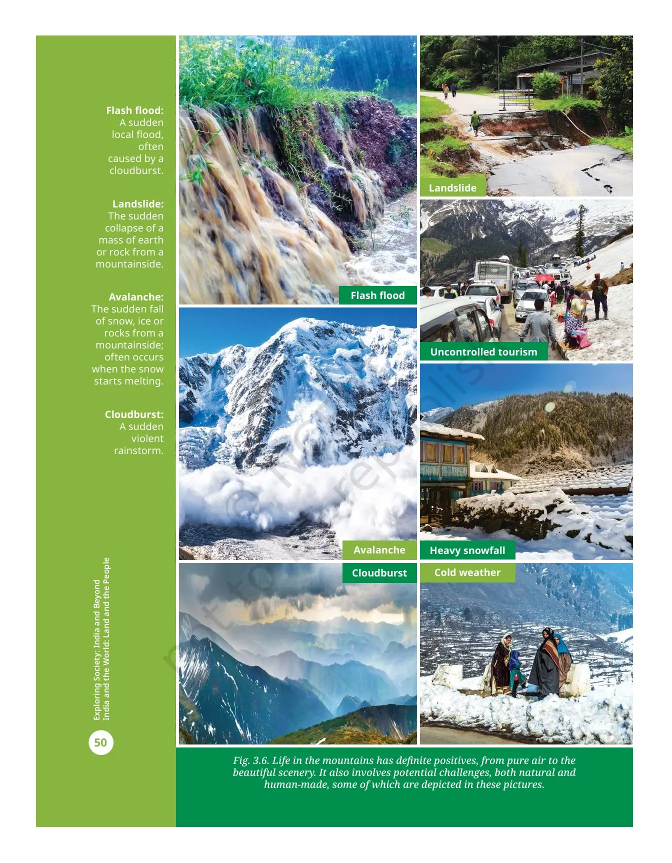
Printed page 50 is a full picture spread. The LET'S EXPLORE box before it asks groups to discuss each picture and write one paragraph on each, and then to discuss why people still choose to live in the mountains despite all of this. Four of the seven have their own margin definitions.
| Challenge in Fig. 3.6 | Natural or human-made | What the book says |
|---|---|---|
| Landslide | Natural | The sudden collapse of a mass of earth or rock from a mountainside |
| Flash flood | Natural | A sudden local flood, often caused by a cloudburst |
| Avalanche | Natural | The sudden fall of snow, ice or rocks from a mountainside, often when the snow starts melting |
| Cloudburst | Natural | A sudden violent rainstorm |
| Heavy snowfall | Natural | Shown as a picture, with no separate margin definition |
| Cold weather | Natural | Shown as a picture, with no separate margin definition |
| Uncontrolled tourism | Human-made | The only human-made challenge in the set, and the one linked to the tourism section before it |
The caption under Fig. 3.6 is balanced, and copying it into your notebook is a good idea. It says mountain life has definite positives, from pure air to beautiful scenery, and also potential challenges, both natural and human-made. A question asking for both sides of mountain life is answered by that caption alone.
The last box in the mountains section is about belief. Many traditional communities treat mountains as sacred. Tibetans call Mount Everest Chomolungma, meaning Mother Goddess of the World, and Nepalis call it Sagarmatha, meaning Goddess of the Sky. Mount Kailash in Tibet is held sacred by followers of Hinduism, Buddhism, Jainism and Bon, an ancient Tibetan religion.
Plateaus: Storehouses of Minerals, Lava Soils and the Waterfalls They Carry
A plateau rises above the land around it and has a more or less flat surface, with some sides often falling away in steep slopes. Like mountains, plateaus can be young or old. Their height ranges from a few hundred metres to several thousand metres.
- The Tibetan Plateau is the largest and highest plateau in the world, with an average altitude of 4,500 m, which earned it the nickname Roof of the World.
- From east to west the Tibetan Plateau runs nearly 2,500 km, the same as the distance from Chandigarh to Kanyakumari.
- The Deccan Plateau of central and south India is one of the oldest plateaus in the world, formed through volcanic activity millions of years ago.
- Plateaus are rich in mineral deposits and are called storehouses of minerals, which is why mining is a major activity on them.
The mining examples are easy marks. The East African Plateau is famous for gold and diamond mining. In India, huge reserves of iron, coal and manganese are found in the Chhota Nagpur Plateau, the same region the chapter's opening road trip begins in.
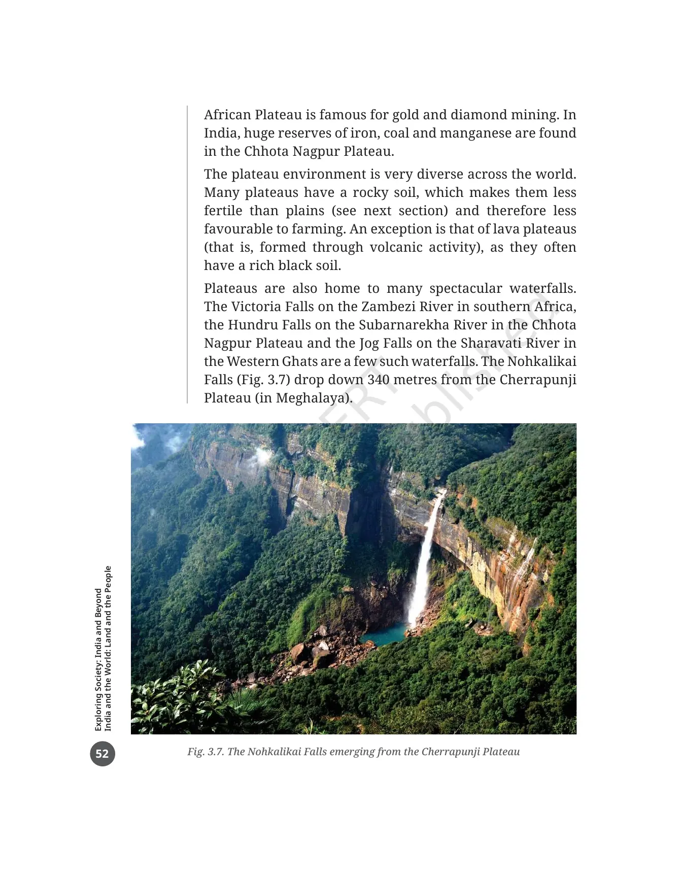
Soil is where plateaus lose to plains. Many plateaus have rocky soil, which makes them less fertile and less suited to farming. The exception is a lava plateau, formed through volcanic activity, which often has rich black soil. The other thing plateaus are good at is dropping water from a height, and the chapter names four waterfalls.
| Waterfall | River | Where it is |
|---|---|---|
| Victoria Falls | Zambezi | Southern Africa |
| Hundru Falls | Subarnarekha | Chhota Nagpur Plateau |
| Jog Falls | Sharavati | Western Ghats |
| Nohkalikai Falls | Shown in Fig. 3.7 | Drops 340 metres from the Cherrapunji Plateau in Meghalaya |
Plains, Floodplains and Why 40 Crore People Live in India's Ganga Plain
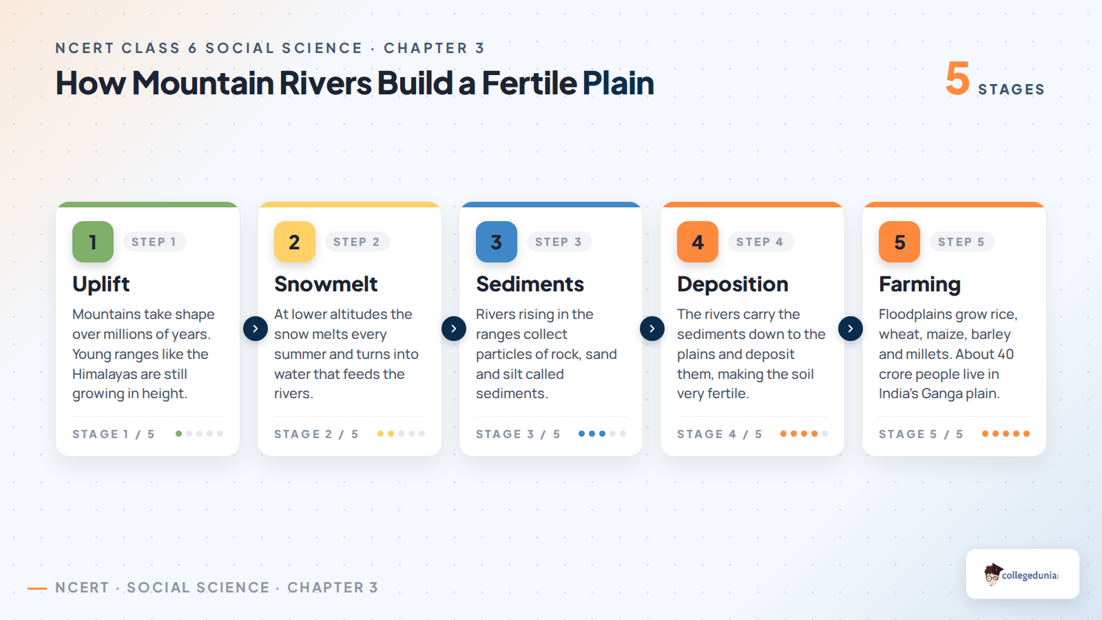
Plains have an extensive flat or gently undulating surface with no large hills and no deep valleys. The number to remember is in the definition itself. Plains are generally not more than 300 metres above sea level, where sea level means the average level of the surface of the oceans.
- Floodplains are one type of plain, formed by rivers that rise in mountain ranges.
- Those rivers collect particles of rock, sand and silt called sediments.
- The sediments are carried down and deposited in the plains, which makes the soil very fertile.
- That fertility makes plains ideal for growing crops of all kinds, so agriculture is the major economic activity here.
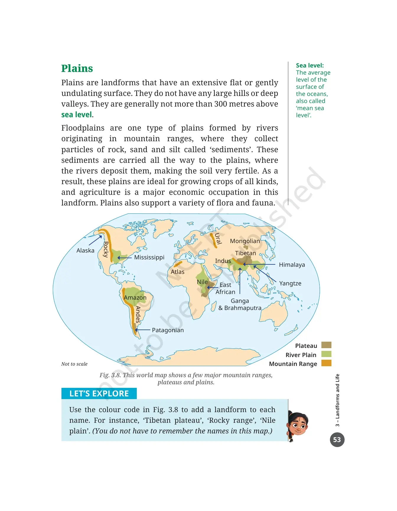
Two figures teach this section. Fig. 3.8 is a world map that colour-codes major mountain ranges, plateaus and river plains, naming the Ural, Rocky, Andes, Atlas and Himalaya among ranges, the Tibetan, Mongolian, Patagonian and East African among plateaus, and the Mississippi, Nile, Amazon, Indus, Yangtze and Ganga and Brahmaputra among plains. The LET'S EXPLORE box asks you to attach the right landform word to each name, as in Tibetan plateau, Rocky range and Nile plain.
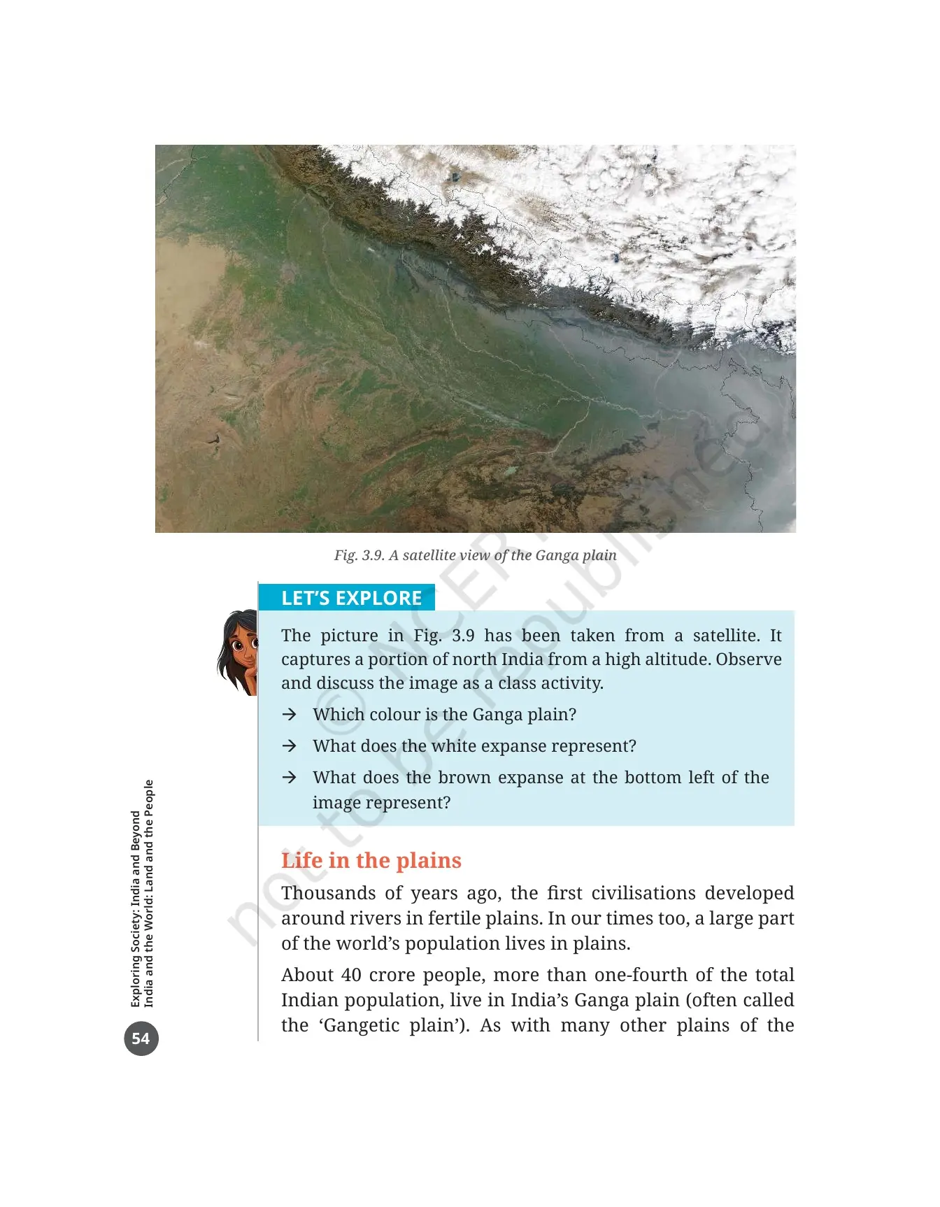
Fig. 3.9 is a satellite view of the Ganga plain taken from high altitude. Its activity box asks three questions: which colour is the Ganga plain, what the white expanse represents, and what the brown expanse at the bottom left represents. Answer these with the map in front of you, not from memory.
Then come the figures that make this the most crowded landform on Earth. About 40 crore people, more than one-fourth of India's total population, live in the Ganga plain, often called the Gangetic plain. The first civilisations of the world also grew around rivers in fertile plains like this one.
| What the chapter lists | Details from the Ganga plain section |
|---|---|
| Main occupations | River fishing and agriculture |
| Food crops | Rice, wheat, maize, barley and millets |
| Fibre crops | Cotton, jute and hemp |
| Older way of watering fields | Rainfed farming, watered through rainfall alone |
| Newer way of watering fields | Irrigation through canal networks or water pumped from the ground |
| Problems named | Depletion of groundwater, high population and pollution |
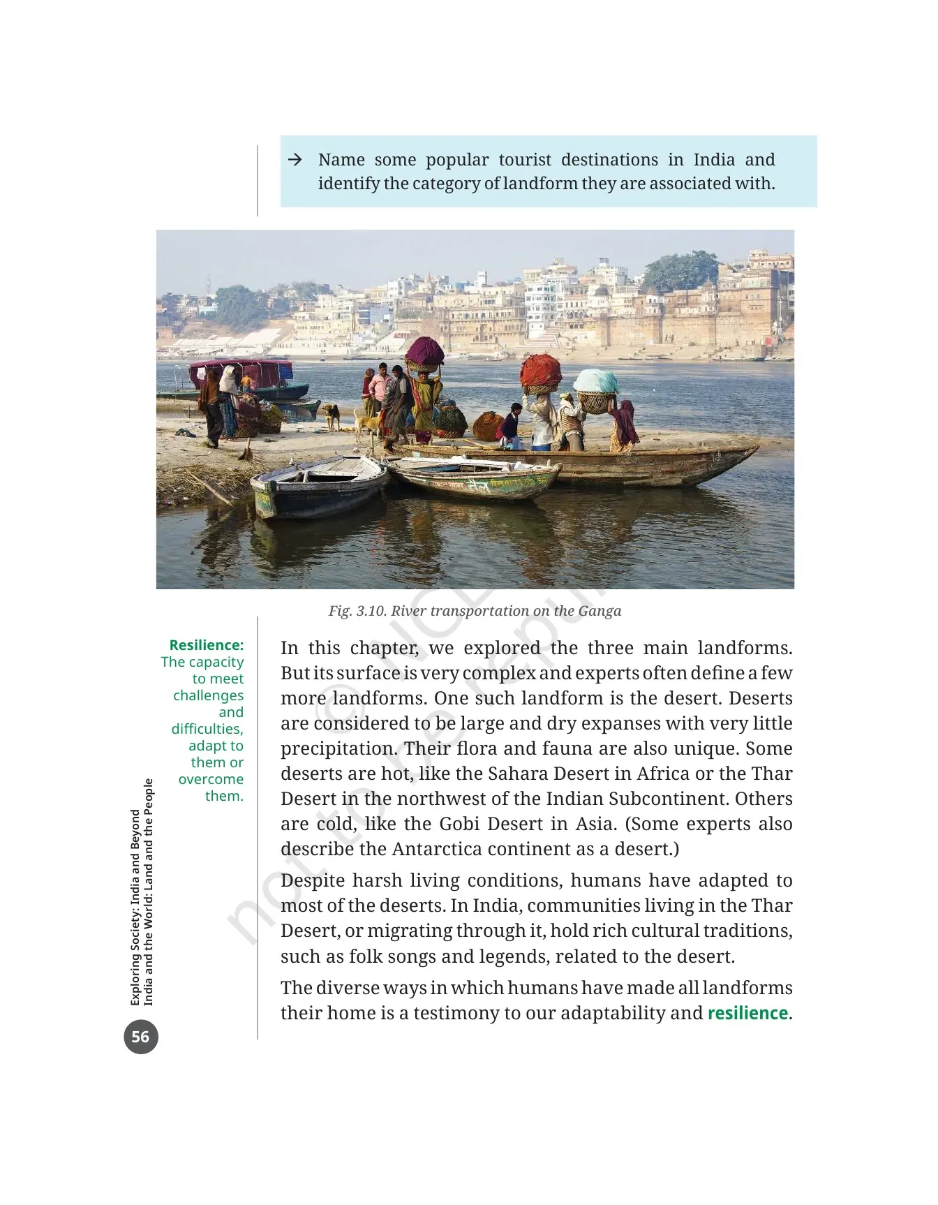
The section closes on culture and transport. Communities across the world have treated a river's source and its confluence, the meeting point of two or more rivers, as sacred, and India holds many festivals and rituals at such places. Because plains slope gently, river navigation is easy, and Fig. 3.10 shows people still using boats to move along stretches of the Ganga.
Deserts and the Five Tiṇais of Tamil Sangam Poetry
After the three main landforms, the chapter admits that the Earth's surface is more complex than any three-way split. Experts define a few more landforms, and the one it picks is the desert. Deserts are large, dry expanses with very little precipitation and a flora and fauna of their own.
- Hot deserts named in the chapter: the Sahara in Africa and the Thar in the northwest of the Indian Subcontinent.
- Cold deserts named in the chapter: the Gobi in Asia. Some experts also describe Antarctica as a desert.
- Humans have adapted to most deserts despite harsh living conditions.
- Communities living in or migrating through the Thar Desert hold rich cultural traditions such as folk songs and legends tied to the desert.
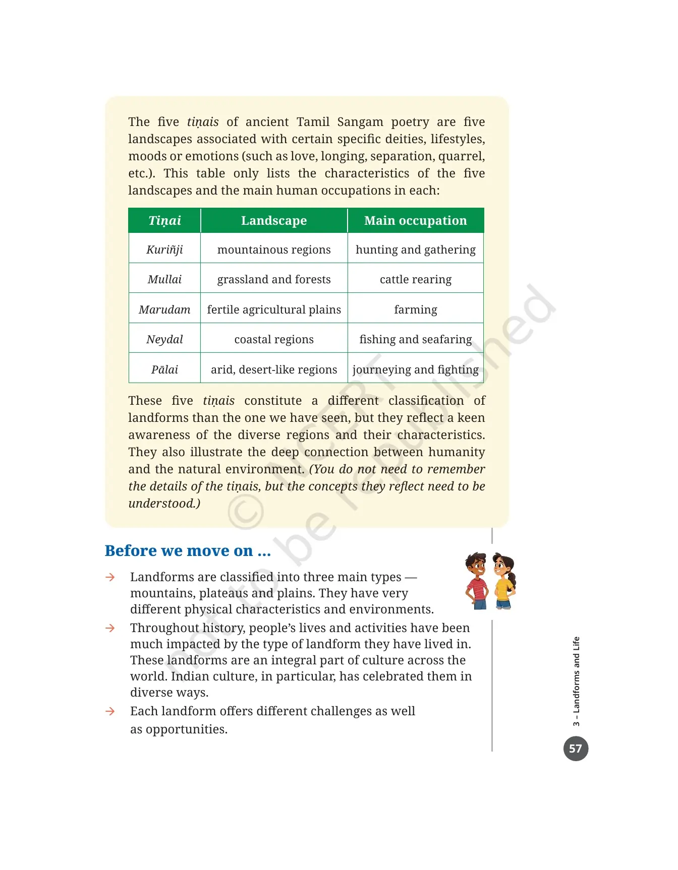
The last box in the chapter offers a completely different way of sorting land. Ancient Tamil Sangam poetry used five tiṇais, five landscapes each linked to particular deities, lifestyles and moods such as love, longing, separation and quarrel. The table in the book lists only the landscape and the main occupation of each.
| Tiṇai | Landscape | Main occupation |
|---|---|---|
| Kuriñji | Mountainous regions | Hunting and gathering |
| Mullai | Grassland and forests | Cattle rearing |
| Marudam | Fertile agricultural plains | Farming |
| Neydal | Coastal regions | Fishing and seafaring |
| Pālai | Arid, desert-like regions | Journeying and fighting |
The book is clear about what you must take from this table. You do not need to remember the five names, but you do need the idea behind them. The tiṇais are a different classification of landforms from the one the chapter uses, and they show a keen awareness of diverse regions and a deep connection between people and their natural surroundings.
Every Figure, Activity Box and Margin Word Inside the Landforms and Life PDF
This chapter teaches through pictures and margin words as much as through paragraphs. Ten numbered figures do the visual work, twelve boxes turn the reading into tasks, and fourteen margin words supply the vocabulary. Tick them off as you go.
| Figure or box | Printed page | What it shows or asks |
|---|---|---|
| Fig. 3.1 | 43 | A drawing of all three landforms together: mountains behind, a plateau on the left and a plain in front with a river |
| Fig. 3.2 | 44 | Photographs of six mountains of the world |
| Fig. 3.3 | 45 | A sketch placing the same six mountains on one scale from 1,000 m to 9,000 m |
| Fig. 3.4 | 47 | Ten mountain animals, from the peregrine falcon and the yak to the black bear |
| Fig. 3.5 | 48 | Terrace farming in north India |
| Fig. 3.6 | 50 | Seven pictures of mountain challenges, natural and human-made |
| Fig. 3.7 | 52 | The Nohkalikai Falls emerging from the Cherrapunji Plateau |
| Fig. 3.8 | 53 | A world map colour-coding major mountain ranges, plateaus and river plains |
| Fig. 3.9 | 54 | A satellite view of the Ganga plain |
| Fig. 3.10 | 56 | River transportation on the Ganga |
| LET'S EXPLORE boxes | 42, 49, 53, 54, 55 | Observe the school's surroundings, discuss Fig. 3.6, label Fig. 3.8, read Fig. 3.9, and find sacred river sources plus tourist spots by landform |
| THINK ABOUT IT | 43 | What snow is, and why most of India sees rain and hail instead |
| DON'T MISS OUT boxes | 48, 49, 51, 51 | The Ganga and its tributaries, Bachendri Pal and Arunima Sinha, sacred mountains, and the Tibetan and Deccan plateaus |
| Kālidāsa box | 46 | Two verses from Kumārasambhava with two discussion questions |
| Tiṇai box | 57 | The five landscapes of Tamil Sangam poetry and their main occupations |
| Margin words | 42 to 56 | Altitude, precipitation, montane forest, moss, lichen, terrain, valley, flash flood, landslide, avalanche, cloudburst, sea level, confluence and resilience |
Questions, Activities and Projects at the End of the Landforms and Life Chapter
Printed page 57 gives a three-point recap called "Before we move on ...", covering the three landform types, the way landforms shape culture, and the challenges and opportunities each one brings. Then come 5 numbered items on printed page 58, and the school test is usually built straight out of them.
- Your own landform. Name the landform your town, village or city sits in, and list the features from the chapter that you can see around you.
- The opening trip. Go back to the journey from Chhota Nagpur to Prayagraj to Almora and describe the three landforms met on the way.
- Pilgrimage spots. List a few famous pilgrimage spots in India along with the landforms they are found in.
- True or false. Nine statements, covering the Himalayas, plateau slopes, hills, flora and fauna, the Ganga and the Yamuna, deserts, melting snow and river sediments.
- Match words in pairs. Eight pairs to join, including Mount Everest, rafting, camels, plateau, Ganga plains, waterway, Mount Kilimanjaro and the Yamuna.
Question 4 is where most marks are lost, because several statements are deliberately written the wrong way round. Read each one twice before you answer. Question 5 is easier: match Mount Everest with climbing, Mount Kilimanjaro with Africa, plateau with roof of the world, camels with desert, Ganga plains with rice fields, waterway with river, rafting with Ganga and Yamuna with tributary.
Common Mistakes Students Make in the Landforms and Life Chapter
- Calling the Himalayas old and rounded. The Himalayas are young with tall sharp peaks. The Aravalli Range is the old, rounded one.
- Treating hills and mountains as one landform. Hills are lower, with gentler slopes and rounded tops.
- Saying plateaus are the most fertile landform. Most plateaus have rocky soil. Only lava plateaus carry rich black soil.
- Writing that the Ganga is a tributary of the Yamuna. It is the other way round: the Yamuna joins the Ganga.
- Assuming every desert is hot. The Gobi is a cold desert, and some experts count Antarctica as one too.
Related Links:
How to Read the Class 6 Landforms and Life PDF in One 45-Minute Sitting
This chapter is longer than the first two and carries more pictures, so plan one sitting with the PDF open, an atlas nearby and a pencil. Follow the order below and you will finish the reading, the figures and the activity boxes together.
- Minutes 0 to 5: read the Bhūmi Sūkta verse and the two Big Questions on printed page 41. They tell you what to look for.
- Minutes 5 to 20: read printed pages 42 to 47 and copy the six mountains from Fig. 3.2 and Fig. 3.3 into your notebook.
- Minutes 20 to 30: read the mountain life pages and list the seven challenges from Fig. 3.6 with their margin definitions.
- Minutes 30 to 40: read the plateau and plain sections and label the names on Fig. 3.8 with the right landform word.
- Minutes 40 to 45: read the desert pages, the tiṇais table and the "Before we move on ..." recap.
Come back the next day for questions 4 and 5, because the true or false set needs a second reading to catch the reversed statements. That second pass is what turns a chapter you have read into a chapter you can answer, and it is why students who keep the official PDF on their phone finish this theme faster than students working from guide books alone.
More Landforms and Life Class 6 Resources
The book PDF gives you the printed chapter. These pages give you the answers, the revision layer and the last-day recap for the same chapter.
| Resource | What it gives you |
|---|---|
| Landforms and Life Class 6 NCERT Solutions | Step-by-step answers to all 5 questions, activities and projects, including every true or false statement and all eight matching pairs |
| Landforms and Life Class 6 Revision Notes | The three landforms, the six mountains, the plateau minerals and the Ganga plain figures in one short read |
| Landforms and Life Class 6 Handwritten Notes | A topper's handwritten pages with hand-drawn landform sketches and colour-coded sub-headings for a last-day recap |
| Landforms and Life Class 6 NCERT Book PDF | This page. The official 2026-27 chapter file, printed pages 41 to 58 of Exploring Society: India and Beyond |
NCERT Book PDF for Class 6 Social Science: All 14 Chapters
Exploring Society: India and Beyond runs to 14 chapters across five themes. Download the ones your school has taught, or take the full set in one go.
| Chapter | Resource |
|---|---|
| Chapter 1 | Locating Places on the Earth NCERT Book PDF |
| Chapter 2 | Oceans and Continents NCERT Book PDF |
| Chapter 3 | Landforms and Life NCERT Book PDF (this page) |
| Chapter 4 | Timeline and Sources of History NCERT Book PDF |
| Chapter 5 | India, That Is Bharat NCERT Book PDF |
| Chapter 6 | The Beginnings of Indian Civilisation NCERT Book PDF |
| Chapter 7 | India's Cultural Roots NCERT Book PDF |
| Chapter 8 | Unity in Diversity, or 'Many in the One' NCERT Book PDF |
| Chapter 9 | Family and Community NCERT Book PDF |
| Chapter 10 | Grassroots Democracy Part 1: Governance NCERT Book PDF |
| Chapter 11 | Grassroots Democracy Part 2: Local Government in Rural Areas NCERT Book PDF |
| Chapter 12 | Grassroots Democracy Part 3: Local Government in Urban Areas NCERT Book PDF |
| Chapter 13 | The Value of Work NCERT Book PDF |
| Chapter 14 | Economic Activities Around Us NCERT Book PDF |
Landforms and Life Class 6 Social Science NCERT Book PDF FAQs
Common Questions on the Class 6 Social Science Chapter 3 File
Ques. Where can I download the NCERT Class 6 Social Science Chapter 3 Landforms and Life PDF?
Ans. You can download it directly from this page. It is the official NCERT chapter file for the 2026-27 print of Exploring Society: India and Beyond, and it is free.
Ques. How many pages is the Landforms and Life chapter PDF?
Ans. The file runs to 18 pages. It covers printed pages 41 to 58 of the textbook, from the Bhūmi Sūkta verse on the opening page to the matching-pairs question on the last page.
Ques. What is a landform?
Ans. A landform is a physical feature on the surface of the Earth. Landforms take shape over millions of years and are closely connected to the environment and to human life.
Ques. What are the three main types of landforms in the Class 6 chapter?
Ans. Mountains, plateaus and plains. Fig. 3.1 shows all three in a single drawing, with mountains in the background, a plateau on the left and a plain in front. The chapter later adds the desert as a fourth landform that experts often define separately.
Ques. How is a plateau defined in the chapter?
Ans. A plateau is a landform that rises above the surrounding land and has a more or less flat surface, with some sides often falling away in steep slopes. Plateau heights range from a few hundred metres to several thousand metres.
Ques. What is the difference between a mountain and a hill?
Ans. A mountain stands much higher than the land around it and has a broad base, steep slopes and a narrow summit. A hill is a highland of lower height, with less steep slopes and a rounded top.
Ques. Which six mountains are shown in Fig. 3.2 and Fig. 3.3?
Ans. Mount Everest, Kanchenjunga, Mount Aconcagua, Mont Blanc, Mount Kilimanjaro and Anamudi. Everest and Kanchenjunga are the two highest peaks of the Himalayan range, Aconcagua is the highest peak of the Andes, Mont Blanc is the highest mountain of the Alps, Kilimanjaro is an isolated mountain in eastern Africa, and Anamudi in Kerala is the highest mountain in south India.
Ques. Why are plateaus called storehouses of minerals?
Ans. Plateaus are rich in mineral deposits, so many of the world's largest mines are found on them. The East African Plateau is known for gold and diamond mining, and the Chhota Nagpur Plateau in India holds huge reserves of iron, coal and manganese.
Ques. How many people live in India's Ganga plain?
Ans. About 40 crore people, which is more than one-fourth of India's total population. The main occupations there are river fishing and agriculture, with rice, wheat, maize, barley and millets as food crops and cotton, jute and hemp as fibre crops.
Ques. What is terrace farming and why is it used in the mountains?
Ans. Terrace farming means cutting steps into a slope so crops can be grown on it. Mountain terrain is rugged with steep slopes, so ordinary farming is possible only in some valleys, and Fig. 3.5 shows terrace farming in north India as the way around that problem.
Ques. What are the five tiṇais of Tamil Sangam poetry?
Ans. Kuriñji for mountainous regions with hunting and gathering, Mullai for grassland and forests with cattle rearing, Marudam for fertile agricultural plains with farming, Neydal for coastal regions with fishing and seafaring, and Pālai for arid, desert-like regions with journeying and fighting. The book says you need the idea behind them rather than the names themselves.
Ques. How many questions are there at the end of the Landforms and Life chapter?
Ans. There are 5 numbered items under "Questions, activities and projects" on printed page 58. They ask about your own landform, the opening road trip, famous pilgrimage spots and their landforms, a nine-statement true or false set, and an eight-pair matching question.
Ques. Do I need the NCERT Solutions if I already have the book PDF?
Ans. The book PDF carries the questions but not the answers. Use the Landforms and Life Class 6 NCERT Solutions to check your true or false answers, your matching pairs and every activity box.



Comments