




Inside the NCERT Class 6 Social Science Chapter 6 The Beginnings of Indian Civilisation PDF you will find the seven characteristics of a civilisation, the town-planning of Harappa, Mohenjo-daro and Dholavira, the brisk trade in carnelian beads and shell bangles, and the two reasons the cities were abandoned around 1900 BCE. This is the full printed chapter from Exploring Society: India and Beyond for the 2026-27 session, with nothing shortened or reworded.
- 20-page official file: Chapter 6 runs from printed page 85 to printed page 104 of the Class 6 textbook.
- Covers the Indus, Harappan, Indus-Sarasvatī or Sindhu-Sarasvatī civilisation, dated in the book from about 2600 to 1900 BCE.
- Carries 15 numbered figures, 7 LET'S EXPLORE boxes, 5 THINK ABOUT IT boxes, 2 DON'T MISS OUT boxes and 8 end questions.
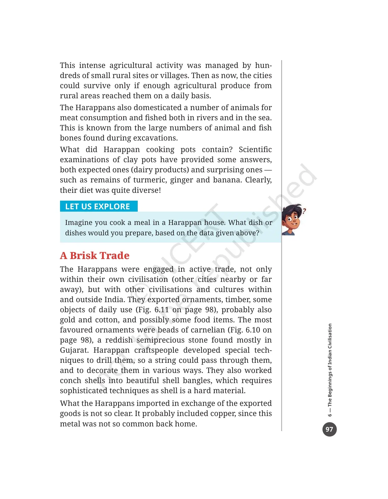
This is the unedited NCERT chapter file for the 2026-27 print run, checked page by page against the official Exploring Society: India and Beyond release before it was put on this page.
Student Feedback
What 16,410 students told us about The Beginnings of Indian Civilisation chapter, in a Collegedunia poll taken during the 2026-27 session.
- 71% of students said the list of seven characteristics of a civilisation on printed page 86 was the part they lost marks on.
- Most-mixed-up pair: the Great Bath at Mohenjo-daro and the dockyard at Lothal, swapped by about 4 in 10 students.
- Students reported that writing the city and modern-state pairs once on a rough sheet fixed Dholavira, Kalibangan and Rakhigarhi faster than re-reading the map.
Source: 2026-27 Class 6 Social Science student poll. Sample of 16,410 students from CBSE schools across 21 states.
What the Beginnings of Indian Civilisation Class 6 PDF Contains, Page by Page
The file is the printed chapter in full, not a summary sheet. It opens with a passage from the archaeologist B.B. Lal on how well balanced Harappan society was, and closes with the eight end questions on printed page 104. Use the table below to jump straight to the part you need.
| Section in the PDF | Printed pages | What is on these pages |
|---|---|---|
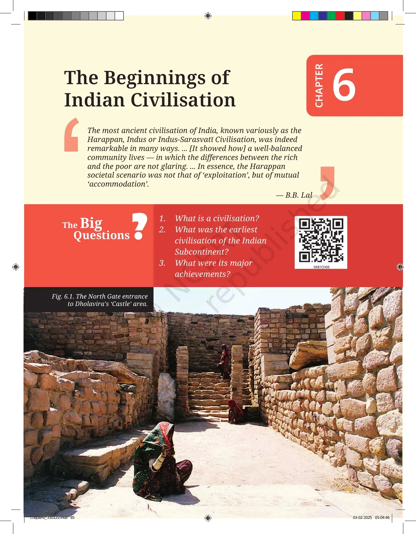
| Chapter opener | 85 | The B.B. Lal passage, Fig. 6.1 of the North Gate entrance to Dholavira's 'Castle' area, and the three Big Questions |
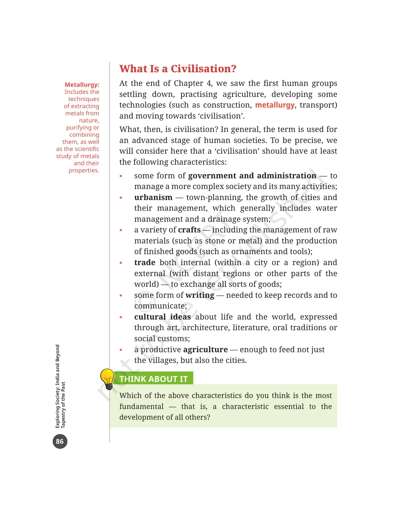
| What Is a Civilisation? | 86 and 87 | The seven characteristics of a civilisation, the margin word Metallurgy, a THINK ABOUT IT box and a LET'S EXPLORE box on professions |
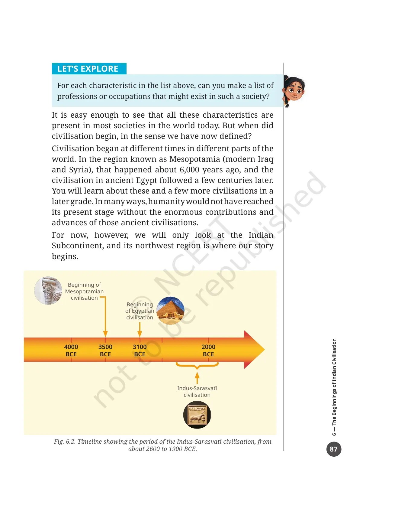
| Fig. 6.2, the timeline | 87 | Mesopotamia and Egypt set beside the Indus-Sarasvatī civilisation, dated from about 2600 to 1900 BCE |
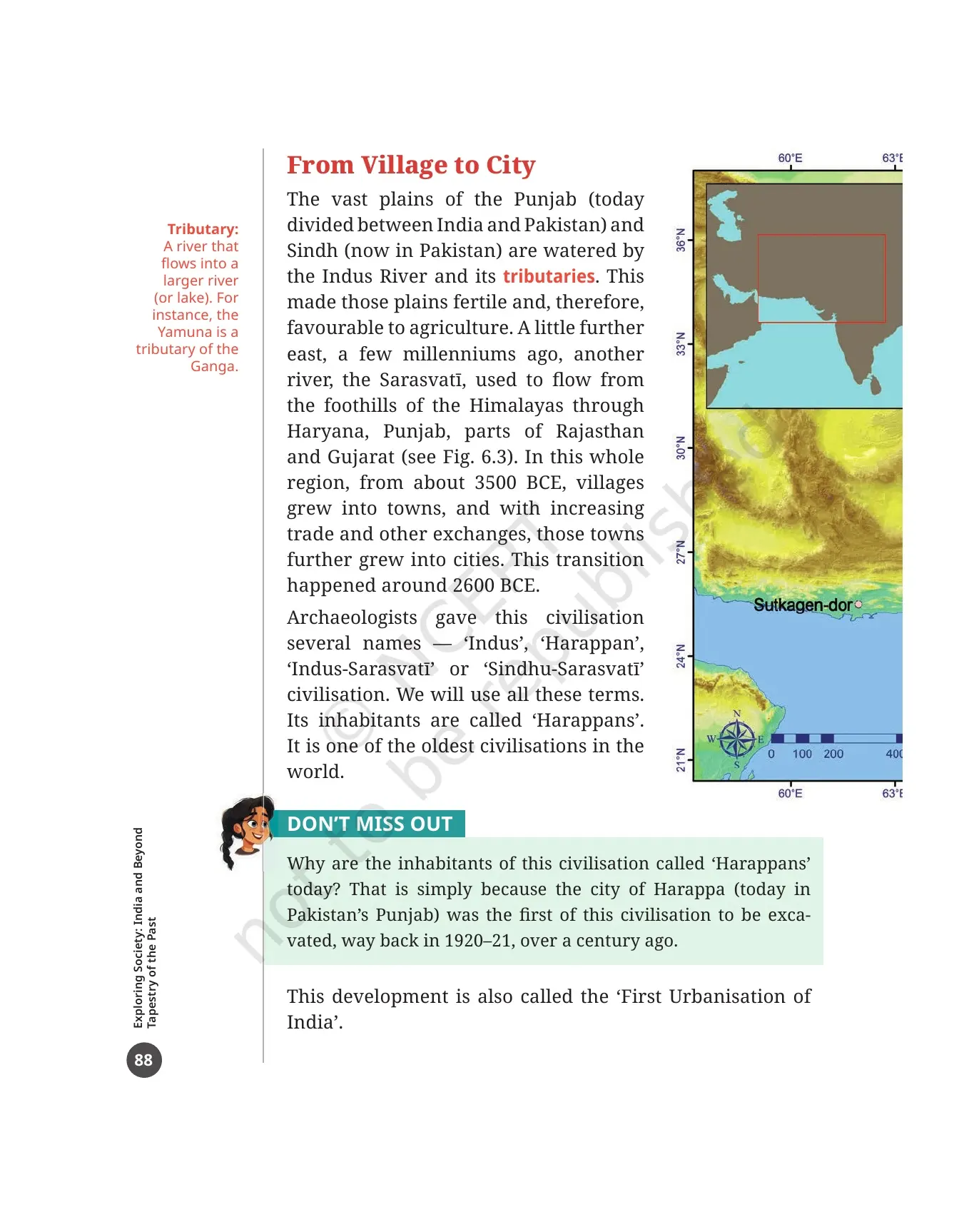
| From Village to City | 88 | The Indus and its tributaries, the Sarasvatī, the four names of the civilisation, the margin word Tributary and the DON'T MISS OUT box on Harappa |
| Fig. 6.3, the settlements map | 89 | A full-page map of the main Harappan settlements, with the mountain ranges shown in brown |
| The Sarasvatī River | 90 | The city and modern-state matching table, the Ghaggar-Hakra name, and the Ṛig Veda mention of the river |
| Town-Planning | 90 and 91 | Harappa and Mohenjo-daro in 1924, the later cities, the upper and lower towns, and the Great Bath |
| Figs. 6.4 and 6.5 | 92 | A wide street at Kalibangan and the housing area at Dholavira with its perpendicular streets |
| The Great Bath | 93 | Fig. 6.6, the three possible interpretations, and the LET'S EXPLORE debate task |
| Water Management | 94 and 95 | House drains, Fig. 6.7 at Lothal, the wells of Mohenjo-daro, the reservoirs of Dholavira and the margin word Reservoir |
| What Did the Harappans Eat? | 96 and 97 | Cereals, pulses, cotton, the plough in Fig. 6.9, animal and fish bones, and the turmeric, ginger and banana findings |
| A Brisk Trade | 97 to 99 | Exports and imports, carnelian beads, shell bangles, the bronze DON'T MISS OUT box, the Lothal dockyard and the seals |
| The Lives of the Ancients | 100 and 101 | Fig. 6.14 objects of daily use and Fig. 6.15 cultural and symbolic objects, including the Dancing Girl |
| The End or a New Beginning? | 102 and 103 | The decline after 1900 BCE, the two agreed factors, and the three-point Before we move on recap |
| Questions, activities and projects | 104 | 8 numbered questions covering the names, the achievements, travel, food, objects, reservoirs, wells and civic sense |
Also Check:
- The Beginnings of Indian Civilisation Class 6 NCERT Solutions
- The Beginnings of Indian Civilisation Class 6 Revision Notes
What Is a Civilisation: The Seven Characteristics the Chapter Lists on Page 86
The chapter picks up where Chapter 4 stopped. The first human groups had settled down, taken up agriculture and built some technologies. The book then asks a direct question: what, then, is civilisation? The answer given is a checklist of seven characteristics, and this is the single most tested part of the chapter.
- Some form of government and administration, to manage a more complex society and its many activities.
- Urbanism: town-planning, the growth of cities and their management, which usually includes water management and a drainage system.
- A variety of crafts, including the management of raw materials such as stone or metal, and the making of finished goods such as ornaments and tools.
- Trade, both internal within a city or a region, and external with distant regions or other parts of the world.
- Some form of writing, needed to keep records and to communicate.
- Cultural ideas about life and the world, expressed through art, architecture, literature, oral traditions or social customs.
- A productive agriculture, enough to feed not just the villages but also the cities.
The margin word on this page is metallurgy. The book defines it as the techniques of taking metals out of nature, purifying or combining them, and the scientific study of metals and their properties. The THINK ABOUT IT box then asks which of the seven characteristics you think is the most fundamental, that is, the one all the others depend on. There is no printed answer, so any well argued choice works.
Printed page 87 places India in world context. Civilisation began at different times in different places. In Mesopotamia, which is modern Iraq and Syria, it began about 6,000 years ago, and ancient Egypt followed a few centuries later. Fig. 6.2 lines these up on a timeline against the Indus-Sarasvatī civilisation of about 2600 to 1900 BCE.
Harappan Cities and the First Urbanisation Explained
Source: Magnet Brains on YouTube
From Village to City: The Indus, the Sarasvatī and the First Urbanisation of India
The story starts with two rivers and the land between them. The plains of the Punjab, today divided between India and Pakistan, and Sindh, now in Pakistan, are watered by the Indus River and its tributaries. That made the plains fertile and good for farming. The margin word here is tributary, a river that flows into a larger river or lake, with the Yamuna given as the example.
A little further east, a few thousand years ago, the Sarasvatī flowed from the foothills of the Himalayas through Haryana, Punjab, parts of Rajasthan and Gujarat. Two dates carry this section, and both are worth learning as a pair.
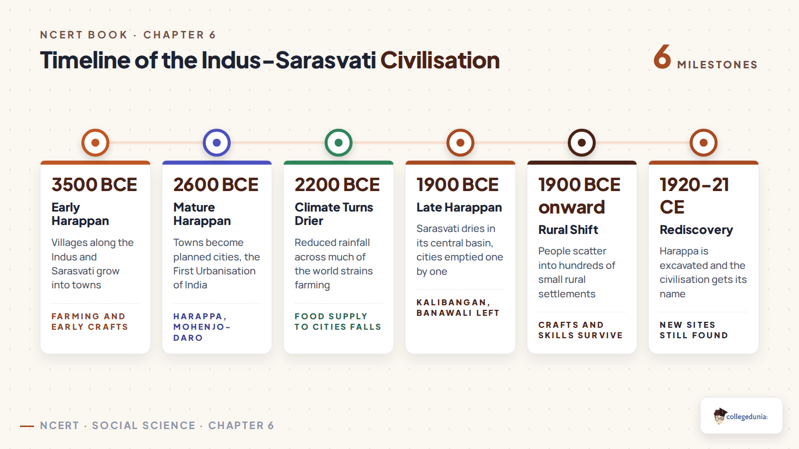
- From about 3500 BCE, villages in this whole region grew into towns.
- With growing trade and other exchanges, those towns grew into cities around 2600 BCE.
- The book calls this change the First Urbanisation of India.
Archaeologists gave the civilisation several names, and the chapter says plainly that it will use all of them: Indus, Harappan, Indus-Sarasvatī and Sindhu-Sarasvatī. Its people are called Harappans. The DON'T MISS OUT box on printed page 88 explains why: the city of Harappa, today in Pakistan's Punjab, was the first site of this civilisation to be excavated, back in 1920 and 1921, over a century ago.
Why the Book Drops the Term Indus Valley Civilisation
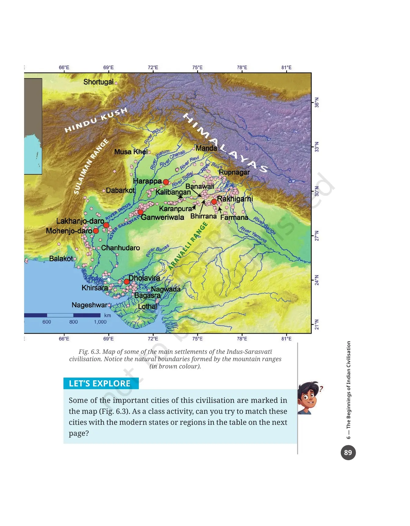
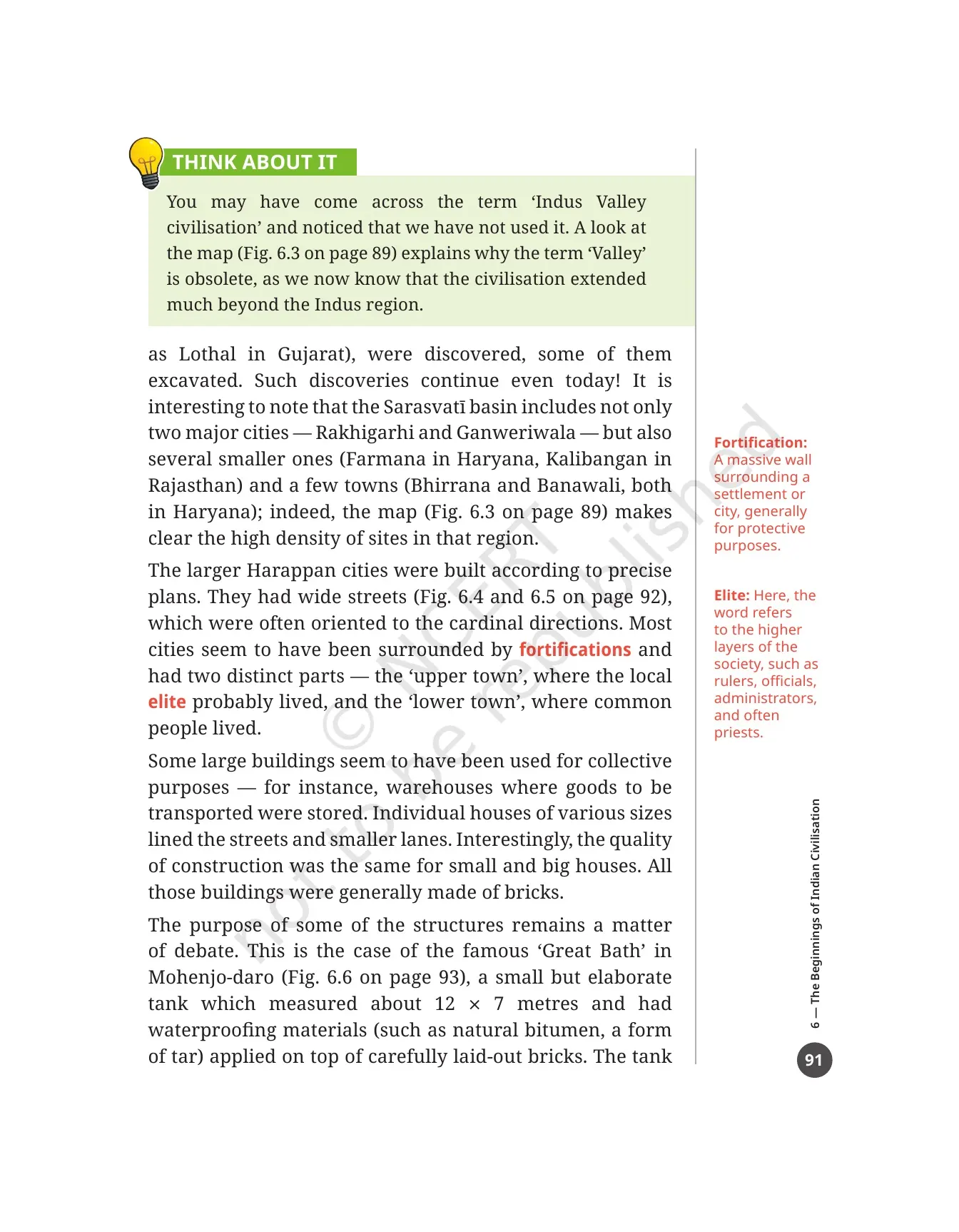
This is the trap question of the chapter, and the book flags it itself. The THINK ABOUT IT box on printed page 91 points out that you have probably heard the term Indus Valley civilisation, and that the chapter has not used it once. The word Valley is called obsolete because we now know the civilisation spread far beyond the Indus region. Fig. 6.3 on printed page 89 is the proof, and the book tells you to look at the map to see it.
The Sarasvatī side of the map carries a heavy load of sites, which is the whole reason for the name Indus-Sarasvatī. The section on printed page 90 adds what the river is called today and what the oldest text says about it.
- The Sarasvatī goes by the name Ghaggar in India and Hakra in Pakistan, so it is often called the Ghaggar-Hakra River.
- It is now seasonal, because it flows only during the rainy season.
- It is first mentioned in the Ṛig Veda, where it is worshipped both as a goddess and as a river flowing "from the mountain to the sea".
- Later texts describe the river drying up and eventually disappearing.
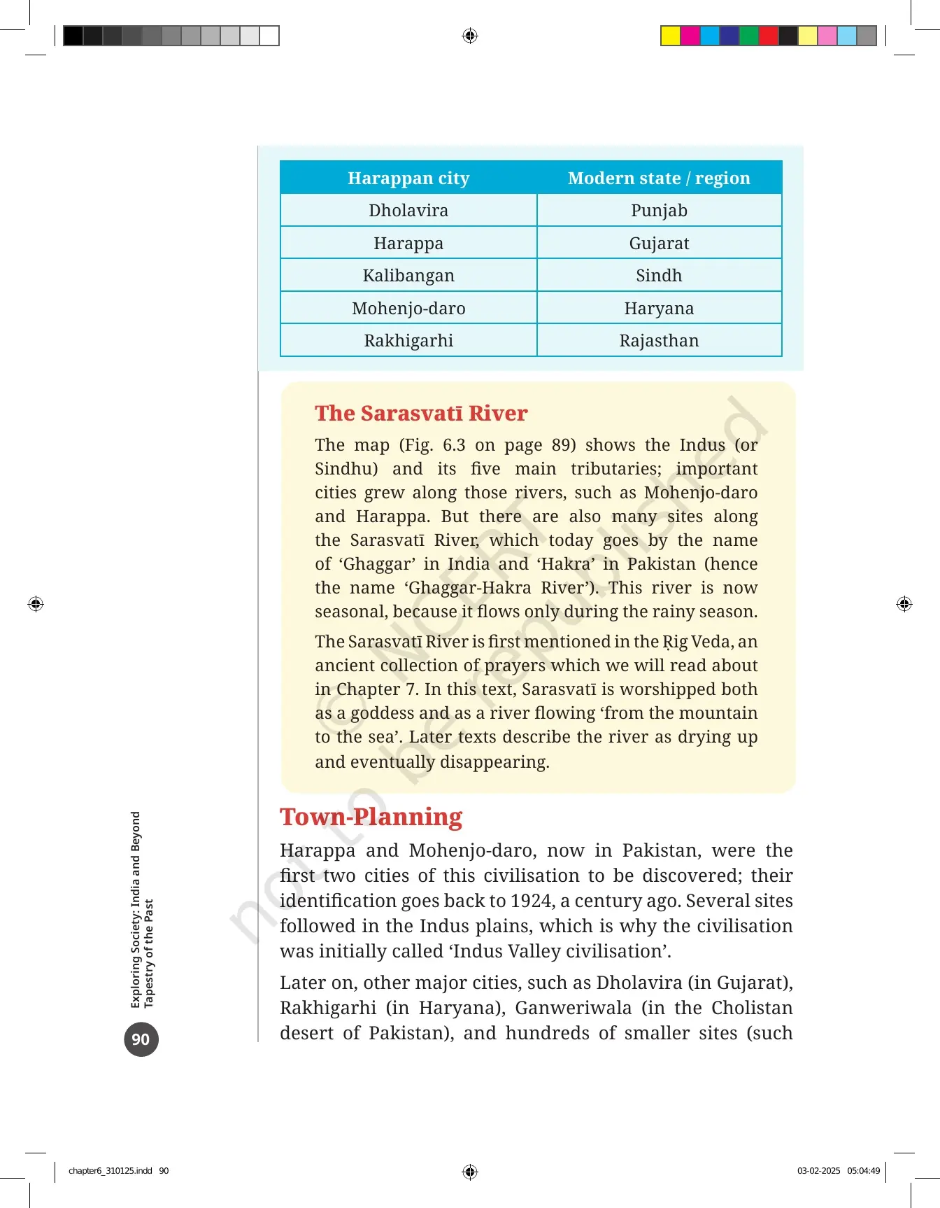
The LET'S EXPLORE box on printed page 89 asks you to match the cities on the map with their modern states or regions. The book prints the two columns out of order on purpose, so students often pair them wrongly. Here is the correct set, which is worth copying into your notebook once.
| Harappan city | Modern state or region |
|---|---|
| Dholavira | Gujarat |
| Harappa | Punjab |
| Kalibangan | Rajasthan |
| Mohenjo-daro | Sindh |
| Rakhigarhi | Haryana |
Town-Planning in Harappan Cities: Upper Town, Lower Town and the Great Bath
Harappa and Mohenjo-daro, both now in Pakistan, were the first two cities of this civilisation to be found, and the book dates their identification to 1924. Several more sites followed in the Indus plains, which is why the civilisation was first called the Indus Valley civilisation. Later, other major cities were discovered, and some were excavated.
| Site named in the chapter | Where it is | Why the book mentions it |
|---|---|---|
| Dholavira | Gujarat | A major city with three distinct zones and at least six large reservoirs |
| Rakhigarhi | Haryana | A major city in the Sarasvatī basin |
| Ganweriwala | Cholistan desert, Pakistan | The other major city of the Sarasvatī basin |
| Lothal | Gujarat | A small settlement with a huge basin, read as a dockyard |
| Farmana and Kalibangan | Haryana and Rajasthan | Smaller sites in the Sarasvatī basin |
| Bhirrana and Banawali | Both in Haryana | Towns that show the high density of sites in that region |
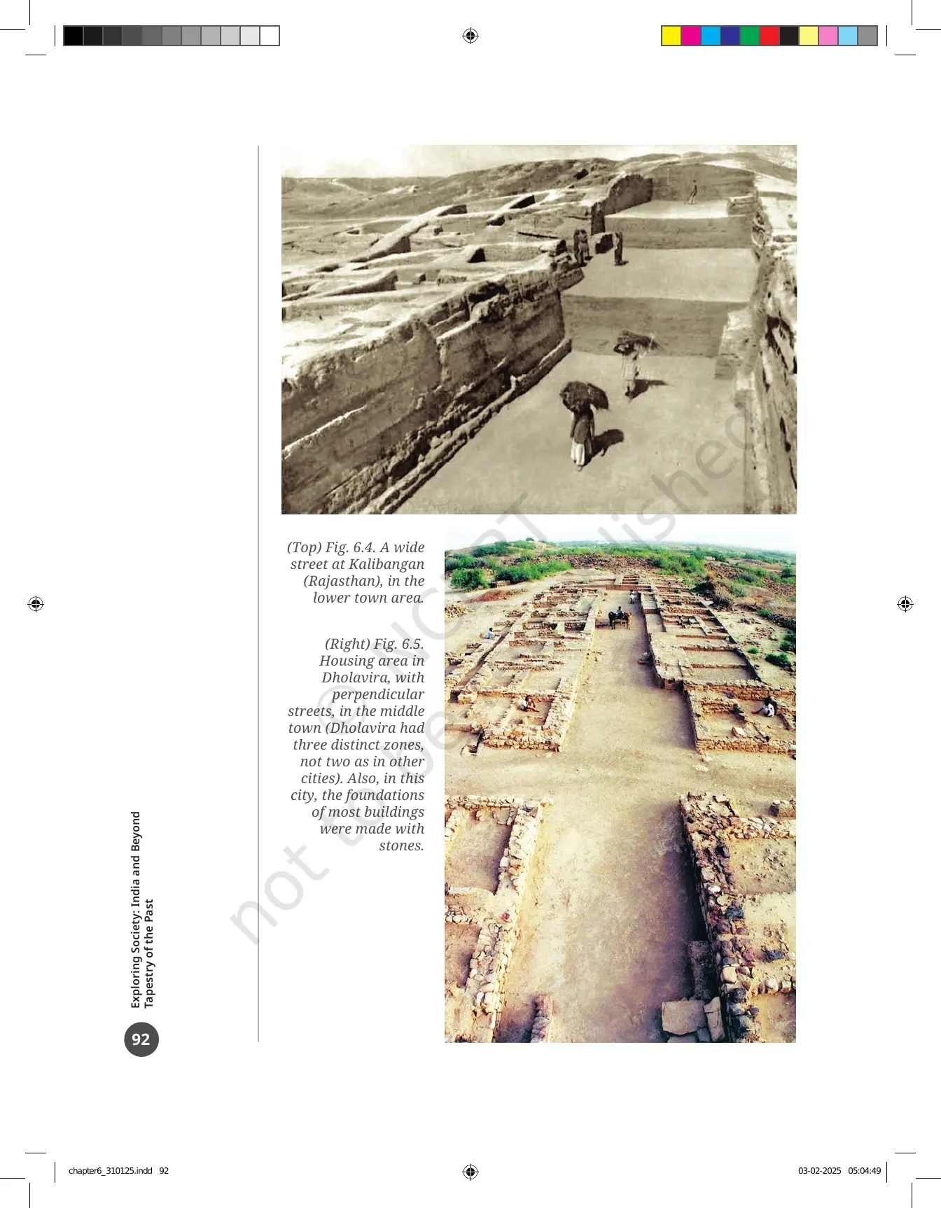
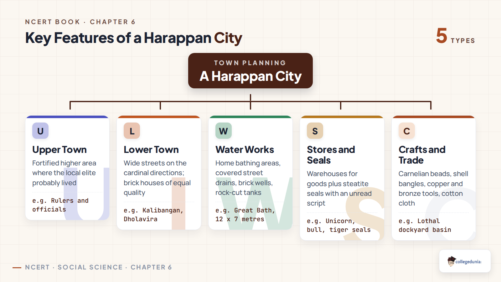
The larger Harappan cities were built to precise plans. They had wide streets, often lined up with the cardinal directions, which you can see in Fig. 6.4 at Kalibangan and Fig. 6.5 at Dholavira. Most cities were surrounded by fortifications, a massive protective wall, and had two distinct parts. The upper town is where the local elite probably lived, and the lower town is where common people lived. The margin word elite is defined as the higher layers of society, such as rulers, officials, administrators and often priests.
Three details from this section are easy to miss and often carry a mark on their own.
- Some large buildings were used for collective purposes, for example warehouses where goods to be transported were stored.
- Houses of various sizes lined the streets and lanes, and the quality of construction was the same for small and big houses.
- All those buildings were generally made of bricks, although at Dholavira the foundations of most buildings used stone. Dholavira also had three zones, not two as in other cities.
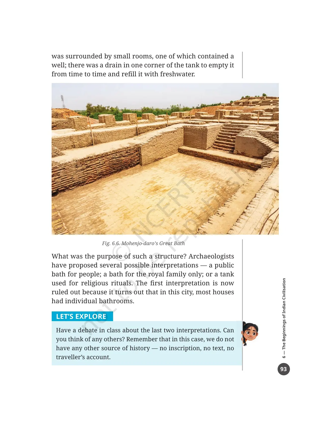
The famous Great Bath at Mohenjo-daro, shown in Fig. 6.6, is a small but elaborate tank measuring about 12 by 7 metres. Waterproofing materials such as natural bitumen, a form of tar, were laid on top of carefully placed bricks. Small rooms surrounded the tank, one of them holding a well, and a drain in one corner let the tank be emptied and refilled with freshwater.
What was it for? The book gives three possible answers and rules one out.
- A public bath for people. Now ruled out, because most houses in this city had their own bathrooms.
- A bath for the royal family only. Still open.
- A tank used for religious rituals. Also still open.
The LET'S EXPLORE box on printed page 93 asks the class to debate the last two, and to suggest others. It also reminds you why the debate cannot be settled: for this civilisation we have no inscription, no text and no traveller's account.
Water Management at Mohenjo-daro, Lothal and Dholavira
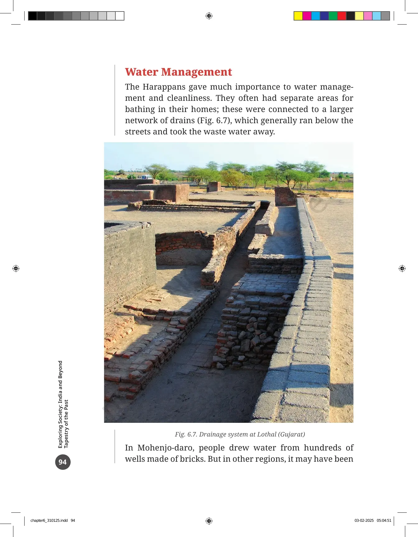
The Harappans gave a lot of importance to water management and cleanliness. Houses often had separate bathing areas, and these were joined to a larger network of drains that generally ran below the streets and carried waste water away. Fig. 6.7 shows this drainage system at Lothal in Gujarat.
Where the water came from changed from place to place, and the numbers here are the ones examiners like.
| Place | Water source | The number to remember |
|---|---|---|
| Mohenjo-daro | Wells made of bricks | Hundreds of wells; end question 7 puts the count at about 700 |
| Other regions | Ponds, nearby streams or human-made reservoirs | The margin word reservoir is defined here |
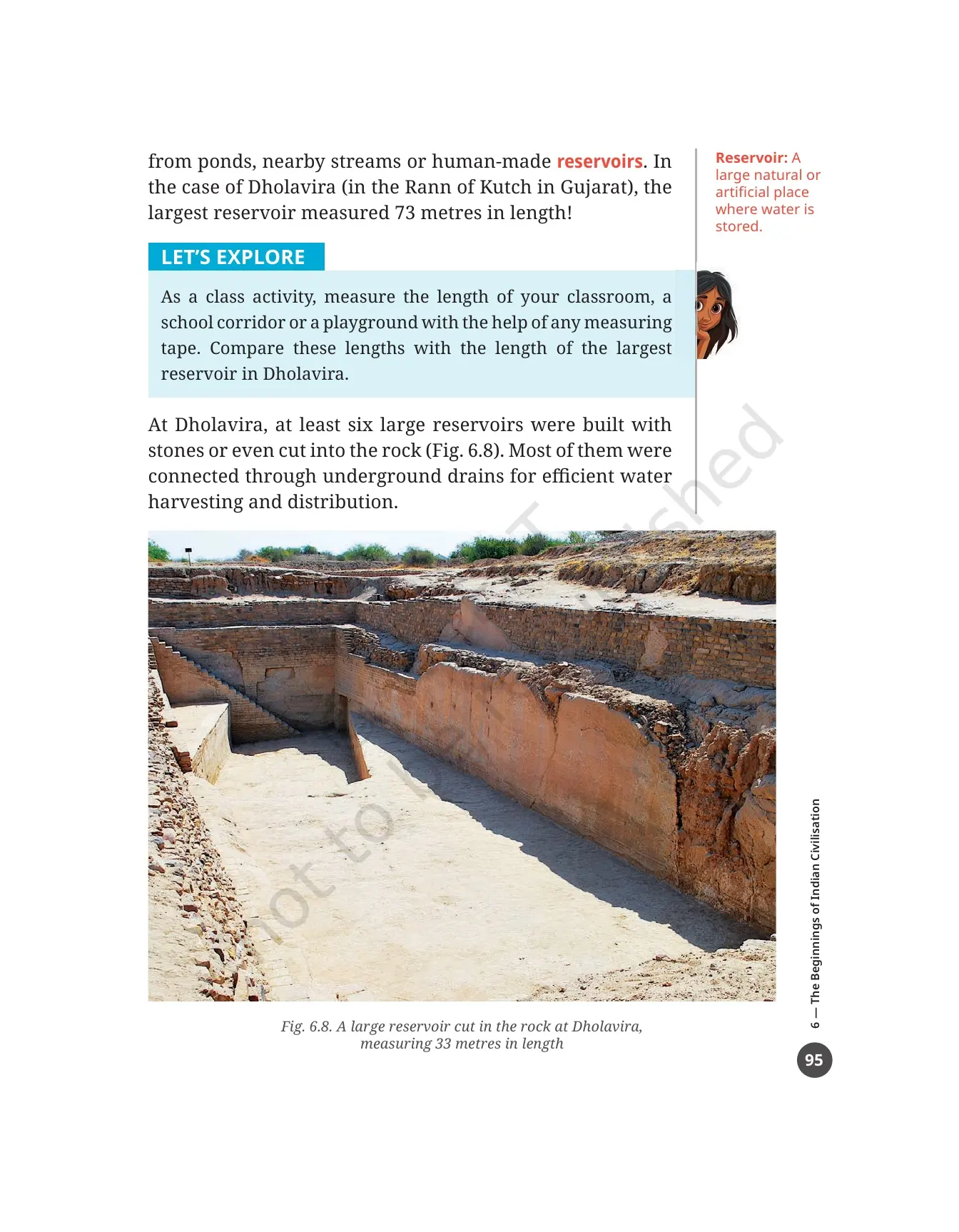
| Dholavira | Reservoirs built with stone or cut into the rock | At least six large reservoirs; the largest measured 73 metres in length |
| Fig. 6.8 at Dholavira | A reservoir cut into the rock | Measures 33 metres in length |
Most of the Dholavira reservoirs were joined by underground drains for efficient water harvesting and distribution. The LET'S EXPLORE box on printed page 95 turns this into a class activity: measure your classroom, a corridor or a playground, then compare that length with the largest reservoir at Dholavira.
The THINK ABOUT IT box on printed page 96 is the one that leads straight into an end question. It asks you to imagine the number of workers needed to build such a network. Who organised their work and gave them instructions? How were they paid, given that there was no money at that time in the way we have today? Was there a local authority to clean and maintain the reservoirs? The book says archaeologists discuss the same questions, and the answers are not always final.
What Did the Harappans Eat, Grow and Cook
The Harappans built many of their settlements along the banks of large or small rivers. That was a sensible choice, not only for easy access to water, but also for farming, because rivers enrich the soil around them. The margin word here is pulses, defined as a group of crops that includes beans, peas and lentils, which we call dal.
- They grew cereals such as barley, wheat, some millets and sometimes rice, along with pulses and a variety of vegetables.
- They were the first in Eurasia to grow cotton, which they wove into cloth.
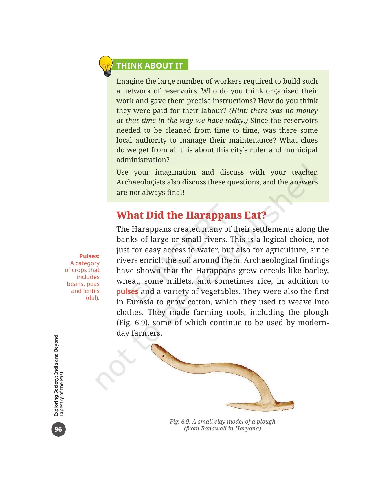
- They made farming tools including the plough. Fig. 6.9 is a small clay model of one, found at Banawali in Haryana, and some of these tools are still used by farmers today.
- They domesticated animals for meat and fished both in rivers and in the sea, which we know from the many animal and fish bones found during excavations.
Hundreds of small rural sites and villages managed all this farming. The book makes a point that is easy to quote in an answer: then as now, the cities could survive only if enough farm produce from rural areas reached them every day.
The most enjoyable part of this section is the cooking pots. Scientific tests on clay pots gave both expected results, such as dairy products, and surprising ones. Traces of turmeric, ginger and banana were found, so Harappan food was already quite varied. The LET US EXPLORE box then asks you to imagine cooking a meal in a Harappan house and to name the dish you would make from that list.
A Brisk Trade: Carnelian Beads, Shell Bangles, Lothal's Dockyard and the Seals
The Harappans traded actively, not only with other cities of their own civilisation but with other civilisations and cultures both inside and outside India. The chapter separates what went out from what probably came in, and that split is the safest way to learn this section.
| Direction | Goods named in the chapter | Evidence in the PDF |
|---|---|---|
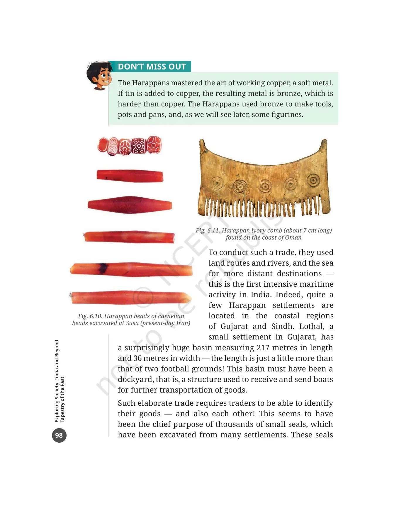
| Exported | Ornaments, timber, some objects of daily use, probably gold and cotton, possibly some food items | Fig. 6.11, a Harappan ivory comb about 7 cm long, found on the coast of Oman |
| Most favoured ornament | Beads of carnelian, a reddish semiprecious stone found mostly in Gujarat | Fig. 6.10, Harappan carnelian beads excavated at Susa in present-day Iran |
| Also worked | Conch shells, turned into shell bangles, which is hard because shell is a hard material | Described on printed page 97 |
| Imported | Not clearly known, but it probably included copper | The book says copper was not so common back home |
Two craft facts sit inside the DON'T MISS OUT box on printed page 98. The Harappans mastered the art of working copper, a soft metal. If tin is added to copper, the result is bronze, which is harder than copper. They used bronze for tools, pots and pans, and some figurines. Harappan craftspeople also developed special ways to drill carnelian beads so a string could pass through them, and to decorate them.
Trade needed routes. The Harappans used land routes and rivers, and the sea for more distant places. The book calls this the first intensive maritime activity in India, and quite a few Harappan settlements sit in the coastal regions of Gujarat and Sindh.
- Lothal, a small settlement in Gujarat, has a huge basin measuring 217 metres in length and 36 metres in width.
- That length is just a little more than two football grounds placed end to end.
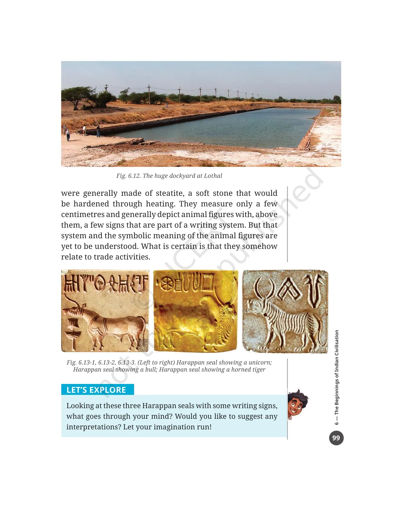
- The basin, shown in Fig. 6.12, must have been a dockyard, a structure used to receive and send boats so goods could travel further.
Traders also had to identify their goods and each other. That seems to be the main purpose of the thousands of small seals dug up at many settlements. They were generally made of steatite, a soft stone that was hardened by heating, and they measure only a few centimetres. Each usually shows an animal figure with a few signs above it that belong to a writing system. Neither that writing system nor the meaning of the animal figures has been understood yet, but the link to trade is certain. Figs. 6.13-1 to 6.13-3 show a unicorn seal, a bull seal and a horned tiger seal, and the LET'S EXPLORE box invites you to suggest your own reading of them.
The Lives of the Ancients: Objects of Daily Use and Cultural Objects on Pages 100 and 101
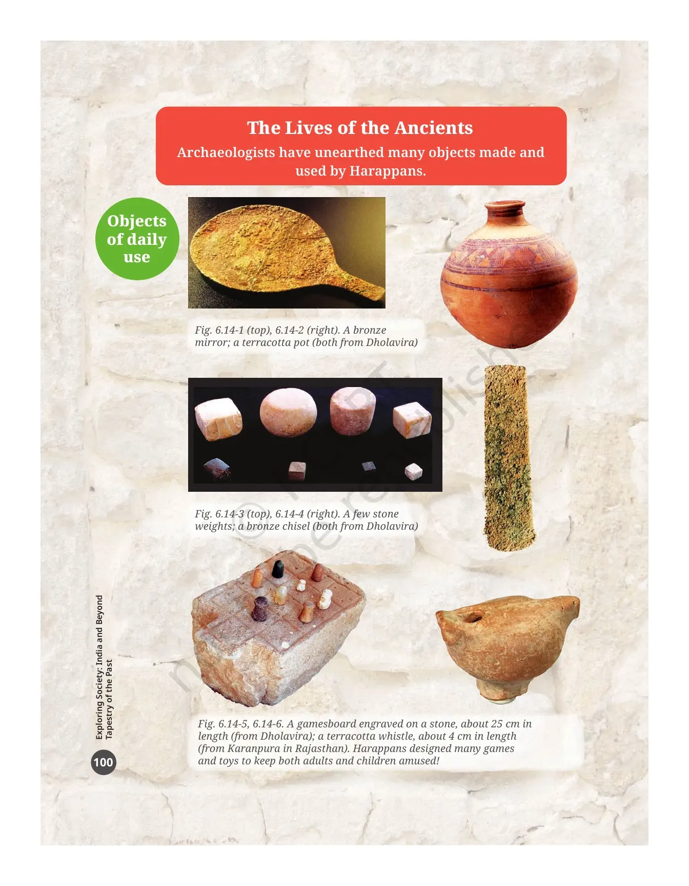
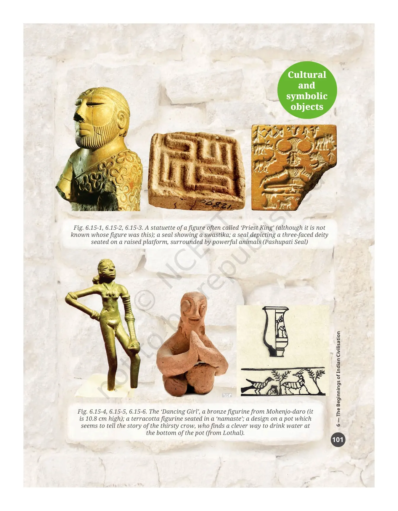
Two picture pages carry no running text, only captions, so students skim them and then lose marks on end question 5. Printed page 100 groups objects of daily use and printed page 101 groups cultural and symbolic objects. Learn them as two sets.
| Figure | Object | Where it is from |
|---|---|---|
| Fig. 6.14-1 and 6.14-2 | A bronze mirror and a terracotta pot | Both from Dholavira |
| Fig. 6.14-3 and 6.14-4 | A few stone weights and a bronze chisel | Both from Dholavira |
| Fig. 6.14-5 | A gamesboard engraved on a stone, about 25 cm long | Dholavira |
| Fig. 6.14-6 | A terracotta whistle, about 4 cm long | Karanpura, Rajasthan |
| Fig. 6.15-1 | A statuette often called the 'Priest King', although whose figure it is remains unknown | Cultural and symbolic objects page |
| Fig. 6.15-2 and 6.15-3 | A seal showing a swastika, and the Pashupati Seal with a three-faced deity on a raised platform surrounded by powerful animals | Cultural and symbolic objects page |
| Fig. 6.15-4 | The 'Dancing Girl', a bronze figurine 10.8 cm high | Mohenjo-daro |
| Fig. 6.15-5 and 6.15-6 | A terracotta figurine seated in a 'namaste', and a pot design that seems to tell the story of the thirsty crow | The pot design is from Lothal |
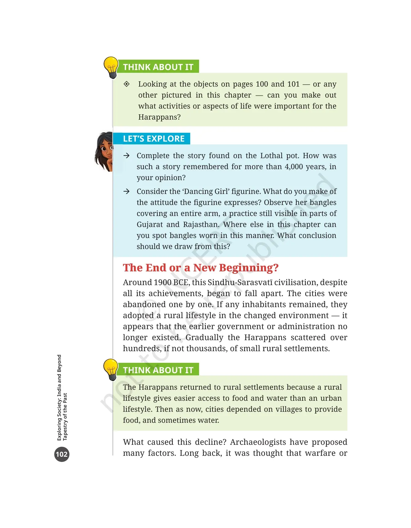
The book notes that the Harappans designed many games and toys to keep both adults and children amused. The LET'S EXPLORE box on printed page 102 then sets two tasks that reward a careful look. First, complete the story on the Lothal pot and say how such a story was remembered for more than 4,000 years. Second, look at the Dancing Girl's bangles covering an entire arm, a practice still seen in parts of Gujarat and Rajasthan, and find where else in the chapter bangles are worn that way.
The End or a New Beginning: Why the Harappan Cities Were Abandoned
Around 1900 BCE, the Sindhu-Sarasvatī civilisation began to fall apart despite all its achievements. The cities were abandoned one by one. Any people who stayed took up a rural way of life in the changed surroundings, and it looks as though the earlier government or administration no longer existed. Gradually the Harappans spread out over hundreds, if not thousands, of small rural settlements.
The book is careful about what did not cause the decline, and this is the highest-value line in the section.
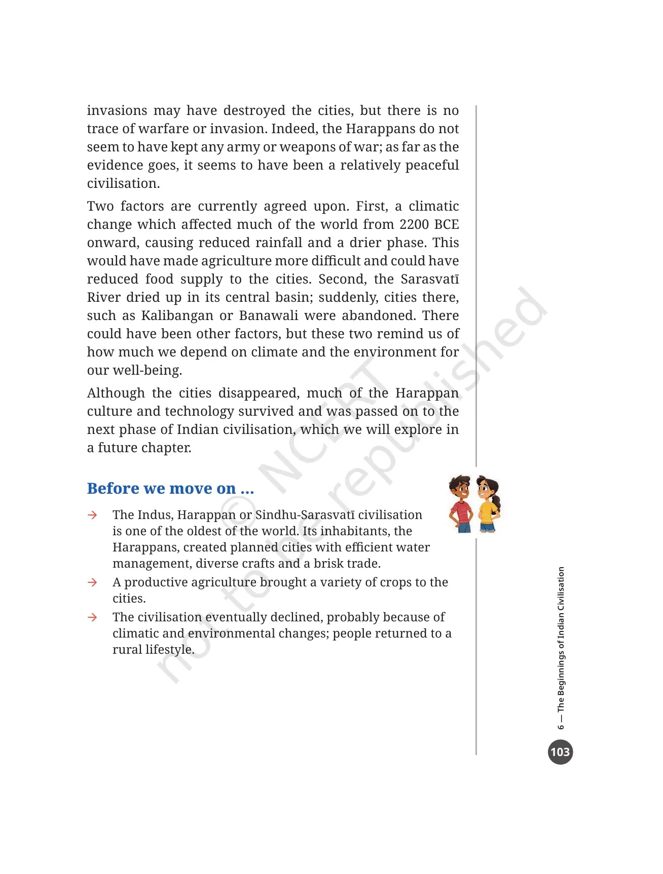
- It was long thought that warfare or invasions destroyed the cities, but there is no trace of warfare or invasion.
- The Harappans do not seem to have kept any army or weapons of war.
- As far as the evidence goes, it seems to have been a relatively peaceful civilisation.
Two factors are currently agreed upon, and both are about the environment rather than about people.
- A climatic change that affected much of the world from 2200 BCE onward, bringing reduced rainfall and a drier phase. That would have made farming harder and could have cut the food supply to the cities.
- The Sarasvatī River dried up in its central basin. Cities there, such as Kalibangan and Banawali, were suddenly abandoned.
The book adds that there could have been other factors, and closes with a line worth quoting: these two remind us how much we depend on climate and the environment for our well-being. Although the cities disappeared, much of the Harappan culture and technology survived and was passed on to the next phase of Indian civilisation. A THINK ABOUT IT box explains the move back to villages simply: a rural life gives easier access to food and water than an urban one.
Every Figure, Activity Box and Margin Word Inside the Beginnings of Indian Civilisation PDF
This chapter teaches through photographs and boxes as much as through paragraphs. Fifteen numbered figures do the visual work, six margin words carry the vocabulary, and fourteen boxes turn the reading into tasks. Tick them off as you go.
| Figure or box | Printed page | What it shows or asks |
|---|---|---|
| Fig. 6.1 | 85 | The North Gate entrance to Dholavira's 'Castle' area |
| Fig. 6.2 | 87 | A timeline placing the Indus-Sarasvatī civilisation from about 2600 to 1900 BCE beside Mesopotamia and Egypt |
| Fig. 6.3 | 89 | A map of the main settlements, with the natural boundaries formed by mountain ranges shown in brown |
| Figs. 6.4 and 6.5 | 92 | A wide street at Kalibangan, and the housing area at Dholavira with perpendicular streets in the middle town |
| Fig. 6.6 | 93 | Mohenjo-daro's Great Bath |
| Figs. 6.7 and 6.8 | 94 and 95 | The drainage system at Lothal, and a rock-cut reservoir at Dholavira measuring 33 metres |
| Fig. 6.9 | 96 | A small clay model of a plough from Banawali in Haryana |
| Figs. 6.10, 6.11 and 6.12 | 98 and 99 | Carnelian beads found at Susa in Iran, an ivory comb found on the coast of Oman, and the dockyard at Lothal |
| Figs. 6.13-1 to 6.13-3 | 99 | Seals showing a unicorn, a bull and a horned tiger |
| Figs. 6.14-1 to 6.14-6 | 100 | Objects of daily use: bronze mirror, terracotta pot, stone weights, bronze chisel, gamesboard and whistle |
| Figs. 6.15-1 to 6.15-6 | 101 | Cultural and symbolic objects: the 'Priest King', a swastika seal, the Pashupati Seal, the 'Dancing Girl', a 'namaste' figurine and the thirsty crow pot |
| THINK ABOUT IT boxes | 86, 91, 96 and 102 | The most fundamental characteristic, why 'Valley' is obsolete, who organised the reservoir workers, what the objects tell us, and why people went back to villages |
| LET'S EXPLORE boxes | 87, 89, 93, 95, 97, 99 and 102 | Professions, city and state matching, the Great Bath debate, measuring against the reservoir, cooking a Harappan meal, reading the seals, and the Lothal pot story |
| DON'T MISS OUT boxes | 88 and 98 | Why the people are called Harappans and what the First Urbanisation of India means, and how copper plus tin makes bronze |
| The Big Questions | 85 | What is a civilisation, what was the earliest civilisation of the Indian Subcontinent, and what were its major achievements |
| Margin words | 86, 88, 91, 95 and 96 | Metallurgy, Tributary, Fortification, Elite, Reservoir and Pulses |
| Before we move on ... | 103 | A three-point recap on the planned cities, the productive agriculture, and the climate-driven decline |
Questions, Activities and Projects at the End of the Beginnings of Indian Civilisation Chapter
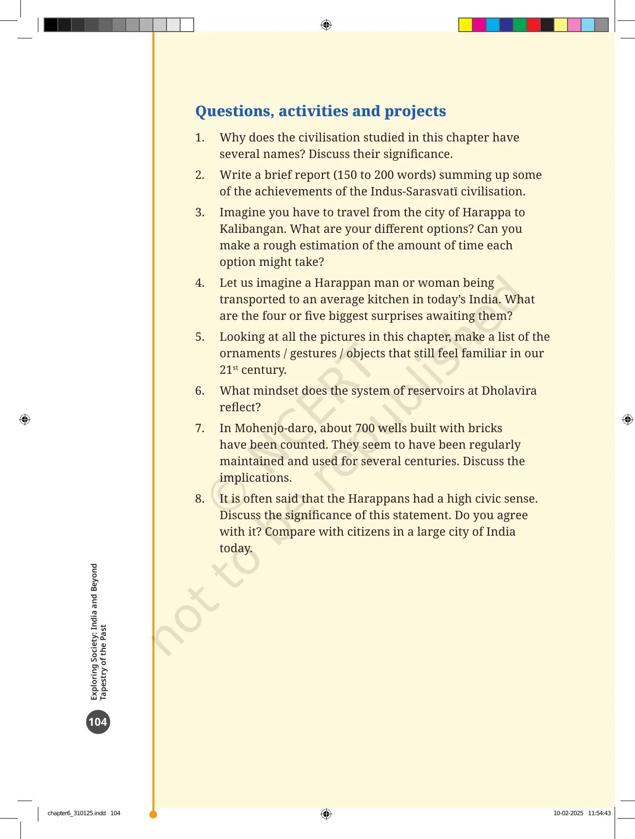
Printed page 104 carries 8 numbered items, and school tests are usually built straight out of them. Most are open-ended, so the marks go to students who quote a detail from the chapter rather than write a general answer.
- Why does this civilisation have several names? Discuss what each name means. Use Indus, Harappan, Indus-Sarasvatī and Sindhu-Sarasvatī.
- Write a brief report of 150 to 200 words summing up some of the achievements of the Indus-Sarasvatī civilisation.
- Travel from Harappa to Kalibangan. What are your options, and roughly how long would each take?
- A Harappan in a modern kitchen. Name the four or five biggest surprises waiting for them.
- Look at all the pictures in the chapter and list the ornaments, gestures and objects that still feel familiar in our 21st century.
- What mindset does the system of reservoirs at Dholavira reflect?
- About 700 brick wells at Mohenjo-daro were counted, regularly maintained and used for several centuries. Discuss what that implies.
- Did the Harappans have a high civic sense? Discuss the statement, say whether you agree, and compare with citizens of a large Indian city today.
Questions 2 and 8 carry the most marks in most school papers. For question 2, build the report from the five achievement headings the chapter itself uses: planned cities, water management, crafts, trade and productive agriculture. For question 8, use the drains under the streets, the same build quality for small and big houses, and the shared reservoirs as your evidence.
Common Mistakes Students Make in the Beginnings of Indian Civilisation Chapter
- Writing Indus Valley civilisation. The chapter avoids the term on purpose, because the civilisation spread far beyond the Indus region.
- Swapping the Great Bath and the dockyard. The Great Bath is at Mohenjo-daro and measures about 12 by 7 metres. The dockyard is at Lothal and measures 217 by 36 metres.
- Saying invaders destroyed the cities. The book states there is no trace of warfare or invasion, and no army or weapons of war.
- Mixing up the two dates. Villages grew into towns from about 3500 BCE. Towns grew into cities around 2600 BCE, and the decline began around 1900 BCE.
- Calling bronze a natural metal. Bronze is copper with tin added, and it is harder than copper.
- Claiming the Harappan script has been read. The signs on the seals and the meaning of the animal figures are still not understood.
Related Links:
- The Beginnings of Indian Civilisation Class 6 Handwritten Notes
- India, That Is Bharat Class 6 NCERT Book PDF
How to Read the Class 6 Beginnings of Indian Civilisation PDF in Two Sittings
This is one of the longer chapters in the book at 20 pages, and two picture pages need a slow look. Split it into two sittings of about 35 minutes each, with a rough sheet beside you for the dates and the site names.
- Sitting 1, minutes 0 to 12: read printed pages 85 to 88 and copy the seven characteristics of a civilisation with one example each.
- Sitting 1, minutes 12 to 22: study Fig. 6.3 on printed page 89, then fill the city and state table on printed page 90 without looking back.
- Sitting 1, minutes 22 to 35: read Town-Planning and Water Management on printed pages 90 to 95, and write down the Great Bath and Dholavira reservoir numbers.
- Sitting 2, minutes 0 to 15: read the food and trade sections on printed pages 96 to 99, and list the exports and imports in two columns.
- Sitting 2, minutes 15 to 25: spend ten slow minutes on the object pages 100 and 101, naming every figure aloud.
- Sitting 2, minutes 25 to 35: read the decline section on printed pages 102 and 103, and write the two agreed factors plus the no-warfare point.
Come back the next day for the eight end questions, because questions 2 and 8 need the whole chapter in your head at once. That second pass is what turns a chapter you have read into a chapter you can answer, and it is why students who keep the official PDF on their phone finish this theme faster than students working from guide books alone.
More Beginnings of Indian Civilisation Class 6 Resources
The book PDF gives you the printed chapter. These pages give you the answers, the revision layer and the last-day recap for the same chapter.
| Resource | What it gives you |
|---|---|
| The Beginnings of Indian Civilisation Class 6 NCERT Solutions | Step-by-step answers to all 8 questions, activities and projects, including the 150 to 200 word achievements report |
| The Beginnings of Indian Civilisation Class 6 Revision Notes | The seven characteristics, the site list, the trade goods and the decline factors in one short read |
| The Beginnings of Indian Civilisation Class 6 Handwritten Notes | A topper's handwritten pages with hand-drawn site maps and colour-coded sub-headings for a last-day recap |
| The Beginnings of Indian Civilisation Class 6 NCERT Book PDF | This page. The official 2026-27 chapter file, printed pages 85 to 104 of Exploring Society: India and Beyond |
NCERT Book PDF for Class 6 Social Science: All 14 Chapters
Exploring Society: India and Beyond runs to 14 chapters across five themes. Download the ones your school has taught, or take the full set in one go.
| Chapter | Resource |
|---|---|
| Chapter 1 | Locating Places on the Earth NCERT Book PDF |
| Chapter 2 | Oceans and Continents NCERT Book PDF |
| Chapter 3 | Landforms and Life NCERT Book PDF |
| Chapter 4 | Timeline and Sources of History NCERT Book PDF |
| Chapter 5 | India, That Is Bharat NCERT Book PDF |
| Chapter 6 | The Beginnings of Indian Civilisation NCERT Book PDF (this page) |
| Chapter 7 | India's Cultural Roots NCERT Book PDF |
| Chapter 8 | Unity in Diversity, or 'Many in the One' NCERT Book PDF |
| Chapter 9 | Family and Community NCERT Book PDF |
| Chapter 10 | Grassroots Democracy Part 1: Governance NCERT Book PDF |
| Chapter 11 | Grassroots Democracy Part 2: Local Government in Rural Areas NCERT Book PDF |
| Chapter 12 | Grassroots Democracy Part 3: Local Government in Urban Areas NCERT Book PDF |
| Chapter 13 | The Value of Work NCERT Book PDF |
| Chapter 14 | Economic Activities Around Us NCERT Book PDF |
Beginnings of Indian Civilisation Class 6 Social Science NCERT Book PDF FAQs
Common Questions on the Class 6 Social Science Chapter 6 File
Ques. Where can I download the NCERT Class 6 Social Science Chapter 6 The Beginnings of Indian Civilisation PDF?
Ans. You can download it directly from this page. It is the official NCERT chapter file for the 2026-27 print of Exploring Society: India and Beyond, and it is free.
Ques. How many pages is The Beginnings of Indian Civilisation chapter PDF?
Ans. The file runs to 20 pages. It covers printed pages 85 to 104 of the textbook, from the B.B. Lal passage on the opening page to the eight end questions on the last page.
Ques. What are the seven characteristics of a civilisation given in the chapter?
Ans. Printed page 86 lists government and administration, urbanism with town-planning and drainage, a variety of crafts, internal and external trade, some form of writing, cultural ideas expressed through art and customs, and a productive agriculture that can feed the cities as well as the villages.
Ques. Why does the chapter avoid the term Indus Valley civilisation?
Ans. The THINK ABOUT IT box on printed page 91 says the word Valley is obsolete, because we now know the civilisation extended much beyond the Indus region. The map in Fig. 6.3 on printed page 89 shows the many sites along the Sarasvatī as well.
Ques. Why are the people of this civilisation called Harappans?
Ans. The DON'T MISS OUT box on printed page 88 explains that the city of Harappa, today in Pakistan's Punjab, was the first site of this civilisation to be excavated, in 1920 and 1921, over a century ago. The whole development is also called the First Urbanisation of India.
Ques. What dates does the chapter give for the Indus-Sarasvatī civilisation?
Ans. Villages grew into towns from about 3500 BCE, and towns grew into cities around 2600 BCE. Fig. 6.2 dates the civilisation from about 2600 to 1900 BCE, and the decline starts around 1900 BCE.
Ques. What is the Sarasvatī River called today?
Ans. It goes by the name Ghaggar in India and Hakra in Pakistan, so it is often called the Ghaggar-Hakra River. It is now seasonal because it flows only during the rainy season. The Ṛig Veda mentions it as both a goddess and a river flowing from the mountain to the sea.
Ques. What was the Great Bath at Mohenjo-daro used for?
Ans. Nobody knows for certain. The tank measures about 12 by 7 metres and was waterproofed with natural bitumen over carefully laid bricks. Archaeologists suggest a public bath, a bath for the royal family only, or a tank for religious rituals. The first is ruled out because most houses in the city had their own bathrooms.
Ques. How big were the reservoirs at Dholavira?
Ans. At least six large reservoirs were built with stone or cut into the rock, and most were joined by underground drains. The largest measured 73 metres in length, and the rock-cut reservoir shown in Fig. 6.8 measures 33 metres.
Ques. What did the Harappans eat?
Ans. They grew barley, wheat, some millets and sometimes rice, plus pulses and a variety of vegetables. They domesticated animals for meat and fished in rivers and the sea. Tests on clay pots found dairy products along with traces of turmeric, ginger and banana.
Ques. What did the Harappans trade, and what was the Lothal dockyard?
Ans. They exported ornaments, timber, objects of daily use, probably gold and cotton, and possibly some food items, and probably imported copper. Lothal in Gujarat has a basin measuring 217 metres by 36 metres, a little longer than two football grounds, which must have been a dockyard for sending and receiving boats.
Ques. What are Harappan seals made of, and has the writing been read?
Ans. Thousands of small seals were made of steatite, a soft stone hardened by heating, and they measure only a few centimetres. Each usually shows an animal figure with signs above it. Neither the writing system nor the meaning of the animal figures has been understood yet, though the seals clearly relate to trade.
Ques. Why did the Harappan cities decline?
Ans. Two factors are currently agreed upon. A climatic change from about 2200 BCE brought less rainfall and a drier phase, which made farming harder. The Sarasvatī River then dried up in its central basin, and cities there such as Kalibangan and Banawali were abandoned. There is no trace of warfare or invasion.
Ques. How many questions are there at the end of The Beginnings of Indian Civilisation chapter?
Ans. There are 8 numbered items under "Questions, activities and projects" on printed page 104. They cover the several names of the civilisation, a 150 to 200 word achievements report, a travel task, a modern-kitchen task, a picture list, the Dholavira reservoirs, the 700 wells of Mohenjo-daro, and Harappan civic sense.
Ques. Do I need the NCERT Solutions if I already have the book PDF?
Ans. The book PDF carries the questions but not the answers. Use the The Beginnings of Indian Civilisation Class 6 NCERT Solutions to check all 8 end questions and every activity box.



Comments