History Strategist, UPSC Mentor | Updated on - Jul 21, 2026
The NCERT Solutions for An Imperial Capital Vijayanagara Class 12 History Chapter 7 answer every textbook question on the Vijayanagara Empire and the ruins of Hampi, as per the latest 2026-27 CBSE syllabus. Each answer is built from the archaeological survey, the inscriptions and the foreign traveller accounts that historians use to rebuild this lost capital. These solutions help students prepare for the Class 12 History board paper in 2026-27.
Covers all 12 exercise questions from Theme 7, with full source-based and long-answer points.
This Class 12 History chapter usually carries 6 to 8 marks per board paper.
Pairs with the Notes, Handwritten Notes and NCERT Book PDF linked lower on this page.
Every solution for class 12 history chapter 7 in this Collegedunia compilation is curated by subject experts, written from the official NCERT Themes in Indian History Part II, and checked against the last five years of CBSE board papers.
Student Feedback: In a Collegedunia poll of 10,720 Class 12 History students taken before the 2026 boards, 69% of students rated the "royal centre" and water-supply questions as the trickiest part of An Imperial Capital Vijayanagara. Most students said sorting the city into its sacred, royal and urban zones made the long answers click.
Source: 2026-27 Class 12 History student poll. Sample of 10,720 students from CBSE schools across 13 states.
What the An Imperial Capital Vijayanagara Class 12 Chapter Is About
An Imperial Capital Vijayanagara is the seventh chapter of Themes in Indian History Part II. It studies the Vijayanagara Empire and its capital city, whose ruins survive today at Hampi on the Tungabhadra river in Karnataka. The empire flourished between roughly 1336 CE and 1565 CE, and the chapter shows how historians rebuild a city from its ruins, its inscriptions and the writings of foreign visitors.
The chapter is easiest to revise if you split the city into its three working parts:
The sacred centre on the rocky river bank, with the Virupaksha and Vitthala temples.
The royal centre in the south-west, with the mahanavami dibba, the Lotus Mahal and the elephant stables.
The urban core, where ordinary people lived, traded and farmed inside the fortified land.
So the chapter is really about reading a ruined city as evidence. A student who keeps the three zones in mind can connect almost any question in chapter 7 history class 12 back to one of them. This is why vijayanagara class 12 revision works best when you sort each building and ritual under the sacred, royal or urban zone first.
The Founding, Rulers and Rediscovery of Vijayanagara
Knowing who built the city and when it was found again helps students date every answer correctly. The empire passed through four dynasties before it fell, and the ruins were mapped only in the 1800s.
Founding: the brothers Harihara and Bukka set up the empire in 1336; this was the Sangama dynasty.
Four dynasties: Sangama, then Saluva, then Tuluva, then Aravidu ruled in turn.
Greatest ruler:Krishnadeva Raya of the Tuluva line (1509 to 1529) marked the empire's peak.
Rediscovery: Colonel Colin Mackenzie produced the first survey of the ruins in 1800.
The empire fell in 1565 at the battle of Talikota (also called Rakshasi-Tangadi), when an alliance of the Deccan Sultanates routed the forces led by Rama Raya and sacked the city. After that the capital was abandoned, which is why the ruins survive so well today.
Water Supply and Fortifications of Vijayanagara
Two exercise questions deal with how the city was supplied with water and why its walls enclosed farmland. Both ask students to weigh planning against cost, so the points should be set out clearly.
Feature
What it shows
Tungabhadra basin
The river and hill streams formed a natural water source for the city.
Tanks and embankments
Streams were dammed to make reservoirs; the Kamalapuram tank was the most important.
The Hiriya canal
Drew water from the river to irrigate fields between the sacred and urban centres.
Seven walls
Abdur Razzaq counted seven lines of forts ringing the city and its farmland.
Enclosed fields
Walls took in farms and forests so the city could feed itself in a siege.
The key insight for the fortification question is the trade-off. Enclosing farmland defeated the usual siege strategy of starving a city, but it was very expensive and meant a much larger area to defend. Strong answers list both sides, then note that the rulers chose food security over cost. This is what earns full marks in Question 7.3.
The Royal Centre, Mahanavami Dibba and Court Buildings
The royal centre holds several of the chapter's most-asked buildings, and it feeds three exercise questions. Students must be ready to describe what these structures tell us about the rulers who built them.
The mahanavami dibba: a massive platform used for the ten-day Mahanavami festival, where the king displayed power.
The rituals: they showed royal prestige, bound the nayakas to the king, and paraded the army.
The Lotus Mahal: a courtly building that blends arches and domes with Indian temple features.
The elephant stables: grand domed chambers that show the wealth and military pride of the court.
For the "royal centre" question, the honest answer is that the name fits only loosely, because the zone mixes palaces, temples and ritual platforms rather than purely royal buildings. The Lotus Mahal and elephant stables, with their blend of Islamic arches and Hindu styles, show rulers who borrowed freely and built on a grand scale. Keep this blend point ready for Questions 7.4, 7.6 and 7.7.
The Sacred Centre, Temples and Architecture
The sacred centre sits on the rocky northern bank and holds the great temples. Two questions ask about the architecture and the traditions that shaped it, so students should learn the named temples and their features.
The Virupaksha temple: dedicated to a form of Shiva, the empire's guardian deity, and active long before the city rose.
The Vitthala temple: famous for its stone chariot and pillared halls in the sacred centre.
Gopurams: towering gateways the Vijayanagara kings raised to mark royal patronage.
Mandapas and corridors: pillared halls and long pillared streets added for festivals and markets.
For Question 7.8, the point to make is that the architects drew on older Dravidian temple traditions, then transformed them with taller gopurams, grand mandapas and long pillared bazaar streets. The sculpted pillars in Fig. 7.33 carry floral motifs, animals and human figures, which Question 7.5 asks students to read closely. Describe what you actually see, then suggest why each motif was carved.
Life of Ordinary People and the Decline of the City
The chapter is not only about kings and temples. One question asks what the descriptions tell us about common people, and the closing section explains how the city fell. Both reward careful, evidence-based answers.
Theme
Key points to recall
Ordinary lives
Travellers note busy bazaars, crowded markets, festivals, and many soldiers, traders and craftspeople.
What is missing
Most accounts focus on courts and temples, so daily life is glimpsed only in passing.
Decline
Defeat at Talikota in 1565 led to the sack and abandonment of the capital.
One sharp exam point: foreign travellers such as Abdur Razzaq, Domingo Paes and Nuniz give the liveliest pictures of the city, but they wrote as outsiders, so their accounts must be read with care. For Question 7.9, gather the scattered details about markets, festivals and crowds, and note honestly that the sources tell us far less about the poor than about the court.
An Imperial Capital Vijayanagara Exercise-wise Coverage
The chapter exercise has 12 questions. The table maps each one to its topic so students can plan revision and find the right NCERT answer fast. The full step-by-step solution for each sits in the question set lower on this page.
Question
Topic it tests
Q 7.1
Methods used to study the ruins of Hampi and how they help the priests' account
Q 7.2
How the water needs of the city were met
Q 7.3
Advantages and disadvantages of enclosing farmland within the walls
Q 7.4
Significance of the rituals at the mahanavami dibba
Q 7.5
Source-based reading of the sculpted pillar in Fig. 7.33
Q 7.6
Whether "royal centre" is an apt name for that part of the city
Q 7.7
What the Lotus Mahal and elephant stables tell us about the rulers
Q 7.8
Architectural traditions that inspired the architects and how they changed them
Q 7.9
Impression of the lives of ordinary people
Q 7.10 to 7.12
Map work and project-style activities
Questions 7.4, 7.6 and 7.8 are the most-asked long answers, so students preparing chapter 7 history class 12 revision should learn those three first. The map and project tasks (7.10 to 7.12) are also useful for the history project file class 12 chapter 7 that many schools assign.
Students who want the offline copy can save the class 12 history chapter 7 pdf from the download card above and tick off each question as they finish it.
An Imperial Capital Vijayanagara Important Questions and Previous Year Trends
CBSE sets a steady mix of source-based, short and long answers from this chapter. Knowing the pattern helps students decide how much to write. The chapter is a regular source of one 5-mark or 8-mark source-based question, which is why a focused list of chapter 7 history class 12 important questions saves a lot of revision time.
Source-based (often 8 marks): a passage on the Mahanavami festival, the water works or a traveller's account, with three sub-parts.
Long answer (5 to 6 marks): features of the royal centre, or the architecture of the Lotus Mahal and temples.
Short answer (3 marks): the water supply, the fortifications, or the four dynasties.
Objective and MCQ: dates, ruler names, and who surveyed the ruins.
For quick recall before the exam, students often practise the class 12 history chapter 7 mcq set and a list of class 12 history chapter 7 important questions. The most repeated history class 12 chapter 7 question answer items are the mahanavami dibba rituals and the temple architecture, so keep those answer points ready in your own words.
It also helps to attempt a short history class 12 chapter 7 mcq drill and the class 12 history chapter 7 extra questions and answers after you finish the main exercise. These extra sets test the small facts, such as exact dates and ruler names, that examiners use for one-mark objective questions.
Working through the ncert solution class 12 history chapter 7 set twice, once open-book and once from memory, fixes those facts well before the board exam.
Common Mistakes Students Make in the Vijayanagara Chapter
A few errors cost marks every year in this chapter. Most come from mixing up the city's zones or naming the wrong ruler. Avoiding them is the fastest way to lift a score.
Confusing the sacred centre with the royal centre - learn which buildings sit where.
Naming the wrong founder - it was Harihara and Bukka in 1336, not Krishnadeva Raya.
Saying the city fell to one Sultanate - it was an alliance of the Deccan Sultanates at Talikota.
Treating the Lotus Mahal as purely Islamic or purely Hindu - it is a blend of both styles.
Forgetting that the walls enclosed farmland - this is the key fortification point.
Students who fix these five points usually move from average to high marks on the long answers. The exam rewards careful wording, so write "scholars suggest" or "the chapter shows" when you draw a conclusion from the evidence.
An Imperial Capital Vijayanagara PDF Download Formats and Languages
The solutions are free to download in more than one format, so students can pick what suits their device and revision style. The download card at the top of the page carries each option for this chapter.
Normal and HD PDF: the class 12 history chapter 7 pdf is offered in a normal size for quick downloads and an HD version for clear printing.
English medium: all 12 answers are written in simple English for the CBSE board paper.
Question-only set: a print-and-practise sheet of class 12 history chapter 7 extra questions for self-testing.
Whole-book pack: the chapter 7 history class 12 ncert solutions sit in one set that runs through every theme, so you can revise the whole book in one place.
Many students search for class 12 chapter 7 history answers on their phone the night before a test, so a saved PDF means you can revise even without internet. Keep both the question set and the solved version handy for a full self-check.
How the Vijayanagara Solutions Pair with Notes and the Book PDF
These NCERT Solutions answer the back-exercise questions. To revise the full chapter, students should use them alongside the other resources for the same chapter, all linked in the table below.
Reading the original NCERT chapter text and figures
Tip: read the Notes first, then attempt these solutions on your own, and only then check the model answers here. That order builds memory faster than copying answers straight away.
All NCERT Solutions for Class 12 History Chapter 7 An Imperial Capital Vijayanagara
The table links the NCERT Solutions for every chapter in Themes in Indian History so students can move across the book in one click. Chapter 7 is highlighted.
All NCERT Solutions for An Imperial Capital Vijayanagara with Step-by-Step Solutions
Below are all 12 NCERT exercise questions for this chapter, exactly as they appear in the textbook. Tap Check Solution for the model answer or Expert Solution for the topper-style approach.
Q 7.1
What have been the methods used to study the ruins of Hampi over the
last two centuries? In what way do you think they would have complemented the
information provided by the priests of the Virupaksha temple?
Concept used.Studying ruins means using many kinds of
evidence to reconstruct a past city: survey maps, photographs, inscriptions,
travellers' accounts and archaeological survey. The priests of the
Virupaksha temple were a living source, the local memory and oral tradition
that first led scholars to the site.
The methods used over the last two centuries were:
Surveying and mapping. The ruins were brought to light in
1800 by Colonel Colin Mackenzie, an engineer and
antiquarian of the East India Company, who prepared the first
survey map of the site.
Photography. From 1856, photographers began to record
the monuments, which let scholars study them closely and from a
distance.
Collecting inscriptions (epigraphy). As early as 1836
epigraphists started collecting several dozen inscriptions
found at the Virupaksha and other temples at Hampi.
Combining written sources. Historians collated all this with
the accounts of foreign travellers and literature in Telugu,
Kannada, Tamil and Sanskrit.
How these complemented the priests. The priests gave the
starting thread: oral traditions and memories about the shrines of
Virupaksha and Pampadevi that pointed Mackenzie to the right place and named
the living deities. The surveys, photographs and inscriptions then supplied
the firm dates, plans and details that oral memory alone could not. One
recovered names and rituals, the other recovered chronology and structures, so
together they gave a fuller history.
Pair "living memory" with "hard evidence"
The mark for the second half is in showing they fit together: the priests gave
names, cults and continuity; the surveys and inscriptions gave dates, maps and
proof. State that division of labour clearly.
The ruins were studied by survey and mapping (Colin Mackenzie, 1800),
photography (from 1856), collecting inscriptions (from 1836), and combining
travellers' accounts and Telugu, Kannada, Tamil and Sanskrit literature. These
complemented the Virupaksha priests by adding firm dates, plans and structural
detail to the living memory, oral traditions and names the priests preserved.
AS
Ananya Sengupta
MA Medieval Indian History, JNU
Verified Expert
Strategic angle. Split the answer cleanly: first list the
methods as a numbered set, then answer the "complement" half as a single
contrast. The examiner is scanning for both the list and the link, so do not
let the second half disappear into the first.
Name the methods in order of date so they read as a real research
story: Mackenzie's 1800 survey map, photography from 1856, inscription
collection from 1836, then the cross-checking of traveller accounts and
four-language literature.
State what each kind of source recovers: maps recover layout,
photographs recover the look of standing structures, inscriptions
recover donations, dates and events, travellers recover daily life.
Frame the priests as the oral, living source that survived the city's
ruin, then say plainly how the two kinds of evidence correct and
complete each other.
Why this matters. The deeper point, worth a closing line, is that no
single method is enough. Oral tradition alone can drift or forget; inscriptions
and ruins alone are silent about meaning and continuity. The historian's craft
here is triangulation, putting the priests' memory, the surveyor's map,
the epigraphist's inscriptions and the traveller's diary side by side until
they agree. Showing that you understand why many sources are needed,
rather than just listing them, is what lifts this from a recall answer to a
genuinely historical one.
Methods: Mackenzie's survey map (1800), photography (1856 onward),
collecting inscriptions (1836 onward), and collating travellers' accounts with
Telugu, Kannada, Tamil and Sanskrit literature. They complemented the
Virupaksha priests by turning living memory and oral tradition into dated,
mapped and documented history, each source filling the other's gaps.
Q 7.2
How were the water requirements of Vijayanagara met?
Concept used.Water management in a city means storing and
moving water for drinking, household use and irrigation. Vijayanagara sat in
one of the most arid zones of the peninsula, so it needed elaborate
arrangements to capture and carry water.
The water requirements were met in these ways:
The natural basin of the Tungabhadra. The most striking
feature of the site was the natural basin formed by the river
Tungabhadra, which flows in a north-easterly direction.
Granite hills around the city sent a number of streams down to
the river.
Embankments and reservoirs. In almost all cases
embankments were built along these streams to create
reservoirs (tanks) of varying sizes, storing the rainwater of
this dry region.
The Kamalapuram tank. The most important tank, built in the
early fifteenth century and now called the Kamalapuram tank,
irrigated nearby fields and was also conducted by a channel to the
royal centre.
The Hiriya canal. One of the most prominent waterworks among
the ruins, the Hiriya canal, drew water from a dam across the
Tungabhadra and irrigated the cultivated valley that separated the
sacred centre from the urban core. It was built by kings
of the Sangama dynasty.
For ordinary town dwellers, field surveys suggest that wells,
rainwater tanks and temple tanks served as everyday sources of water.
Why water shaped the whole city
Because this was an arid zone, controlling water was a matter of survival.
The tanks and canals decided where fields, temples and the royal centre could
sit, so the waterworks literally shaped the plan of Vijayanagara.
Vijayanagara used the natural basin of the Tungabhadra, building
embankments to turn hill-streams into reservoirs. The chief tank, the
Kamalapuram tank, irrigated fields and fed the royal centre by channel, while
the Hiriya canal drew water from a dam across the river to irrigate the valley
between the sacred centre and the urban core. Wells and temple tanks served
ordinary dwellers.
PS
Pranav Sharma
MA History, University of Delhi
Verified Expert
Structural observation. This is really a "list the waterworks"
question, so a tight ordered set scores best: the river basin, then the tanks,
then the canals, then the wells for ordinary people. Name each structure, since
named examples earn the marks.
Open with the geography: the Tungabhadra basin ringed by granite hills
is why the system existed, the hills gave streams, the dry
climate forced storage.
Name the two big works precisely: the Kamalapuram tank (early
fifteenth century, fed the royal centre) and the Hiriya canal (a
Sangama-dynasty work that watered the valley between the sacred centre
and urban core).
Close with the ordinary level: wells, rainwater tanks and temple tanks
for the town's people, so the answer covers both grand and everyday
water supply.
Why this matters. The strongest answers connect the waterworks to the
city's other features: the canal-fed agricultural belt inside the walls (Q3) is
only possible because of this elaborate water system, and the diversion of the
Kamalapuram tank's water to the royal centre shows the rulers prioritising
their own quarter. Tying the water system to the city's defence and layout, not
just listing tanks, is what a top answer does.
By harnessing the Tungabhadra's natural basin and the hill-streams:
embankments made reservoirs, the Kamalapuram tank (early 1400s) irrigated
fields and fed the royal centre, and the Hiriya canal (Sangama dynasty) watered
the valley between the sacred centre and urban core. Wells and temple tanks
supplied ordinary townspeople.
Q 7.3
What do you think were the advantages and disadvantages of enclosing
agricultural land within the fortified area of the city?
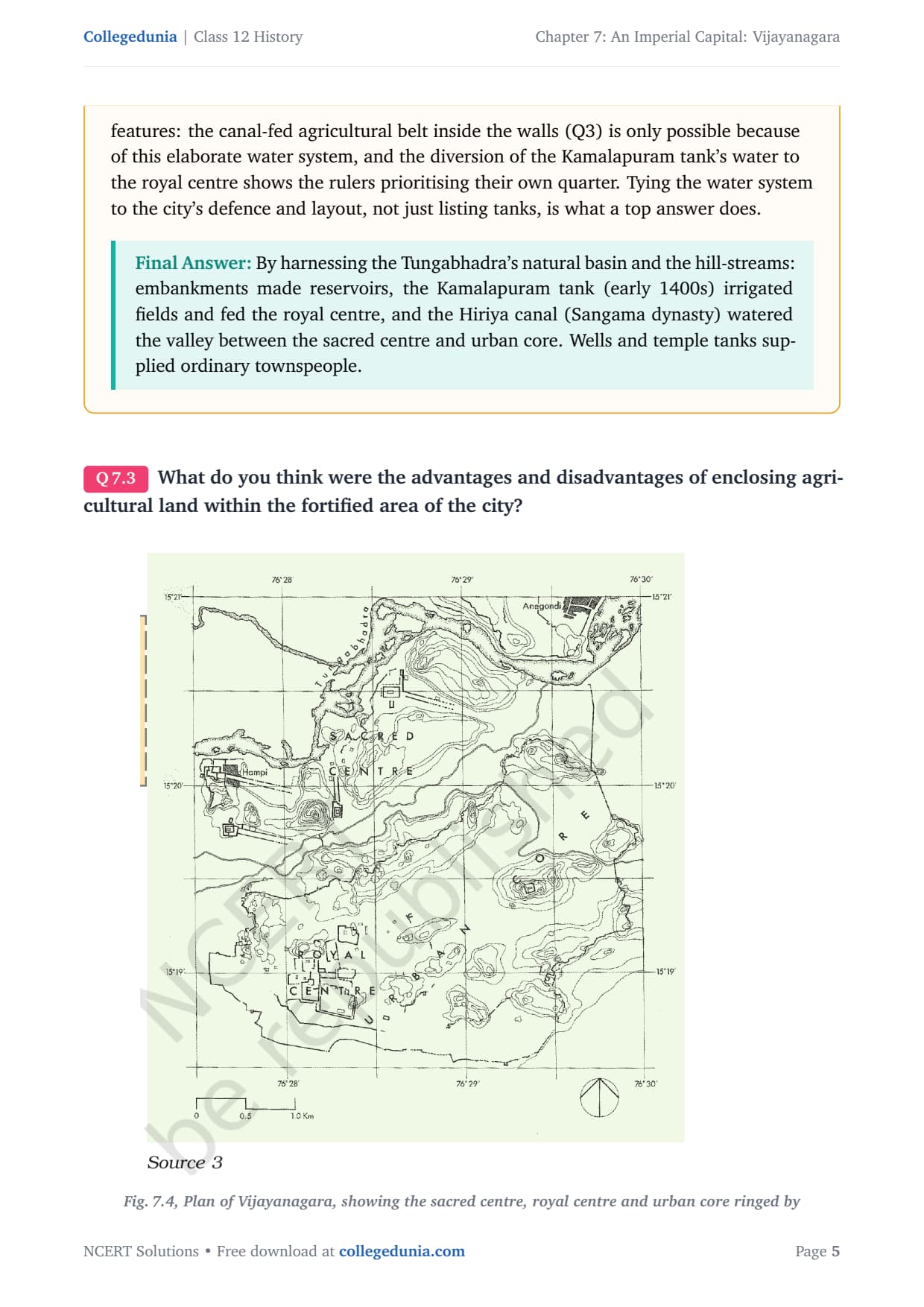
Fig. 7.4, Plan of Vijayanagara, showing the
sacred centre, royal centre and urban core ringed by fortifications. NCERT
Themes in Indian History, Part II, Class 12 History, Theme 7.
Concept used.Fortification normally walls in only the built
city. Vijayanagara was unusual: Abdur Razzaq counted seven lines of
forts that enclosed not just the city but its agricultural hinterland
and forests too. The question asks you to weigh that strategy.
Advantages of enclosing farmland:
It defeated the siege strategy. The usual aim of a medieval
siege was to starve the defenders into surrender, and sieges
could last months or even years. By protecting the farms themselves,
the rulers made sure the city could keep growing its own food
through a long siege.
More secure than granaries. Other rulers stored grain in
granaries within the fort, but stored grain runs out. Enclosing the
living agricultural belt meant a renewing food supply, a safer
if costlier plan.
It protected people and water too. The enclosed tracts, with
their fields, gardens and water from the Tungabhadra canals, kept
farmers, produce and water sources safe inside the walls.
Disadvantages:
It was very expensive. The chapter calls this a "more
expensive and elaborate strategy". Walling a huge area of fields needed
enormous lengths of masonry, labour and upkeep.
A larger area to defend. The longer the walls, the more
soldiers and resources were needed to guard every stretch, stretching
the army thin.
Lead with the siege logic
The single best advantage is the answer to siege warfare: protecting the fields
beats stockpiling grain. State that first, then the cost and the defence burden
as the disadvantages, for a balanced answer.
Advantage: enclosing farmland (as Vijayanagara did within its seven
walls) let the city keep growing food through long sieges, a renewing supply
safer than granary stockpiles, and kept farmers and water safe inside.
Disadvantage: it was hugely expensive in masonry and labour, and a much larger
walled area was harder and costlier to defend.
MK
Meera Krishnan
MA Archaeology, Deccan College Pune
Verified Expert
Strategic angle. The verb pair is "advantages and disadvantages", so
build two short balanced columns. Anchor the advantage to siege warfare and the
disadvantage to cost and defensive burden, then close with a one-line verdict
on why the rulers thought it worthwhile.
Advantage, the core idea: sieges aimed to starve a city out, so an
enclosed, watered farmland gave Vijayanagara a self-renewing food
supply that ordinary granaries could not match.
Disadvantage, the cost: the chapter itself flags this as a "more
expensive and elaborate strategy", far more masonry, labour and a far
longer wall to man than a compact fort.
Verdict: the rulers judged food security worth the price, which is why
Abdur Razzaq saw cultivated fields, gardens and houses between the
first, second and third walls.
Why this matters. The mature point is that this choice reveals the
rulers' priorities: they spent lavishly to make the capital
siege-proof, trading money for security. Present-day archaeologists have
confirmed the enclosed agricultural tract between the sacred centre and urban
core, so the traveller accounts and the digging agree. Showing that the
strategy was a deliberate, evidenced trade-off, not just a curiosity, is what
the examiner rewards.
Advantages: protecting the farmland (not just stored grain) gave a
renewing food supply that beat the starve-them-out aim of medieval sieges, and
kept farmers and water safe inside the walls. Disadvantages: it was extremely
costly in masonry and labour, and the much longer walls were harder and more
expensive to defend.
Q 7.4
What do you think was the significance of the rituals associated with
the mahanavami dibba?
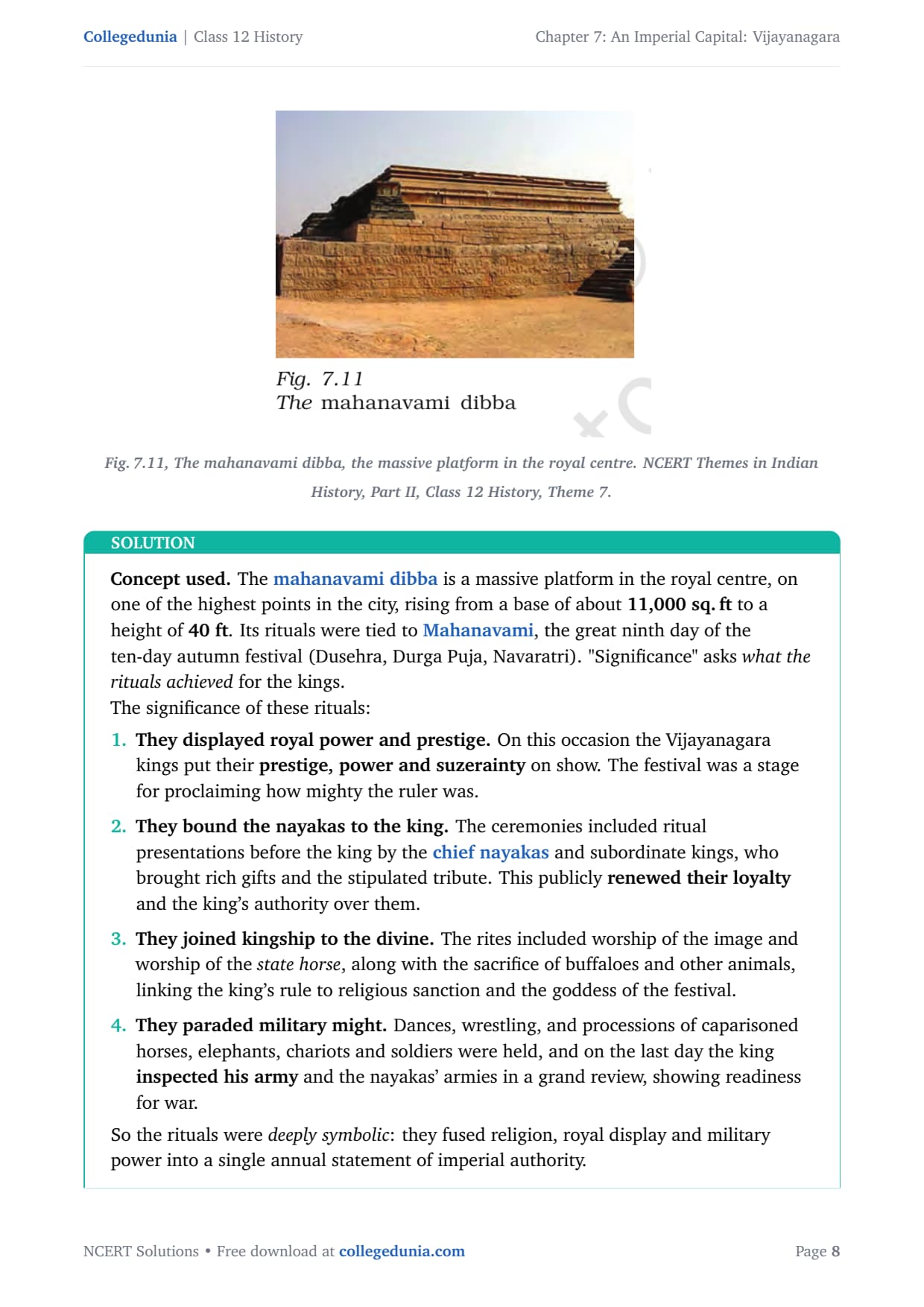
Fig. 7.11, The mahanavami dibba, the massive
platform in the royal centre. NCERT Themes in Indian History, Part II,
Class 12 History, Theme 7.
Concept used. The mahanavami dibba is a massive platform in
the royal centre, on one of the highest points in the city, rising from a base
of about 11,000 sq. ft to a height of 40 ft. Its rituals
were tied to Mahanavami, the great ninth day of the ten-day autumn
festival (Dusehra, Durga Puja, Navaratri). "Significance" asks what the
rituals achieved for the kings.
The significance of these rituals:
They displayed royal power and prestige. On this occasion the
Vijayanagara kings put their prestige, power and suzerainty on
show. The festival was a stage for proclaiming how mighty the ruler
was.
They bound the nayakas to the king. The ceremonies included
ritual presentations before the king by the chief nayakas and
subordinate kings, who brought rich gifts and the stipulated tribute.
This publicly renewed their loyalty and the king's authority
over them.
They joined kingship to the divine. The rites included worship
of the image and worship of the state horse, along with the
sacrifice of buffaloes and other animals, linking the king's rule to
religious sanction and the goddess of the festival.
They paraded military might. Dances, wrestling, and processions
of caparisoned horses, elephants, chariots and soldiers were held, and
on the last day the king inspected his army and the nayakas'
armies in a grand review, showing readiness for war.
So the rituals were deeply symbolic: they fused religion, royal display
and military power into a single annual statement of imperial authority.
Name the three layers
A full answer names all three things the festival did at once: showed royal
power, bound the nayakas through gifts and tribute, and reviewed the army.
Religion, politics and military all in one ceremony.
The mahanavami dibba rituals, held on the great ninth day of the
autumn festival, let the Vijayanagara kings display their prestige, power and
suzerainty; they bound the chief nayakas and subordinate kings through gifts
and tribute presented before the king; they tied kingship to the divine through
worship and animal sacrifice; and they paraded military strength, ending with
the king's review of the armies.
AR
Arjun Reddy
MA Medieval History, Banaras Hindu University
Verified Expert
Strategic angle. Treat "significance" as "what work did the ritual do".
Group the answer under three heads: religious sanction, political loyalty, and
military display. Three labelled functions read as analysis, not description.
Religious: worship of the image and the state horse, plus buffalo
sacrifice, on Mahanavami tied the king to the goddess and the festival,
giving his rule divine backing.
Political: the chief nayakas and subordinate kings appeared before the
king with gifts and tribute, a yearly act of submission that renewed the
whole imperial hierarchy in public view.
Military: the processions of horses, elephants, chariots and soldiers,
and the final army review, advertised the empire's fighting strength to
its own chiefs and to visitors.
Why this matters. The richest point, worth a closing line, is the
historian's caution: scholars doubt that the surviving dibba was actually the
centre of these huge ceremonies, because the space around it seems too small
for processions of armed men and large numbers of animals. Like other royal
structures, it remains an enigma. Noting that the textual
descriptions and the physical site do not fully match shows the careful,
source-critical thinking a Class 12 examiner most rewards.
The rituals fused three kinds of power into one annual event: divine
sanction (worship and sacrifice on Mahanavami), political loyalty (nayakas and
subordinate kings offering gifts and tribute before the king), and military
display (processions and an army review), all proclaiming the king's prestige
and suzerainty, though scholars doubt the surviving dibba was the actual venue.
Q 7.5
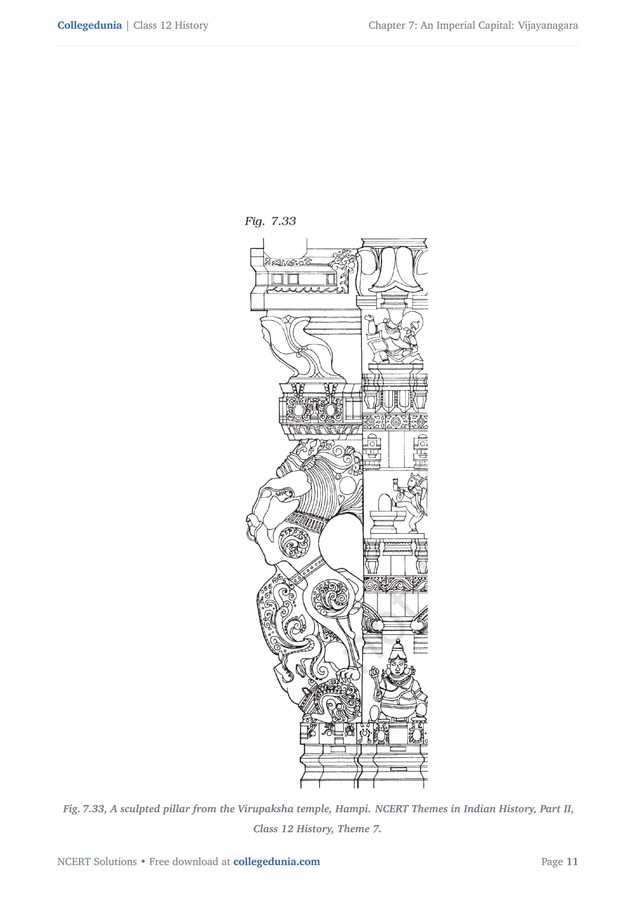
Fig. 7.33 is an illustration of another pillar from the Virupaksha
temple. Do you notice any floral motifs? What are the animals shown? Why do you
think they are depicted? Describe the human figures shown.
Fig. 7.33, A sculpted pillar from the Virupaksha
temple, Hampi. NCERT Themes in Indian History, Part II, Class 12 History,
Theme 7.
Concept used. This is a source-based (figure) question on a
carved pillar from the Virupaksha temple, whose halls Krishnadeva Raya
filled with delicately carved pillars. You answer only from what the
illustration shows, taking the four parts in turn.
Floral motifs.Yes. The pillar is covered with rich
floral and creeper motifs: scrolling leaves, lotus-like
blooms and curling foliage wind across its surface, filling the spaces
between the larger figures with decorative plant ornament.
The animals shown. The most prominent animal is a powerful
rearing yali (vyala), a mythical lion-like beast, carved
large and dominating the pillar. Smaller animals and birds are
worked into the surrounding panels and bands.
Why they are depicted. The yali was carved to signal
strength, majesty and protection: such guardian beasts were a
favourite motif on Vijayanagara temple pillars, projecting royal and
divine power and warding off evil. They also showed the skill of the
sculptors and the grandeur the rayas wished to display.
The human figures. Small human figures, including
what appear to be divine or attendant figures, are carved into
the lower and upper panels of the pillar. They stand in niches framed by
the architectural detail, dressed and ornamented, set among the animal
and floral carving as part of the sacred decorative scheme.
Answer all four prompts separately
This figure question has four clear prompts: floral motifs, animals, the reason
for them, and the human figures. Label each so you do not lose a mark by merging
them into one paragraph.
Yes, the pillar carries rich floral and creeper motifs. The main
animal is a large rearing yali (a mythical lion-like beast), with smaller
animals and birds in the panels. They are shown to project strength, majesty
and protection and to display the sculptors' skill. Small human figures,
apparently divine or attendant figures, stand in framed niches among the
carving.
SQ
Sara Qureshi
MA Art History, Aligarh Muslim University
Verified Expert
Picture-first. The marks sit on the illustration, so read it in
layers, top to bottom: decorative bands, the dominant beast, the small framed
figures. Answer the four prompts in the order the question gives them, and tie
each observation to something visible.
Floral: point to the scrolling foliage and lotus-type blooms that fill
the pillar between the figures, typical of the dense ornament on
Vijayanagara pillars.
Animal and reason together: identify the rearing yali as the
centrepiece and explain it as a guardian beast of strength and
protection, a stock motif the rayas used to broadcast power.
Human figures: describe the small deity-like or attendant figures set
in niches, ornamented and framed by architectural detail, woven into
the same scheme as the animals and flowers.
Why this matters. The wider point, worth a closing line, is what this
pillar tells us about the Virupaksha temple and its patrons. These
were the delicately carved pillars of the kind Krishnadeva Raya added to mark
his accession, so the very richness of the carving advertised the king's wealth,
piety and command over the finest sculptors. Reading a single pillar as evidence
of royal patronage, not just describing it, is the move that lifts a figure
answer into the top band.
Floral motifs: yes, scrolling foliage and lotus-like blooms. Animals:
a large rearing yali (mythical lion-beast) with smaller animals and birds,
shown to convey strength, protection and majesty and to display the carvers'
skill. Human figures: small divine or attendant figures in framed niches,
ornamented and set among the animal and floral carving.
Q 7.6
Discuss whether the term "royal centre" is an appropriate
description for the part of the city for which it is used.
Concept used. The royal centre is the name archaeologists
give to the south-western part of Vijayanagara. The essay must test whether the
name fits, by weighing what the area actually contained against what "royal"
suggests.
1. Why "royal" fits, the secular royal buildings. The area does hold
the buildings of kingship. About thirty building complexes have been
identified as palaces, large structures not tied to ritual. It
contains the so-called "king's palace" (the largest enclosure), the
court hall, and the mahanavami dibba, the platform from
which the kings displayed their power during the great autumn festival. The
Lotus Mahal and the elephant stables also stand here. These
are clearly the structures of court and state, so the label has real force.
2. Why the name is partly misleading, the many temples. Yet the royal
centre is not purely royal or secular. Although called a royal centre, it
included over 60 temples, among them the spectacular Hazara
Rama temple, probably reserved for the king and his family, with Ramayana
panels on its walls. The patronage of temples and cults was central to rulers
trying to legitimise their authority through the gods, so religion and
kingship were tangled together here.
3. The uncertainty of the names themselves. Many labels in this area
are modern guesses. The "king's palace" has yielded no definite proof of being
a royal residence; the use of the court hall is unclear; the Lotus Mahal's
purpose is unknown. The names were assigned by later observers from the form of
the buildings, not from certain evidence.
Conclusion. "Royal centre" is broadly appropriate, since the
zone clearly held the palaces, court structures and ceremonial platforms of the
rulers. But it is not a perfect description: the presence of 60-odd temples
shows the area mixed the royal and the sacred, and several of its very names
remain uncertain. The term fits the dominant character of the zone while
hiding its religious side.
The temples are the catch
The strongest point against a purely "royal" reading is the 60-plus temples
inside the centre. Use them to argue that royal power and religious patronage
were inseparable, which is why the label is appropriate but incomplete.
Largely appropriate but not perfect. The zone holds the kings'
palaces (about 30 complexes), the court hall, the mahanavami dibba, the
Lotus Mahal and the elephant stables, all genuinely royal. But it also contains
over 60 temples (including the Hazara Rama temple), showing royal and sacred
mixed together, and many of its names are modern, uncertain guesses, so the
term fits the zone's main character while hiding its religious side.
VD
Vikram Desai
MA Archaeology, University of Hyderabad
Verified Expert
Strategic angle. "Discuss whether" wants a verdict with both sides
weighed. Build it as: evidence for "royal", evidence against (the temples and
the uncertain names), then a judgement. Carry named buildings on each side so
the argument rests on facts.
For "royal": the 30 palace complexes, the king's palace, court hall
and mahanavami dibba, plus the Lotus Mahal and elephant stables, all
court and state structures, make the secular royal case.
Against a pure "royal" reading: the 60-plus temples, above all the
Hazara Rama temple meant for the royal family, show that temple
patronage was part of how the kings legitimised power, so the zone is
also sacred.
Add the source-critical twist: the labels are modern. The "king's
palace" has no proof of being a residence, the court hall's use is
unclear, so the names describe form, not certain function.
Why this matters. The mature conclusion is that the very difficulty of
naming the zone reflects a feature of Vijayanagara kingship: the rulers wove
religion into their authority, signing orders "Shri Virupaksha" and building
temples to associate themselves with the divine. So a "royal" centre full of
temples is not a contradiction but the whole point. Reaching a clear verdict,
"appropriate but incomplete", and explaining why the royal and sacred
overlap, is what earns the top band on a "discuss whether" essay.
The term is appropriate for the zone's dominant character (palaces,
court hall, mahanavami dibba, Lotus Mahal, elephant stables), but
incomplete: over 60 temples, including the royal Hazara Rama temple, show royal
and sacred mixed together, and many building names are modern, unproven guesses.
So "royal centre" fits broadly while hiding the area's religious side.
Q 7.7
What does the architecture of buildings like the Lotus Mahal and
elephant stables tell us about the rulers who commissioned them?
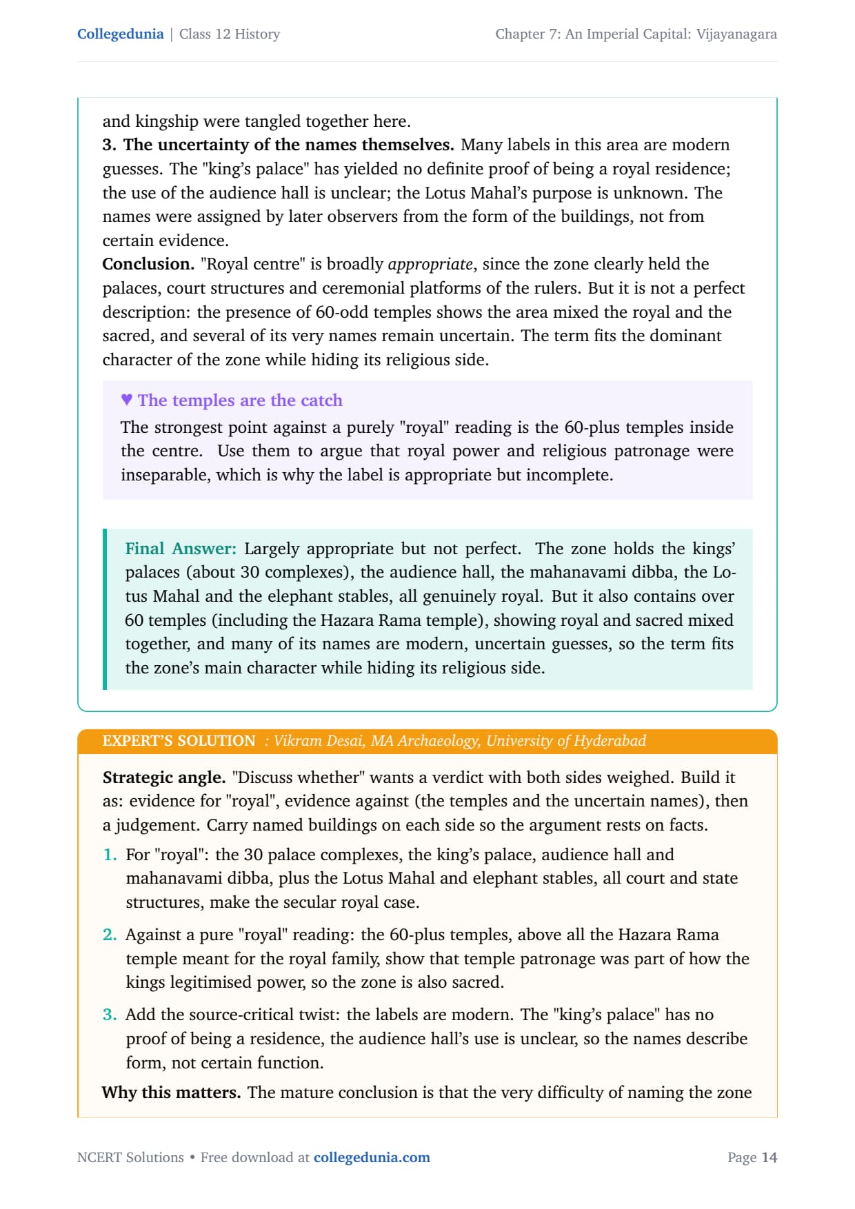
Fig. 7.15, A photograph of the Lotus Mahal,
royal centre, Vijayanagara. NCERT Themes in Indian History, Part II, Class 12
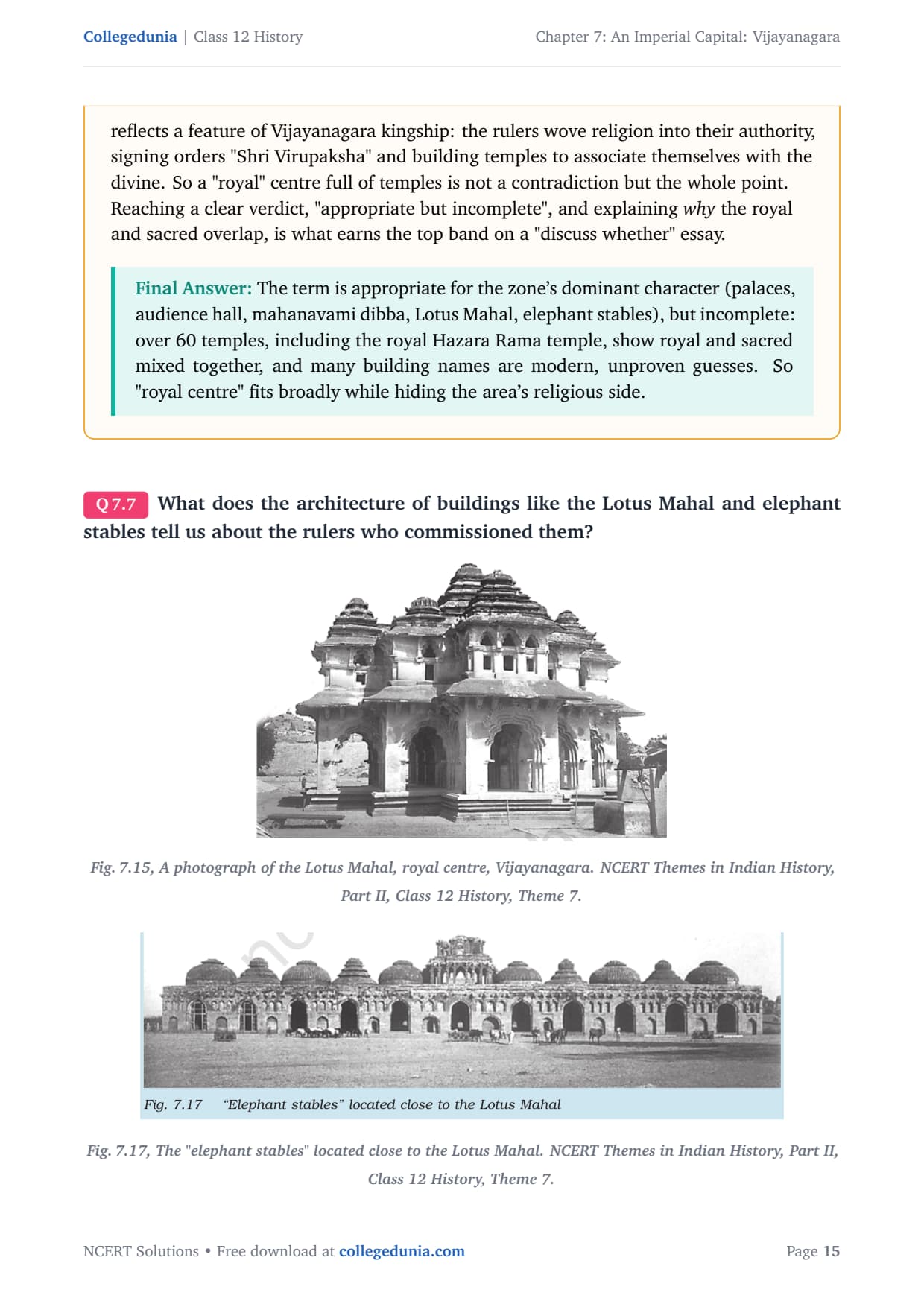
History, Theme 7.Fig. 7.17, The "elephant stables" located close
to the Lotus Mahal. NCERT Themes in Indian History, Part II, Class 12 History,
Theme 7.
Concept used. The Lotus Mahal and the elephant
stables are two famous buildings of the royal centre. Reading "what the
architecture tells us" means inferring the rulers' taste, wealth and outlook
from the style of their buildings.
The architecture tells us several things about the rulers:
They blended Hindu and Islamic styles. The Lotus Mahal's
arches and the domed, arched chambers of the elephant stables
were probably inspired by Indo-Islamic techniques, the style
introduced by the Turkish Sultans. The rulers freely borrowed
concepts and building techniques from contemporary states and
developed them further, so they were culturally open, not insular.
They were wealthy and powerful. Such refined, large structures
needed great resources, skilled architects and command over labour.
Commissioning them shows the rulers' wealth and their ability
to mobilise the techniques and craftsmen of the day.
They valued grandeur and display. The graceful Lotus Mahal
(with its nine towers, a high central one and eight around the sides)
and the imposing row of elephant stables were meant to impress,
showing rulers who cared about magnificence and the prestige of their
court.
They kept a strong military and ceremonial establishment. The
very existence of grand stables for war elephants tells us the
rulers maintained a large, prestigious army, since elephants were both
weapons of war and symbols of royal might.
Turn each feature into a statement about the ruler
Do not just describe the arches and domes. For every feature (arch, dome,
scale, stables) write one line on what it reveals: openness, wealth, love of
display, military strength.
The Indo-Islamic arches and domes of the Lotus Mahal and elephant
stables show rulers who were culturally open, blending Hindu and Islamic styles;
their scale and finish show wealth and command over skilled architects and
labour; their grandeur shows a taste for display and prestige; and the great war
-elephant stables show a powerful military establishment.
IS
Imran Sheikh
MA History, Jamia Millia Islamia
Verified Expert
Structural observation. The question is really "infer the patron from
the building". Make each architectural fact yield a conclusion about the ruler:
style to openness, scale to wealth, ornament to display, stables to military
power. Four facts, four inferences.
Style: the arches and domes are Indo-Islamic, the Sultans' style
adopted and adapted, so the rulers were confident borrowers who made a
composite imperial culture rather than rejecting outside influence.
Scale and craft: building such large, refined structures proves wealth
and the ability to command the best architects, masons and resources of
the region.
Function: the elephant stables show a large standing force of war
elephants, while the Lotus Mahal, perhaps a council chamber, shows a
settled, ceremonious court life.
Why this matters. The deeper argument is that these buildings are
political statements in stone. By adopting Indo-Islamic features while
ruling a Hindu kingdom, the rayas signalled a cosmopolitan, self-confident
authority, the same impulse that made Krishnadeva Raya take the title
"establisher of the Yavana kingdom" and the kings style themselves "Hindu
Suratrana" (Hindu Sultan). Showing that architecture broadcasts the rulers'
self-image, not just their taste, is the historian's reading the examiner
wants.
The Lotus Mahal and elephant stables reveal rulers who were
culturally open (Indo-Islamic arches and domes blended into a Hindu kingdom),
wealthy and able to command skilled architects, fond of grandeur and display,
and militarily strong (the great war-elephant stables). Their architecture was a
deliberate statement of cosmopolitan imperial power.
Q 7.8
What are the architectural traditions that inspired the architects of
Vijayanagara? How did they transform these traditions?
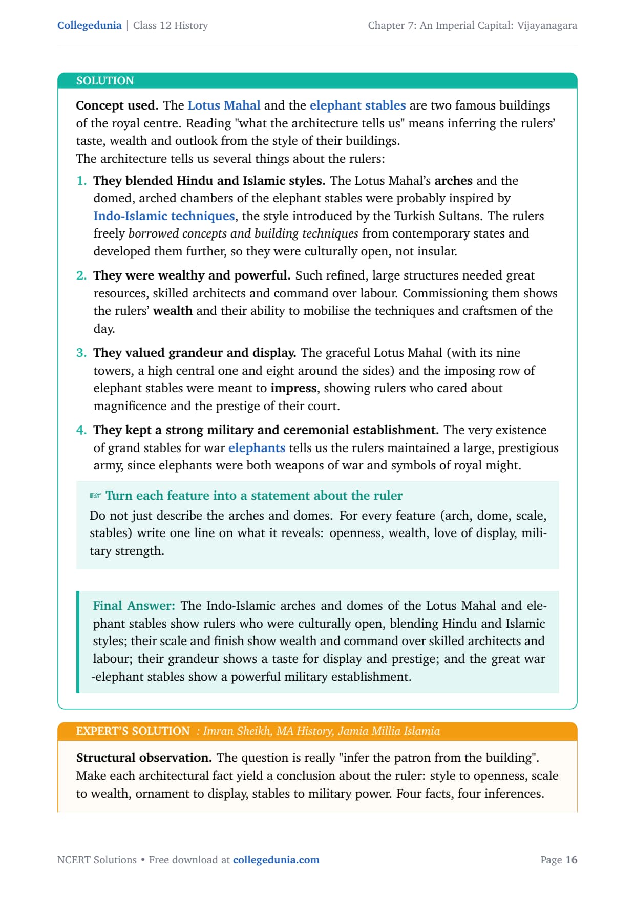
Fig. 7.24, The chariot of the Vitthala temple,
sacred centre, Vijayanagara. NCERT Themes in Indian History, Part II, Class 12
History, Theme 7.
Concept used. An architectural tradition is an inherited
style of building. The essay has two halves: name the traditions the
Vijayanagara architects inherited, then show how they transformed
(changed and developed) them.
1. The temple-building traditions of the south. Temple building in the
region had a long history going back to the Pallavas, Chalukyas,
Hoysalas and Cholas. Earlier ruling elites had patronised elaborate temples
such as the Brihadishvara temple at Thanjavur (Cholas) and the
Chennakeshava temple at Belur (Hoysalas). The rayas built on these
traditions.
2. The Indo-Islamic tradition. Through interaction with the Sultans of
the Deccan, the architects also drew on Indo-Islamic techniques, the
arches and domes introduced by the Turkish Sultans, which appear on the
fortification gateways, the Lotus Mahal and the elephant stables.
How they transformed these traditions:
They built on a colossal new scale. The rayas carried the
southern temple tradition "literally to new heights" by raising
raya gopurams, royal gateway-towers so immense that they
dwarfed the towers over the central shrines and announced the
temple from a great distance, marking imperial authority.
They added grand mandapas and corridors. They built large
pillared mandapas (pavilions) and long pillared corridors
running around the shrines, with delicately carved pillars, as in the
hall Krishnadeva Raya added to the Virupaksha temple.
They invented striking new forms. The Vitthala
temple has a unique shrine designed as a stone chariot, and
chariot streets paved with stone slabs and lined with pillared
pavilions ran straight out from the temple gopurams.
They drew deities and styles together. They introduced the
worship of Vitthala, a form of Vishnu from Maharashtra, into
Karnataka, and folded Indo-Islamic arches into their buildings, creating
a composite imperial culture.
The raya gopuram is the signature
The clearest sign of transformation is the raya gopuram, gateways taller than
the shrine-towers themselves. Cite it as proof that the rayas scaled up the
inherited tradition into a statement of empire.
The architects inherited the southern temple traditions of the
Pallavas, Chalukyas, Hoysalas and Cholas (such as the Brihadishvara temple) and
the Indo-Islamic arches and domes of the Deccan Sultans. They transformed these
by building on a colossal scale (the towering raya gopurams that dwarfed the
shrine towers), adding grand pillared mandapas and corridors, inventing forms
like the Vitthala temple's stone chariot and chariot streets, and blending
borrowed deities and styles into one imperial culture.
TJ
Tara Joshi
MA Art History, Visva-Bharati University
Verified Expert
Structural observation. Two-part question, so two clear blocks: the
inherited traditions, then the transformations. List the source dynasties for
the first; give concrete new features (gopuram, mandapa, chariot shrine) for the
second. Examples carry this essay.
Inherited: name the Pallavas, Chalukyas, Hoysalas and Cholas for the
temple tradition, with the Brihadishvara temple as the model, and the
Deccan Sultans for the Indo-Islamic arch and dome.
Transformed, scale: the raya gopurams, gateway-towers so tall they
dwarfed the central shrines, are the headline change, monumental size as
a mark of imperial power.
Transformed, form: pillared mandapas and corridors, the chariot-shaped
Vitthala shrine, chariot streets, and the import of the Maharashtrian
god Vitthala, all show invention layered onto inheritance.
Why this matters. The deeper argument is that the rayas used
architecture to forge an imperial culture out of many regional and
religious strands, southern temple forms, a Maharashtrian deity and
Indo-Islamic techniques fused in one capital. The towering gopurams were also
reminders of a king able to command the resources, skills and labour to raise
them. Showing that the "transformation" was not just bigger buildings but a
deliberate gathering of traditions into an imperial style is the top-band
insight.
Inherited: the southern temple traditions of the Pallavas, Chalukyas,
Hoysalas and Cholas (e.g. the Brihadishvara temple) and the Indo-Islamic arches
and domes of the Deccan Sultans. Transformed: by monumental scale (raya
gopurams dwarfing the shrine towers), grand pillared mandapas and corridors,
inventive forms like the Vitthala stone chariot and chariot streets, and the
fusion of borrowed deities and styles into a single imperial culture.
Q 7.9
What impression of the lives of the ordinary people of Vijayanagara
can you cull from the various descriptions in the chapter?
Concept used. "Ordinary people" means the common town dwellers,
traders, craftspeople and others, not the kings or nobles. The evidence is
thin, since their houses have not survived, so you "cull" the impression from
travellers' accounts, field surveys and archaeology.
The impression that emerges:
They lived in modest, well-arranged homes. The houses of
ordinary people have not survived, but the Portuguese traveller
Barbosa described them as thatched, "but nonetheless
well built and arranged according to occupations, in long streets with
many open places". So homes were humble but the town was orderly, laid
out by trade.
They worked in many trades and a busy market. The city had
markets dealing in spices, textiles and precious stones. Paes called it
"the best-provided city in the world", with streets of merchants
selling rubies, diamonds, pearls and cloth, and fairs selling horses,
fruit and vegetables. Nuniz listed abundant, cheap food, rice, wheat,
pulses, many fruits and meats. Ordinary life was thus tied to a thriving
commercial world.
They followed a variety of cults. Field surveys show the urban
area dotted with numerous shrines and small temples, pointing
to many cults supported by different communities. Religion was woven
into everyday life.
They drew water from local sources. Wells, rainwater tanks and
temple tanks served ordinary town dwellers as sources of water.
Some were prosperous, and the city was diverse. Fine Chinese
porcelain in the north-eastern urban core suggests rich traders lived
there, which was also the Muslim residential quarter with its tombs and
mosques, so the population was wealthy in parts and culturally mixed.
Read the silence of the ruins
The houses of ordinary people vanished because they were built of perishable
materials, while temples and palaces of stone survived. So the impression of
common life rests heavily on travellers' words, a reminder to read the gaps in
the evidence.
Ordinary people lived in modest, thatched but well-built homes in long
streets arranged by occupation (Barbosa); they worked in busy markets that
travellers called the best-provided in the world, with abundant cheap food and
rich goods (Paes, Nuniz); they followed many local cults at numerous small
shrines; they drew water from wells and tanks; and the city was diverse and
prosperous in parts, with rich traders and a Muslim quarter.
NV
Nikhil Verma
MA History, MS University of Baroda
Verified Expert
Strategic angle. Organise the "impression" around themes, housing,
work and market, religion, water, diversity, and attach each to a named source.
The examiner rewards an answer built from the chapter's evidence, not vague
generalisation.
Housing and order: Barbosa's thatched houses "arranged according to
occupations, in long streets" gives both the modesty and the
orderliness of ordinary life.
Work and plenty: Paes ("best-provided city in the world") and Nuniz
(markets overflowing with cheap fruit, grain and meat) show a busy,
well-fed commercial population.
Belief and supply: the many small shrines from field surveys, and the
wells and temple tanks, fill in religion and daily water; the Chinese
porcelain and Muslim quarter add wealth and diversity.
Why this matters. The mature point is about the limits of the
evidence: because the common people's perishable houses did not survive, the
historian must reconstruct their lives mostly from outsiders' accounts and the
faint traces of archaeology (porcelain shards, pillar bases, shrines). Saying
clearly that the impression is real but partial, drawn from travellers and
survey rather than from the people's own voices, shows the source-awareness
that lifts the answer.
From travellers and surveys we get a city of modest but orderly
thatched homes grouped by occupation (Barbosa), a busy, well-supplied
commercial life with cheap, abundant goods (Paes, Nuniz), many small shrines and
cults, water from wells and tanks, and pockets of wealth and a Muslim quarter,
though the impression is partial since ordinary people's houses did not
survive.
Q 7.10
On an outline map of the world, mark approximately Italy, Portugal,
Iran and Russia. Trace the routes the travellers mentioned on p.176 would have
taken to reach Vijayanagara.
Concept used. This is a map-work task. You mark the four home
countries of the foreign travellers who visited Vijayanagara, and trace the
land and sea routes they would have taken to reach the city in the
Deccan. Below is the guide; on your own outline world map, mark each country and
draw arrows for the routes.
Mark the four countries (and the travellers).
Italy, home of Nicolo de Conti, the Italian
trader (fifteenth century).
Portugal, home of Duarte Barbosa, Domingo Paes
and Fernao Nuniz (sixteenth century).
Iran (Persia), from where Abdur Razzaq was sent
as an ambassador (fifteenth century).
Russia, home of the merchant Afanasii Nikitin
(fifteenth century).
Mark Vijayanagara in the Deccan of southern India as the
destination.
Trace the routes (draw arrows). The Europeans (from Italy,
Portugal and Russia) would travel largely by sea: from the
Mediterranean and Atlantic, around or across to the Arabian Sea, landing
on India's west coast (such as Calicut or Goa) and travelling inland to
Vijayanagara. The Portuguese, after 1498, came by the long sea route
around Africa. The Persian envoy Abdur Razzaq travelled from
Iran across the Arabian Sea to Calicut and then inland.
Distinguish sea from land legs
Use one kind of arrow for the long sea voyage and another for the short inland
land leg from the west-coast port to Vijayanagara, and add a small key. Markers
look for the two told apart.
Mark Italy (Nicolo de Conti), Portugal (Barbosa, Paes, Nuniz), Iran
(Abdur Razzaq) and Russia (Afanasii Nikitin), and Vijayanagara in the southern
Deccan. Trace mainly sea routes across the Mediterranean/Atlantic and Arabian
Sea to India's west-coast ports (Calicut, Goa), then short land routes inland to
Vijayanagara, with a key separating sea from land.
PB
Pooja Bhatt
MA Historical Geography, Aligarh Muslim University
Verified Expert
Structural observation. Map work scores on accuracy and legibility.
Plan it in three moves: mark the four countries plus Vijayanagara, draw the
sea-then-land routes, add a key. Neat, correctly placed marks score full;
crowded scribbles do not.
Place the four countries correctly: Italy and Portugal in southern and
western Europe, Russia to the north-east of Europe, Iran in West Asia,
then Vijayanagara in the southern Deccan.
Draw the routes as mostly sea voyages converging on India's west coast
(Calicut, Goa), with the Portuguese taking the long way around Africa
after 1498 and Abdur Razzaq crossing the Arabian Sea from Persia.
Finish each route with a short inland land arrow to Vijayanagara, and
add a clear key in a corner of the map.
Why this matters. The task turns the chapter's list of foreign
travellers into geography, showing that Vijayanagara was famous enough to draw
visitors from Italy, Portugal, Persia and Russia. A clean world map with the
four countries, the converging sea routes and a key is the whole answer.
Mark Italy, Portugal, Iran and Russia, and Vijayanagara in the Deccan;
draw mostly sea routes across the Mediterranean/Atlantic and Arabian Sea to
west-coast ports (Calicut, Goa), with the Portuguese rounding Africa after 1498,
then short land routes inland, all explained by a key.
Q 7.11
Find out more about any one of the major cities which flourished in
the subcontinent during c. fourteenth-seventeenth centuries. Describe the
architecture of the city. Are there any features to suggest that these were
political centres? Are there buildings that were ritually significant? Is there
an area for commercial activities? What are the features that distinguish the
urban layout from that of surrounding areas?
Concept used. This is a project (city study). You pick one
major city of c. 1300–1700 (for example Delhi, Agra, Fatehpur Sikri, Bidar,
Golconda or Madurai) and study it the way the chapter studies Vijayanagara,
under set heads. There is no single right answer; you are marked on how well you
gather and organise the evidence.
Choose a city and describe its architecture. Pick one flourishing
city of the period and describe its main buildings, their materials,
forms (arches, domes, towers, courtyards), and styles, noting any blend
of traditions as at Vijayanagara.
Look for signs of a political centre. Search for forts,
palaces, court halls or administrative buildings, the kind of
secular royal structures that marked Vijayanagara's royal centre, as
evidence the city was a seat of power.
Look for ritually significant buildings. Note temples,
mosques, tombs or other places of worship, like Vijayanagara's sacred
centre with its Virupaksha and Vitthala temples, and say how they were
used.
Find the commercial area. Look for bazaars, market
streets and trading quarters, like the chariot streets and bazaars of
Vijayanagara, where merchants set up shops.
Compare the urban layout with its surroundings. Note what makes
the city stand out from the countryside around it: walls and gateways,
planned streets, water works, dense buildings, the same distinctive
layout that set Vijayanagara apart.
Use the chapter's own headings
Borrow Vijayanagara's structure, political (royal) centre, sacred centre,
commercial area, water and walls, as the headings for your chosen city. It keeps
the report organised and invites easy comparison.
Pick one major city of c. 1300–1700, describe its architecture, then
report under four heads: signs of a political centre (forts, palaces, court
halls), ritually significant buildings (temples, mosques, tombs), a commercial
area (bazaars and market streets), and the layout features (walls, planned
streets, waterworks) that distinguish the city from its surroundings, comparing
each with Vijayanagara.
AR
Aditi Rao
MA Urban History, University of Hyderabad
Verified Expert
Strategic angle. Treat the five prompts as five sections of a report,
and mirror Vijayanagara at every step so the comparison does the analytical
work. Choose a city with good evidence (Fatehpur Sikri, Golconda or Madurai work
well) so you can fill each section.
Open with the city and a short architectural overview, naming its signature
buildings and the materials and styles used.
Take the four prompts as headed subsections, political, ritual,
commercial, and layout-versus-surroundings, and put one concrete
example under each.
Close by comparing your city with Vijayanagara: where it too separated a
royal zone, a sacred zone and a market, and where it differed.
Why this matters. The project teaches the chapter's real method, that a
city's plan and buildings reveal its power, faith and trade, by making you apply
to a new city the very questions historians asked of Vijayanagara.
Choose one major city of the period, give an architectural overview,
then report under headed sections, political buildings (forts, palaces), ritual
buildings (temples, mosques, tombs), commercial areas (bazaars), and the layout
that sets the city apart (walls, planned streets, water), closing with a direct
comparison to Vijayanagara.
Q 7.12
Visit a religious building in your neighbourhood. Describe, with
sketches, its roof, pillars and arches if any, corridors, passages, halls,
entrance, water supply, etc. Compare these features with those of the Virupaksha
temple. Describe what each part of the building is used for. Find out about its
history.
Concept used. This is a project (field observation). You
visit a real religious building near you, record its parts with sketches, and
compare them with the Virupaksha temple of Vijayanagara. There is no
fixed answer; you are marked on careful observation and clear comparison.
Sketch and describe the structure. Visit a temple, mosque,
church or gurudwara nearby and sketch its roof, pillars and
arches, corridors and passages, halls, entrance and water supply. Note
the materials and shapes of each.
Say what each part is used for. For every feature, write its
function: the entrance (and any gateway tower) for access, the hall for
gatherings or worship, the central shrine for the deity, corridors for
circulation or processions, the water supply for ritual use, just as the
Virupaksha temple's halls were used for music, dance, divine marriages
and swinging the deities.
Compare with the Virupaksha temple. Match each feature to
Virupaksha: does your building have a tall gateway like a
gopuram? Pillared halls like its mandapas? A central
shrine like its small garbhagriha? A tank like its temple
tank? Note the similarities and differences.
Find out its history. Ask the caretakers or read about the
building: when it was built, by whom, and how it has changed, recalling
how the Virupaksha temple was built over centuries and enlarged under
Krishnadeva Raya.
The marks are in the comparison
The report is not just a description of a local building; the marks come from
comparing each of its parts with the Virupaksha temple. For every feature
you sketch, add a line on how it is like or unlike that temple.
Visit a religious building nearby, sketch and describe its roof,
pillars, arches, corridors, halls, entrance and water supply, and state the use
of each part. Compare every feature with the Virupaksha temple (gopuram,
mandapas, central shrine, temple tank), and find out the building's history
(date, patron, later changes), as the Virupaksha temple grew over centuries and
under Krishnadeva Raya.
KA
Kabir Anand
MA History, Jadavpur University
Verified Expert
Strategic angle. Build the report as a two-column comparison, "my
building" against "Virupaksha temple", feature by feature. The sketches go in
the first column, the chapter facts in the second, and the marks come from the
matching.
Visit once and record everything first-hand: sketch the roof, pillars,
arches, halls, entrance and water supply, labelling each part.
For each labelled part, write its use and then its Virupaksha
equivalent, gateway to gopuram, hall to mandapa, shrine to garbhagriha,
tank to temple tank.
Add a short history section (date, patron, changes) and a conclusion on
what your building shares with, and how it differs from, the Vijayanagara
temple.
Why this matters. The project makes you read a living building the way
the chapter reads Vijayanagara: as a set of meaningful, used spaces with a
history of patronage and change. Doing the comparison part by part, rather than
describing in the abstract, is exactly the skill being marked.
Visit and sketch a nearby religious building's roof, pillars, arches,
corridors, halls, entrance and water supply, state each part's use, and compare
them feature by feature with the Virupaksha temple (gopuram, mandapas, shrine,
tank), adding the building's history of construction and change.
FAQs on An Imperial Capital Vijayanagara Class 12 NCERT Solutions
An Imperial Capital Vijayanagara Class 12 History Common Questions
Ques. Where can I get the class 12 history chapter 7 ncert solutions PDF?
Ans. You can download the An Imperial Capital Vijayanagara Class 12 History NCERT Solutions PDF directly from this page. It is free, follows the 2026-27 NCERT, and answers all 12 exercise questions step by step.
Ques. How many questions are there in class 12 history chapter 7 questions and answers?
Ans. The chapter has 12 exercise questions. Nine are written answers, and the last three (7.10 to 7.12) are map work and project activities used in the history project file class 12 chapter 7.
Ques. Which are the most important questions in history class 12 chapter 7 question answer practice?
Ans. The significance of the mahanavami dibba rituals (Q 7.4), whether "royal centre" is an apt name (Q 7.6), and the architectural traditions of Vijayanagara (Q 7.8) are the most-asked long answers. These three top every list of class 12 history chapter 7 important questions.
Ques. Who founded the Vijayanagara Empire and when did it fall?
Ans. The brothers Harihara and Bukka founded the empire in 1336. After four dynasties and its peak under Krishnadeva Raya, it fell in 1565 at the battle of Talikota, when an alliance of the Deccan Sultanates sacked the capital.
Ques. How were the water needs of Vijayanagara met?
Ans. The city used the Tungabhadra basin and its hill streams. Embankments dammed the streams into reservoirs, the Kamalapuram tank stored water, and the Hiriya canal carried water to the fields. Wells served ordinary homes.
Ques. Is class 12 history chapter 7 hard to score in the board exam?
Ans. No. It is one of the easier scoring chapters if you keep the city's three zones straight and learn the key dates and rulers. Practise the source-based extracts and a few class 12 history chapter 7 mcq sets, and keep the mahanavami dibba and temple architecture ready in your own words.









Comments