



Education Journalist | Study Abroad Lead
GPS or Global Positioning System is a satellite-based radio navigation system that is used on the land, sea, and air to determine location, time, and velocity irrespective of weather conditions. It was earlier known as NAVSTAR GPS (Navigation Satellite Timing and Ranging System GPS). This is the GPS of the US which consists of a set of 24 satellites revolving in 6 orbits around the earth in a span of just 12 hours. The Russian Constellation GLONASS (Global Navigation Satellite System) is another classic example of the GPS that has enabled an individual to know his own location and find out easier routes of commuting. The major components of the global positioning system are the Satellites, ground stations, and a receiver.
Also Read: Satellite Communication
| Table of Content |
Key Terms: GPS, GPS Components, Satellite, Ground Stations, Receivers, Trilateration, Accuracy, Navigation, Tracking, Radio Signals
What is GPS?
[Click Here for Sample Questions]
A Global Positioning System, GPS is the fastest navigation methodology that employs certain algorithms in addition to the satellites and a receiver. Let us look at some of the features of the GPS:
- GPS is an aggregation of satellites that orbit the earth like a constellation of stars.
- The positions of the satellite constellations can constantly be tracked from the earth.
- This network of satellites constantly sends coded information in the form of radio signals.
- This satellite system is composed of 31 satellites situated almost 20,000 km above the earth’s surface.
- GPS is used on land, sea, and air to determine location, time, and velocity irrespective of weather conditions.
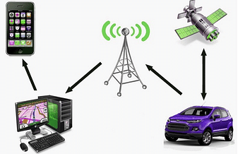
Tracking Using GPS
The video below explains this:
Global Positioning System Detailed Video Explanation:
Read More:
| Important Topics Related to Global Positioning System | ||
|---|---|---|
| Gravitation | Gravitational Potential Energy | Escape Speed |
| Weightlessness | Mass and Weight | Thrust and Pressure |
| Sky Wave Propagation | Remote Sensing | Need for Modulation |
GPS Components
[Click Here for Previous Year Questions]
A GPS system consists of three components that work as a single unit to provide the necessary data. They are:
- Staellites- Space Component
- Ground Stations- Control Component
- Receivers- User Component
Satellites
The space component of GPS comprises the satellites that orbit the earth at an altitude of 20,000 km above the earth's surface for a period of 12 hours. Some key features of satellites are:
- Their orbits are designed in a way such that 6 satellites are always within a line of sight from any location on the earth.
- At least 4 Satellites are available for observations throughout the year at any time anywhere in the world.
- Satellites act like stars in the constellations whose locations are known as they send out signals.

Earth Satellites
Also Read: Moon - The Natural Satellite
Ground Stations
The control component are the ground stations which further comprise of three sub-components:
- Master Control System
- Monitor Station
- Ground Antenna
The key functions of the ground stations include:
- Checking the movement and proper functioning of the satellites.
- Using radar to make sure of the position of the satellites.

Goldstone Deep Space Communications Complex, California
Also Read: Ground Wave Propagation
Receivers
The user Segment comprises the GPS receiver. GPS receivers are present in smartphones, tablets, pcs, etc. which receive GPS signals and determine their location from the satellite. Some key features include:
- Estimating the distance of the satellites
- Once the receiver calculates its distance from the four or more satellites, it exactly determines your location.

Components of GPS
Trilateration
[Click Here for Sample Questions]
The GPS works on the mathematical principle of trilateration. Let us understand trilateration in detail.
- Trilateration is a process used to determine the location based on the intersection of the spheres.
- The distance between the satellite and the receiver is calculated by considering a 3-D sphere where the satellite is located at the center of the sphere.
- Using the same method, the distance from all three GPS satellites to the receiver is calculated and the exact location of the receiver is found.
Working
To understand this process we take the help of a 2-D example. Suppose we have three satellites within the line of sight of a GPS receiver. Each satellite broadcasts a signal for the GPS receiver to pick up at a specific time and distance.
- The first satellite broadcasts a radio signal that eventually hits the GPS receiver.
- From this, the distance of the receiver from the satellite is measured. Now, this distance forms a circle around the satellite in all directions.
- The position of the receiver could possibly be anywhere on the circumference of any of these circles.

Figure 1
- Next, the 2nd satellite sends a signal to the receiver, forming another circle of the same calculated distance around this satellite in all directions.
- Two distances are known from two satellites. With the two signals, the precise position could be any of the given two points where the circles intersect.

Figure 2
- The same procedure is followed by the 3rd satellite, but this time the third circle intersects with any of the two intersections mentioned above.

Figure 3
- This point at which all the three circles intersect is the actual location of the receiver.

Three-Dimensional Representation of Trilateration
Uses of GPS
[Click Here for Previous Year Questions]
Some of the important uses of a GPS are listed below:
- Location: To find the exact location of any object.
- Navigation: To assist in navigation while moving from one place to another.
- Tracking: To track the movement of any object.
- Mapping: To create maps of any place or part of the whole world.
- Timing: To take precise time measurements.
- Disaster Management: GPS plays a vital role in emergency response systems.
- Construction & Planning: It is widely used in the urban planning and development sector.
- Defence: It is also used in the defense sector for accurate target and attack operations.
- Entertainment: Games and activities are based out of GPS.
- Health and Fitness: Wearable technologies like smart watches or samrt bands produce real-time data.
- Transportation: Used by logistic companies in telematic systems.
Also Read: Mapping Space Around Us
GPS Accuracy
[Click Here for Sample Questions]
The accuracy of the global positioning system relies on multiple factors such as the nature of the inosphere, number of satellites and the urban atmosphere. The following are some of the hindrances in the proper functioning of the GPS:
- Atmospheric Effects: Atmospheric storms can cause isnosphere delays affeting the real time data collection of the GPS.
- Ephimeris: Outadated version of the orbital model within the satellite.
- Physical Obstructions: Large structures like mountains or buildings can cause delay in arrival time measurements.
- Numerical Errors: Device hardware does not meed needed specifications.
- Artificial Interference: Use of jamming devices to block the signals.
Things to Remember
- GPS is a radio navigation system based on satellites and is used across different topography to determine location, time, and movement.
- GPS has three components- the space segment, the control segment, and the user segment.
- GPS works on the Principle of Trilateration to determine the exact location of the receiver.
- GPS is used for location, navigation, tracking, mapping, and time measurements.
- The GPS system has made it easier to track the location of any object, person, or vehicle and determine its exact location.
Read More:
Previous Year Questions
- Question on Geostationary satellite. [BITSAT 2008]
- Find the ratio of escape velocity. [BITSAT 2010]
- Find the speed of the article under gravitation. [VITEEE 2013]
- Find the distance of a given point from moon. [JCECE 2007]
- Calculate the percentage energy needed to shift the satellite. [JKCET 2015]
- Which curve represents total energy variation of satellite. [AMUEEE 2014]
- Relation of the period with the density of an artificial satellite. [JIPMER]
- Determine the relative velocity of approach. [APEAPCET]
- Calculate the new time period of the satellite. [BITSAT 2019]
- Calculate the work done to take a point from A to B. [BITSAT 2013]
- If Earth shrinks, the new day duration is? [APEAPCET]
- The g value for a planet boigger than the earth is? [NEET 2005]
- Calculate the speed of four particles of identical sizes. [JEE Main 2021]
- The ratio of kinetic to potential energy for a moving satellite is? [NEET 2005]
- Calculate the value of g at a height from the earth’ surface. [JKCET 2004]
- Calculate g at a point below the earth’s surface. [APEAPCET]
- Choose the correct for a synchronous relay satellite. [BHU UET]
- What is g at a height half the radius of the earth. [NEET 2020]
- Determine the escape velocity. [NEET 1993]
- Determine the ratio of the time periods. [NEET 1993]
- When satellite is launched at an angle, the escape velocity is. [NEET 1989]
- Determine the relation between G and K. [NEET 2015]
Sample Questions
Ques. What is the full form of GPS? On what principle does a GPS work? (3 Marks)
Ans. The full form of GPS is Global Positioning System. It is a radio-based navigation system that is used on land, sea and air to determine location, time and velocity irrespective of weather conditions.
A GPS works on the mathematical system of Trilateration that is used to determine the location based on the intersection of the spheres.
Ques. What are the uses of GPS? (3 Marks)
Ans. The uses of a GPS are as follows:
- It is used for navigation, to help people to move from one place to another helping them to find the easiest and most convenient route to reach their destination.
- The GPS system has made it easier to track the location of any object, person or vehicle and determine their exact location.
- It helps to make more exact and clear maps, whether it is of a small place or a country.
Ques. Name the parameters that can be calculated by trilateration. (3 Marks)
Ans. The parameters that can be calculated using the trilateration method are:
- Time of sunrise
- Time of sunset
- Distance between the GPS receiver and the satellite
Ques. How many satellites are needed at the line of sight of a receiver to locate its position? (3 Marks)
Ans. For a receiver to locate its position at least three satellites should be present at the line of sight of the receiver. The satellites in the GPS constellation are so arranged and placed that about three satellites are always above any place on the earth. This is how the system covers the entire space on Earth and can access the location of any object on Earth.
Ques. What is the function of the control segment of GPS? (3 Marks)
Ans. The control component consists of three sub-components:
- Master Control System
- Monitor Station
- Ground Antenna
All these sub-components together check the movement and proper functioning of the satellites in their respective orbits.
Ques. How many satellites are there in the GPS constellation? (2 Marks)
Ans. About 31 satellites are there in the GPS constellation. This network of satellites constantly sends coded information in the form of radio signals. This satellite system is situated almost 20,000 km above the earth’s surface.
Ques. What equipments are used on the satellites to help them find accurate time information? (3 Marks)
Ans. Multiple Atomic clocks are present on the satellites that help to find accurate time information. In an atomic clock, the natural oscillations of atoms act as the pendulum does in a grandfather clock. However, atomic clocks are far more precise than conventional clocks because atomic oscillations have a much higher frequency and are much more stable.
Ques. Name the regional GPS used by the Indians. (3 Marks)
Ans. NaviC is the regional GPS used by the Indians. It is also called IRNSS (Indian Regional Navigation Satellite System). It is an independent regional navigation satellite system that is developed by India. It is designed to provide accurate position information service to users in India as well as the region extending up to 1500 km from our boundary.
Check Out:



Comments