




CBSE Class 12 Geography Set 1 - (64/1/1) Question Paper 2026 is available for download here. CBSE conducted class 12 Geography exam on February 26, 2026 from 10:30 AM to 1:30 PM.
Geography question paper includes 70 marks of theory paper and 30 marks of practical work, combining conceptual knowledge with fieldwork, map skills, and data interpretation. 35 marks are allotted to Fundamentals of Human Geography, 35 marks to India: People and Economy, and 30 marks to Practical Work in Geography - Part II.
You can download CBSE Class 12 Geography Set 1 - (64/1/1) Question Paper 2026 with Solutions from the links provided below.
CBSE Class 12 Geography Set 1 - (64/1/1) Question Paper 2026 with Solution PDF
| CBSE 2026 Class 12 Geography Set 1 - (64/1/1) Question Paper 2026 | Download PDF | Check Solutions |






Which of the following statements related to the concept of ‘development’ are correct ? Choose the appropriate option.
I. Development means positive change in life.
II. When positive growth is there, it is development.
III. When quantity is greater, it is development.
IV. Development is always relative to value.
Detailed Solution
Concept:
Development refers to a qualitative change that is always value positive.
This means development cannot take place unless there is an increment or addition to the existing conditions.
Growth is quantitative and value neutral.
It may be positive or negative.
Step 1: Analyze statements I and II.
Development always means a positive change in the quality of life.
Positive growth does not always lead to development, but development occurs when there is positive growth that improves quality.
Hence, I and II are correct.
Step 2: Analyze statements III and IV.
Statement III says greater quantity is development, but simple quantitative growth without qualitative improvement is not development.
Statement IV is correct because development is always relative to the positive values it brings to human life.
Therefore, statements I, II, and IV are correct. Quick Tip: Remember the formula: Positive Growth + Qualitative Change = Development.
Growth can be negative, but Development is always positive.
Match column-I with column-II correctly and choose the appropriate option :

Detailed Solution
Concept:
There are four main approaches to human development: Income, Welfare, Basic Needs, and Capability.
Each approach has a distinct focus on how to define and achieve human progress.
Step 1: Match Income and Welfare approaches.
The Income approach is one of the oldest approaches, where human development is linked to income (a-iii).
The Welfare approach looks at human beings as beneficiaries and focuses on government expenditure (b-iv).
Step 2: Match Basic Needs and Capability approaches.
The Basic Needs approach was proposed by the ILO and identifies six basic needs (c-i).
The Capability approach, associated with Prof. Amartya Sen, focuses on building human capabilities (d-ii).
The correct sequence is (D). Quick Tip: Keywords: Oldest = Income.
ILO = Basic Needs.
Beneficiaries = Welfare.
Capabilities = Capability Approach.
Which one of the following is the low latitudes zone of subsistence gathering practiced in the world ?
Detailed Solution
Concept:
Gathering is practiced in regions with very harsh climatic conditions.
It is carried out in high latitude zones and low latitude zones.
Step 1: Identify high latitude gathering zones.
High latitude zones include Northern Canada, Northern Eurasia, and Southern Chile.
Step 2: Identify low latitude gathering zones.
Low latitude zones include the Amazon Basin, Tropical Africa, and Southeast Asia.
Since the question asks for the low latitude zone, Southeast Asia is the correct answer. Quick Tip: Low latitude usually refers to the tropical belt (between the Tropics of Cancer and Capricorn).
High latitude refers to the Arctic or Sub-Antarctic regions.
Choose the correct option related to oil tanker ports of the world.
Detailed Solution
Concept:
Ports are classified based on their specialized functions.
Oil ports handle the processing and shipping of oil.
Step 1: Evaluate the locations.
Maracaibo in Venezuela is a major oil port.
Esskhira in Tunisia and Tripoli in Lebanon are also significant oil terminals.
Step 2: Eliminate incorrect options.
Singapore is an entrepot port.
Manchester is a river port.
Marmagao is an iron ore exporting port.
Therefore, only option (C) lists exclusively oil tanker ports. Quick Tip: Oil ports are often tankers' terminals which handle bulk liquid cargo.
Look for names associated with OPEC or major pipelines.
Two statements are given below. They are Assertion (A) and Reason (R). Read both the statements carefully and choose the correct option :
Assertion (A) : All the developed countries have opened their markets for products from developing countries.
Reason (R) : World Trade Organisation deals with the global rules of trade between nations.
Detailed Solution
Concept:
WTO is an international body that sets the rules for global trade.
Global trade dynamics involve issues like trade barriers, subsidies, and market access.
Step 1: Evaluate Assertion (A).
It is a common criticism that many developed countries have NOT fully opened their markets.
They often use non-tariff barriers or high agricultural subsidies to protect their domestic markets from developing countries' exports.
Hence, Assertion (A) is false.
Step 2: Evaluate Reason (R).
The World Trade Organisation (WTO) is indeed the only global international organization dealing with the rules of trade between nations.
Hence, Reason (R) is true.
Step 3: Conclusion.
Since A is false and R is true, option (D) is the correct choice. Quick Tip: In Assertion-Reason questions, check if statements are factually correct first.
Watch out for absolute words like "All" which often make a statement false in social sciences.
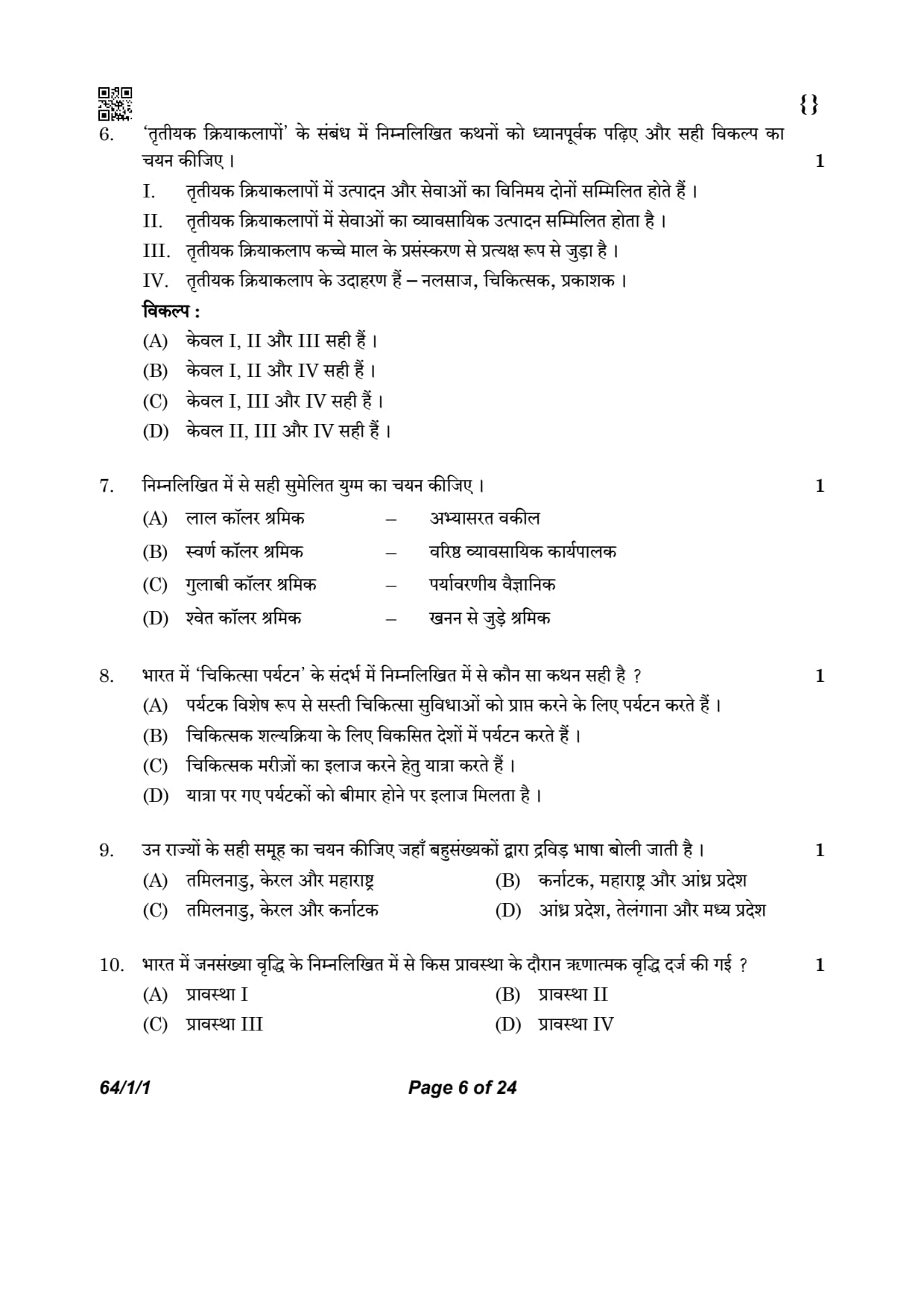
Read the following statements carefully regarding ‘tertiary activities’ and choose the correct option :
I. Tertiary activities include both production and exchange of services.
II. Tertiary activities involve the commercial output of services.
III. Tertiary activities are directly involved in the processing of raw material.
IV. The examples of tertiary activities are – plumber, doctor, publisher.
Detailed Solution
Concept:
Tertiary activities involve the provision of services rather than the production of tangible goods.
Unlike the secondary sector, these activities do not process raw materials into finished products.
They include trade, transport, communication, and various professional services.
Professionals like doctors, lawyers, and maintenance workers provide expertise rather than physical items.
Step 1: Understand the requirement of the question
The question requires identifying the correct statements that describe the characteristics and examples of tertiary activities.
Step 2: Analyse the provided statements
Statement I and II:
Tertiary activities encompass both the 'production' of services (like a doctor's consultation) and 'exchange' (like trade and transport).
They are measured by the commercial output of these services.
Statement III:
Direct involvement in the processing of raw material is a Secondary Activity.
This statement is incorrect for the tertiary sector.
Statement IV:
Plumbers, doctors, and publishers provide specialized services and information.
These are recognized examples of tertiary workers.
Step 3: Choose the correct option
Statements I, II, and IV are correct, while statement III is incorrect.
This corresponds to Option (B). Quick Tip: Tertiary sector = Service Sector.
It focuses on "expertise" and "delivery" rather than "manufacturing."
Remember: If it produces a physical product from raw materials, it is NOT tertiary.
Choose the correctly matched pair from the following.
Detailed Solution
Concept:
Workers are often classified by "collar colors" based on the nature of their work and sector.
Red Collar: Workers in the primary sector (agriculture, mining, etc.).
White Collar: Professional, administrative, or managerial workers.
Gold Collar: Highly skilled specialists or senior executives in quinary activities.
Pink Collar: Jobs in the service sector typically involving customer interaction or care.
Step 1: Understand the requirement of the question
We need to identify which collar color correctly matches the profession listed next to it.
Step 2: Analyse each pair
Option (A): Red collar worker – Practicing lawyers
Lawyers are white-collar professionals. Red collar is for primary activities.
Option (B): Gold collar worker – Senior business executive
Quinary activities (high-level decision making) are associated with gold collar workers.
This match is correct.
Option (C): Pink collar worker – Environmental scientist
Scientists are white-collar (quaternary) professionals.
Option (D): White collar worker – Mining worker
Mining is a primary activity, making these workers red-collar.
Step 3: Conclusion
Only the pair in Option (B) is correctly matched. Quick Tip: Red = Earth (Primary Sector).
Gold = High value/Decision making (Quinary Sector).
White = Office/Professional (Tertiary/Quaternary).
Which one of the following statements is true regarding ‘medical tourism’ in India ?
Detailed Solution
Concept:
Medical tourism is the practice of traveling to another country for the purpose of receiving medical treatment.
It usually involves patients from developed countries traveling to developing countries like India.
The primary drivers are high quality of care and significantly lower costs compared to their home countries.
Step 1: Understand the requirement of the question
The question asks for the defining characteristic of 'medical tourism' specifically in the Indian context.
Step 2: Evaluate the options
Option (A): Special travel for cheap facilities
This is the core definition. Patients plan trips specifically to undergo surgeries or treatments because it is cost-effective.
India is a global leader in this sector.
Option (D): Incidental treatment
Getting treated because one falls ill while on vacation is incidental healthcare, not medical tourism.
Step 3: Final reasoning
Medical tourism is a deliberate choice made by the tourist before the journey to seek specific medical benefits. Quick Tip: Medical Tourism = Healthcare + Tourism.
India is popular because of "state-of-the-art technology" and English-speaking staff at "low costs."
Choose the right group of states where Dravadian language is spoken majorly.
Detailed Solution
Concept:
Indian languages are divided into four main families: Indo-Aryan, Dravidian, Austric, and Sino-Tibetan.
The Dravidian family includes major languages like Tamil, Telugu, Kannada, and Malayalam.
These languages are predominantly spoken in South India.
Step 1: Identify the Dravidian languages and their states
Tamil: Tamil Nadu
Malayalam: Kerala
Kannada: Karnataka
Telugu: Andhra Pradesh and Telangana
Step 2: Analyse each option
Option (A) and (B):
These include Maharashtra, where Marathi (an Indo-Aryan language) is the primary language.
Option (D):
This includes Madhya Pradesh, where Hindi (Indo-Aryan) is the primary language.
Option (C):
Tamil Nadu, Kerala, and Karnataka all speak Dravidian languages as their majority language. Quick Tip: Indo-Aryan = North, West, and Central India.
Dravidian = South India (Peninsular India).
The "Big Four" Dravidian languages are Tamil, Telugu, Kannada, and Malayalam.
During which one of the following phase of population growth in India, negative growth was recorded in a decade ?
Detailed Solution
Concept:
India's population growth history is divided into four stages or phases.
Phase I (1901-1921): Stagnant growth.
Phase II (1921-1951): Steady growth.
Phase III (1951-1981): Population explosion.
Phase IV (Post-1981): High growth with signs of slowing down.
Step 1: Identify the decade with negative growth
During the census of 1921, looking back at the decade 1911-1921, India recorded a negative growth rate of \(-0.03%\).
This was due to poor health facilities, famines, and the 1918 influenza epidemic.
Step 2: Match the decade to the phase
The period from 1901 to 1921 is officially categorized as Phase I of population growth in India.
1921 is known as the "Great Divide" because growth became positive and steady thereafter. Quick Tip: 1911-1921 is the ONLY decade in Indian census history with negative growth.
Phase I = Stagnant/Negative growth.
1921 = The Year of the Great Divide.
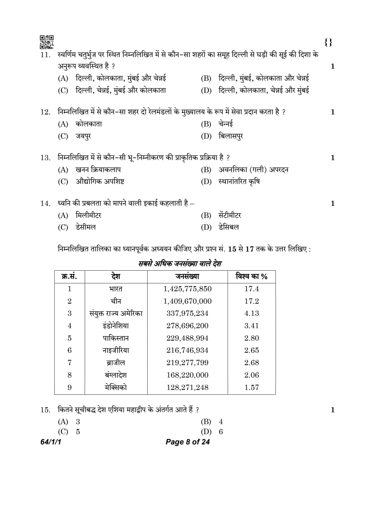
Which one of the following set of cities falling on the ‘Golden Quadrilateral’ are arranged in a clock-wise direction from Delhi ?
Detailed Solution
Concept:
The Golden Quadrilateral is a national highway network connecting India's four major metropolitan cities: Delhi, Mumbai, Chennai, and Kolkata.
Delhi is in the North, Kolkata in the East, Chennai in the South, and Mumbai in the West.
Step 1: Determine the geographical positions of the cities
Delhi is the northern vertex of the quadrilateral.
Kolkata is located to the east.
Chennai is located to the south.
Mumbai is located to the west.
Step 2: Arrange in clock-wise order
Starting from Delhi (North) and moving clockwise:
The next major city encountered is Kolkata (East).
Continuing clockwise, the next is Chennai (South).
Finally, moving up towards the west, we reach Mumbai (West).
This gives the sequence: Delhi \(\rightarrow\) Kolkata \(\rightarrow\) Chennai \(\rightarrow\) Mumbai. Quick Tip: Visualize the map of India.
Clockwise movement is North \(\rightarrow\) East \(\rightarrow\) South \(\rightarrow\) West.
Delhi (N), Kolkata (E), Chennai (S), Mumbai (W).
Which one of the following cities serve as headquarter of two railway zones ?
Detailed Solution
Concept:
Indian Railways is divided into several zones for administrative efficiency.
Most zones have a single city as their headquarters, but some major metros host more than one.
Step 1: Identify the zones headquartered in Kolkata
Kolkata serves as the headquarters for the Eastern Railway and the South Eastern Railway.
(It also hosts the headquarters of the Kolkata Metro Railway).
Step 2: Evaluate other options
Chennai: Headquarters of Southern Railway.
Jaipur: Headquarters of North Western Railway.
Bilaspur: Headquarters of South East Central Railway.
Step 3: Conclusion
Since Kolkata hosts two major railway zones (Eastern and South Eastern), it is the correct answer. Quick Tip: Kolkata and Mumbai are the only two cities in India that serve as headquarters for more than one railway zone.
Mumbai = Central and Western Railway.
Kolkata = Eastern and South Eastern Railway.
Which one of the following is a natural process of land degradation ?
Detailed Solution
Concept:
Land degradation refers to the decline in the productive capacity of land.
It can be caused by human (anthropogenic) activities or natural physical processes.
Step 1: Identify human-induced degradation
Mining activities: Human extraction of minerals.
Industrial waste: Human pollution from factories.
Shifting cultivation: A human agricultural practice that leads to deforestation.
Step 2: Identify natural degradation
Gully erosion is a physical process where running water carves deep channels (gullies) in the soil.
While human activity can exacerbate it, the process itself is a natural geomorphological phenomenon. Quick Tip: Natural processes = Water erosion, Wind erosion, Salinity (in some cases).
Human processes = Mining, Overgrazing, Industrial dumping.
The loudness of the sound is measured in the unit known as :
Detailed Solution
Concept:
Sound intensity or loudness is a physical quantity that measures the pressure levels of sound waves.
Standard units are used to measure different dimensions like length, weight, and intensity.
Step 1: Define the units in the options
Millimeter and Centimeter: Units of length.
Decimal: A system of numbers or a point in a fraction.
Decibel (\( dB \)): A logarithmic unit used to express the ratio of sound intensity.
Step 2: Match loudness to its unit
The loudness of sound, which determines noise pollution levels, is measured in Decibels. Quick Tip: Normal conversation: \( 60\ dB \).
Pain threshold: Above \( 120\ dB \).
Noise pollution is usually measured over time as \( L_{eq} \).
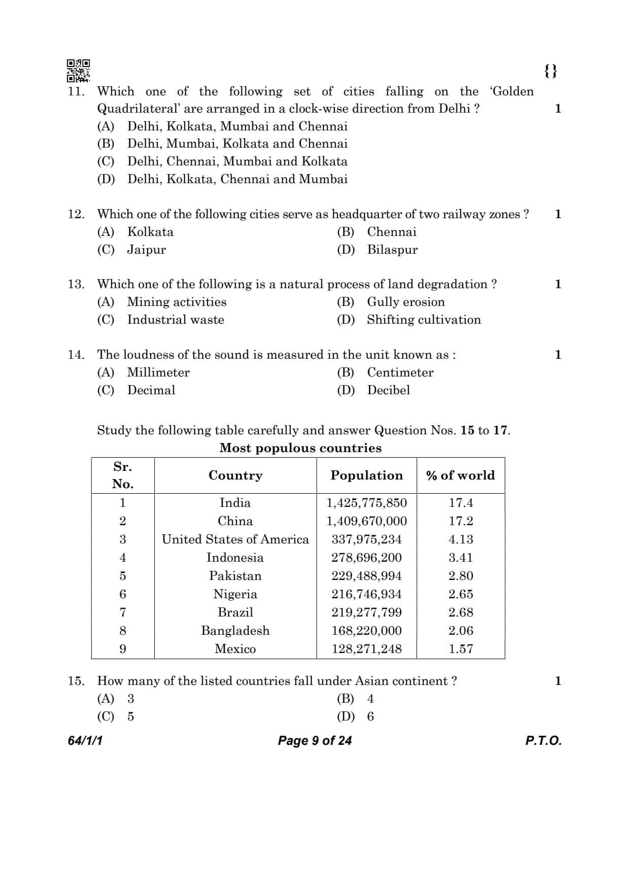
Study the following table carefully and answer Question Nos. 15 to 17.

How many of the listed countries fall under Asian continent ?
Detailed Solution
Concept:
This question requires analyzing the provided table "Most populous countries" and identifying which of the nine countries are located in Asia.
Step 1: List the countries from the table and their continents
India - Asia
China - Asia
USA - North America
Indonesia - Asia
Pakistan - Asia
Nigeria - Africa
Brazil - South America
Bangladesh - Asia
Mexico - North America
Step 2: Count the Asian countries
The countries in Asia are: India, China, Indonesia, Pakistan, and Bangladesh.
Total count = \( 5 \). Quick Tip: Asia is the most populous continent, hosting more than half of the world's 10 most populous nations.
Always double-check the location of countries like Indonesia and Pakistan in demographic data.
Which of the following set of continents is not represented in the table ? Choose the most appropriate option.
Detailed Solution
Concept:
This question requires cross-referencing the countries listed in the table with their respective continents.
The continents of the world are Asia, Africa, North America, South America, Antarctica, Europe, and Australia (Oceania).
Step 1: Identify the continents of the listed countries
The countries in the table are:
Asia: India, China, Indonesia, Pakistan, Bangladesh
North America: USA, Mexico
Africa: Nigeria
South America: Brazil
Step 2: Identify continents missing from the list
Based on Step 1, the continents Europe, Australia, and Antarctica are not represented by any country in the provided table.
Step 3: Match with the given options
Option (D) contains both Australia and Europe, neither of which is represented in the table. Quick Tip: In demographic tables, Europe is often underrepresented among the top 10 because most European nations have smaller, stable populations.
China and Brazil together account for what percentage of the world population ?
Detailed Solution
Concept:
The question asks for the combined percentage of the world's population shared by two specific countries based on the provided data.
Step 1: Extract percentages from the table
According to the table:
China accounts for \( 17.2% \) of the world population.
Brazil accounts for \( 2.68% \) of the world population.
Step 2: Calculate the total
Summing the two values: \[ 17.2% + 2.68% = 19.88% \] Quick Tip: Always align decimals correctly when adding percentages to avoid calculation errors.
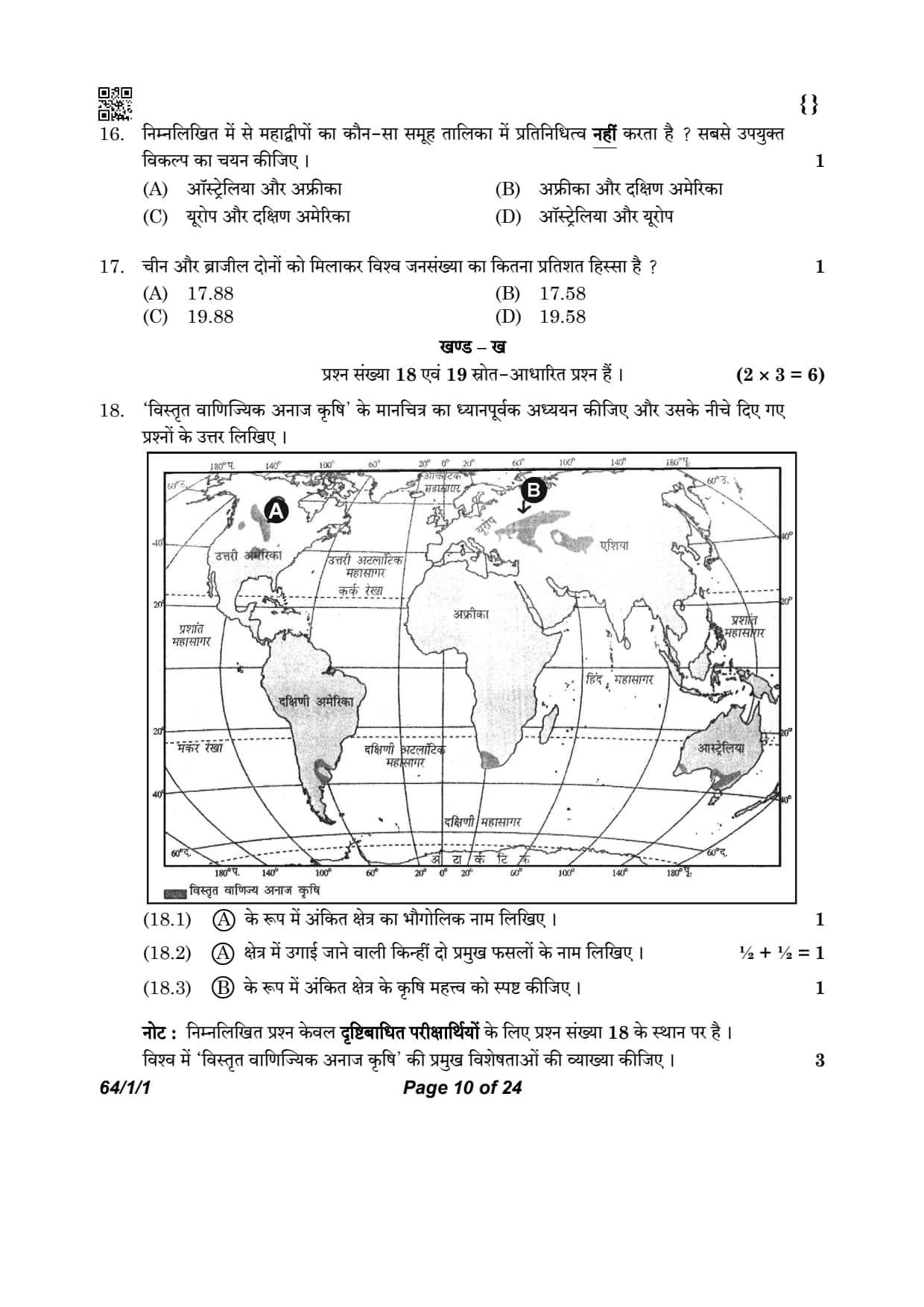
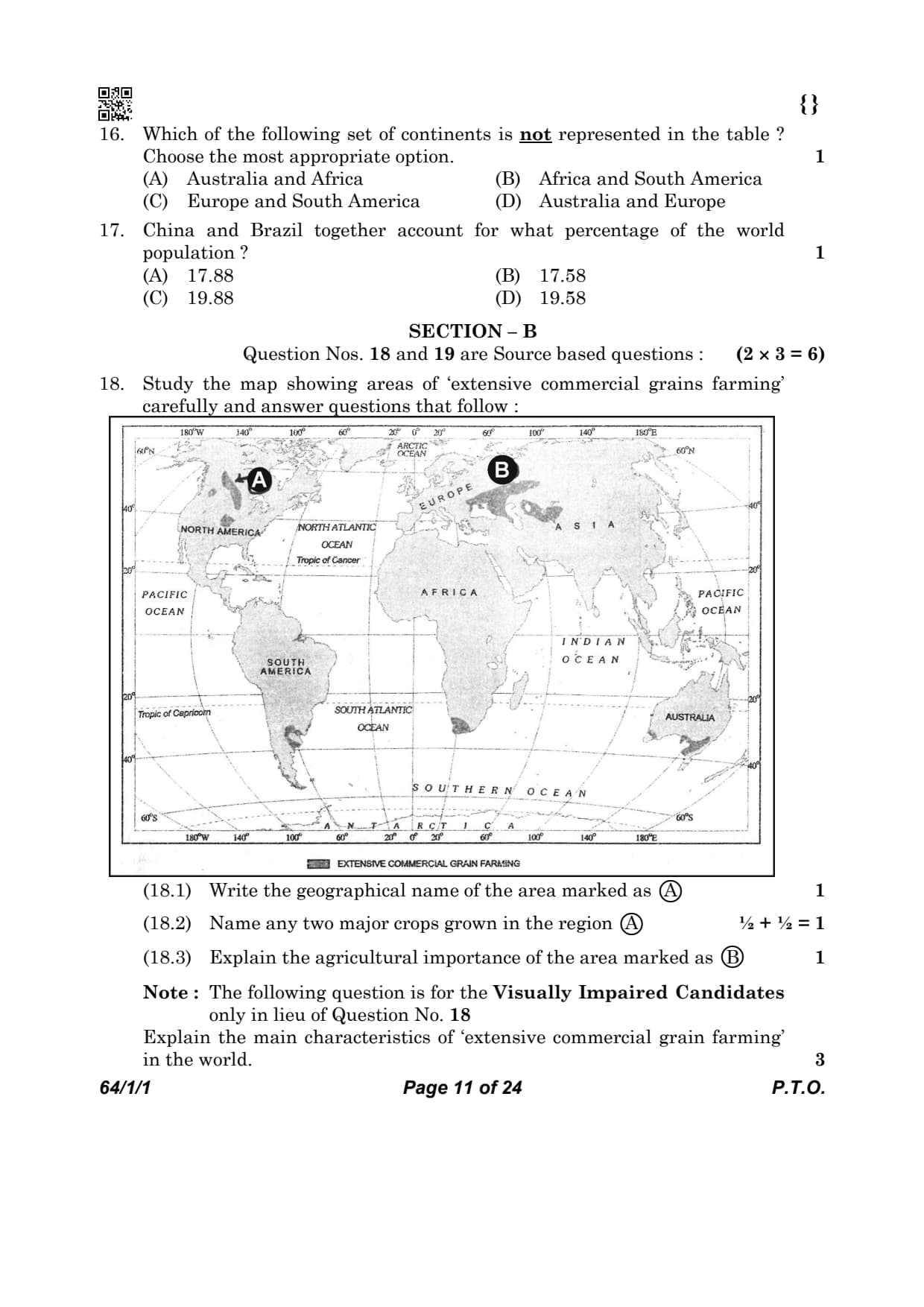
Study the map showing areas of ‘extensive commercial grains farming’ carefully and answer questions that follow :

Study the map showing areas of ‘extensive commercial grains farming’ carefully and answer the question: Write the geographical name of the area marked as (A).
Detailed Solution
Concept:
Extensive commercial grain farming is practiced in the interior semi-arid lands of the mid-latitudes.
These regions are large grasslands known by different names in different continents.
Step 1: Identify the location of area A
Area A is situated in the interior parts of North America (USA and Canada).
Step 2: Provide the regional name
The temperate grasslands of North America are geographically known as the Prairies. Quick Tip: Remember the regional names:
Prairies (North America), Steppes (Eurasia), Pampas (Argentina), Veld (South Africa), Downs (Australia), Canterbury Plains (New Zealand).
Name any two major crops grown in the region (A).
Detailed Solution
Concept:
Extensive commercial grain farming focuses on monoculture of grains suitable for semi-arid temperate grasslands.
Step 1: Identify the principal crop
Wheat is the principal crop of the Prairies.
Step 2: Identify other significant crops
Other crops grown include corn (maize), oats, barley, and rye.
Step 3: List two crops
Two major crops grown in the region are Wheat and Maize (Corn). Quick Tip: The Prairies are often referred to as the "Granaries of the World" due to massive wheat production.
Explain the agricultural importance of the area marked as (B).
Detailed Solution
Concept:
Area B represents the Steppes of Eurasia.
Extensive commercial grain farming in this region is characterized by large farm sizes and high mechanization.
Step 1: Identify the region
Area B refers to the Steppes of Eurasia (covering parts of Russia, Ukraine, and Central Asia).
Step 2: Explain its importance
It is one of the world's most productive wheat-growing regions.
Farming is highly mechanized, with low yield per acre but high yield per person.
It plays a crucial role in global food security by exporting surplus grain. Quick Tip: Extensive farming = High total production + High yield per person + Low yield per acre.
Note : The following question is for the Visually Impaired Candidates only in lieu of Question No. 18
Explain the main characteristics of ‘extensive commercial grain farming’ in the world.
Detailed Solution
Concept:
Extensive commercial grain farming is a highly mechanised type of commercial agriculture practised in the temperate grasslands of the world.
The main objective of this farming is the large-scale production of cereal crops, especially wheat.
It is carried out on vast farms with modern agricultural technology and very little human labour.
This type of farming is mainly practised in regions having low population density and extensive level plains.
Important regions include the Prairies of North America, Pampas of Argentina, Steppes of Eurasia, Velds of South Africa and Downs of Australia.
Step 1: Understand the nature of extensive commercial grain farming.
Extensive commercial grain farming is a specialised agricultural system where cereal crops are grown on very large farms for commercial purposes.
The produce is mainly sold in national and international markets rather than being consumed by the farming family.
This farming system requires large investments in machinery and modern technology to obtain high productivity.
Step 2: Explain the first characteristic.
1. Large-scale mechanised farming
Farms are very large in size, often extending over hundreds or even thousands of hectares.
Modern agricultural machinery such as tractors, seed drills, combine harvesters and threshers are extensively used for ploughing, sowing, harvesting and processing.
Because of mechanisation, only a small number of workers are required despite the enormous size of farms.
Step 3: Explain the second characteristic.
2. Specialisation in cereal crop production
The principal crop grown is wheat, although other cereals such as maize, barley and oats are also cultivated depending on climatic conditions.
Most farms specialise in one or two major cereal crops to maximise production and profits.
The harvested grains are stored in modern silos and transported efficiently through railways and ports for domestic consumption and export.
Step 4: Explain the third characteristic.
3. Practised in temperate grasslands with low population density
This farming system is mainly found in the temperate grassland regions where land is abundant and population density is low.
The level topography, fertile soils and moderate climate favour the cultivation of cereal crops.
Examples include the Prairies (North America), Pampas (Argentina), Steppes (Eurasia), Velds (South Africa) and Downs (Australia).
Step 5: Write the final answer.
Answer:
The main characteristics of extensive commercial grain farming are:
It is practised on very large farms using modern machinery such as tractors and combine harvesters, requiring comparatively less human labour.
It mainly produces cereal crops, especially wheat, on a commercial scale for national and international markets.
It is practised in the temperate grasslands of the world where fertile plains, low population density and favourable climatic conditions support large-scale mechanised farming. Quick Tip: • Practised in temperate grasslands.
• Very large farms with extensive mechanisation.
• Wheat is the principal crop; barley, oats and maize are also grown.
• Low population density and abundant land.
• Major regions: Prairies (USA & Canada), Pampas (Argentina), Steppes (Eurasia), Velds (South Africa) and Downs (Australia).
• Production is mainly for commercial sale and export.
Read the given passage carefully and answer the questions that follow :
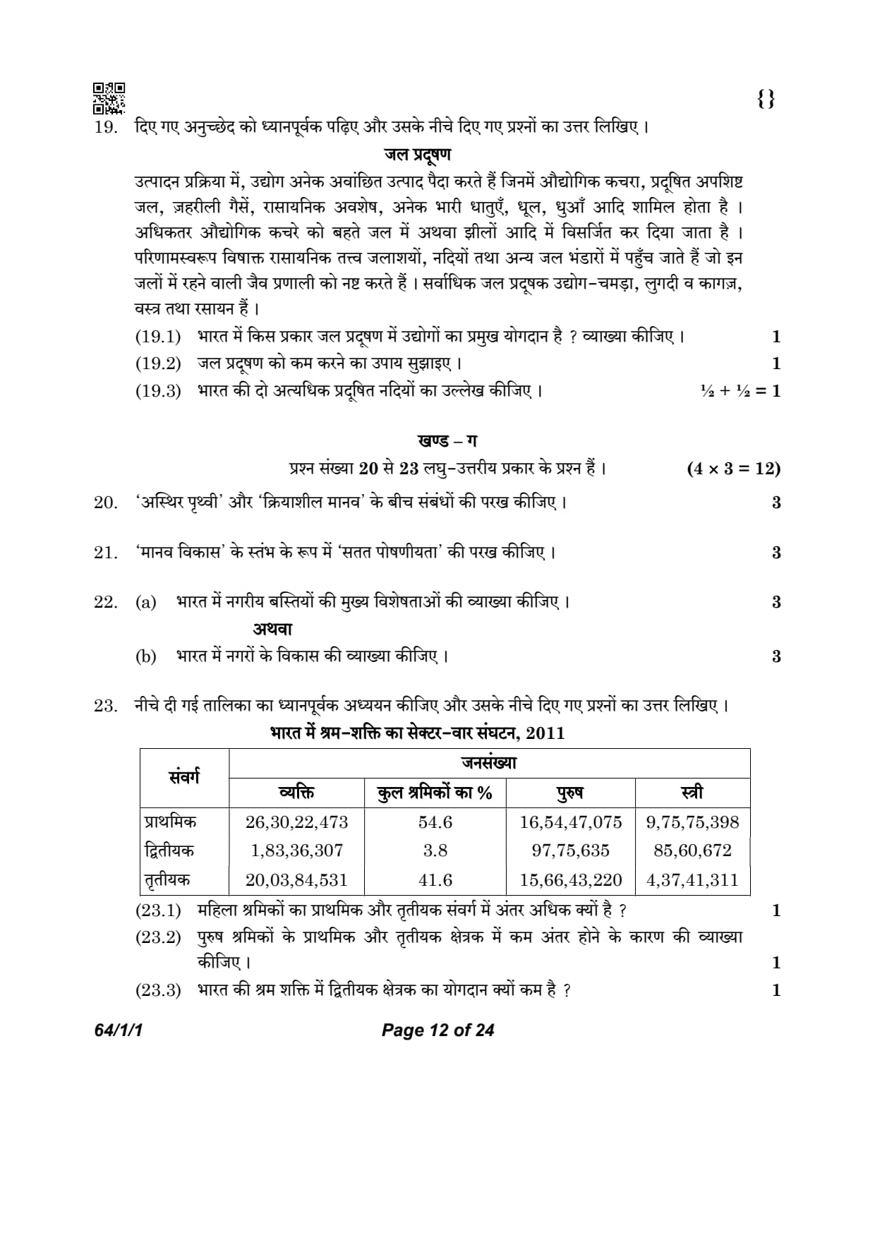
Water Pollution
Industries produce several undesirable products including industrial
wastes, polluted waste water, poisonous gases, chemical residuals,
numerous heavy metals, dust, smoke, etc. Most of the industrial wastes
are disposed off in running water or lakes. Consequently, poisonous
elements reach the reservoirs, rivers and other water bodies, which
destroy the bio-system of these waters. Major water polluting industries
are leather, pulp and paper, textiles and chemicals.
Explain how industries are the major contributor of water
pollution in India.
Detailed Solution
Concept:
Industrialization leads to the generation of various waste by-products.
Improper disposal of these wastes directly impacts the quality of water bodies.
Step 1: Identify the pollutants produced
Industries produce hazardous materials like heavy metals, chemical residuals, and polluted wastewater.
Step 2: Analyze the disposal method
Most industries dispose of their untreated effluents directly into rivers, lakes, or running water.
Step 3: Describe the impact
These poisonous elements contaminate reservoirs and destroy aquatic ecosystems (bio-systems), making the water unfit for use. Quick Tip: Organic wastes cause BOD (Biochemical Oxygen Demand) to rise, leading to the death of aquatic life.
Suggest the way for minimising water pollution.
Detailed Solution
Concept:
Minimizing pollution requires a combination of technical treatment, policy enforcement, and awareness.
Step 1: Recommend treatment methods
Industrial effluents must be treated in Effluent Treatment Plants (ETPs) before being discharged into water bodies.
Step 2: Suggest resource management
Recycling and reusing water within the industrial process can significantly reduce the volume of wastewater generated.
Step 3: Propose regulatory measures
Strict implementation of environmental laws and heavy penalties for unauthorized dumping are essential to deter pollution. Quick Tip: The "Polluter Pays Principle" is a globally recognized concept for managing industrial pollution.
Mention two rivers of India which are highly polluted.
Detailed Solution
Concept:
River pollution refers to the contamination of river water by harmful physical, chemical and biological substances.
Pollution reduces the quality of water and makes it unsuitable for drinking, irrigation, industrial use and aquatic life.
Rapid urbanisation, industrialisation, population growth and improper waste disposal have resulted in severe pollution of several rivers in India.
Untreated domestic sewage, industrial effluents, agricultural chemicals and religious activities are the major causes of river pollution.
According to the NCERT Geography textbook, the Ganga and the Yamuna are among the most polluted rivers in India.
Step 1: Identify the first highly polluted river.
The Yamuna River is one of the most polluted rivers in India.
Its water becomes highly polluted while passing through the National Capital Territory of Delhi due to the discharge of untreated domestic sewage, industrial waste, toxic chemicals and solid waste.
The stretch between Delhi and Etawah is considered one of the most polluted sections of the river.
Step 2: Identify the second highly polluted river.
The Ganga River is another major river facing severe pollution.
Although it is regarded as one of the holiest rivers in India, large quantities of untreated sewage, industrial effluents, municipal waste and religious offerings are discharged into the river.
Major cities such as Kanpur, Prayagraj and Varanasi contribute significantly to its pollution.
The Government of India has launched programmes like the Namami Gange Programme to restore the water quality of the river.
Step 3: Write the final answer.
Answer:
The two highly polluted rivers of India are:
Yamuna River
Ganga River Quick Tip: • Two highly polluted rivers of India are Yamuna and Ganga.
• Major causes of pollution include untreated sewage, industrial effluents, agricultural runoff and religious waste.
• The Government has launched the Namami Gange Programme to improve the water quality of the Ganga.
• These rivers are frequently asked examples in CBSE Class XII Geography examinations.
Examine the relationships between the ‘unresting man’ and ‘unstable earth’.
Detailed Solution
Concept:
This statement is part of Ellen Churchill Semple’s definition of Human Geography.
It emphasizes the dynamic and ever-changing nature of the relationship between humans and their environment.
Step 1: Define ‘unresting man’
'Unresting man' refers to the active nature of humans who are constantly struggling to survive and modifying the environment through activities like agriculture, industrialization, and urban development.
Step 2: Define ‘unstable earth’
'Unstable earth' signifies that the natural environment is not static. It is constantly changing due to geological processes, climate shifts, and natural cycles.
Step 3: Analyze the interaction
The relationship is mutual and continuous. Humans adapt to the changing earth, and in turn, the earth is transformed by human actions. There is no permanent state of equilibrium in this relationship. Quick Tip: Human Geography is essentially the study of "Change."
Semple belonged to the school of Environmental Determinism.
Examine the importance of ‘sustainability’ as a pillar of ‘human development’.
Detailed Solution
Concept:
Human development is supported by four pillars: equity, sustainability, productivity, and empowerment.
Sustainability refers to the continuity in the availability of opportunities over time.
It implies that all resources (environmental, financial, and human) must be used keeping the future in mind.
Step 1: Explain the core principle of sustainability
Sustainability means that each generation must have the same opportunities to utilize resources as the current generation.
If resources are over-exploited today, future generations will have fewer choices and lower development.
Step 2: Discuss resource management for development
To ensure human development is long-lasting, it is essential to manage resources efficiently.
For example, a country that exhausts its forests or groundwater today is depriving future children of those essential development inputs. Quick Tip: Sustainability = Inter-generational Equity.
It ensures that opportunities for future generations are not compromised by today's actions.
Explain the main characteristics of urban settlements in India.
Detailed Solution
Concept:
Urban settlements are characterized by high population density and a distinct economic base.
In India, these are defined by the Census based on population size, density, and occupational structure.
Step 1: Analyze the economic characteristics
The primary economic base of urban settlements is non-agricultural.
Most workers are engaged in secondary (industry), tertiary (services), and quaternary (specialized knowledge) activities.
Step 2: Analyze the demographic and infrastructural characteristics
Urban areas have a minimum population of \(5,000\) and a density of at least \(400\) persons per sq km.
They provide advanced infrastructure like hospitals, universities, and administrative offices to the surrounding rural hinterland. Quick Tip: Urban areas are "nodes" of economic growth and provide specialized services that rural areas cannot.
Explain the evolution of towns in India.
Detailed Solution
Concept:
Indian towns have evolved over different historical periods: Ancient, Medieval, and Modern.
Each phase reflects the socio-political and economic priorities of that era.
Step 1: Describe Ancient and Medieval towns
Ancient towns (like Varanasi and Pataliputra) evolved as religious and cultural centers more than \(2,000\) years ago.
Medieval towns (like Delhi and Hyderabad) emerged as capitals and fort-cities under various dynasties.
Step 2: Describe Modern towns
Modern towns were developed by the British and other Europeans, initially as coastal trading posts like Mumbai, Kolkata, and Chennai.
Later, they developed administrative towns, hill stations (Shimla), and industrial centers (Jamshedpur). Quick Tip: Timeline of Towns:
Ancient = Religion.
Medieval = Forts.
Modern = Trade/Administration.
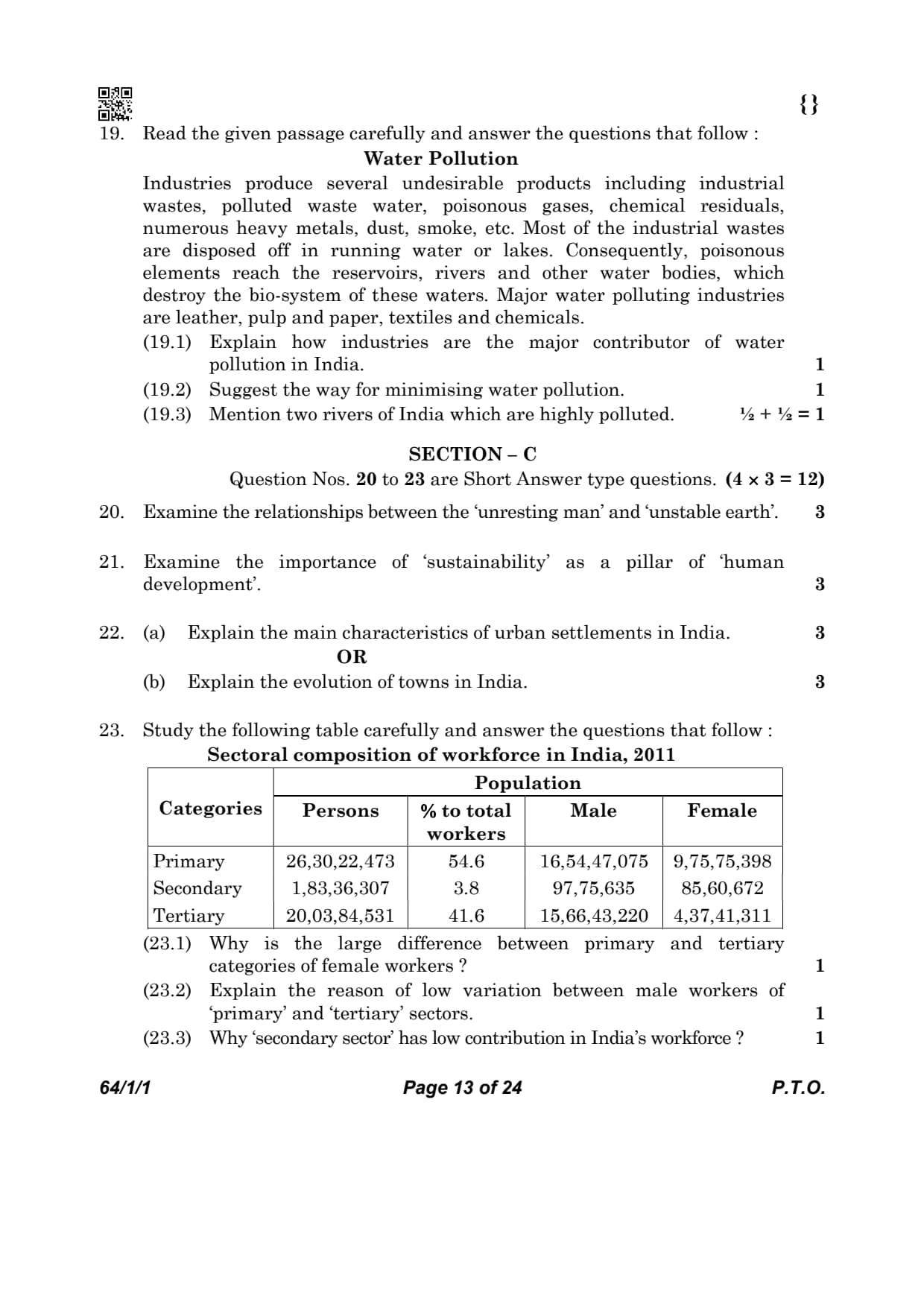
Study the following table carefully and answer the questions that follow :

Why is the large difference between primary and tertiary categories of female workers ?
Detailed Solution
Concept:
The occupational structure of the female workforce is heavily influenced by literacy levels.
Socio-economic conditions in rural areas play a major role in job selection.
Availability and nature of work dictate the sectoral distribution of workers.
Step 1: Evaluate the nature of agricultural work for females
Primary sector activities, especially agriculture, are highly accessible in rural India.
These activities do not require high levels of formal education or specialized skills.
Most rural women find work on family-owned farms or as agricultural laborers close to home.
This keeps the female workforce concentration high in the primary sector.
Step 2: Analyze the barriers to entering the tertiary sector
The tertiary or service sector generally requires higher literacy and technical skills.
Due to historical gaps in female education in India, many women lack these qualifications.
Jobs in services like banking, administration, or IT often require relocation to urban centers.
Social constraints and domestic responsibilities often limit female mobility to cities.
Step 3: Conclusion on the sectoral gap
The combination of low skill requirements in agriculture and high barriers in services creates a gap.
As a result, more than double the number of females work in the primary sector compared to the tertiary. Quick Tip: Primary sector jobs are "unorganized" and easier to access for rural populations.
Tertiary sector jobs are "organized" and require specific educational credentials.
Lower female literacy directly correlates to higher participation in agriculture.
Explain the reason of low variation between male workers of ‘primary’ and ‘tertiary’ sectors.
Detailed Solution
Concept:
Male workforce distribution is balanced due to high labor mobility.
Structural transformation in the economy affects male employment patterns.
Education and skill development are key drivers for sectoral shifts.
Step 1: Analyze the impact of male migration
Males in India exhibit higher rates of rural-to-urban migration for employment.
The search for better wages leads them away from stagnant agricultural sectors.
They move toward urban areas where service sector opportunities are concentrated.
This migration balances the workforce between the two sectors.
Step 2: Consider educational and skill attainment
Males have traditionally had better access to schooling and vocational training.
This enables a larger section of the male population to meet tertiary sector demands.
They can take up roles in transport, trade, administration, and professional services.
The resulting occupational diversity reduces the gap between primary and tertiary employment. Quick Tip: Work-related migration is a male-dominated phenomenon in India.
Higher mobility allows males to transition from "farm" to "non-farm" activities effectively.
Why ‘secondary sector’ has low contribution in India’s workforce ?
Detailed Solution
Concept:
The secondary sector involves manufacturing, processing, and construction.
India's economic transition has been unique compared to developed nations.
Capital-intensive growth often limits the absorption of surplus labor.
Step 1: Identify the "skipped" stage of industrialization
Unlike many developed countries, India moved directly from agriculture to services.
The manufacturing sector did not expand enough to become the main employer.
This structural quirk is often referred to as "jobless growth" in manufacturing.
Step 2: Analyze technological and capital factors
Modern manufacturing industries are increasingly automated and mechanized.
They require high capital investment but employ fewer manual workers.
Small-scale and cottage industries face stiff competition and lack growth.
Consequently, the secondary sector remains a small contributor to the total workforce. Quick Tip: The "Secondary Sector" is the processing stage of the economy.
In India, the tertiary sector grew much faster than the manufacturing sector.
Automation reduces the need for human labor in modern factories.
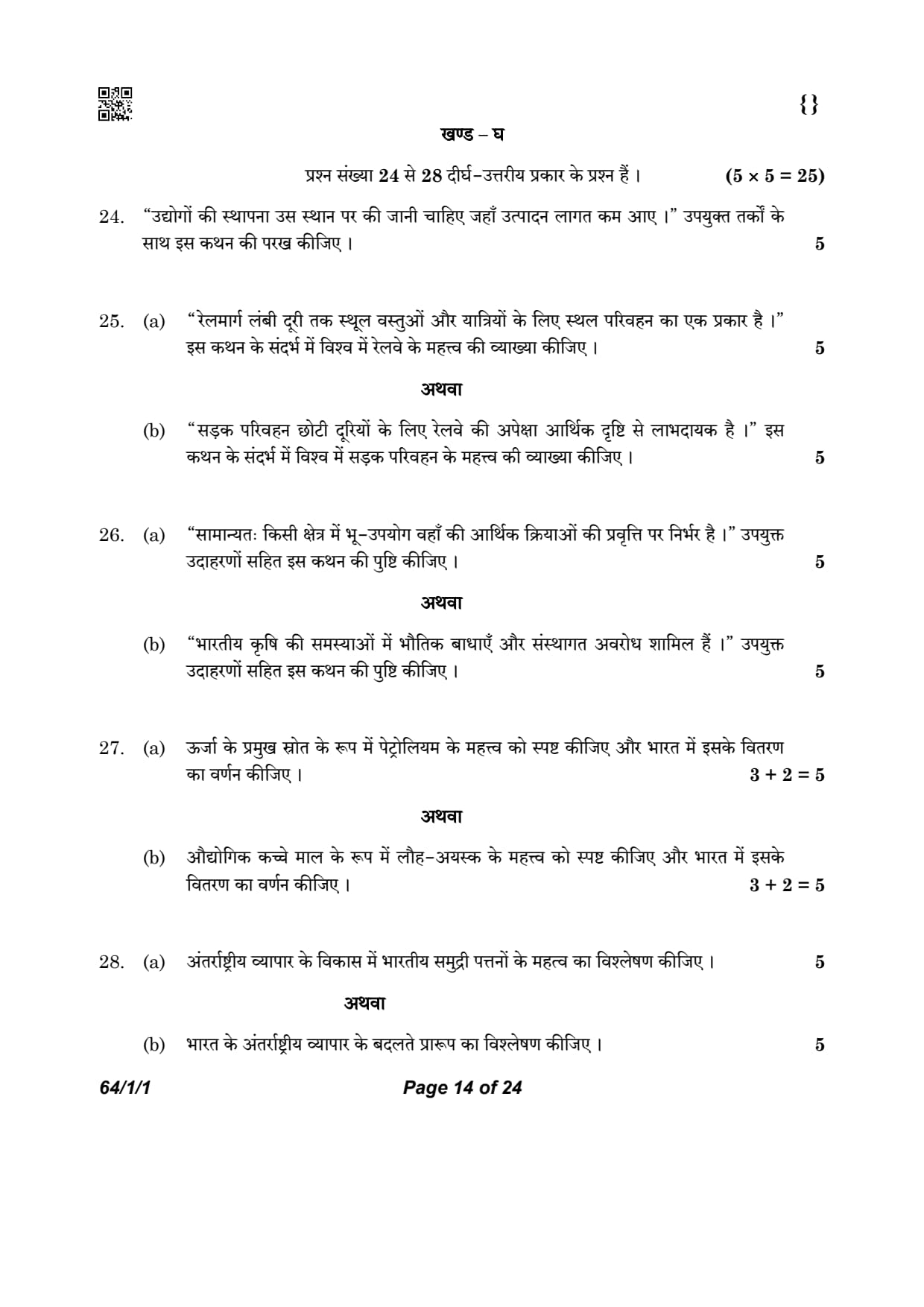
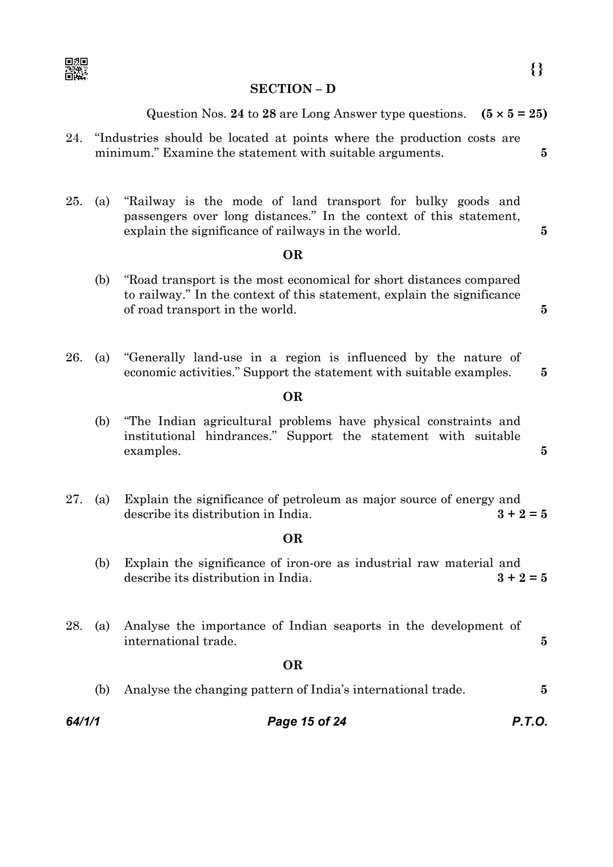
“Industries should be located at points where the production costs are minimum.” Examine the statement with suitable arguments.
Detailed Solution
Concept:
Industrial location is a strategic economic decision based on the Least Cost Principle.
Alfred Weber's theory highlights the role of transport and raw material costs.
Proximity to production factors determines the profitability of an industry.
Step 1: Argument regarding the cost of raw materials
Industries using bulky or weight-losing raw materials locate near the source.
Transporting heavy ores or perishable crops over long distances is expensive.
Locating near the source minimizes the "input" cost component.
Examples include Iron and Steel plants near coal/iron mines and Sugar mills near fields.
Step 2: Argument regarding proximity to markets
For finished goods that are fragile or gain weight, the market is the ideal location.
Transporting finished products to consumers adds significantly to the total cost.
Locating near urban centers reduces distribution and logistical expenses.
Examples include petroleum refineries and daily consumer goods industries.
Step 3: Argument regarding labor and power costs
Availability of cheap and skilled labor reduces the operational wage bill.
Continuous and affordable power supply is a pre-requisite for modern factories.
Industries often move to regions with lower utility rates and favorable labor laws.
This helps in maintaining the lowest possible "cost per unit" of production.
Step 4: Argument regarding agglomeration and policy
Agglomeration allows industries to share infrastructure and specialized services.
Proximity to related industries reduces the cost of repairs and maintenance.
Government incentives and tax breaks also lower the effective cost of production.
Rational entrepreneurs choose locations where all these costs are minimized. Quick Tip: Profit Maximization = Total Revenue - Total Cost.
Since market prices are often competitive, minimizing costs is the best way to profit.
The "Least Cost Point" is the most geographical location for any industry.
“Railway is the mode of land transport for bulky goods and passengers over long distances.” In the context of this statement, explain the significance of railways in the world.
Detailed Solution
Concept:
Railways are the most efficient mode of land transport for large-scale movement.
They are highly cost-effective for long-haul freight operations.
Railways act as the backbone for the industrial and economic integration of a nation.
Step 1: Evaluate the capacity for handling bulky goods
Railways can transport massive volumes of heavy commodities in a single trip.
Goods like coal, iron ore, timber, and grains are moved efficiently across continents.
This heavy-lifting capability is essential for primary and secondary industries.
No other land mode can match the "ton-kilometer" efficiency of a train.
Step 2: Explain the long-distance cost advantage
For travel across hundreds of kilometers, railways are much cheaper than road transport.
The friction of steel wheels on steel rails is very low, reducing energy consumption.
Large numbers of passengers can be moved at affordable prices over long distances.
This facilitates labor migration and tourism on a continental scale.
Step 3: Analyze the role in continental integration
Trans-continental railways connect the interior of continents to the coastal ports.
They enable the exploitation of resources in remote and landlocked regions.
Examples like the Trans-Siberian railway show how railways unify vast territories.
They provide a stable, all-weather mode of transport for global trade networks. Quick Tip: Railways = Bulk handling + Long distance + Energy efficiency.
They are vital for "heavy" industrialization.
Inland trade depends heavily on the railway network for raw material supply.
“Road transport is the most economical for short distances compared to railway.” In the context of this statement, explain the significance of road transport in the world.
Detailed Solution
Concept:
Road transport provides the highest level of flexibility and accessibility.
It is the primary mode for last-mile connectivity in the transport chain.
Roads can be constructed in diverse and challenging geographical terrains.
Step 1: Explain the advantage of door-to-door service
Roads are the only mode that can provide connectivity directly to a doorstep.
They connect farms to markets and factories to individual consumers.
This eliminates the need for multiple trans-shipments of goods.
This "last-mile" reach is the most unique significance of road transport.
Step 2: Discuss flexibility and short-distance economy
For short trips, road transport is faster and cheaper as it avoids terminal delays.
Unlike trains, vehicles can be stopped and started according to the user's need.
Loading and unloading costs are relatively low for small batches of goods.
This makes roads ideal for perishable goods and localized distribution.
Step 3: Analyze the role as a feeder to other modes
Roads serve as the feeder system for railways, airways, and seaports.
Every other mode of transport depends on roads to deliver cargo to its terminals.
Additionally, roads can be built on steep slopes and across rugged mountains.
They are indispensable for providing basic services to remote and hilly regions. Quick Tip: Roads = Flexibility + Accessibility + Feeder System.
They are the most pervasive form of transport infrastructure.
"Door-to-door" service is the key competitive advantage of roads.
“Generally land-use in a region is influenced by the nature of economic activities.” Support the statement with suitable examples.
Detailed Solution
Concept:
Land-use refers to the functional utilization of land for various purposes.
The intensity and type of land-use are directly proportional to the stage of economic development and the nature of predominant economic activities in a region.
As an economy shifts from primary to secondary and tertiary sectors, the demand for non-agricultural land increases.
Step 1: Influence of Primary Activities on Rural Land-use
In regions dominated by primary activities like agriculture, the vast majority of land is used for cultivation, pastures, and forests.
The land-use pattern is dictated by soil fertility and water availability.
For example, in the Indo-Gangetic plains, the high productivity of land keeps it under intensive crop cultivation.
Step 2: Shift to Non-agricultural Land-use due to Industrialization
As secondary and tertiary activities grow, land is diverted for building factories, warehouses, and offices.
Infrastructure like roads, railways, and airports requires large tracts of land that were previously used for agriculture or left as open spaces.
Example: The conversion of agricultural land into Industrial Estates in peripheral areas of large cities.
Step 3: Urban Land-use and Economic Specialization
In urban areas, land-use is highly specialized into residential, commercial, and administrative zones.
The high value of land in the Central Business District (CBD) leads to vertical expansion (high-rises) to maximize economic output per unit of land area.
This illustrates how high-value economic activities demand specific land-use patterns.
Step 4: Pressure on land due to Population and Economic Growth
With economic growth, the increasing population puts pressure on available land, leading to land reclamation and the conversion of 'culturable waste' into productive use.
Even marginal lands are brought under use for specialized economic activities like mining or solar power plants. Quick Tip: Land-use is dynamic; it changes as the economic structure of a society moves from agrarian to industrial and service-oriented.
Non-agricultural land-use is a key indicator of urbanization.
“The Indian agricultural problems have physical constraints and institutional hindrances.” Support the statement with suitable examples.
Detailed Solution
Concept:
Indian agriculture is the backbone of the economy but faces a multitude of challenges.
These problems can be categorized into natural/environmental factors (physical) and socio-economic/legal factors (institutional).
Step 1: Physical Constraints: Dependence on Erratic Monsoon
A significant portion of Indian agriculture still relies on rainfall.
The unpredictability of the South-West monsoon leads to frequent droughts in some regions and floods in others.
Example: Low rainfall in the Vidarbha region often leads to crop failure and agricultural distress.
Step 2: Physical Constraints: Land Degradation and Soil Erosion
Intensive cultivation and faulty agricultural practices have led to soil salinity, alkalinity, and depletion of nutrients.
In states like Punjab and Haryana, over-irrigation has caused waterlogging and soil degradation, limiting future productivity.
Step 3: Institutional Hindrances: Small and Fragmented Land Holdings
Due to inheritance laws, land is divided into very small plots with each passing generation.
Small land holdings (\( < 1 \) hectare) make it economically unviable to use modern machinery or intensive irrigation techniques.
This prevents "economies of scale" in production.
Step 4: Institutional Hindrances: Lack of Credit and Land Reforms
Many farmers still lack access to institutional credit (banks) and fall into the trap of private moneylenders.
Furthermore, incomplete land reforms in many states mean that actual tillers often do not own the land, reducing their incentive to invest in long-term land improvements. Quick Tip: Physical problems relate to "nature" (rain, soil, terrain).
Institutional problems relate to "systems" (law, ownership, money).
Solving Indian agriculture requires both technological and policy-level interventions.
Explain the significance of petroleum as major source of energy and describe its distribution in India.
Detailed Solution
Concept:
Petroleum (crude oil) is an essential liquid mineral used for both energy and as a raw material for various industries.
It is often called "Black Gold" due to its immense economic value.
In India, petroleum is found in sedimentary basins associated with the tertiary period.
Step 1: Significance of Petroleum as an Energy Source and Raw Material
It provides fuel for all internal combustion engines in road, rail, and air transport.
It is a concentrated source of energy that is easily portable via pipelines or tankers.
It serves as a vital lubricant for all types of industrial machinery.
It acts as the primary raw material for the petrochemical industry, producing fertilizers, synthetic fibers, plastics, and medicines.
Step 2: Distribution of Petroleum in India
Western Offshore: The largest producer is Mumbai High, followed by the Bassein field.
Gujarat: Major fields include Ankaleshwar (the most important), Kalol, and Mehsana.
Assam: The oldest oil-producing state. Major fields are Digboi, Naharkatiya, and Moran-Hugrijan.
Eastern Coast: New discoveries have been made in the Krishna-Godavari (KG) and Kaveri basins. Quick Tip: Petroleum is found in "anticlines" and "fault traps" in sedimentary rocks.
Mumbai High accounts for the largest share of India's domestic oil production.
Explain the significance of iron-ore as industrial raw material and describe its distribution in India.
Detailed Solution
Concept:
Iron ore is the basic mineral and the backbone of industrial development.
India is endowed with fairly abundant resources of iron ore, particularly high-grade hematite and magnetite.
Step 1: Significance of Iron Ore as Industrial Raw Material
It is the primary raw material for the Iron and Steel industry, which provides the foundation for all other manufacturing.
Steel produced from iron ore is used for machinery, transport equipment (ships, trains, cars), construction, and defense tools.
It is crucial for the development of infrastructure like bridges, power plants, and railways.
High-grade iron ore exports are a significant source of foreign exchange for India.
Step 2: Distribution of Iron Ore in India
Odisha-Jharkhand Belt: High-grade hematite is found in Badampahar mines (Mayurbhanj and Kendujhar) in Odisha and Gua and Noamundi in Jharkhand.
Durg-Bastar-Chandrapur Belt: Located in Chhattisgarh and Maharashtra. Famous for the Bailadila mines which produce very high-quality hematite.
Ballari-Chitradurga-Chikkamagaluru-Tumakuru Belt: Located in Karnataka. The Kudremukh mines are a 100 percent export unit.
Maharashtra-Goa Belt: Includes the state of Goa and Ratnagiri district of Maharashtra. These ores are exported through Marmagao port. Quick Tip: Magnetite is the finest iron ore with very high iron content (up to \( 70% \)).
Hematite is the most important industrial iron ore in terms of quantity used.
Analyse the importance of Indian seaports in the development of international trade.
Detailed Solution
Concept:
Seaports are known as the "Gateways of International Trade."
For a country like India, with a long coastline of \( 7,517\ km \), ports handle more than \( 95% \) of international trade by volume and \( 70% \) by value.
They provide the interface between maritime transport and land transport.
Step 1: Handling Bulk Cargo and Economic Efficiency
Ports are essential for handling bulky and heavy cargo like petroleum, iron ore, coal, and fertilizers.
Maritime transport is the cheapest mode of transport for long distances, making Indian exports competitive in the global market.
Seaports facilitate the large-scale import of crude oil, which is the energy lifeline of the Indian economy.
Step 2: Connecting Hinterland to the World
Seaports serve as collecting and distributing centers for their vast hinterlands.
For example, the Mumbai port serves the industrial heartland of Maharashtra and Gujarat, while Kandla port handles the requirements of the grain-surplus Northern states.
This allows regional industries to access global markets and import necessary technology or raw materials.
Step 3: Development of Port-led Infrastructure
The presence of major ports (like Chennai, Visakhapatnam, and JNPT) leads to the development of Special Economic Zones (SEZs) and industrial corridors.
This attracts Foreign Direct Investment (FDI) and promotes export-oriented manufacturing, which is a major driver of national GDP. Quick Tip: India has 12 major ports and 200 notified minor/intermediate ports.
Modernizing ports through the "Sagarmala" project is key to boosting India's share in global trade.
Analyse the changing pattern of India’s international trade.
Detailed Solution
Concept:
India's international trade has undergone significant changes since independence, especially after the 1991 economic reforms.
The "pattern" refers to the composition (what we trade) and the direction (with whom we trade).
Step 1: Changing Composition of Exports
India has moved from being an exporter of primary products (like tea, jute, and cotton) to an exporter of manufactured and high-value goods.
There has been a sharp increase in the export of petroleum products, gems and jewelry, chemicals, and engineering goods.
The growth of the software and IT-enabled services (ITES) sector has also transformed India into a global services export hub.
Step 2: Changing Composition of Imports
While petroleum (POL) remains the largest import item, there is a shift toward importing sophisticated machinery, electronic goods, and precious metals.
The import of food grains has declined significantly as India became self-sufficient, but the import of edible oils and pulses continues to fill domestic gaps.
Step 3: Shifting Direction of Trade
Historically, India's trade was dominated by the UK and USA.
Currently, trade with Asian countries (like China, UAE, and ASEAN nations) and African nations has increased significantly.
The USA remains a major partner, but India has successfully diversified its trade partners to reduce dependence on any single region. Quick Tip: Pattern shift = Primary goods \(\rightarrow\) Manufactured goods/Services.
India's trade deficit is primarily due to high petroleum and gold imports.
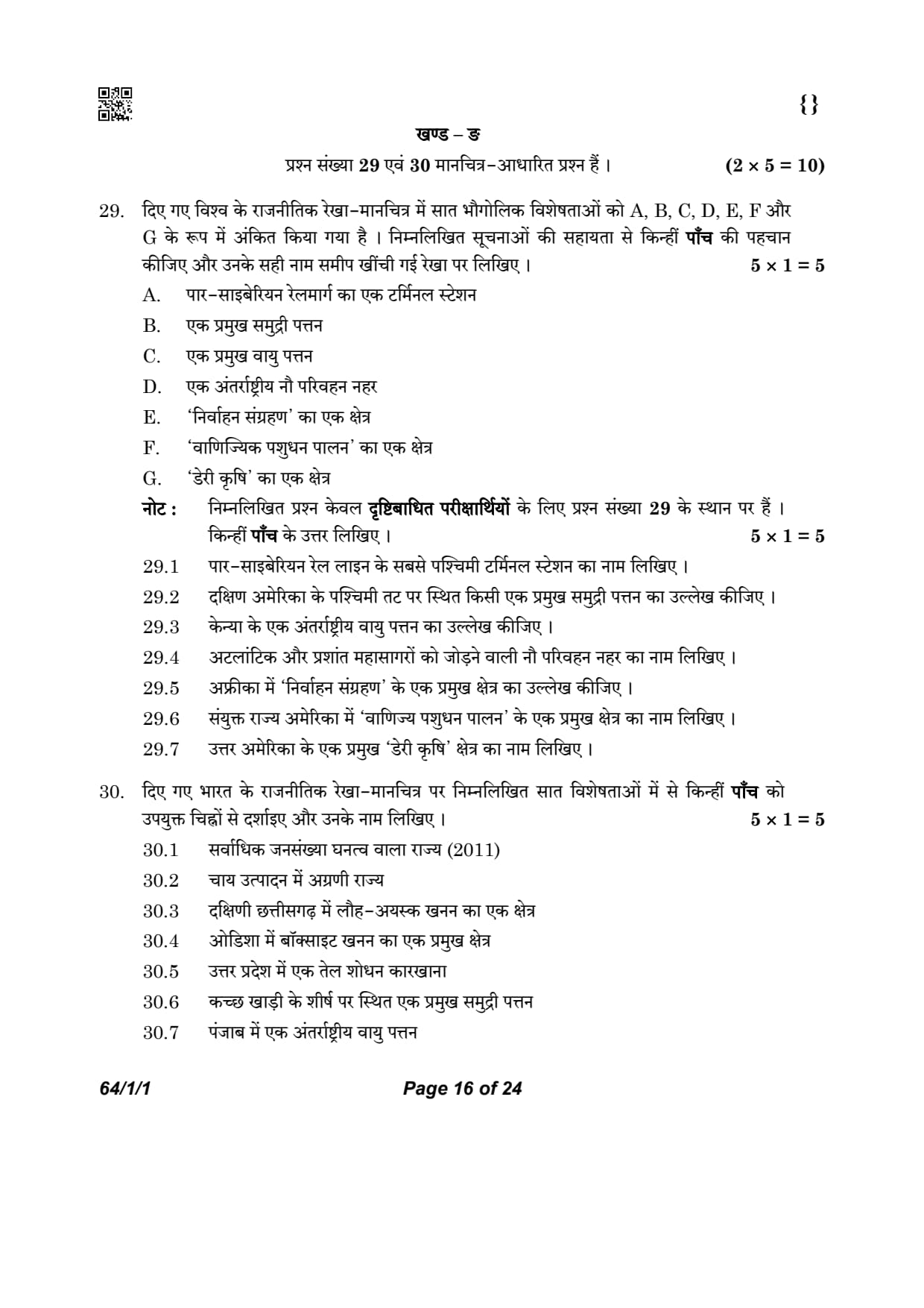
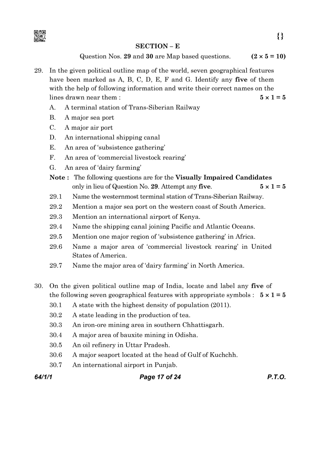
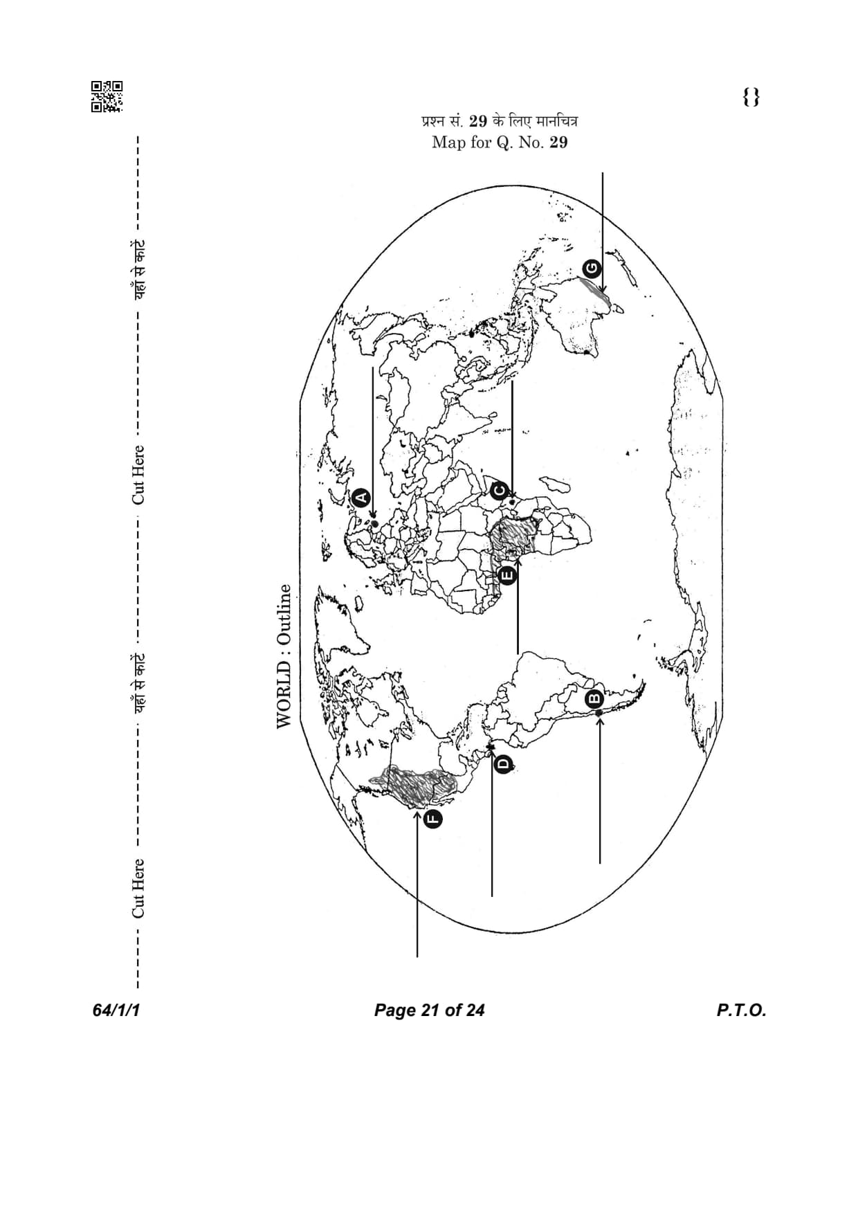
In the given political outline map of the world, seven geographical features have been marked as A, B, C, D, E, F and G. Identify any five of them with the help of following information and write their correct names on the lines drawn near them
A. A terminal station of Trans-Siberian Railway
B. A major sea port
C. A major air port
D. An international shipping canal
E. An area of ‘subsistence gathering’
F. An area of ‘commercial livestock rearing’
G. An area of ‘dairy farming’

Detailed Solution
Concept:
Map work is an important component of CBSE Class XII Geography and tests the student's ability to identify major geographical features correctly.
These features may include important transport routes, sea ports, international airports, agricultural regions, natural vegetation regions and economic activities.
Identification is based on the geographical location of the feature, surrounding countries, neighbouring oceans and physical characteristics shown on the political map.
Careful observation of the continent, latitude, coastline and nearby countries helps in identifying the correct geographical feature.
The following features have been correctly identified from the given world political map.

Step 1: Identify Feature A.
The marked city in western Russia represents the eastern terminal region associated with the Trans-Siberian Railway.
\[ \boxed{\textbf{A -- St. Petersburg}} \]
Step 2: Identify Feature B.
The marked city on the western coast of South America represents one of the major sea ports of Chile.
\[ \boxed{\textbf{B -- Valparaiso}} \]
Step 3: Identify Feature C.
The marked city in East Africa represents an important international airport.
\[ \boxed{\textbf{C -- Nairobi}} \]
Step 4: Identify Feature D.
The marked waterway connecting the Atlantic Ocean and the Pacific Ocean through Central America is the famous international shipping canal.
\[ \boxed{\textbf{D -- Panama Canal}} \]
Step 5: Identify Feature E.
The shaded region in Central Africa represents an area where subsistence gathering is widely practised.
\[ \boxed{\textbf{E -- Tropical Africa}} \]
Step 6: Identify Feature F.
The shaded region in the western part of the United States represents an important area of commercial livestock rearing.
\[ \boxed{\textbf{F -- United States of America}} \]
Step 7: Identify Feature G.
The marked region in south-eastern Australia represents one of the world's important dairy farming regions.
\[ \boxed{\textbf{G -- South-Eastern Australia}} \] Quick Tip: • A \(\rightarrow\) St. Petersburg (Terminal Station of Trans-Siberian Railway)
• B \(\rightarrow\) Valparaiso (Major Sea Port, Chile)
• C \(\rightarrow\) Nairobi (Major International Airport, Kenya)
• D \(\rightarrow\) Panama Canal (Connects the Atlantic and Pacific Oceans)
• E \(\rightarrow\) Tropical Africa (Subsistence Gathering Region)
• F \(\rightarrow\) United States of America (Commercial Livestock Rearing Region)
• G \(\rightarrow\) South-Eastern Australia (Major Dairy Farming Region)
• For world map questions, first identify the continent, then observe nearby oceans, countries and important physical features before locating the correct answer.
Note : The following questions are for the Visually Impaired Candidates only in lieu of Question No. 29. Attempt any five.
Name the westernmost terminal station of Trans-Siberian Railway.
Detailed Solution
Concept:
The Trans-Siberian Railway is the longest railway system in the world, stretching across the entire width of Russia.
It was constructed between 1891 and 1916 to connect European Russia with the Russian Far East.
The railway has two major terminals: St. Petersburg in the west and Vladivostok in the east.
Step 1: Analyse the geographical location of Point A
On the provided map, Point A is located in the far western section of the Russian Federation.
It is situated at the head of the Gulf of Finland, which is an arm of the Baltic Sea.
This location is historically significant as Russia's "Window to the West."
Step 2: Identify the specific railway terminal
Given that the location is in Western Russia and is the starting point of the Trans-Siberian route toward the Pacific, the city is St. Petersburg.
St. Petersburg serves as a vital economic hub and the western gateway for trans-continental rail traffic.
Step 3: Verify the identification
The Trans-Siberian line traditionally starts at the Moscow Station in St. Petersburg and travels through Moscow, the Ural Mountains, and the Siberian plains.
Therefore, the feature marked as (A) is St. Petersburg. Quick Tip: Always remember: St. Petersburg is the Western Terminal, and Vladivostok is the Eastern Terminal of the Trans-Siberian Railway.
This railway facilitates the movement of bulky goods like timber and coal across Eurasia.
Mention a major sea port on the western coast of South America.
Detailed Solution
Concept:
Sea ports are gateways for international trade, providing an interface between land and sea transport.
Major ports are often developed near industrial or resource-rich hinterlands to facilitate exports and imports.
Step 1: Examine the coastal location
Point B is located on the western coast of the South American continent.
The location is in the central part of the country of Chile, which has a very long coastline along the Pacific Ocean.
Step 2: Identify the specific port city
The major international sea port located at this latitude in Chile is Valparaiso.
It is the most significant port in the South Pacific and serves the capital city of Santiago, located inland.
Step 3: Explain the economic importance
Valparaiso handles a variety of cargo including minerals, fruits, and manufactured goods.
It was historically a vital stopover for ships traveling between the Atlantic and Pacific before the construction of the Panama Canal. Quick Tip: Valparaiso is a key hub for the Chilean economy and is often tested as a major Pacific coast port.
It is located roughly at \( 33^\circ S \) latitude.
Mention an international airport of Kenya.
Detailed Solution
Concept:
Air transport is the fastest mode of transport, essential for high-value cargo and long-distance travel.
Major airports in Africa serve as regional hubs for international connectivity.
Step 1: Determine the country and region
Point C is located in the East African region.
The political boundaries indicate that the point is within the borders of Kenya.
Step 2: Identify the aviation hub
The capital city of Kenya, Nairobi, hosts the Jomo Kenyatta International Airport.
Nairobi is the primary aviation hub for East Africa, connecting the continent to Europe, Asia, and other parts of Africa.
Step 3: Detail the significance
Nairobi's airport is crucial for the export of perishable items like flowers and for the thriving tourism industry in the East African rift valley and savannah regions. Quick Tip: Nairobi is a major commercial center in East Africa.
Always identify the country first (Kenya) to accurately name the major airport (Nairobi).
Name the shipping canal joining Pacific and Atlantic Oceans.
Detailed Solution
Concept:
Shipping canals are artificial waterways constructed to create shorter maritime routes.
They significantly reduce the time and cost of transporting goods across the globe.
Step 1: Identify the narrow land bridge
Point D is located at the narrow isthmus of Central America.
This is the geographical point that connects the continents of North America and South America.
Step 2: Identify the canal through the isthmus
The Panama Canal was constructed across this isthmus to connect the Atlantic Ocean (via the Caribbean Sea) and the Pacific Ocean.
It was opened in 1914 and uses a system of locks to move ships across the higher terrain of the interior.
Step 3: Analyse its trade significance
The canal saves ships approximately \( 13,000\ km \) of travel by avoiding the long and dangerous journey around the southern tip of South America (Cape Horn).
It is a cornerstone of world trade, particularly for traffic between the eastern USA and Asia. Quick Tip: The Panama Canal is about \( 82\ km \) long.
Don't confuse it with the Suez Canal, which is located in Egypt (connecting the Mediterranean and Red Seas).
Mention one major region of ‘subsistence gathering’ in Africa.
Detailed Solution
Concept:
Gathering is one of the oldest known primary economic activities.
Subsistence gathering is practiced in regions with harsh climates or dense forests where local communities collect fruits, roots, and plants for food and medicine.
Step 1: Identify the climatic zone
Point E is located along the Equator in the central part of the African continent.
This region is characterized by high temperatures and heavy rainfall throughout the year, supporting dense tropical rainforests.
Step 2: Name the specific geographical region
This area is the Congo Basin.
It is the world's second-largest tropical rainforest and is home to indigenous communities who still rely on the gathering of forest products for survival.
Step 3: Describe the activity
In the Congo Basin, gathering is often combined with hunting. Communities collect edible nuts, fruits, and medicinal barks.
This is a low-input, self-sufficient activity with almost no surplus produced for trade. Quick Tip: Major areas of subsistence gathering: Amazon Basin (S. America), Congo Basin (Africa), and the interior of SE Asia.
These areas have very low population density.
Name a major area of ‘commercial livestock rearing’ in United States of America.
Detailed Solution
Concept:
Commercial livestock rearing is a capital-intensive, organized activity where animals are raised on large ranches.
It is typical of temperate grasslands in the "New World" countries like the USA, Canada, and Argentina.
Step 1: Identify the landform and continent
Point F is located in the interior western section of North America, within the United States.
This region lies between the Mississippi River and the Rocky Mountains.
Step 2: Identify the specific livestock zone
The area corresponds to the Western USA (or Great Plains/Ranches).
In these semi-arid plains, cattle, sheep, and goats are reared on massive permanent ranches for their meat, wool, and skins.
Step 3: Describe the commercial nature
Unlike nomadic herding, this activity is highly scientific.
Animals are kept in fenced areas, and there is a high degree of mechanization in processing the animal products for the international market. Quick Tip: Ranching in the USA is a major contributor to the global beef and wool markets.
This area is geographically known as the Prairies.
Name the major area of ‘dairy farming’ in North America.
Detailed Solution
Concept:
Dairy farming is the most advanced type of rearing of milch animals.
It is usually practiced near large urban centers to ensure the supply of fresh milk and dairy products to the population.
Step 1: Identify the continent and specific region
Point G is marked at the south-eastern tip of Australia.
This region includes the coastal areas and fertile plains of Victoria and New South Wales.
Step 2: Identify the agricultural activity zone
The area is South Eastern Australia.
This is one of the three major world regions for dairy farming (the others being North Western Europe and Canada).
The temperate climate and proximity to cities like Melbourne and Sydney make it an ideal dairy belt.
Step 3: Explain the specialized nature
Dairy farming here involves high capital investment in cattle sheds, storage, and mechanized milking.
There is a focus on high-quality fodder and veterinary care for the cattle. Quick Tip: Dairy farming is highly localized near urban markets because milk is a perishable commodity.
Australia and New Zealand are world leaders in exporting butter and milk powder from these regions.
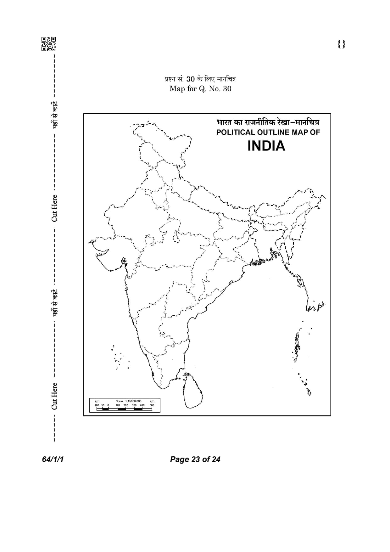
On the given political outline map of India, locate and label any five of the following seven geographical features with appropriate symbols :
1. A state with the highest density of population (2011).
2. A state leading in the production of tea.
3. An iron-ore mining area in southern Chhattisgarh.
4. A major area of bauxite mining in Odisha.
5. An oil refinery in Uttar Pradesh.
6. A major seaport located at the head of Gulf of Kuchchh.
7. An international airport in Punjab.

Detailed Solution
Concept:
Map-based questions in CBSE Geography evaluate the student's ability to identify important geographical features on the political outline map of India.
The features may include leading producing states, mineral belts, oil refineries, major ports, airports and demographic characteristics.
Correct identification requires knowledge of India's physical, economic and human geography.
While answering map-work questions, students should carefully observe state boundaries, coastlines and neighbouring states before marking the location.
The following geographical features have been correctly identified from the given political map of India.

Step 1: Identify Feature (30.1).
The shaded state located in the middle Ganga Plain has the highest population density according to the Census of India (2011).
\[ \boxed{\textbf{(30.1) -- Bihar}} \]
Step 2: Identify Feature (30.2).
The dotted state in the north-eastern part of India is the leading producer of tea.
\[ \boxed{\textbf{(30.2) -- Assam}} \]
Step 3: Identify Feature (30.3).
The marked location in southern Chhattisgarh represents one of India's richest iron-ore mining areas.
\[ \boxed{\textbf{(30.3) -- Bailadila}} \]
Step 4: Identify Feature (30.4).
The marked location in southern Odisha represents one of India's important bauxite mining regions.
\[ \boxed{\textbf{(30.4) -- Koraput}} \]
Step 5: Identify Feature (30.5).
The marked location in Uttar Pradesh represents an important oil refinery.
\[ \boxed{\textbf{(30.5) -- Mathura}} \]
Step 6: Identify Feature (30.6).
The marked location on the Gulf of Kuchchh represents one of India's major western sea ports.
\[ \boxed{\textbf{(30.6) -- Deendayal Port (Kandla)}} \]
Step 7: Identify Feature (30.7).
The marked location in Punjab represents an important international airport.
\[ \boxed{\textbf{(30.7) -- Amritsar (Sri Guru Ram Dass Jee International Airport)}} \]
Step 8: Final Answer
 Quick Tip: • 30.1 \(\rightarrow\) Bihar (Highest Population Density, Census 2011)
• 30.2 \(\rightarrow\) Assam (Leading Tea Producing State)
• 30.3 \(\rightarrow\) Bailadila (Iron-ore Mining Area, Chhattisgarh)
• 30.4 \(\rightarrow\) Koraput (Major Bauxite Mining Area, Odisha)
• 30.5 \(\rightarrow\) Mathura (Oil Refinery, Uttar Pradesh)
• 30.6 \(\rightarrow\) Deendayal Port (Kandla) (Major Seaport on the Gulf of Kuchchh)
• 30.7 \(\rightarrow\) Amritsar -- Sri Guru Ram Dass Jee International Airport (Punjab)
• In CBSE map-work questions, first identify the state, then carefully locate the city, mine, refinery, port or airport using nearby state boundaries and coastlines.
Note : The following questions are for the visually impaired candidates only in lieu of Question No. 30. Attempt any five.
Name the state with the highest density of population (2011).
Detailed Solution
Concept:
Density of population is expressed as the number of persons per unit area.
It helps in understanding the spatial distribution of population in relation to land.
According to the 2011 Census, the average density of population in India was \(382\) persons per square km.
Step 1: Compare the population density of various Indian states
As per the 2011 Census data, several states in the Indo-Gangetic plains and coastal areas have high densities.
In the previous census (2001), West Bengal held the top position.
Step 2: Identify the state with the maximum density
In 2011, Bihar recorded the highest population density among all Indian states, with \(1,106\) persons per square km.
This is primarily due to the fertile alluvial soil and flat terrain which support intensive agriculture and high settlement density. Quick Tip: Rank of Density (2011): 1. Bihar (\(1106\)), 2. West Bengal (\(1028\)), 3. Kerala (\(860\)).
Arunachal Pradesh has the lowest density (\(17\) persons per sq km).
Which state is leading in tea production ?
Detailed Solution
Concept:
Tea is a beverage crop grown on plantations.
It requires a tropical or sub-tropical climate with high rainfall (\(150--250\ cm\)) and well-drained, deep, friable loamy soil.
Step 1: Analyze the geographical distribution of tea in India
The major tea-producing regions in India are the Brahmaputra valley in the North-East, the Nilgiri hills in the South,
and the Darjeeling/Jalpaiguri districts in West Bengal.
Step 2: Identify the leading producer state
Assam:
is the undisputed leader in tea production in India.
It accounts for more than \(50%\) of the total tea produced in the country.
The Brahmaputra and Surma valleys provide the ideal undulating terrain and climatic conditions for tea bushes. Quick Tip: Assam = Quantity (Largest producer).
Darjeeling (West Bengal) = Quality (World famous aroma).
Name any one iron-ore mining area in Chhattisgarh.
Detailed Solution
Concept:
Chhattisgarh is one of the richest states in India in terms of iron ore reserves.
The iron ore found here is high-grade hematite, which is in great demand in the global market.
Step 1: Locate the iron ore belt in Chhattisgarh
Iron ore in Chhattisgarh is concentrated in the Durg-Bastar-Chandrapur belt.
The southern part of the state, particularly the Bastar and Dantewada districts, contains massive deposits.
Step 2: Identify the specific mining area
The most famous mining area in southern Chhattisgarh is Bailadila.
The name "Bailadila" means "hump of an ox," describing the shape of the range.
The ore from these mines is extremely high quality and is exported to Japan and South Korea via the Visakhapatnam port. Quick Tip: Bailadila is famous for its \(14\) deposits of super high-grade hematite iron ore.
It is a key source for India's iron ore exports.
Mention one bauxite mining area in Odisha.
Detailed Solution
Concept:
Bauxite is the primary ore used to produce aluminum.
It is formed by the decomposition of a wide variety of rocks rich in aluminum silicates.
Odisha is the largest bauxite-producing state in India, accounting for nearly half of the country's total output.
Step 1: Identify the bauxite-rich districts of Odisha
Major deposits are found in the Koraput, Rayagada, and Kalahandi districts. These form a part of the East Coast Bauxite belt.
Step 2: Locate the most significant mining site
The Panchpatmali deposits in the Koraput district are the most important bauxite deposits in Odisha.
These deposits feed large aluminum refineries like NALCO. Quick Tip: Odisha produces about \(51%\) of India's bauxite.
Panchpatmali is a plateau region known for its extensive and high-quality bauxite reserves.
Name the place where oil refinery is located in Uttar Pradesh.
Detailed Solution
Concept:
Oil refineries are industrial plants where crude oil is processed and refined into more useful products such as gasoline, diesel, and kerosene.
Refineries can be market-based (near consumers) or field-based (near oil wells).
Step 1: Search for oil refineries in North India
Since Uttar Pradesh is not an oil-producing state, its refineries are "market-based," meaning they are located close to large centers of demand.
Step 2: Identify the major refinery in UP
The Mathura Refinery, operated by the Indian Oil Corporation, is the only major oil refinery in Uttar Pradesh.
It is strategically located to cater to the high demand for petroleum products in the National Capital Region (NCR) and Western UP. Quick Tip: The Mathura refinery was controversial due to its proximity to the Taj Mahal and the potential impact of its emissions on the monument's marble.
Name the major sea port located on the head of Gulf of Kuchchh.
Detailed Solution
Concept:
Major seaports are the primary outlets for international trade.
Ports on the western coast handle trade with Europe, the Middle East, and Africa.
Step 1: Identify the geographical feature: Gulf of Kuchchh
The Gulf of Kuchchh is an inlet of the Arabian Sea along the west coast of India, in the state of Gujarat.
Step 2: Identify the port at the inner end (head) of the gulf
Kandla Port, now officially known as Deendayal Port, is located at the head of the Gulf of Kuchchh.
It was developed soon after independence to ease the volume of trade on the Mumbai port after the loss of Karachi port to Pakistan.
It is a "tidal port" and handles a huge volume of petroleum, fertilizers, and food grains. Quick Tip: Kandla was the first port in India to be declared a Free Trade Zone (FTZ).
It serves the vast hinterland of North and North-West India (Punjab, Haryana, Rajasthan, etc.).
Name the place where an international airport is located in
Punjab.
Detailed Solution
Concept:
International airports connect Indian states directly to global destinations.
Punjab, being a state with a large diaspora, requires significant international air connectivity.
Step 1: Search for major airports in Punjab
While Punjab has several domestic airports, only one major city hosts a primary international gateway.
Step 2: Identify the airport city
The major international airport in Punjab is located in
Amritsar.
It is known as the
Sri Guru Ram Dass Jee International Airport
(formerly Raja Sansi International Airport).
It is a crucial hub for the NRI population and for pilgrims visiting the Golden Temple. Quick Tip: Amritsar airport is named after the fourth Sikh Guru, Guru Ram Das, who founded the city of Amritsar.
CBSE Class 12 Geography Marks Distribution
| Section | Marks |
|---|---|
| Fundamentals of Human Geography | 35 |
| India: People and Economy | 35 |
| Practical Work (Part II) | 30 |
| Total | 100 |
CBSE Class 12 Geography Paper Analysis 2026
CBSE Class 12 Geography Set 1 - (64/1/1) Question Paper 2026 is available for download here. CBSE conducted class 12 Geography exam on February 26, 2026 from 10:30 AM to 1:30 PM.
Geography question paper includes 70 marks of theory paper and 30 marks of practical work, combining conceptual knowledge with fieldwork, map skills, and data interpretation. 35 marks are allotted to Fundamentals of Human Geography, 35 marks to India: People and Economy, and 30 marks to Practical Work in Geography - Part II.
You can download CBSE Class 12 Geography Set 1 - (64/1/1) Question Paper 2026 with Solutions from the links provided below.
CBSE Class 12 Geography Set 1 - (64/1/1) Question Paper 2026 with Solution PDF
| CBSE 2026 Class 12 Geography Set 1 - (64/1/1) Question Paper 2026 | Download PDF | Check Solutions |
Which of the following statements related to the concept of ‘development’ are correct ? Choose the appropriate option.
I. Development means positive change in life.
II. When positive growth is there, it is development.
III. When quantity is greater, it is development.
IV. Development is always relative to value.
Detailed Solution
Concept:
Development refers to a qualitative change that is always value positive.
This means development cannot take place unless there is an increment or addition to the existing conditions.
Growth is quantitative and value neutral.
It may be positive or negative.
Step 1: Analyze statements I and II.
Development always means a positive change in the quality of life.
Positive growth does not always lead to development, but development occurs when there is positive growth that improves quality.
Hence, I and II are correct.
Step 2: Analyze statements III and IV.
Statement III says greater quantity is development, but simple quantitative growth without qualitative improvement is not development.
Statement IV is correct because development is always relative to the positive values it brings to human life.
Therefore, statements I, II, and IV are correct. Quick Tip: Remember the formula: Positive Growth + Qualitative Change = Development.
Growth can be negative, but Development is always positive.
Match column-I with column-II correctly and choose the appropriate option :
Detailed Solution
Concept:
There are four main approaches to human development: Income, Welfare, Basic Needs, and Capability.
Each approach has a distinct focus on how to define and achieve human progress.
Step 1: Match Income and Welfare approaches.
The Income approach is one of the oldest approaches, where human development is linked to income (a-iii).
The Welfare approach looks at human beings as beneficiaries and focuses on government expenditure (b-iv).
Step 2: Match Basic Needs and Capability approaches.
The Basic Needs approach was proposed by the ILO and identifies six basic needs (c-i).
The Capability approach, associated with Prof. Amartya Sen, focuses on building human capabilities (d-ii).
The correct sequence is (D). Quick Tip: Keywords: Oldest = Income.
ILO = Basic Needs.
Beneficiaries = Welfare.
Capabilities = Capability Approach.
Which one of the following is the low latitudes zone of subsistence gathering practiced in the world ?
Detailed Solution
Concept:
Gathering is practiced in regions with very harsh climatic conditions.
It is carried out in high latitude zones and low latitude zones.
Step 1: Identify high latitude gathering zones.
High latitude zones include Northern Canada, Northern Eurasia, and Southern Chile.
Step 2: Identify low latitude gathering zones.
Low latitude zones include the Amazon Basin, Tropical Africa, and Southeast Asia.
Since the question asks for the low latitude zone, Southeast Asia is the correct answer. Quick Tip: Low latitude usually refers to the tropical belt (between the Tropics of Cancer and Capricorn).
High latitude refers to the Arctic or Sub-Antarctic regions.
Choose the correct option related to oil tanker ports of the world.
Detailed Solution
Concept:
Ports are classified based on their specialized functions.
Oil ports handle the processing and shipping of oil.
Step 1: Evaluate the locations.
Maracaibo in Venezuela is a major oil port.
Esskhira in Tunisia and Tripoli in Lebanon are also significant oil terminals.
Step 2: Eliminate incorrect options.
Singapore is an entrepot port.
Manchester is a river port.
Marmagao is an iron ore exporting port.
Therefore, only option (C) lists exclusively oil tanker ports. Quick Tip: Oil ports are often tankers' terminals which handle bulk liquid cargo.
Look for names associated with OPEC or major pipelines.
Two statements are given below. They are Assertion (A) and Reason (R). Read both the statements carefully and choose the correct option :
Assertion (A) : All the developed countries have opened their markets for products from developing countries.
Reason (R) : World Trade Organisation deals with the global rules of trade between nations.
Detailed Solution
Concept:
WTO is an international body that sets the rules for global trade.
Global trade dynamics involve issues like trade barriers, subsidies, and market access.
Step 1: Evaluate Assertion (A).
It is a common criticism that many developed countries have NOT fully opened their markets.
They often use non-tariff barriers or high agricultural subsidies to protect their domestic markets from developing countries' exports.
Hence, Assertion (A) is false.
Step 2: Evaluate Reason (R).
The World Trade Organisation (WTO) is indeed the only global international organization dealing with the rules of trade between nations.
Hence, Reason (R) is true.
Step 3: Conclusion.
Since A is false and R is true, option (D) is the correct choice. Quick Tip: In Assertion-Reason questions, check if statements are factually correct first.
Watch out for absolute words like "All" which often make a statement false in social sciences.
Read the following statements carefully regarding ‘tertiary activities’ and choose the correct option :
I. Tertiary activities include both production and exchange of services.
II. Tertiary activities involve the commercial output of services.
III. Tertiary activities are directly involved in the processing of raw material.
IV. The examples of tertiary activities are – plumber, doctor, publisher.
Detailed Solution
Concept:
Tertiary activities involve the provision of services rather than the production of tangible goods.
Unlike the secondary sector, these activities do not process raw materials into finished products.
They include trade, transport, communication, and various professional services.
Professionals like doctors, lawyers, and maintenance workers provide expertise rather than physical items.
Step 1: Understand the requirement of the question
The question requires identifying the correct statements that describe the characteristics and examples of tertiary activities.
Step 2: Analyse the provided statements
Statement I and II:
Tertiary activities encompass both the 'production' of services (like a doctor's consultation) and 'exchange' (like trade and transport).
They are measured by the commercial output of these services.
Statement III:
Direct involvement in the processing of raw material is a Secondary Activity.
This statement is incorrect for the tertiary sector.
Statement IV:
Plumbers, doctors, and publishers provide specialized services and information.
These are recognized examples of tertiary workers.
Step 3: Choose the correct option
Statements I, II, and IV are correct, while statement III is incorrect.
This corresponds to Option (B). Quick Tip: Tertiary sector = Service Sector.
It focuses on "expertise" and "delivery" rather than "manufacturing."
Remember: If it produces a physical product from raw materials, it is NOT tertiary.
Choose the correctly matched pair from the following.
Detailed Solution
Concept:
Workers are often classified by "collar colors" based on the nature of their work and sector.
Red Collar: Workers in the primary sector (agriculture, mining, etc.).
White Collar: Professional, administrative, or managerial workers.
Gold Collar: Highly skilled specialists or senior executives in quinary activities.
Pink Collar: Jobs in the service sector typically involving customer interaction or care.
Step 1: Understand the requirement of the question
We need to identify which collar color correctly matches the profession listed next to it.
Step 2: Analyse each pair
Option (A): Red collar worker – Practicing lawyers
Lawyers are white-collar professionals. Red collar is for primary activities.
Option (B): Gold collar worker – Senior business executive
Quinary activities (high-level decision making) are associated with gold collar workers.
This match is correct.
Option (C): Pink collar worker – Environmental scientist
Scientists are white-collar (quaternary) professionals.
Option (D): White collar worker – Mining worker
Mining is a primary activity, making these workers red-collar.
Step 3: Conclusion
Only the pair in Option (B) is correctly matched. Quick Tip: Red = Earth (Primary Sector).
Gold = High value/Decision making (Quinary Sector).
White = Office/Professional (Tertiary/Quaternary).
Which one of the following statements is true regarding ‘medical tourism’ in India ?
Detailed Solution
Concept:
Medical tourism is the practice of traveling to another country for the purpose of receiving medical treatment.
It usually involves patients from developed countries traveling to developing countries like India.
The primary drivers are high quality of care and significantly lower costs compared to their home countries.
Step 1: Understand the requirement of the question
The question asks for the defining characteristic of 'medical tourism' specifically in the Indian context.
Step 2: Evaluate the options
Option (A): Special travel for cheap facilities
This is the core definition. Patients plan trips specifically to undergo surgeries or treatments because it is cost-effective.
India is a global leader in this sector.
Option (D): Incidental treatment
Getting treated because one falls ill while on vacation is incidental healthcare, not medical tourism.
Step 3: Final reasoning
Medical tourism is a deliberate choice made by the tourist before the journey to seek specific medical benefits. Quick Tip: Medical Tourism = Healthcare + Tourism.
India is popular because of "state-of-the-art technology" and English-speaking staff at "low costs."
Choose the right group of states where Dravadian language is spoken majorly.
Detailed Solution
Concept:
Indian languages are divided into four main families: Indo-Aryan, Dravidian, Austric, and Sino-Tibetan.
The Dravidian family includes major languages like Tamil, Telugu, Kannada, and Malayalam.
These languages are predominantly spoken in South India.
Step 1: Identify the Dravidian languages and their states
Tamil: Tamil Nadu
Malayalam: Kerala
Kannada: Karnataka
Telugu: Andhra Pradesh and Telangana
Step 2: Analyse each option
Option (A) and (B):
These include Maharashtra, where Marathi (an Indo-Aryan language) is the primary language.
Option (D):
This includes Madhya Pradesh, where Hindi (Indo-Aryan) is the primary language.
Option (C):
Tamil Nadu, Kerala, and Karnataka all speak Dravidian languages as their majority language. Quick Tip: Indo-Aryan = North, West, and Central India.
Dravidian = South India (Peninsular India).
The "Big Four" Dravidian languages are Tamil, Telugu, Kannada, and Malayalam.
During which one of the following phase of population growth in India, negative growth was recorded in a decade ?
Detailed Solution
Concept:
India's population growth history is divided into four stages or phases.
Phase I (1901-1921): Stagnant growth.
Phase II (1921-1951): Steady growth.
Phase III (1951-1981): Population explosion.
Phase IV (Post-1981): High growth with signs of slowing down.
Step 1: Identify the decade with negative growth
During the census of 1921, looking back at the decade 1911-1921, India recorded a negative growth rate of \(-0.03%\).
This was due to poor health facilities, famines, and the 1918 influenza epidemic.
Step 2: Match the decade to the phase
The period from 1901 to 1921 is officially categorized as Phase I of population growth in India.
1921 is known as the "Great Divide" because growth became positive and steady thereafter. Quick Tip: 1911-1921 is the ONLY decade in Indian census history with negative growth.
Phase I = Stagnant/Negative growth.
1921 = The Year of the Great Divide.
Which one of the following set of cities falling on the ‘Golden Quadrilateral’ are arranged in a clock-wise direction from Delhi ?
Detailed Solution
Concept:
The Golden Quadrilateral is a national highway network connecting India's four major metropolitan cities: Delhi, Mumbai, Chennai, and Kolkata.
Delhi is in the North, Kolkata in the East, Chennai in the South, and Mumbai in the West.
Step 1: Determine the geographical positions of the cities
Delhi is the northern vertex of the quadrilateral.
Kolkata is located to the east.
Chennai is located to the south.
Mumbai is located to the west.
Step 2: Arrange in clock-wise order
Starting from Delhi (North) and moving clockwise:
The next major city encountered is Kolkata (East).
Continuing clockwise, the next is Chennai (South).
Finally, moving up towards the west, we reach Mumbai (West).
This gives the sequence: Delhi \(\rightarrow\) Kolkata \(\rightarrow\) Chennai \(\rightarrow\) Mumbai. Quick Tip: Visualize the map of India.
Clockwise movement is North \(\rightarrow\) East \(\rightarrow\) South \(\rightarrow\) West.
Delhi (N), Kolkata (E), Chennai (S), Mumbai (W).
Which one of the following cities serve as headquarter of two railway zones ?
Detailed Solution
Concept:
Indian Railways is divided into several zones for administrative efficiency.
Most zones have a single city as their headquarters, but some major metros host more than one.
Step 1: Identify the zones headquartered in Kolkata
Kolkata serves as the headquarters for the Eastern Railway and the South Eastern Railway.
(It also hosts the headquarters of the Kolkata Metro Railway).
Step 2: Evaluate other options
Chennai: Headquarters of Southern Railway.
Jaipur: Headquarters of North Western Railway.
Bilaspur: Headquarters of South East Central Railway.
Step 3: Conclusion
Since Kolkata hosts two major railway zones (Eastern and South Eastern), it is the correct answer. Quick Tip: Kolkata and Mumbai are the only two cities in India that serve as headquarters for more than one railway zone.
Mumbai = Central and Western Railway.
Kolkata = Eastern and South Eastern Railway.
Which one of the following is a natural process of land degradation ?
Detailed Solution
Concept:
Land degradation refers to the decline in the productive capacity of land.
It can be caused by human (anthropogenic) activities or natural physical processes.
Step 1: Identify human-induced degradation
Mining activities: Human extraction of minerals.
Industrial waste: Human pollution from factories.
Shifting cultivation: A human agricultural practice that leads to deforestation.
Step 2: Identify natural degradation
Gully erosion is a physical process where running water carves deep channels (gullies) in the soil.
While human activity can exacerbate it, the process itself is a natural geomorphological phenomenon. Quick Tip: Natural processes = Water erosion, Wind erosion, Salinity (in some cases).
Human processes = Mining, Overgrazing, Industrial dumping.
The loudness of the sound is measured in the unit known as :
Detailed Solution
Concept:
Sound intensity or loudness is a physical quantity that measures the pressure levels of sound waves.
Standard units are used to measure different dimensions like length, weight, and intensity.
Step 1: Define the units in the options
Millimeter and Centimeter: Units of length.
Decimal: A system of numbers or a point in a fraction.
Decibel (\( dB \)): A logarithmic unit used to express the ratio of sound intensity.
Step 2: Match loudness to its unit
The loudness of sound, which determines noise pollution levels, is measured in Decibels. Quick Tip: Normal conversation: \( 60\ dB \).
Pain threshold: Above \( 120\ dB \).
Noise pollution is usually measured over time as \( L_{eq} \).
Study the following table carefully and answer Question Nos. 15 to 17.
How many of the listed countries fall under Asian continent ?
Detailed Solution
Concept:
This question requires analyzing the provided table "Most populous countries" and identifying which of the nine countries are located in Asia.
Step 1: List the countries from the table and their continents
India - Asia
China - Asia
USA - North America
Indonesia - Asia
Pakistan - Asia
Nigeria - Africa
Brazil - South America
Bangladesh - Asia
Mexico - North America
Step 2: Count the Asian countries
The countries in Asia are: India, China, Indonesia, Pakistan, and Bangladesh.
Total count = \( 5 \). Quick Tip: Asia is the most populous continent, hosting more than half of the world's 10 most populous nations.
Always double-check the location of countries like Indonesia and Pakistan in demographic data.
Which of the following set of continents is not represented in the table ? Choose the most appropriate option.
Detailed Solution
Concept:
This question requires cross-referencing the countries listed in the table with their respective continents.
The continents of the world are Asia, Africa, North America, South America, Antarctica, Europe, and Australia (Oceania).
Step 1: Identify the continents of the listed countries
The countries in the table are:
Asia: India, China, Indonesia, Pakistan, Bangladesh
North America: USA, Mexico
Africa: Nigeria
South America: Brazil
Step 2: Identify continents missing from the list
Based on Step 1, the continents Europe, Australia, and Antarctica are not represented by any country in the provided table.
Step 3: Match with the given options
Option (D) contains both Australia and Europe, neither of which is represented in the table. Quick Tip: In demographic tables, Europe is often underrepresented among the top 10 because most European nations have smaller, stable populations.
China and Brazil together account for what percentage of the world population ?
Detailed Solution
Concept:
The question asks for the combined percentage of the world's population shared by two specific countries based on the provided data.
Step 1: Extract percentages from the table
According to the table:
China accounts for \( 17.2% \) of the world population.
Brazil accounts for \( 2.68% \) of the world population.
Step 2: Calculate the total
Summing the two values: \[ 17.2% + 2.68% = 19.88% \] Quick Tip: Always align decimals correctly when adding percentages to avoid calculation errors.
Study the map showing areas of ‘extensive commercial grains farming’ carefully and answer questions that follow :
Study the map showing areas of ‘extensive commercial grains farming’ carefully and answer the question: Write the geographical name of the area marked as (A).
Detailed Solution
Concept:
Extensive commercial grain farming is practiced in the interior semi-arid lands of the mid-latitudes.
These regions are large grasslands known by different names in different continents.
Step 1: Identify the location of area A
Area A is situated in the interior parts of North America (USA and Canada).
Step 2: Provide the regional name
The temperate grasslands of North America are geographically known as the Prairies. Quick Tip: Remember the regional names:
Prairies (North America), Steppes (Eurasia), Pampas (Argentina), Veld (South Africa), Downs (Australia), Canterbury Plains (New Zealand).
Name any two major crops grown in the region (A).
Detailed Solution
Concept:
Extensive commercial grain farming focuses on monoculture of grains suitable for semi-arid temperate grasslands.
Step 1: Identify the principal crop
Wheat is the principal crop of the Prairies.
Step 2: Identify other significant crops
Other crops grown include corn (maize), oats, barley, and rye.
Step 3: List two crops
Two major crops grown in the region are Wheat and Maize (Corn). Quick Tip: The Prairies are often referred to as the "Granaries of the World" due to massive wheat production.
Explain the agricultural importance of the area marked as (B).
Detailed Solution
Concept:
Area B represents the Steppes of Eurasia.
Extensive commercial grain farming in this region is characterized by large farm sizes and high mechanization.
Step 1: Identify the region
Area B refers to the Steppes of Eurasia (covering parts of Russia, Ukraine, and Central Asia).
Step 2: Explain its importance
It is one of the world's most productive wheat-growing regions.
Farming is highly mechanized, with low yield per acre but high yield per person.
It plays a crucial role in global food security by exporting surplus grain. Quick Tip: Extensive farming = High total production + High yield per person + Low yield per acre.
Note : The following question is for the Visually Impaired Candidates only in lieu of Question No. 18
Explain the main characteristics of ‘extensive commercial grain farming’ in the world.
Detailed Solution
Concept:
Extensive commercial grain farming is a highly mechanised type of commercial agriculture practised in the temperate grasslands of the world.
The main objective of this farming is the large-scale production of cereal crops, especially wheat.
It is carried out on vast farms with modern agricultural technology and very little human labour.
This type of farming is mainly practised in regions having low population density and extensive level plains.
Important regions include the Prairies of North America, Pampas of Argentina, Steppes of Eurasia, Velds of South Africa and Downs of Australia.
Step 1: Understand the nature of extensive commercial grain farming.
Extensive commercial grain farming is a specialised agricultural system where cereal crops are grown on very large farms for commercial purposes.
The produce is mainly sold in national and international markets rather than being consumed by the farming family.
This farming system requires large investments in machinery and modern technology to obtain high productivity.
Step 2: Explain the first characteristic.
1. Large-scale mechanised farming
Farms are very large in size, often extending over hundreds or even thousands of hectares.
Modern agricultural machinery such as tractors, seed drills, combine harvesters and threshers are extensively used for ploughing, sowing, harvesting and processing.
Because of mechanisation, only a small number of workers are required despite the enormous size of farms.
Step 3: Explain the second characteristic.
2. Specialisation in cereal crop production
The principal crop grown is wheat, although other cereals such as maize, barley and oats are also cultivated depending on climatic conditions.
Most farms specialise in one or two major cereal crops to maximise production and profits.
The harvested grains are stored in modern silos and transported efficiently through railways and ports for domestic consumption and export.
Step 4: Explain the third characteristic.
3. Practised in temperate grasslands with low population density
This farming system is mainly found in the temperate grassland regions where land is abundant and population density is low.
The level topography, fertile soils and moderate climate favour the cultivation of cereal crops.
Examples include the Prairies (North America), Pampas (Argentina), Steppes (Eurasia), Velds (South Africa) and Downs (Australia).
Step 5: Write the final answer.
Answer:
The main characteristics of extensive commercial grain farming are:
It is practised on very large farms using modern machinery such as tractors and combine harvesters, requiring comparatively less human labour.
It mainly produces cereal crops, especially wheat, on a commercial scale for national and international markets.
It is practised in the temperate grasslands of the world where fertile plains, low population density and favourable climatic conditions support large-scale mechanised farming. Quick Tip: • Practised in temperate grasslands.
• Very large farms with extensive mechanisation.
• Wheat is the principal crop; barley, oats and maize are also grown.
• Low population density and abundant land.
• Major regions: Prairies (USA & Canada), Pampas (Argentina), Steppes (Eurasia), Velds (South Africa) and Downs (Australia).
• Production is mainly for commercial sale and export.
Read the given passage carefully and answer the questions that follow :
Water Pollution
Industries produce several undesirable products including industrial
wastes, polluted waste water, poisonous gases, chemical residuals,
numerous heavy metals, dust, smoke, etc. Most of the industrial wastes
are disposed off in running water or lakes. Consequently, poisonous
elements reach the reservoirs, rivers and other water bodies, which
destroy the bio-system of these waters. Major water polluting industries
are leather, pulp and paper, textiles and chemicals.
Explain how industries are the major contributor of water
pollution in India.
Detailed Solution
Concept:
Industrialization leads to the generation of various waste by-products.
Improper disposal of these wastes directly impacts the quality of water bodies.
Step 1: Identify the pollutants produced
Industries produce hazardous materials like heavy metals, chemical residuals, and polluted wastewater.
Step 2: Analyze the disposal method
Most industries dispose of their untreated effluents directly into rivers, lakes, or running water.
Step 3: Describe the impact
These poisonous elements contaminate reservoirs and destroy aquatic ecosystems (bio-systems), making the water unfit for use. Quick Tip: Organic wastes cause BOD (Biochemical Oxygen Demand) to rise, leading to the death of aquatic life.
Suggest the way for minimising water pollution.
Detailed Solution
Concept:
Minimizing pollution requires a combination of technical treatment, policy enforcement, and awareness.
Step 1: Recommend treatment methods
Industrial effluents must be treated in Effluent Treatment Plants (ETPs) before being discharged into water bodies.
Step 2: Suggest resource management
Recycling and reusing water within the industrial process can significantly reduce the volume of wastewater generated.
Step 3: Propose regulatory measures
Strict implementation of environmental laws and heavy penalties for unauthorized dumping are essential to deter pollution. Quick Tip: The "Polluter Pays Principle" is a globally recognized concept for managing industrial pollution.
Mention two rivers of India which are highly polluted.
Detailed Solution
Concept:
River pollution refers to the contamination of river water by harmful physical, chemical and biological substances.
Pollution reduces the quality of water and makes it unsuitable for drinking, irrigation, industrial use and aquatic life.
Rapid urbanisation, industrialisation, population growth and improper waste disposal have resulted in severe pollution of several rivers in India.
Untreated domestic sewage, industrial effluents, agricultural chemicals and religious activities are the major causes of river pollution.
According to the NCERT Geography textbook, the Ganga and the Yamuna are among the most polluted rivers in India.
Step 1: Identify the first highly polluted river.
The Yamuna River is one of the most polluted rivers in India.
Its water becomes highly polluted while passing through the National Capital Territory of Delhi due to the discharge of untreated domestic sewage, industrial waste, toxic chemicals and solid waste.
The stretch between Delhi and Etawah is considered one of the most polluted sections of the river.
Step 2: Identify the second highly polluted river.
The Ganga River is another major river facing severe pollution.
Although it is regarded as one of the holiest rivers in India, large quantities of untreated sewage, industrial effluents, municipal waste and religious offerings are discharged into the river.
Major cities such as Kanpur, Prayagraj and Varanasi contribute significantly to its pollution.
The Government of India has launched programmes like the Namami Gange Programme to restore the water quality of the river.
Step 3: Write the final answer.
Answer:
The two highly polluted rivers of India are:
Yamuna River
Ganga River Quick Tip: • Two highly polluted rivers of India are Yamuna and Ganga.
• Major causes of pollution include untreated sewage, industrial effluents, agricultural runoff and religious waste.
• The Government has launched the Namami Gange Programme to improve the water quality of the Ganga.
• These rivers are frequently asked examples in CBSE Class XII Geography examinations.
Examine the relationships between the ‘unresting man’ and ‘unstable earth’.
Detailed Solution
Concept:
This statement is part of Ellen Churchill Semple’s definition of Human Geography.
It emphasizes the dynamic and ever-changing nature of the relationship between humans and their environment.
Step 1: Define ‘unresting man’
'Unresting man' refers to the active nature of humans who are constantly struggling to survive and modifying the environment through activities like agriculture, industrialization, and urban development.
Step 2: Define ‘unstable earth’
'Unstable earth' signifies that the natural environment is not static. It is constantly changing due to geological processes, climate shifts, and natural cycles.
Step 3: Analyze the interaction
The relationship is mutual and continuous. Humans adapt to the changing earth, and in turn, the earth is transformed by human actions. There is no permanent state of equilibrium in this relationship. Quick Tip: Human Geography is essentially the study of "Change."
Semple belonged to the school of Environmental Determinism.
Examine the importance of ‘sustainability’ as a pillar of ‘human development’.
Detailed Solution
Concept:
Human development is supported by four pillars: equity, sustainability, productivity, and empowerment.
Sustainability refers to the continuity in the availability of opportunities over time.
It implies that all resources (environmental, financial, and human) must be used keeping the future in mind.
Step 1: Explain the core principle of sustainability
Sustainability means that each generation must have the same opportunities to utilize resources as the current generation.
If resources are over-exploited today, future generations will have fewer choices and lower development.
Step 2: Discuss resource management for development
To ensure human development is long-lasting, it is essential to manage resources efficiently.
For example, a country that exhausts its forests or groundwater today is depriving future children of those essential development inputs. Quick Tip: Sustainability = Inter-generational Equity.
It ensures that opportunities for future generations are not compromised by today's actions.
Explain the main characteristics of urban settlements in India.
Detailed Solution
Concept:
Urban settlements are characterized by high population density and a distinct economic base.
In India, these are defined by the Census based on population size, density, and occupational structure.
Step 1: Analyze the economic characteristics
The primary economic base of urban settlements is non-agricultural.
Most workers are engaged in secondary (industry), tertiary (services), and quaternary (specialized knowledge) activities.
Step 2: Analyze the demographic and infrastructural characteristics
Urban areas have a minimum population of \(5,000\) and a density of at least \(400\) persons per sq km.
They provide advanced infrastructure like hospitals, universities, and administrative offices to the surrounding rural hinterland. Quick Tip: Urban areas are "nodes" of economic growth and provide specialized services that rural areas cannot.
Explain the evolution of towns in India.
Detailed Solution
Concept:
Indian towns have evolved over different historical periods: Ancient, Medieval, and Modern.
Each phase reflects the socio-political and economic priorities of that era.
Step 1: Describe Ancient and Medieval towns
Ancient towns (like Varanasi and Pataliputra) evolved as religious and cultural centers more than \(2,000\) years ago.
Medieval towns (like Delhi and Hyderabad) emerged as capitals and fort-cities under various dynasties.
Step 2: Describe Modern towns
Modern towns were developed by the British and other Europeans, initially as coastal trading posts like Mumbai, Kolkata, and Chennai.
Later, they developed administrative towns, hill stations (Shimla), and industrial centers (Jamshedpur). Quick Tip: Timeline of Towns:
Ancient = Religion.
Medieval = Forts.
Modern = Trade/Administration.
Study the following table carefully and answer the questions that follow :
Why is the large difference between primary and tertiary categories of female workers ?
Detailed Solution
Concept:
The occupational structure of the female workforce is heavily influenced by literacy levels.
Socio-economic conditions in rural areas play a major role in job selection.
Availability and nature of work dictate the sectoral distribution of workers.
Step 1: Evaluate the nature of agricultural work for females
Primary sector activities, especially agriculture, are highly accessible in rural India.
These activities do not require high levels of formal education or specialized skills.
Most rural women find work on family-owned farms or as agricultural laborers close to home.
This keeps the female workforce concentration high in the primary sector.
Step 2: Analyze the barriers to entering the tertiary sector
The tertiary or service sector generally requires higher literacy and technical skills.
Due to historical gaps in female education in India, many women lack these qualifications.
Jobs in services like banking, administration, or IT often require relocation to urban centers.
Social constraints and domestic responsibilities often limit female mobility to cities.
Step 3: Conclusion on the sectoral gap
The combination of low skill requirements in agriculture and high barriers in services creates a gap.
As a result, more than double the number of females work in the primary sector compared to the tertiary. Quick Tip: Primary sector jobs are "unorganized" and easier to access for rural populations.
Tertiary sector jobs are "organized" and require specific educational credentials.
Lower female literacy directly correlates to higher participation in agriculture.
Explain the reason of low variation between male workers of ‘primary’ and ‘tertiary’ sectors.
Detailed Solution
Concept:
Male workforce distribution is balanced due to high labor mobility.
Structural transformation in the economy affects male employment patterns.
Education and skill development are key drivers for sectoral shifts.
Step 1: Analyze the impact of male migration
Males in India exhibit higher rates of rural-to-urban migration for employment.
The search for better wages leads them away from stagnant agricultural sectors.
They move toward urban areas where service sector opportunities are concentrated.
This migration balances the workforce between the two sectors.
Step 2: Consider educational and skill attainment
Males have traditionally had better access to schooling and vocational training.
This enables a larger section of the male population to meet tertiary sector demands.
They can take up roles in transport, trade, administration, and professional services.
The resulting occupational diversity reduces the gap between primary and tertiary employment. Quick Tip: Work-related migration is a male-dominated phenomenon in India.
Higher mobility allows males to transition from "farm" to "non-farm" activities effectively.
Why ‘secondary sector’ has low contribution in India’s workforce ?
Detailed Solution
Concept:
The secondary sector involves manufacturing, processing, and construction.
India's economic transition has been unique compared to developed nations.
Capital-intensive growth often limits the absorption of surplus labor.
Step 1: Identify the "skipped" stage of industrialization
Unlike many developed countries, India moved directly from agriculture to services.
The manufacturing sector did not expand enough to become the main employer.
This structural quirk is often referred to as "jobless growth" in manufacturing.
Step 2: Analyze technological and capital factors
Modern manufacturing industries are increasingly automated and mechanized.
They require high capital investment but employ fewer manual workers.
Small-scale and cottage industries face stiff competition and lack growth.
Consequently, the secondary sector remains a small contributor to the total workforce. Quick Tip: The "Secondary Sector" is the processing stage of the economy.
In India, the tertiary sector grew much faster than the manufacturing sector.
Automation reduces the need for human labor in modern factories.
“Industries should be located at points where the production costs are minimum.” Examine the statement with suitable arguments.
Detailed Solution
Concept:
Industrial location is a strategic economic decision based on the Least Cost Principle.
Alfred Weber's theory highlights the role of transport and raw material costs.
Proximity to production factors determines the profitability of an industry.
Step 1: Argument regarding the cost of raw materials
Industries using bulky or weight-losing raw materials locate near the source.
Transporting heavy ores or perishable crops over long distances is expensive.
Locating near the source minimizes the "input" cost component.
Examples include Iron and Steel plants near coal/iron mines and Sugar mills near fields.
Step 2: Argument regarding proximity to markets
For finished goods that are fragile or gain weight, the market is the ideal location.
Transporting finished products to consumers adds significantly to the total cost.
Locating near urban centers reduces distribution and logistical expenses.
Examples include petroleum refineries and daily consumer goods industries.
Step 3: Argument regarding labor and power costs
Availability of cheap and skilled labor reduces the operational wage bill.
Continuous and affordable power supply is a pre-requisite for modern factories.
Industries often move to regions with lower utility rates and favorable labor laws.
This helps in maintaining the lowest possible "cost per unit" of production.
Step 4: Argument regarding agglomeration and policy
Agglomeration allows industries to share infrastructure and specialized services.
Proximity to related industries reduces the cost of repairs and maintenance.
Government incentives and tax breaks also lower the effective cost of production.
Rational entrepreneurs choose locations where all these costs are minimized. Quick Tip: Profit Maximization = Total Revenue - Total Cost.
Since market prices are often competitive, minimizing costs is the best way to profit.
The "Least Cost Point" is the most geographical location for any industry.
“Railway is the mode of land transport for bulky goods and passengers over long distances.” In the context of this statement, explain the significance of railways in the world.
Detailed Solution
Concept:
Railways are the most efficient mode of land transport for large-scale movement.
They are highly cost-effective for long-haul freight operations.
Railways act as the backbone for the industrial and economic integration of a nation.
Step 1: Evaluate the capacity for handling bulky goods
Railways can transport massive volumes of heavy commodities in a single trip.
Goods like coal, iron ore, timber, and grains are moved efficiently across continents.
This heavy-lifting capability is essential for primary and secondary industries.
No other land mode can match the "ton-kilometer" efficiency of a train.
Step 2: Explain the long-distance cost advantage
For travel across hundreds of kilometers, railways are much cheaper than road transport.
The friction of steel wheels on steel rails is very low, reducing energy consumption.
Large numbers of passengers can be moved at affordable prices over long distances.
This facilitates labor migration and tourism on a continental scale.
Step 3: Analyze the role in continental integration
Trans-continental railways connect the interior of continents to the coastal ports.
They enable the exploitation of resources in remote and landlocked regions.
Examples like the Trans-Siberian railway show how railways unify vast territories.
They provide a stable, all-weather mode of transport for global trade networks. Quick Tip: Railways = Bulk handling + Long distance + Energy efficiency.
They are vital for "heavy" industrialization.
Inland trade depends heavily on the railway network for raw material supply.
“Road transport is the most economical for short distances compared to railway.” In the context of this statement, explain the significance of road transport in the world.
Detailed Solution
Concept:
Road transport provides the highest level of flexibility and accessibility.
It is the primary mode for last-mile connectivity in the transport chain.
Roads can be constructed in diverse and challenging geographical terrains.
Step 1: Explain the advantage of door-to-door service
Roads are the only mode that can provide connectivity directly to a doorstep.
They connect farms to markets and factories to individual consumers.
This eliminates the need for multiple trans-shipments of goods.
This "last-mile" reach is the most unique significance of road transport.
Step 2: Discuss flexibility and short-distance economy
For short trips, road transport is faster and cheaper as it avoids terminal delays.
Unlike trains, vehicles can be stopped and started according to the user's need.
Loading and unloading costs are relatively low for small batches of goods.
This makes roads ideal for perishable goods and localized distribution.
Step 3: Analyze the role as a feeder to other modes
Roads serve as the feeder system for railways, airways, and seaports.
Every other mode of transport depends on roads to deliver cargo to its terminals.
Additionally, roads can be built on steep slopes and across rugged mountains.
They are indispensable for providing basic services to remote and hilly regions. Quick Tip: Roads = Flexibility + Accessibility + Feeder System.
They are the most pervasive form of transport infrastructure.
"Door-to-door" service is the key competitive advantage of roads.
“Generally land-use in a region is influenced by the nature of economic activities.” Support the statement with suitable examples.
Detailed Solution
Concept:
Land-use refers to the functional utilization of land for various purposes.
The intensity and type of land-use are directly proportional to the stage of economic development and the nature of predominant economic activities in a region.
As an economy shifts from primary to secondary and tertiary sectors, the demand for non-agricultural land increases.
Step 1: Influence of Primary Activities on Rural Land-use
In regions dominated by primary activities like agriculture, the vast majority of land is used for cultivation, pastures, and forests.
The land-use pattern is dictated by soil fertility and water availability.
For example, in the Indo-Gangetic plains, the high productivity of land keeps it under intensive crop cultivation.
Step 2: Shift to Non-agricultural Land-use due to Industrialization
As secondary and tertiary activities grow, land is diverted for building factories, warehouses, and offices.
Infrastructure like roads, railways, and airports requires large tracts of land that were previously used for agriculture or left as open spaces.
Example: The conversion of agricultural land into Industrial Estates in peripheral areas of large cities.
Step 3: Urban Land-use and Economic Specialization
In urban areas, land-use is highly specialized into residential, commercial, and administrative zones.
The high value of land in the Central Business District (CBD) leads to vertical expansion (high-rises) to maximize economic output per unit of land area.
This illustrates how high-value economic activities demand specific land-use patterns.
Step 4: Pressure on land due to Population and Economic Growth
With economic growth, the increasing population puts pressure on available land, leading to land reclamation and the conversion of 'culturable waste' into productive use.
Even marginal lands are brought under use for specialized economic activities like mining or solar power plants. Quick Tip: Land-use is dynamic; it changes as the economic structure of a society moves from agrarian to industrial and service-oriented.
Non-agricultural land-use is a key indicator of urbanization.
“The Indian agricultural problems have physical constraints and institutional hindrances.” Support the statement with suitable examples.
Detailed Solution
Concept:
Indian agriculture is the backbone of the economy but faces a multitude of challenges.
These problems can be categorized into natural/environmental factors (physical) and socio-economic/legal factors (institutional).
Step 1: Physical Constraints: Dependence on Erratic Monsoon
A significant portion of Indian agriculture still relies on rainfall.
The unpredictability of the South-West monsoon leads to frequent droughts in some regions and floods in others.
Example: Low rainfall in the Vidarbha region often leads to crop failure and agricultural distress.
Step 2: Physical Constraints: Land Degradation and Soil Erosion
Intensive cultivation and faulty agricultural practices have led to soil salinity, alkalinity, and depletion of nutrients.
In states like Punjab and Haryana, over-irrigation has caused waterlogging and soil degradation, limiting future productivity.
Step 3: Institutional Hindrances: Small and Fragmented Land Holdings
Due to inheritance laws, land is divided into very small plots with each passing generation.
Small land holdings (\( < 1 \) hectare) make it economically unviable to use modern machinery or intensive irrigation techniques.
This prevents "economies of scale" in production.
Step 4: Institutional Hindrances: Lack of Credit and Land Reforms
Many farmers still lack access to institutional credit (banks) and fall into the trap of private moneylenders.
Furthermore, incomplete land reforms in many states mean that actual tillers often do not own the land, reducing their incentive to invest in long-term land improvements. Quick Tip: Physical problems relate to "nature" (rain, soil, terrain).
Institutional problems relate to "systems" (law, ownership, money).
Solving Indian agriculture requires both technological and policy-level interventions.
Explain the significance of petroleum as major source of energy and describe its distribution in India.
Detailed Solution
Concept:
Petroleum (crude oil) is an essential liquid mineral used for both energy and as a raw material for various industries.
It is often called "Black Gold" due to its immense economic value.
In India, petroleum is found in sedimentary basins associated with the tertiary period.
Step 1: Significance of Petroleum as an Energy Source and Raw Material
It provides fuel for all internal combustion engines in road, rail, and air transport.
It is a concentrated source of energy that is easily portable via pipelines or tankers.
It serves as a vital lubricant for all types of industrial machinery.
It acts as the primary raw material for the petrochemical industry, producing fertilizers, synthetic fibers, plastics, and medicines.
Step 2: Distribution of Petroleum in India
Western Offshore: The largest producer is Mumbai High, followed by the Bassein field.
Gujarat: Major fields include Ankaleshwar (the most important), Kalol, and Mehsana.
Assam: The oldest oil-producing state. Major fields are Digboi, Naharkatiya, and Moran-Hugrijan.
Eastern Coast: New discoveries have been made in the Krishna-Godavari (KG) and Kaveri basins. Quick Tip: Petroleum is found in "anticlines" and "fault traps" in sedimentary rocks.
Mumbai High accounts for the largest share of India's domestic oil production.
Explain the significance of iron-ore as industrial raw material and describe its distribution in India.
Detailed Solution
Concept:
Iron ore is the basic mineral and the backbone of industrial development.
India is endowed with fairly abundant resources of iron ore, particularly high-grade hematite and magnetite.
Step 1: Significance of Iron Ore as Industrial Raw Material
It is the primary raw material for the Iron and Steel industry, which provides the foundation for all other manufacturing.
Steel produced from iron ore is used for machinery, transport equipment (ships, trains, cars), construction, and defense tools.
It is crucial for the development of infrastructure like bridges, power plants, and railways.
High-grade iron ore exports are a significant source of foreign exchange for India.
Step 2: Distribution of Iron Ore in India
Odisha-Jharkhand Belt: High-grade hematite is found in Badampahar mines (Mayurbhanj and Kendujhar) in Odisha and Gua and Noamundi in Jharkhand.
Durg-Bastar-Chandrapur Belt: Located in Chhattisgarh and Maharashtra. Famous for the Bailadila mines which produce very high-quality hematite.
Ballari-Chitradurga-Chikkamagaluru-Tumakuru Belt: Located in Karnataka. The Kudremukh mines are a 100 percent export unit.
Maharashtra-Goa Belt: Includes the state of Goa and Ratnagiri district of Maharashtra. These ores are exported through Marmagao port. Quick Tip: Magnetite is the finest iron ore with very high iron content (up to \( 70% \)).
Hematite is the most important industrial iron ore in terms of quantity used.
Analyse the importance of Indian seaports in the development of international trade.
Detailed Solution
Concept:
Seaports are known as the "Gateways of International Trade."
For a country like India, with a long coastline of \( 7,517\ km \), ports handle more than \( 95% \) of international trade by volume and \( 70% \) by value.
They provide the interface between maritime transport and land transport.
Step 1: Handling Bulk Cargo and Economic Efficiency
Ports are essential for handling bulky and heavy cargo like petroleum, iron ore, coal, and fertilizers.
Maritime transport is the cheapest mode of transport for long distances, making Indian exports competitive in the global market.
Seaports facilitate the large-scale import of crude oil, which is the energy lifeline of the Indian economy.
Step 2: Connecting Hinterland to the World
Seaports serve as collecting and distributing centers for their vast hinterlands.
For example, the Mumbai port serves the industrial heartland of Maharashtra and Gujarat, while Kandla port handles the requirements of the grain-surplus Northern states.
This allows regional industries to access global markets and import necessary technology or raw materials.
Step 3: Development of Port-led Infrastructure
The presence of major ports (like Chennai, Visakhapatnam, and JNPT) leads to the development of Special Economic Zones (SEZs) and industrial corridors.
This attracts Foreign Direct Investment (FDI) and promotes export-oriented manufacturing, which is a major driver of national GDP. Quick Tip: India has 12 major ports and 200 notified minor/intermediate ports.
Modernizing ports through the "Sagarmala" project is key to boosting India's share in global trade.
Analyse the changing pattern of India’s international trade.
Detailed Solution
Concept:
India's international trade has undergone significant changes since independence, especially after the 1991 economic reforms.
The "pattern" refers to the composition (what we trade) and the direction (with whom we trade).
Step 1: Changing Composition of Exports
India has moved from being an exporter of primary products (like tea, jute, and cotton) to an exporter of manufactured and high-value goods.
There has been a sharp increase in the export of petroleum products, gems and jewelry, chemicals, and engineering goods.
The growth of the software and IT-enabled services (ITES) sector has also transformed India into a global services export hub.
Step 2: Changing Composition of Imports
While petroleum (POL) remains the largest import item, there is a shift toward importing sophisticated machinery, electronic goods, and precious metals.
The import of food grains has declined significantly as India became self-sufficient, but the import of edible oils and pulses continues to fill domestic gaps.
Step 3: Shifting Direction of Trade
Historically, India's trade was dominated by the UK and USA.
Currently, trade with Asian countries (like China, UAE, and ASEAN nations) and African nations has increased significantly.
The USA remains a major partner, but India has successfully diversified its trade partners to reduce dependence on any single region. Quick Tip: Pattern shift = Primary goods \(\rightarrow\) Manufactured goods/Services.
India's trade deficit is primarily due to high petroleum and gold imports.
In the given political outline map of the world, seven geographical features have been marked as A, B, C, D, E, F and G. Identify any five of them with the help of following information and write their correct names on the lines drawn near them
A. A terminal station of Trans-Siberian Railway
B. A major sea port
C. A major air port
D. An international shipping canal
E. An area of ‘subsistence gathering’
F. An area of ‘commercial livestock rearing’
G. An area of ‘dairy farming’
Detailed Solution
Concept:
Map work is an important component of CBSE Class XII Geography and tests the student's ability to identify major geographical features correctly.
These features may include important transport routes, sea ports, international airports, agricultural regions, natural vegetation regions and economic activities.
Identification is based on the geographical location of the feature, surrounding countries, neighbouring oceans and physical characteristics shown on the political map.
Careful observation of the continent, latitude, coastline and nearby countries helps in identifying the correct geographical feature.
The following features have been correctly identified from the given world political map.
Step 1: Identify Feature A.
The marked city in western Russia represents the eastern terminal region associated with the Trans-Siberian Railway.
\[ \boxed{\textbf{A -- St. Petersburg}} \]
Step 2: Identify Feature B.
The marked city on the western coast of South America represents one of the major sea ports of Chile.
\[ \boxed{\textbf{B -- Valparaiso}} \]
Step 3: Identify Feature C.
The marked city in East Africa represents an important international airport.
\[ \boxed{\textbf{C -- Nairobi}} \]
Step 4: Identify Feature D.
The marked waterway connecting the Atlantic Ocean and the Pacific Ocean through Central America is the famous international shipping canal.
\[ \boxed{\textbf{D -- Panama Canal}} \]
Step 5: Identify Feature E.
The shaded region in Central Africa represents an area where subsistence gathering is widely practised.
\[ \boxed{\textbf{E -- Tropical Africa}} \]
Step 6: Identify Feature F.
The shaded region in the western part of the United States represents an important area of commercial livestock rearing.
\[ \boxed{\textbf{F -- United States of America}} \]
Step 7: Identify Feature G.
The marked region in south-eastern Australia represents one of the world's important dairy farming regions.
\[ \boxed{\textbf{G -- South-Eastern Australia}} \] Quick Tip: • A \(\rightarrow\) St. Petersburg (Terminal Station of Trans-Siberian Railway)
• B \(\rightarrow\) Valparaiso (Major Sea Port, Chile)
• C \(\rightarrow\) Nairobi (Major International Airport, Kenya)
• D \(\rightarrow\) Panama Canal (Connects the Atlantic and Pacific Oceans)
• E \(\rightarrow\) Tropical Africa (Subsistence Gathering Region)
• F \(\rightarrow\) United States of America (Commercial Livestock Rearing Region)
• G \(\rightarrow\) South-Eastern Australia (Major Dairy Farming Region)
• For world map questions, first identify the continent, then observe nearby oceans, countries and important physical features before locating the correct answer.
Note : The following questions are for the Visually Impaired Candidates only in lieu of Question No. 29. Attempt any five.
Name the westernmost terminal station of Trans-Siberian Railway.
Detailed Solution
Concept:
The Trans-Siberian Railway is the longest railway system in the world, stretching across the entire width of Russia.
It was constructed between 1891 and 1916 to connect European Russia with the Russian Far East.
The railway has two major terminals: St. Petersburg in the west and Vladivostok in the east.
Step 1: Analyse the geographical location of Point A
On the provided map, Point A is located in the far western section of the Russian Federation.
It is situated at the head of the Gulf of Finland, which is an arm of the Baltic Sea.
This location is historically significant as Russia's "Window to the West."
Step 2: Identify the specific railway terminal
Given that the location is in Western Russia and is the starting point of the Trans-Siberian route toward the Pacific, the city is St. Petersburg.
St. Petersburg serves as a vital economic hub and the western gateway for trans-continental rail traffic.
Step 3: Verify the identification
The Trans-Siberian line traditionally starts at the Moscow Station in St. Petersburg and travels through Moscow, the Ural Mountains, and the Siberian plains.
Therefore, the feature marked as (A) is St. Petersburg. Quick Tip: Always remember: St. Petersburg is the Western Terminal, and Vladivostok is the Eastern Terminal of the Trans-Siberian Railway.
This railway facilitates the movement of bulky goods like timber and coal across Eurasia.
Mention a major sea port on the western coast of South America.
Detailed Solution
Concept:
Sea ports are gateways for international trade, providing an interface between land and sea transport.
Major ports are often developed near industrial or resource-rich hinterlands to facilitate exports and imports.
Step 1: Examine the coastal location
Point B is located on the western coast of the South American continent.
The location is in the central part of the country of Chile, which has a very long coastline along the Pacific Ocean.
Step 2: Identify the specific port city
The major international sea port located at this latitude in Chile is Valparaiso.
It is the most significant port in the South Pacific and serves the capital city of Santiago, located inland.
Step 3: Explain the economic importance
Valparaiso handles a variety of cargo including minerals, fruits, and manufactured goods.
It was historically a vital stopover for ships traveling between the Atlantic and Pacific before the construction of the Panama Canal. Quick Tip: Valparaiso is a key hub for the Chilean economy and is often tested as a major Pacific coast port.
It is located roughly at \( 33^\circ S \) latitude.
Mention an international airport of Kenya.
Detailed Solution
Concept:
Air transport is the fastest mode of transport, essential for high-value cargo and long-distance travel.
Major airports in Africa serve as regional hubs for international connectivity.
Step 1: Determine the country and region
Point C is located in the East African region.
The political boundaries indicate that the point is within the borders of Kenya.
Step 2: Identify the aviation hub
The capital city of Kenya, Nairobi, hosts the Jomo Kenyatta International Airport.
Nairobi is the primary aviation hub for East Africa, connecting the continent to Europe, Asia, and other parts of Africa.
Step 3: Detail the significance
Nairobi's airport is crucial for the export of perishable items like flowers and for the thriving tourism industry in the East African rift valley and savannah regions. Quick Tip: Nairobi is a major commercial center in East Africa.
Always identify the country first (Kenya) to accurately name the major airport (Nairobi).
Name the shipping canal joining Pacific and Atlantic Oceans.
Detailed Solution
Concept:
Shipping canals are artificial waterways constructed to create shorter maritime routes.
They significantly reduce the time and cost of transporting goods across the globe.
Step 1: Identify the narrow land bridge
Point D is located at the narrow isthmus of Central America.
This is the geographical point that connects the continents of North America and South America.
Step 2: Identify the canal through the isthmus
The Panama Canal was constructed across this isthmus to connect the Atlantic Ocean (via the Caribbean Sea) and the Pacific Ocean.
It was opened in 1914 and uses a system of locks to move ships across the higher terrain of the interior.
Step 3: Analyse its trade significance
The canal saves ships approximately \( 13,000\ km \) of travel by avoiding the long and dangerous journey around the southern tip of South America (Cape Horn).
It is a cornerstone of world trade, particularly for traffic between the eastern USA and Asia. Quick Tip: The Panama Canal is about \( 82\ km \) long.
Don't confuse it with the Suez Canal, which is located in Egypt (connecting the Mediterranean and Red Seas).
Mention one major region of ‘subsistence gathering’ in Africa.
Detailed Solution
Concept:
Gathering is one of the oldest known primary economic activities.
Subsistence gathering is practiced in regions with harsh climates or dense forests where local communities collect fruits, roots, and plants for food and medicine.
Step 1: Identify the climatic zone
Point E is located along the Equator in the central part of the African continent.
This region is characterized by high temperatures and heavy rainfall throughout the year, supporting dense tropical rainforests.
Step 2: Name the specific geographical region
This area is the Congo Basin.
It is the world's second-largest tropical rainforest and is home to indigenous communities who still rely on the gathering of forest products for survival.
Step 3: Describe the activity
In the Congo Basin, gathering is often combined with hunting. Communities collect edible nuts, fruits, and medicinal barks.
This is a low-input, self-sufficient activity with almost no surplus produced for trade. Quick Tip: Major areas of subsistence gathering: Amazon Basin (S. America), Congo Basin (Africa), and the interior of SE Asia.
These areas have very low population density.
Name a major area of ‘commercial livestock rearing’ in United States of America.
Detailed Solution
Concept:
Commercial livestock rearing is a capital-intensive, organized activity where animals are raised on large ranches.
It is typical of temperate grasslands in the "New World" countries like the USA, Canada, and Argentina.
Step 1: Identify the landform and continent
Point F is located in the interior western section of North America, within the United States.
This region lies between the Mississippi River and the Rocky Mountains.
Step 2: Identify the specific livestock zone
The area corresponds to the Western USA (or Great Plains/Ranches).
In these semi-arid plains, cattle, sheep, and goats are reared on massive permanent ranches for their meat, wool, and skins.
Step 3: Describe the commercial nature
Unlike nomadic herding, this activity is highly scientific.
Animals are kept in fenced areas, and there is a high degree of mechanization in processing the animal products for the international market. Quick Tip: Ranching in the USA is a major contributor to the global beef and wool markets.
This area is geographically known as the Prairies.
Name the major area of ‘dairy farming’ in North America.
Detailed Solution
Concept:
Dairy farming is the most advanced type of rearing of milch animals.
It is usually practiced near large urban centers to ensure the supply of fresh milk and dairy products to the population.
Step 1: Identify the continent and specific region
Point G is marked at the south-eastern tip of Australia.
This region includes the coastal areas and fertile plains of Victoria and New South Wales.
Step 2: Identify the agricultural activity zone
The area is South Eastern Australia.
This is one of the three major world regions for dairy farming (the others being North Western Europe and Canada).
The temperate climate and proximity to cities like Melbourne and Sydney make it an ideal dairy belt.
Step 3: Explain the specialized nature
Dairy farming here involves high capital investment in cattle sheds, storage, and mechanized milking.
There is a focus on high-quality fodder and veterinary care for the cattle. Quick Tip: Dairy farming is highly localized near urban markets because milk is a perishable commodity.
Australia and New Zealand are world leaders in exporting butter and milk powder from these regions.
On the given political outline map of India, locate and label any five of the following seven geographical features with appropriate symbols :
1. A state with the highest density of population (2011).
2. A state leading in the production of tea.
3. An iron-ore mining area in southern Chhattisgarh.
4. A major area of bauxite mining in Odisha.
5. An oil refinery in Uttar Pradesh.
6. A major seaport located at the head of Gulf of Kuchchh.
7. An international airport in Punjab.
Detailed Solution
Concept:
Map-based questions in CBSE Geography evaluate the student's ability to identify important geographical features on the political outline map of India.
The features may include leading producing states, mineral belts, oil refineries, major ports, airports and demographic characteristics.
Correct identification requires knowledge of India's physical, economic and human geography.
While answering map-work questions, students should carefully observe state boundaries, coastlines and neighbouring states before marking the location.
The following geographical features have been correctly identified from the given political map of India.
Step 1: Identify Feature (30.1).
The shaded state located in the middle Ganga Plain has the highest population density according to the Census of India (2011).
\[ \boxed{\textbf{(30.1) -- Bihar}} \]
Step 2: Identify Feature (30.2).
The dotted state in the north-eastern part of India is the leading producer of tea.
\[ \boxed{\textbf{(30.2) -- Assam}} \]
Step 3: Identify Feature (30.3).
The marked location in southern Chhattisgarh represents one of India's richest iron-ore mining areas.
\[ \boxed{\textbf{(30.3) -- Bailadila}} \]
Step 4: Identify Feature (30.4).
The marked location in southern Odisha represents one of India's important bauxite mining regions.
\[ \boxed{\textbf{(30.4) -- Koraput}} \]
Step 5: Identify Feature (30.5).
The marked location in Uttar Pradesh represents an important oil refinery.
\[ \boxed{\textbf{(30.5) -- Mathura}} \]
Step 6: Identify Feature (30.6).
The marked location on the Gulf of Kuchchh represents one of India's major western sea ports.
\[ \boxed{\textbf{(30.6) -- Deendayal Port (Kandla)}} \]
Step 7: Identify Feature (30.7).
The marked location in Punjab represents an important international airport.
\[ \boxed{\textbf{(30.7) -- Amritsar (Sri Guru Ram Dass Jee International Airport)}} \]
Step 8: Final Answer
Quick Tip: • 30.1 \(\rightarrow\) Bihar (Highest Population Density, Census 2011)
• 30.2 \(\rightarrow\) Assam (Leading Tea Producing State)
• 30.3 \(\rightarrow\) Bailadila (Iron-ore Mining Area, Chhattisgarh)
• 30.4 \(\rightarrow\) Koraput (Major Bauxite Mining Area, Odisha)
• 30.5 \(\rightarrow\) Mathura (Oil Refinery, Uttar Pradesh)
• 30.6 \(\rightarrow\) Deendayal Port (Kandla) (Major Seaport on the Gulf of Kuchchh)
• 30.7 \(\rightarrow\) Amritsar -- Sri Guru Ram Dass Jee International Airport (Punjab)
• In CBSE map-work questions, first identify the state, then carefully locate the city, mine, refinery, port or airport using nearby state boundaries and coastlines.
Note : The following questions are for the visually impaired candidates only in lieu of Question No. 30. Attempt any five.
Name the state with the highest density of population (2011).
Detailed Solution
Concept:
Density of population is expressed as the number of persons per unit area.
It helps in understanding the spatial distribution of population in relation to land.
According to the 2011 Census, the average density of population in India was \(382\) persons per square km.
Step 1: Compare the population density of various Indian states
As per the 2011 Census data, several states in the Indo-Gangetic plains and coastal areas have high densities.
In the previous census (2001), West Bengal held the top position.
Step 2: Identify the state with the maximum density
In 2011, Bihar recorded the highest population density among all Indian states, with \(1,106\) persons per square km.
This is primarily due to the fertile alluvial soil and flat terrain which support intensive agriculture and high settlement density. Quick Tip: Rank of Density (2011): 1. Bihar (\(1106\)), 2. West Bengal (\(1028\)), 3. Kerala (\(860\)).
Arunachal Pradesh has the lowest density (\(17\) persons per sq km).
Which state is leading in tea production ?
Detailed Solution
Concept:
Tea is a beverage crop grown on plantations.
It requires a tropical or sub-tropical climate with high rainfall (\(150--250\ cm\)) and well-drained, deep, friable loamy soil.
Step 1: Analyze the geographical distribution of tea in India
The major tea-producing regions in India are the Brahmaputra valley in the North-East, the Nilgiri hills in the South,
and the Darjeeling/Jalpaiguri districts in West Bengal.
Step 2: Identify the leading producer state
Assam:
is the undisputed leader in tea production in India.
It accounts for more than \(50%\) of the total tea produced in the country.
The Brahmaputra and Surma valleys provide the ideal undulating terrain and climatic conditions for tea bushes. Quick Tip: Assam = Quantity (Largest producer).
Darjeeling (West Bengal) = Quality (World famous aroma).
Name any one iron-ore mining area in Chhattisgarh.
Detailed Solution
Concept:
Chhattisgarh is one of the richest states in India in terms of iron ore reserves.
The iron ore found here is high-grade hematite, which is in great demand in the global market.
Step 1: Locate the iron ore belt in Chhattisgarh
Iron ore in Chhattisgarh is concentrated in the Durg-Bastar-Chandrapur belt.
The southern part of the state, particularly the Bastar and Dantewada districts, contains massive deposits.
Step 2: Identify the specific mining area
The most famous mining area in southern Chhattisgarh is Bailadila.
The name "Bailadila" means "hump of an ox," describing the shape of the range.
The ore from these mines is extremely high quality and is exported to Japan and South Korea via the Visakhapatnam port. Quick Tip: Bailadila is famous for its \(14\) deposits of super high-grade hematite iron ore.
It is a key source for India's iron ore exports.
Mention one bauxite mining area in Odisha.
Detailed Solution
Concept:
Bauxite is the primary ore used to produce aluminum.
It is formed by the decomposition of a wide variety of rocks rich in aluminum silicates.
Odisha is the largest bauxite-producing state in India, accounting for nearly half of the country's total output.
Step 1: Identify the bauxite-rich districts of Odisha
Major deposits are found in the Koraput, Rayagada, and Kalahandi districts. These form a part of the East Coast Bauxite belt.
Step 2: Locate the most significant mining site
The Panchpatmali deposits in the Koraput district are the most important bauxite deposits in Odisha.
These deposits feed large aluminum refineries like NALCO. Quick Tip: Odisha produces about \(51%\) of India's bauxite.
Panchpatmali is a plateau region known for its extensive and high-quality bauxite reserves.
Name the place where oil refinery is located in Uttar Pradesh.
Detailed Solution
Concept:
Oil refineries are industrial plants where crude oil is processed and refined into more useful products such as gasoline, diesel, and kerosene.
Refineries can be market-based (near consumers) or field-based (near oil wells).
Step 1: Search for oil refineries in North India
Since Uttar Pradesh is not an oil-producing state, its refineries are "market-based," meaning they are located close to large centers of demand.
Step 2: Identify the major refinery in UP
The Mathura Refinery, operated by the Indian Oil Corporation, is the only major oil refinery in Uttar Pradesh.
It is strategically located to cater to the high demand for petroleum products in the National Capital Region (NCR) and Western UP. Quick Tip: The Mathura refinery was controversial due to its proximity to the Taj Mahal and the potential impact of its emissions on the monument's marble.
Name the major sea port located on the head of Gulf of Kuchchh.
Detailed Solution
Concept:
Major seaports are the primary outlets for international trade.
Ports on the western coast handle trade with Europe, the Middle East, and Africa.
Step 1: Identify the geographical feature: Gulf of Kuchchh
The Gulf of Kuchchh is an inlet of the Arabian Sea along the west coast of India, in the state of Gujarat.
Step 2: Identify the port at the inner end (head) of the gulf
Kandla Port, now officially known as Deendayal Port, is located at the head of the Gulf of Kuchchh.
It was developed soon after independence to ease the volume of trade on the Mumbai port after the loss of Karachi port to Pakistan.
It is a "tidal port" and handles a huge volume of petroleum, fertilizers, and food grains. Quick Tip: Kandla was the first port in India to be declared a Free Trade Zone (FTZ).
It serves the vast hinterland of North and North-West India (Punjab, Haryana, Rajasthan, etc.).
Name the place where an international airport is located in
Punjab.
Detailed Solution
Concept:
International airports connect Indian states directly to global destinations.
Punjab, being a state with a large diaspora, requires significant international air connectivity.
Step 1: Search for major airports in Punjab
While Punjab has several domestic airports, only one major city hosts a primary international gateway.
Step 2: Identify the airport city
The major international airport in Punjab is located in
Amritsar.
It is known as the
Sri Guru Ram Dass Jee International Airport
(formerly Raja Sansi International Airport).
It is a crucial hub for the NRI population and for pilgrims visiting the Golden Temple. Quick Tip: Amritsar airport is named after the fourth Sikh Guru, Guru Ram Das, who founded the city of Amritsar.
CBSE Class 12 Geography Marks Distribution
| Section | Marks |
|---|---|
| Fundamentals of Human Geography | 35 |
| India: People and Economy | 35 |
| Practical Work (Part II) | 30 |
| Total | 100 |



Comments