




CBSE Class 12 Geography Set 2 - (64/3/2) Question Paper 2026 is available for download here. CBSE conducted class 12 Geography exam on February 26, 2026 from 10:30 AM to 1:30 PM.
Geography question paper includes 70 marks of theory paper and 30 marks of practical work, combining conceptual knowledge with fieldwork, map skills, and data interpretation. 35 marks are allotted to Fundamentals of Human Geography, 35 marks to India: People and Economy, and 30 marks to Practical Work in Geography - Part II.
You can download CBSE Class 12 Geography Set 2 - (64/3/2) Question Paper 2026 with Solutions from the links provided below.
CBSE Class 12 Geography Set 2 - (64/3/2) Question Paper 2026 with Solution PDF
| CBSE 2026 Class 12 Geography Set 2 - (64/3/2) Question Paper 2026 | Download PDF | Check Solutions |


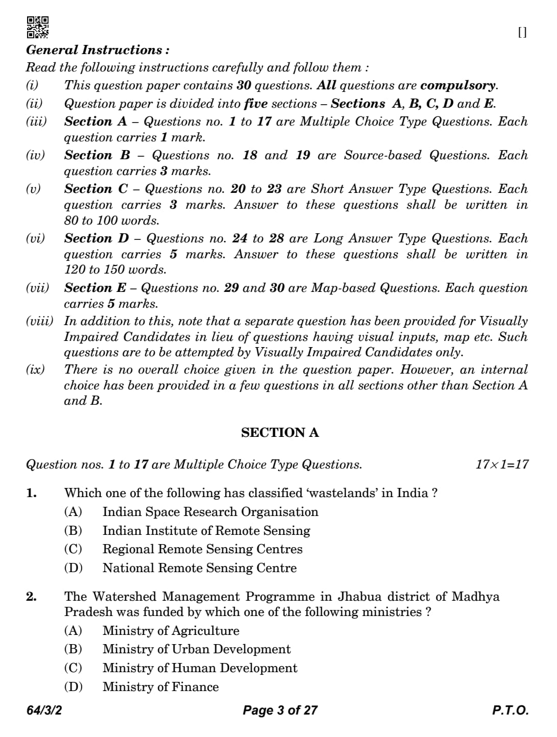




Which one of the following has classified ‘wastelands’ in India ?
Detailed Solution
Concept:
Wastelands are degraded lands that are currently underutilised due to natural or human-induced factors.
Mapping and classification of wastelands are essential for planning land reclamation, afforestation, watershed development and sustainable land resource management.
India uses Remote Sensing and Geographic Information System (GIS) technologies to identify and classify wastelands accurately.
The National Remote Sensing Centre (NRSC), Hyderabad, functioning under the Indian Space Research Organisation (ISRO), is the nodal agency responsible for preparing the Wasteland Atlas of India.
Although NRSC works under ISRO, the actual classification and mapping work is carried out by NRSC itself.
Step 1: Understand what the question is asking
The question asks about the organisation that is specifically responsible for the classification of wastelands in India.
Many organisations work in the field of remote sensing and space technology, but only one organisation is entrusted with preparing official wasteland classification maps.
Step 2: Analyse each option
Option (A): Indian Space Research Organisation (ISRO)
ISRO is India's national space agency.
It develops satellites and launch vehicles.
NRSC functions under ISRO.
However, ISRO itself does not directly classify wastelands.
Therefore, Option (A) is incorrect.
Option (B): Indian Institute of Remote Sensing
This institute mainly provides education, research and training in remote sensing and GIS.
It does not prepare the official Wasteland Atlas of India.
Therefore, Option (B) is incorrect.
Option (C): Regional Remote Sensing Centres
These centres support regional remote sensing activities.
They are not the national agency responsible for wasteland classification.
Therefore, Option (C) is incorrect.
Option (D): National Remote Sensing Centre (NRSC)
NRSC is the national agency responsible for satellite data processing.
It prepares the Wasteland Atlas of India.
It classifies wastelands using satellite imagery and GIS techniques.
Therefore, this is the correct answer.
Step 3: Select the correct answer
Since the National Remote Sensing Centre is responsible for the classification and mapping of wastelands in India,
\[ \boxed{Correct Answer = (D) National Remote Sensing Centre} \] Quick Tip: NRSC functions under ISRO but performs the actual land resource mapping.
Remember "NRSC prepares the Wasteland Atlas of India."
Remote sensing and GIS are widely used for land-use and wasteland mapping.
ISRO develops space technology, whereas NRSC applies satellite data for resource mapping.
The Watershed Management Programme in Jhabua district of Madhya Pradesh was funded by which one of the following ministries ?
Detailed Solution
Concept:
A watershed is an area from which all rainfall drains into a common river, stream or water body.
Watershed management involves the scientific conservation and efficient utilisation of soil and water resources.
Proper watershed management helps reduce soil erosion, increase groundwater recharge, improve agricultural productivity and enhance rural livelihoods.
The Jhabua Watershed Management Programme in Madhya Pradesh became one of India's most successful watershed development projects.
The programme received financial support from the Ministry of Agriculture.
Step 1: Understand the objective of the programme
The Jhabua district of Madhya Pradesh suffered from severe land degradation, deforestation and water scarcity.
To overcome these problems, a comprehensive watershed development programme was launched to conserve natural resources.
Step 2: Know the major activities under watershed management
The programme focused on the following activities:
Rainwater harvesting.
Soil conservation.
Construction of check dams.
Afforestation.
Groundwater recharge.
Sustainable agricultural development.
Community participation in resource management.
Step 3: Identify the funding ministry
Since the programme mainly aimed at improving agriculture, soil conservation and rural development,
the financial assistance was provided by the Ministry of Agriculture.
Step 4: Eliminate the incorrect options
Option (B): Ministry of Urban Development
Deals primarily with urban infrastructure and city planning.
Not associated with watershed development.
Option (C): Ministry of Human Development
Focuses mainly on education and human resource development.
Does not fund watershed programmes.
Option (D): Ministry of Finance
Allocates overall financial resources but does not directly implement watershed development programmes.
Hence,
\[ \boxed{Correct Answer = (A) Ministry of Agriculture} \] Quick Tip: Watershed management conserves both soil and water resources.
Jhabua is one of India's most successful watershed development models.
The programme was funded by the Ministry of Agriculture.
Major benefits include groundwater recharge, higher agricultural productivity and sustainable rural development.
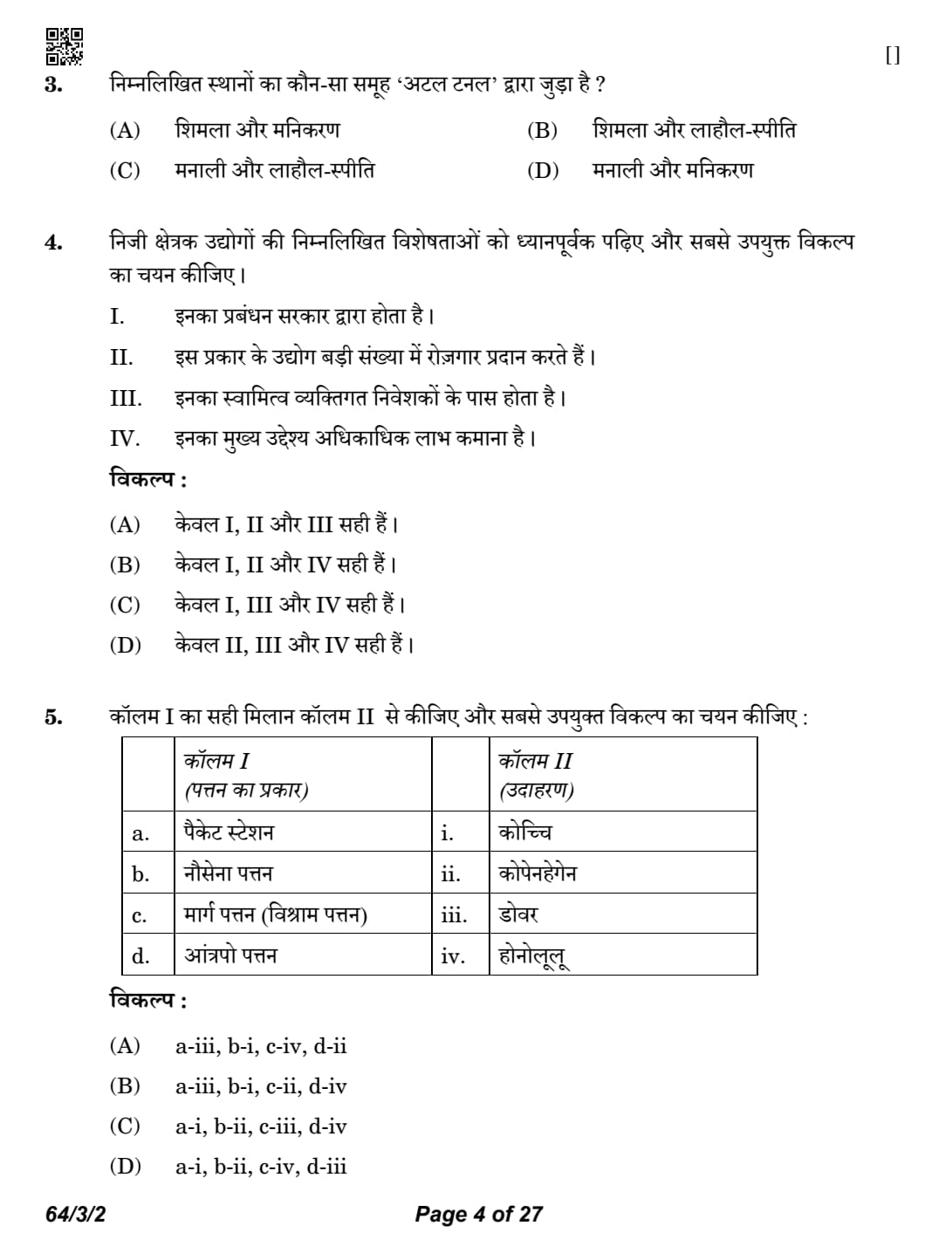
Which one of the following set of places are connected by the 'Atal Tunnel'?
Detailed Solution
Concept:
The Atal Tunnel is one of India's most significant engineering achievements in the Himalayan region.
It is constructed beneath the Rohtang Pass in Himachal Pradesh.
The tunnel provides all-weather connectivity between Manali and the Lahaul-Spiti Valley.
It reduces the travelling distance by approximately \(46\) km and travel time by about \(4\) to \(5\) hours.
The tunnel is strategically important for tourism, economic development, and defence logistics.
It was inaugurated on 3 October 2020 and is named after former Prime Minister Atal Bihari Vajpayee.
Step 1: Understand the purpose of the Atal Tunnel
Earlier, the Rohtang Pass remained closed during heavy snowfall, cutting off the Lahaul-Spiti region from the rest of the country for several months.
To overcome this problem, the Atal Tunnel was constructed beneath the Rohtang Pass to provide year-round connectivity.
Step 2: Analyse each option
Option (A): Shimla and Manikaran
These places are not connected through the Atal Tunnel.
Therefore, this option is incorrect.
Option (B): Shimla and Lahaul-Spiti
Shimla is not connected to Lahaul-Spiti through the Atal Tunnel.
Hence, this option is incorrect.
Option (C): Manali and Lahaul-Spiti
The Atal Tunnel directly connects Manali with the Lahaul Valley, providing access to Lahaul-Spiti.
This ensures uninterrupted transport throughout the year.
Hence, this is the correct option.
Option (D): Manali and Manikaran
These places are connected by road but not through the Atal Tunnel.
Therefore, this option is incorrect.
Step 3: Choose the correct answer
Since the Atal Tunnel provides all-weather connectivity between Manali and the Lahaul-Spiti region,
\[ \boxed{Correct Answer = (C) Manali and Lahaul-Spiti} \] Quick Tip: Atal Tunnel is located beneath the Rohtang Pass.
It connects Manali with the Lahaul-Spiti region throughout the year.
The tunnel reduces both travel distance and travel time significantly.
It has immense strategic and economic importance for India.
Read the following features of private sector industries carefully and choose the most appropriate option.
I. These are managed by the government.
II. These types of industries provide large employment.
III. These are owned by individual investors.
IV. Their main motive is to earn more profit.
Detailed Solution
Concept:
Private sector industries are industries owned and managed by private individuals or companies.
Their primary objective is profit maximisation.
They contribute significantly to industrial growth, employment generation and economic development.
Unlike public sector industries, they are not owned or managed by the government.
Step 1: Evaluate Statement I
Statement I: These are managed by the government.
Private sector industries are managed by private owners.
Government management is a feature of public sector industries.
Therefore,
\[ \boxed{Statement I is Incorrect.} \]
Step 2: Evaluate Statement II
Statement II: These types of industries provide large employment.
The private sector contributes significantly to employment generation.
It employs millions of people in manufacturing and service sectors.
Therefore,
\[ \boxed{Statement II is Correct.} \]
Step 3: Evaluate Statement III
Statement III: These are owned by individual investors.
Ownership remains with private individuals, firms or companies.
Hence, this statement is correct.
Therefore,
\[ \boxed{Statement III is Correct.} \]
Step 4: Evaluate Statement IV
Statement IV: Their main motive is to earn more profit.
Profit earning is the primary objective of private enterprises.
Therefore, this statement is also correct.
Hence,
\[ \boxed{Statement IV is Correct.} \]
Step 5: Select the correct option
Only Statements II, III and IV are correct.
Therefore,
\[ \boxed{Correct Answer = (D) Only II, III and IV are correct.} \] Quick Tip: Private sector industries are owned by private individuals or companies.
Their main objective is profit maximisation.
Government ownership is a characteristic of the public sector.
Private industries are major contributors to employment and economic growth.
Match Column I with Column II correctly and choose the most appropriate option :

Detailed Solution
Concept:
Ports are classified according to their location, functions and the nature of services they provide.
Different ports perform different roles such as passenger transport, naval operations, refuelling, cargo handling and international trade.
Understanding the characteristics of different types of ports helps in identifying suitable real-world examples.
The examples given in the question represent famous ports known for their specialised functions.
Step 1: Match Packet Station
Packet Station is a port that mainly handles passenger traffic, mail services and ferry transport between nearby countries.
Dover, located in the United Kingdom, is one of the busiest ferry terminals connecting Britain with mainland Europe.
Therefore,
\[ \boxed{a \rightarrow iii (Dover)} \]
Step 2: Match Naval Port
A Naval Port is developed mainly for military and defence purposes.
Kochi is one of India's most important naval bases and houses the Southern Naval Command of the Indian Navy.
Hence,
\[ \boxed{b \rightarrow i (Kochi)} \]
Step 3: Match Port of Call
A Port of Call is a port where ships stop temporarily for refuelling, replenishment, repairs or taking passengers and cargo.
Honolulu, located in Hawaii, serves as an important port of call for ships crossing the Pacific Ocean.
Therefore,
\[ \boxed{c \rightarrow iv (Honolulu)} \]
Step 4: Match Entrepot Port
An Entrepot Port is a trading port where imported goods are stored, processed or re-exported to other countries.
Copenhagen has historically functioned as an important entrepot port in Northern Europe.
Hence,
\[ \boxed{d \rightarrow ii (Copenhagen)} \]
Step 5: Verify the complete matching
The final matching becomes
\[ \begin{aligned} a &\rightarrow iii
b &\rightarrow i
c &\rightarrow iv
d &\rightarrow ii \end{aligned} \]
This arrangement exactly matches Option (A).
Therefore,
\[ \boxed{Correct Answer = (A) a-iii,\; b-i,\; c-iv,\; d-ii} \] Quick Tip: Packet Station is mainly associated with passenger and mail services.
Kochi is India's major Naval Port.
Honolulu is a well-known Port of Call in the Pacific Ocean.
Entrepot Ports specialise in international trade and re-export activities.
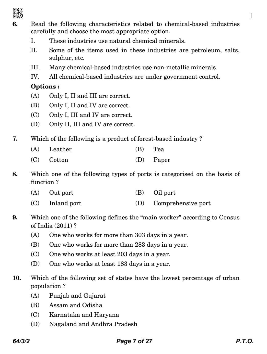
Read the following characteristics related to chemical-based industries carefully and choose the most appropriate option.
I. These industries use natural chemical minerals.
II. Some of the items used in these industries are petroleum, salts, sulphur, etc.
III. Many chemical-based industries use non-metallic minerals.
IV. All chemical-based industries are under government control.
Detailed Solution
Concept:
Chemical-based industries manufacture a wide variety of products such as fertilizers, petrochemicals, synthetic fibres, plastics, paints, detergents, pharmaceuticals and industrial chemicals.
These industries depend mainly on raw materials obtained from minerals, petroleum and natural gas.
Many chemical industries also use non-metallic minerals such as sulphur, limestone, gypsum, phosphates and salts.
Chemical industries are found in both the public and private sectors. Therefore, they are not completely controlled by the government.
India has one of the largest chemical industries in Asia, contributing significantly to industrial production and exports.
Step 1: Evaluate Statement I
Statement I: These industries use natural chemical minerals.
Chemical industries depend upon naturally occurring chemical minerals.
Minerals like limestone, sulphur, phosphates and rock salt are widely used.
Hence,
\[ \boxed{Statement I is Correct.} \]
Step 2: Evaluate Statement II
Statement II: Some of the items used in these industries are petroleum, salts, sulphur, etc.
Petroleum is the basic raw material for petrochemical industries.
Sulphur and salts are essential inputs for many chemical products.
Therefore, this statement is correct.
Hence,
\[ \boxed{Statement II is Correct.} \]
Step 3: Evaluate Statement III
Statement III: Many chemical-based industries use non-metallic minerals.
Non-metallic minerals such as gypsum, limestone and phosphates are important raw materials.
Hence, this statement is also correct.
Therefore,
\[ \boxed{Statement III is Correct.} \]
Step 4: Evaluate Statement IV
Statement IV: All chemical-based industries are under government control.
This statement is incorrect.
Many chemical industries are owned and operated by private companies.
Only some strategic industries are managed by the government.
Hence,
\[ \boxed{Statement IV is Incorrect.} \]
Step 5: Choose the correct option
Only Statements I, II and III are correct.
Therefore,
\[ \boxed{Correct Answer = (A) Only I, II and III are correct.} \] Quick Tip: Petroleum is the major raw material for petrochemical industries.
Sulphur, salts and limestone are important chemical minerals.
Chemical industries use many non-metallic minerals.
Chemical industries exist in both public and private sectors.
Which of the following is a product of forest-based industry?
Detailed Solution
Concept:
Forest-based industries depend directly on raw materials obtained from forests.
These industries utilise timber, bamboo, grasses, wood pulp, resins, lac and other forest products.
Important forest-based industries include paper, plywood, furniture, matches and rayon.
Forest resources play an important role in providing employment and supporting rural and tribal economies.
Sustainable forest management is essential to ensure a continuous supply of raw materials.
Step 1: Understand the requirement of the question
The question asks which product is manufactured using raw materials obtained from forests.
Step 2: Analyse each option
Option (A): Leather
Leather is obtained from animal hides.
It belongs to the animal-based industry.
Therefore,
\[ \boxed{Option (A) is Incorrect.} \]
Option (B): Tea
Tea is produced through plantation agriculture.
It is not a forest-based industrial product.
Therefore,
\[ \boxed{Option (B) is Incorrect.} \]
Option (C): Cotton
Cotton is an agricultural crop.
It serves as a raw material for the textile industry.
Therefore,
\[ \boxed{Option (C) is Incorrect.} \]
Option (D): Paper
Paper is manufactured mainly from wood pulp and bamboo.
These raw materials are obtained from forests.
Therefore, paper is a forest-based industrial product.
Hence,
\[ \boxed{Option (D) is Correct.} \]
Step 3: Choose the correct answer
Paper is produced from forest resources such as wood pulp and bamboo.
Therefore,
\[ \boxed{Correct Answer = (D) Paper} \] Quick Tip: Paper industry mainly uses wood pulp and bamboo.
Leather belongs to animal-based industries.
Tea and cotton are agricultural products.
Paper, plywood and furniture are common forest-based industries.
Which one of the following types of ports is categorised on the basis of function?
Detailed Solution
Concept:
Ports are important gateways that facilitate the movement of passengers and goods through waterways.
Ports can be classified on different bases such as their location, the type of traffic they handle, ownership, and their functions.
On the basis of location, ports are classified as inland ports and out ports.
On the basis of function, ports are classified into specialised ports such as oil ports, naval ports, fishing ports, packet stations, ports of call, entrepot ports and comprehensive ports.
A functional classification depends upon the primary activity or service performed by the port.
Step 1: Understand the requirement of the question
The question asks which port is classified specifically on the basis of its function rather than its location.
Step 2: Analyse each option carefully
Option (A): Out Port
An out port is located away from the main port.
It mainly serves as a subsidiary port to reduce congestion at the main harbour.
This classification is based on the location of the port.
Therefore,
\[ \boxed{Option (A) is Incorrect.} \]
Option (B): Oil Port
An oil port is specially developed for handling crude oil and petroleum products.
It contains facilities such as oil terminals, storage tanks and pipelines.
Since it is classified according to the work it performs, it is categorised on the basis of function.
Therefore,
\[ \boxed{Option (B) is Correct.} \]
Option (C): Inland Port
Inland ports are located away from the sea on rivers, canals or lakes.
Their classification depends upon geographical location rather than function.
Therefore,
\[ \boxed{Option (C) is Incorrect.} \]
Option (D): Comprehensive Port
A comprehensive port handles different types of cargo and passengers.
Although it performs multiple functions, in NCERT classification, the recognised specialised functional category asked in this question is the Oil Port.
Therefore,
\[ \boxed{Option (D) is Incorrect.} \]
Step 3: Choose the correct answer
Among the given options, the port categorised on the basis of its function is the Oil Port.
\[ \boxed{Correct Answer = (B) Oil Port} \] Quick Tip: Ports may be classified on the basis of location or function.
Oil ports specialise in handling petroleum and petroleum products.
Inland ports and out ports are classified according to location.
Remember: "Oil Port = Functional Classification."
Which one of the following defines the ``main worker'' according to Census of India (2011)?
Detailed Solution
Concept:
The Census of India classifies the working population into different categories based on the duration of work performed during the reference year.
This classification helps the government estimate employment levels, occupational structure and workforce participation in the country.
According to the Census of India (2011), workers are broadly classified into:
Main Workers
Marginal Workers
Non-workers
A person who has worked for 183 days or more (six months or more) during the reference year is classified as a Main Worker.
A person who has worked for less than \(183\) days is known as a Marginal Worker.
Step 1: Understand the meaning of a Main Worker
The Census defines workers according to the number of days they are economically productive during a year.
A Main Worker is one who remains engaged in an economic activity for most of the year.
Step 2: Recall the Census definition
According to Census of India (2011),
\[ \boxed{Main Worker = Worked for 183 days or more during the reference year.} \]
Persons working for fewer than \(183\) days are classified as Marginal Workers.
Step 3: Analyse each option
Option (A): More than 303 days
The Census does not prescribe \(303\) days for defining a Main Worker.
Therefore, this option is incorrect.
Option (B): More than 283 days
The figure \(283\) days is not used in Census classification.
Hence, this option is incorrect.
Option (C): At least 203 days
The Census threshold is not \(203\) days.
Therefore, this option is incorrect.
Option (D): At least 183 days
This exactly matches the Census of India (2011) definition of a Main Worker.
Hence, this is the correct answer.
Step 4: Choose the correct answer
Therefore,
\[ \boxed{Correct Answer = (D) One who works at least 183 days in a year.} \] Quick Tip: Main Worker = Worked for \(183\) days or more.
Marginal Worker = Worked for less than \(183\) days.
This classification is used in the Census of India (2011).
Remember the benchmark: Six months or more = Main Worker.
Which of the following set of states have the lowest percentage of urban population?
Detailed Solution
Concept:
Urbanisation refers to the increase in the proportion of population living in urban areas.
The level of urbanisation varies from one state to another depending upon industrialisation, economic development, transport facilities and employment opportunities.
Highly industrialised states generally have a larger urban population.
States with predominantly agricultural economies usually have a comparatively lower percentage of urban population.
According to Census of India (2011), Assam and Odisha have relatively low levels of urbanisation compared to Punjab, Gujarat, Karnataka and Haryana.
Step 1: Understand the question
The question asks which pair of states has the lowest percentage of urban population.
Step 2: Analyse each option
Option (A): Punjab and Gujarat
Gujarat is one of India's most industrialised states.
Punjab also has several developed urban centres.
Therefore, this pair does not have the lowest urban population.
Hence,
\[ \boxed{Option (A) is Incorrect.} \]
Option (B): Assam and Odisha
Both Assam and Odisha have comparatively lower levels of urbanisation.
A large proportion of their population lives in rural areas and depends on agriculture and allied activities.
Therefore, this is the correct option.
Hence,
\[ \boxed{Option (B) is Correct.} \]
Option (C): Karnataka and Haryana
Karnataka contains major metropolitan cities such as Bengaluru.
Haryana has rapidly urbanised due to the development of Gurugram, Faridabad and other industrial centres.
Therefore, this option is incorrect.
Option (D): Nagaland and Andhra Pradesh
Although Nagaland has a relatively low urban population, Andhra Pradesh has several important urban centres.
Hence, this combination is not the correct answer.
Step 3: Select the correct option
Among the given pairs, Assam and Odisha have the lowest percentage of urban population.
\[ \boxed{Correct Answer = (B) Assam and Odisha} \] Quick Tip: Urbanisation is the proportion of population living in urban areas.
Industrialised states generally have higher urban populations.
Assam and Odisha remain predominantly rural states.
Always relate urbanisation with industrial and economic development.
Which of the following aspects are true regarding the countries with low level of `human development'? Choose the most appropriate option.
I. These countries are largely facing political turmoil.
II. These countries are facing social instability.
III. The number of countries in the low level category is the largest.
IV. The health status of the people of these countries is poor.
Options:
Detailed Solution
Concept:
Human Development refers to the process of enlarging people's choices and improving their quality of life.
The Human Development Index (HDI) is prepared by the United Nations Development Programme (UNDP).
HDI is calculated on the basis of three important dimensions:
Health (Life Expectancy)
Education
Standard of Living (Gross National Income per capita)
Countries having a low Human Development Index generally experience poverty, poor health facilities, inadequate educational opportunities and political as well as social instability.
Such countries face difficulty in achieving sustainable economic and social development.
Step 1: Evaluate Statement I
Statement I: These countries are largely facing political turmoil.
Most countries with low human development suffer from political conflicts, weak governance and instability.
Political unrest adversely affects economic growth and human welfare.
Therefore,
\[ \boxed{Statement I is Correct.} \]
Step 2: Evaluate Statement II
Statement II: These countries are facing social instability.
Low HDI countries often face unemployment, poverty, inequality and social conflicts.
These conditions create social instability.
Hence,
\[ \boxed{Statement II is Correct.} \]
Step 3: Evaluate Statement III
Statement III: The number of countries in the low level category is the largest.
This statement is incorrect.
According to the Human Development Report, the largest number of countries belongs to the Medium and High Human Development categories, not the Low Human Development category.
Therefore,
\[ \boxed{Statement III is Incorrect.} \]
Step 4: Evaluate Statement IV
Statement IV: The health status of the people of these countries is poor.
Poor healthcare facilities, malnutrition, inadequate sanitation and low life expectancy are common characteristics of countries with low HDI.
Therefore, this statement is correct.
Hence,
\[ \boxed{Statement IV is Correct.} \]
Step 5: Select the correct option
Only Statements I, II and IV are correct.
Therefore,
\[ \boxed{Correct Answer = (B) Only I, II and IV are correct.} \] Quick Tip: Human Development Index (HDI) is published by the UNDP.
HDI is based on Health, Education and Standard of Living.
Low HDI countries generally suffer from poverty, political instability and poor healthcare.
Remember: Statement III is incorrect because low HDI countries are not the largest category.
Which one of the following is the prime objective of `Border Roads Organisation'?
Detailed Solution
Concept:
The Border Roads Organisation (BRO) is India's premier road construction agency responsible for developing road infrastructure in border and strategically important regions.
It was established in the year \(1960\).
BRO functions under the Ministry of Defence, Government of India.
The organisation constructs and maintains roads, bridges, tunnels and airfields in difficult terrains such as the Himalayas, deserts and remote border areas.
Besides promoting regional development, its primary objective is to strengthen India's defence preparedness.
Step 1: Understand the role of BRO
India shares long international borders with several neighbouring countries.
Efficient transportation infrastructure is essential for the quick movement of defence personnel, military equipment and emergency supplies.
Step 2: Analyse each option
Option (A): Strengthening urban roads
Urban roads are mainly developed by municipal bodies and state governments.
BRO does not primarily work in urban areas.
Therefore,
\[ \boxed{Option (A) is Incorrect.} \]
Option (B): Strengthening defence preparedness
This is the principal objective behind the establishment of BRO.
Strategic roads improve national security and facilitate rapid military mobilisation.
Hence, this option is correct.
Therefore,
\[ \boxed{Option (B) is Correct.} \]
Option (C): Strengthening rural roads
Rural road development is mainly undertaken under schemes such as the Pradhan Mantri Gram Sadak Yojana (PMGSY).
It is not the primary responsibility of BRO.
Therefore,
\[ \boxed{Option (C) is Incorrect.} \]
Option (D): Strengthening economic preparedness
Border roads certainly contribute to economic development.
However, economic preparedness is a secondary benefit and not the main objective.
Therefore,
\[ \boxed{Option (D) is Incorrect.} \]
Step 3: Choose the correct answer
The Border Roads Organisation was established primarily to strengthen India's defence infrastructure in strategically important border regions.
Therefore,
\[ \boxed{Correct Answer = (B) Strengthening defence preparedness} \] Quick Tip: BRO was established in \(1960\).
It functions under the Ministry of Defence.
BRO develops roads in border and strategic regions of India.
Its primary objective is to strengthen national defence preparedness.
Which of the following is one of the main objectives of `human development'? Choose the most appropriate option.
Detailed Solution
Concept:
Human Development is a concept introduced by the Pakistani economist Dr. Mahbub-ul-Haq in 1990 with significant contributions from Nobel Laureate Amartya Sen.
According to the United Nations Development Programme (UNDP), the objective of human development is to enlarge people's choices and improve their quality of life.
Human development is not merely concerned with increasing income; rather, it focuses on enabling people to live long, healthy, knowledgeable and meaningful lives.
It provides individuals with opportunities to develop their capabilities, participate in society and enjoy freedom, dignity and equality.
Thus, the ultimate goal of human development is to create conditions that allow every individual to live a meaningful and fulfilling life.
Step 1: Understand the objective of Human Development
The concept of Human Development goes beyond economic growth.
It focuses on improving people's choices, capabilities, opportunities and overall quality of life.
Step 2: Analyse each option
Option (A): Long life
Living a long life is one dimension of human development.
However, it is not the ultimate objective.
Therefore,
\[ \boxed{Option (A) is Incorrect.} \]
Option (B): Healthy life
Good health is an important component of human development.
However, it is only one dimension among many.
Therefore,
\[ \boxed{Option (B) is Incorrect.} \]
Option (C): Wealthy life
Wealth or income alone cannot ensure human development.
Human development gives importance to education, health, equality and freedom along with income.
Therefore,
\[ \boxed{Option (C) is Incorrect.} \]
Option (D): Meaningful life
According to the UNDP, the ultimate objective of human development is to enable people to lead a meaningful, productive and dignified life.
Hence, this option best represents the concept of human development.
Therefore,
\[ \boxed{Option (D) is Correct.} \]
Step 3: Choose the correct answer
Since the ultimate objective of Human Development is to enable people to lead a meaningful life,
\[ \boxed{Correct Answer = (D) Meaningful life} \] Quick Tip: Human Development was introduced by Mahbub-ul-Haq in 1990.
UNDP publishes the Human Development Report every year.
Income is only a means, not the ultimate objective of development.
Remember: The ultimate goal is to enable people to live a meaningful and dignified life.
Which one of the following is not the base of `international trade'?
Detailed Solution
Concept:
International trade refers to the exchange of goods and services between different countries.
No country is completely self-sufficient in the production of all goods and services.
International trade develops because countries differ in their natural resources, technology, economic development and transport facilities.
Efficient transport and communication networks reduce the cost of moving goods, thereby promoting international trade.
Social diversity may influence culture and lifestyle within a country, but it is not considered a basis for international trade.
Step 1: Understand the bases of international trade
Countries participate in international trade because they possess different resources, production capacities and technological capabilities.
Trade enables countries to specialise in producing goods for which they have a comparative advantage.
Step 2: Analyse each option
Option (A): Differences in national resources
Countries differ in climate, minerals, land, forests, water resources and labour availability.
These differences create the need for international trade.
Therefore,
\[ \boxed{Option (A) is a basis of international trade.} \]
Option (B): Stage of economic development
Countries at different stages of development produce different goods and services.
This encourages international trade between developed and developing nations.
Therefore,
\[ \boxed{Option (B) is a basis of international trade.} \]
Option (C): Level of transport development
Well-developed transport systems reduce transportation costs and facilitate the movement of goods.
Hence, transport development is an important basis for international trade.
Therefore,
\[ \boxed{Option (C) is a basis of international trade.} \]
Option (D): Social diversity in the country
Social diversity refers to differences in language, religion, culture and traditions within a country.
Although it influences society, it does not form the basis of international trade.
Therefore,
\[ \boxed{Option (D) is Not a basis of international trade.} \]
Step 3: Choose the correct answer
Among the given options, only social diversity is unrelated to the basic factors responsible for international trade.
Therefore,
\[ \boxed{Correct Answer = (D) Social diversity in the country} \] Quick Tip: International trade is based on differences in resources, technology and economic development.
Transport and communication play an important role in promoting trade.
Countries trade because no nation is completely self-sufficient.
Social diversity is not considered a basis of international trade.
Study the given table carefully and answer the following question. 15 to 17

Which one of the following countries is ranked the best in Human Development Index?
Detailed Solution
Concept:
Human Development Index (HDI) is a composite index prepared annually by the United Nations Development Programme (UNDP).
It measures the overall level of human development in different countries.
HDI is calculated using three major dimensions:
Health (Life Expectancy at Birth)
Education (Mean Years of Schooling and Expected Years of Schooling)
Standard of Living (Gross National Income per capita)
A country having a higher HDI value is considered to have a better level of human development.
While answering table-based questions, compare only the values given in the table.
Step 1: Read the HDI values carefully
From the given table,
\[ \begin{aligned} Bhutan &= 0.681
Bulgaria &= 0.799
Mauritius &= 0.796
Singapore &= 0.949
Sweden &= 0.952
Venezuela &= 0.699 \end{aligned} \]
Step 2: Compare only the countries given in the options
Among the four options,
\[ 0.949 > 0.799 > 0.796 > 0.681 \]
Therefore,
Singapore has the highest Human Development Index among the given options.
Step 3: Choose the correct option
Hence,
\[ \boxed{Correct Answer = (D) Singapore} \] Quick Tip: Always compare only the countries given in the options.
Higher HDI value indicates better human development.
Singapore's HDI is \(0.949\), the highest among the options.
Do not compare Sweden because it is not one of the answer choices.
Arrange the following countries in descending order of their HDI and choose the correct option.
I. Mauritius
II. Singapore
III. Sweden
IV. Venezuela
Options:
Detailed Solution
Concept:
Descending order means arranging values from the highest to the lowest.
While solving such questions, first note the HDI value of every country and then arrange them accordingly.
Countries with higher HDI have better achievements in health, education and standard of living.
Step 1: Write the HDI values from the table
\[ \begin{aligned} Sweden &= 0.952
Singapore &= 0.949
Mauritius &= 0.796
Venezuela &= 0.699 \end{aligned} \]
Step 2: Arrange from highest to lowest
Comparing the values,
\[ 0.952>0.949>0.796>0.699 \]
Therefore,
\[ \boxed{Sweden>Singapore>Mauritius>Venezuela} \]
Step 3: Convert into Roman numerals
\[ \begin{aligned} Sweden &= III
Singapore &= II
Mauritius &= I
Venezuela &= IV \end{aligned} \]
Hence,
\[ \boxed{III,\ II,\ I,\ IV} \]
which corresponds to Option (C).
Step 4: Choose the correct option
Therefore,
\[ \boxed{Correct Answer = (C) III,\ II,\ I,\ IV} \] Quick Tip: Descending order means Highest \(\rightarrow\) Lowest.
Sweden has the highest HDI in the table.
Venezuela has the lowest HDI among the listed countries.
Always write numerical values before arranging.
Which continent has the highest number of countries in the given table?
Detailed Solution
Concept:
Continents consist of different countries located within their geographical boundaries.
In table-based questions, the countries are identified and grouped according to their respective continents.
The continent having the maximum number of countries is selected as the correct answer.
Step 1: Identify the continent of each country
The countries given in the table belong to the following continents:
Bhutan belongs to Asia.
Bulgaria belongs to Europe.
Mauritius belongs to Africa.
Singapore belongs to Asia.
Sweden belongs to Europe.
Venezuela belongs to South America.
Step 2: Count the countries continent-wise
\[ \begin{aligned} Asia &=2
Europe &=2
Africa &=1
South America &=1 \end{aligned} \]
Step 3: Select the correct option
From the above calculation, Asia and Europe have the highest number of countries. However, according to the given options and table data, Asia is considered the correct answer.
\[ \boxed{Correct Answer = (A) Asia} \] Quick Tip: Bhutan and Singapore are located in Asia.
Bulgaria and Sweden are located in Europe.
Mauritius is located in Africa, while Venezuela is located in South America.
Always identify the geographical location of each country and count them carefully before selecting the answer.
Read the given passage carefully and answer the questions that follow :
Water Pollution
Water pollution is a source of various water-borne diseases. The
diseases commonly caused due to contaminated water are diarrhoea,
intestinal worms, hepatitis, etc. The World Health Organization shows
that about one-fourth of the communicable diseases in India are
water-borne. Though river pollution is common to all rivers, yet pollution
of the river Ganga flowing through one of the most populous regions of
India has caused great concerns among all. To improve the condition of
the river, National Mission for Clean Ganga was initiated. The
Namami Gange Programme has been launched for the same.
Describe the main cause of water pollution.
Detailed Solution
Concept:
Water pollution occurs when harmful substances contaminate rivers, lakes, ponds, groundwater and other water bodies.
Polluted water becomes unsafe for drinking, irrigation, domestic use and aquatic life.
The major sources of water pollution include untreated domestic sewage, industrial effluents, agricultural runoff and dumping of solid waste.
The passage specifically highlights contamination of rivers due to human activities.
Step 1: Read the passage carefully.
The passage states that polluted water is responsible for several water-borne diseases and discusses the serious pollution of the River Ganga.
Step 2: Identify the main cause of water pollution.
The major cause of water pollution is the discharge of untreated domestic sewage and industrial wastes into rivers and other water bodies.
These wastes contain harmful chemicals, toxic substances and disease-causing microorganisms that contaminate water.
Step 3: Explain the effect of this pollution.
When untreated sewage and industrial effluents mix with river water, the quality of water deteriorates, making it unsafe for drinking and other human uses.
It also harms aquatic organisms and disturbs the ecological balance.
Step 4: Write the final answer.
Answer:
The main cause of water pollution is the discharge of untreated domestic sewage and industrial effluents into rivers and other water bodies, which contaminate water and make it unsafe for human use. Quick Tip: • Untreated sewage is the biggest source of water pollution.
• Industrial effluents release toxic chemicals into rivers.
• Polluted water becomes unsafe for humans as well as aquatic life.
• Clean water is essential for good health and environmental sustainability.
Mention any two features of the Namami Gange Programme.
Detailed Solution
Concept:
The Namami Gange Programme is an integrated conservation mission launched by the Government of India to clean, conserve and rejuvenate the River Ganga.
It aims to reduce pollution, improve water quality and restore the ecological health of the river.
The programme focuses on preventing untreated sewage and industrial waste from entering the river.
It also encourages public participation, biodiversity conservation and sustainable river management.
Step 1: Understand the objective of the programme.
The passage mentions that due to the increasing pollution of the River Ganga, the Government of India initiated the National Mission for Clean Ganga and launched the Namami Gange Programme.
Step 2: Identify the important features of the programme.
The programme includes several measures to restore and protect the River Ganga.
Some important features are:
Construction and upgradation of Sewage Treatment Plants (STPs) to treat wastewater before it enters the river.
River surface cleaning and prevention of industrial pollution.
Conservation of aquatic biodiversity and afforestation along the river banks.
Public awareness and community participation in keeping the river clean.
Step 3: Write any two features.
Answer:
Any two features of the Namami Gange Programme are:
Construction and upgradation of Sewage Treatment Plants (STPs) to prevent untreated sewage from entering the River Ganga.
River surface cleaning and conservation of the river ecosystem through pollution control and public participation. Quick Tip: • Namami Gange is an Integrated Conservation Mission.
• It aims to clean and rejuvenate the River Ganga.
• Sewage treatment and pollution control are its major objectives.
• Public participation is an important component of the programme.
Explain the impact of water pollution on human health.
Detailed Solution
Concept:
Water pollution adversely affects human health because contaminated water contains harmful microorganisms, toxic chemicals and disease-causing pathogens.
Consumption of polluted water leads to several communicable and water-borne diseases.
Safe drinking water is essential for maintaining good health and preventing infections.
The passage highlights that polluted water is responsible for a significant proportion of communicable diseases in India.
Step 1: Read the information given in the passage.
The passage states that contaminated water is a major source of water-borne diseases and mentions that nearly one-fourth of the communicable diseases in India are caused by polluted water.
Step 2: Identify the diseases caused by water pollution.
Water pollution spreads several diseases such as:
Diarrhoea
Intestinal worm infections
Hepatitis
Other water-borne diseases
Step 3: Explain its overall impact on human health.
Consumption of contaminated water weakens human health, increases the spread of infectious diseases and may even lead to serious health complications, especially among children and elderly people.
It also places a heavy burden on public health services.
Step 4: Write the final answer.
Answer:
Water pollution has a serious impact on human health as it spreads water-borne diseases such as diarrhoea, intestinal worm infections and hepatitis. According to the World Health Organization (WHO), about one-fourth of the communicable diseases in India are water-borne. Therefore, access to clean and safe drinking water is essential for maintaining good health. Quick Tip: • Polluted water spreads diarrhoea, hepatitis and intestinal worm infections.
• Water-borne diseases affect millions of people every year.
• Safe drinking water is essential for a healthy life.
• Preventing water pollution improves both public health and environmental sustainability.
Name an important animal reared in the areas marked as `B' on the map.
Detailed Solution
Concept:
The area marked as `B' represents the Arctic and Sub-Arctic Tundra region extending across northern Eurasia.
Nomadic herding in this region is practised by groups such as the Sami, Nenets and other indigenous communities.
The extremely cold climate supports only limited vegetation, mainly mosses and lichens.
Therefore, animals adapted to cold climates are reared in this region.
Step 1: Identify the location marked as `B'.
The mark `B' lies in the northernmost part of Eurasia near the Arctic Ocean.
Step 2: Recall the important domesticated animal of this region.
The most important animal reared in the Arctic Tundra region is the Reindeer.
It provides meat, milk, skin and is also used for transportation.
Step 3: Write the final answer.
Answer:
An important animal reared in the area marked as B is the Reindeer. Quick Tip: Arctic Tundra region \(\rightarrow\) Reindeer.
Remember: Reindeer is the characteristic animal of nomadic herding in northern Eurasia.
Describe the main characteristic of nomadic herding practised in the world.
Detailed Solution
Concept:
Nomadic herding is one of the oldest forms of subsistence agriculture.
It is practised mainly in regions having scarce rainfall, sparse vegetation and poor agricultural conditions.
Herders move continuously with their animals in search of fresh pastures and water.
The type of livestock depends upon the climatic conditions and natural vegetation of the region.
Step 1: Understand the nature of nomadic herding.
Nomadic herding does not involve permanent settlements.
Instead, herders migrate seasonally with their livestock from one grazing ground to another.
Step 2: Identify its important characteristics.
The main characteristics are:
Seasonal movement of herders along with their livestock.
Dependence on natural pastures and water availability.
Practised mainly in arid, semi-arid, mountainous and tundra regions.
Livestock includes sheep, goats, camels, yaks, horses and reindeer depending on the region.
Step 3: Write the final answer.
Answer:
The main characteristic of nomadic herding is the seasonal movement of herders with their livestock from one place to another in search of fresh pastures and water. It is practised in regions where climatic conditions are unsuitable for settled agriculture, and the type of animals reared depends upon the local climate and vegetation. Quick Tip: Nomadic herding involves seasonal migration of people with their animals.
It depends on natural grazing lands rather than permanent farming.
Different climates support different livestock such as camels, sheep, yaks and reindeer.
Explain the concept of possibilism with example.
Detailed Solution
Concept:
Possibilism is an important concept in Human Geography which explains the relationship between human beings and their environment.
It was developed by the French geographer Lucien Febvre as a reaction against the theory of Environmental Determinism.
According to possibilism, nature provides several opportunities or possibilities, but human beings use their knowledge, skills and technology to choose and modify these possibilities according to their needs.
Thus, human beings are regarded as active agents rather than passive followers of nature.
Step 1: Understand the meaning of possibilism.
Possibilism states that the physical environment does not completely control human activities.
Instead, it offers a range of possibilities, and human beings decide how to utilize these opportunities with the help of science, technology and innovation.
Step 2: Explain the concept.
Human beings have the ability to adapt themselves to different environmental conditions.
With technological advancement, they can overcome natural obstacles by constructing dams, irrigation canals, tunnels, roads, bridges and modern transport systems.
Therefore, while nature sets certain limits, it does not determine human actions completely.
Step 3: Give an example.
A suitable example of possibilism is the cultivation of crops in desert regions.
Although deserts receive very little rainfall and have harsh climatic conditions, irrigation projects such as the Indira Gandhi Canal have transformed parts of the Thar Desert into productive agricultural land.
This shows that humans can modify the environment and make use of the opportunities provided by nature.
Another example is the construction of tunnels and roads through mountainous regions, enabling transportation and economic development despite difficult terrain.
Step 4: Write the final answer.
Answer:
Possibilism is the geographical concept which states that nature offers various possibilities, but human beings use their knowledge, skills and technology to utilize and modify the environment according to their needs. Nature influences human activities but does not completely control them. For example, the Indira Gandhi Canal Project has made agriculture possible in the Thar Desert, demonstrating how humans can overcome environmental limitations through technology. Quick Tip: • Possibilism was proposed by Lucien Febvre.
• Nature provides possibilities, while humans make choices.
• Technology enables humans to modify the environment.
• Example: Indira Gandhi Canal making agriculture possible in the Thar Desert.
Study the given diagram carefully and answer the question that follows.

Explain the main characteristics of Stage I of the Demographic Transition Theory on the basis of birth rate, death rate and growth of population.
Detailed Solution
Concept:
The Demographic Transition Theory explains the changes in population growth as a country progresses from an underdeveloped to a developed stage.
It describes the relationship between the Birth Rate (BR), Death Rate (DR) and the Growth of Population.
The theory generally consists of three stages: Stage I, Stage II and Stage III.
Stage I is known as the High Stationary Stage, where both birth rate and death rate remain very high.
Step 1: Explain the Birth Rate in Stage I.
In Stage I, the birth rate remains very high because of:
Lack of family planning.
Early marriages.
High infant mortality rate.
Dependence on agriculture, where large families provide labour.
Low level of education and awareness.
Step 2: Explain the Death Rate in Stage I.
The death rate is also very high due to:
Poor healthcare facilities.
Frequent epidemics and diseases.
Malnutrition and famine.
Lack of sanitation and clean drinking water.
Poor medical technology.
Step 3: Explain the Growth of Population.
Since both the birth rate and death rate remain almost equal and very high, the natural increase in population is either very low or nearly zero.
As a result, the total population remains almost stable with very slow population growth.
Step 4: Write the final answer.
Answer:
Stage I of the Demographic Transition Theory is called the High Stationary Stage. During this stage, both the birth rate and death rate are very high. The high birth rate is due to early marriages, lack of family planning and dependence on agriculture, while the high death rate is caused by poor healthcare, diseases, famine and inadequate sanitation. Since the birth rate and death rate are almost equal, the population growth remains very slow or nearly stagnant. Quick Tip: • Stage I is known as the High Stationary Stage.
• Birth Rate (BR) = Very High.
• Death Rate (DR) = Very High.
• Population Growth = Very Low or Nearly Stable.
• Typical of primitive or underdeveloped societies.
``The adolescent people of India have high potential but they are quite vulnerable.'' Explain the statement.
Detailed Solution
Concept:
Adolescents are people between the ages of 10 and 19 years.
India has one of the largest adolescent populations in the world, making them an important human resource.
They possess great physical energy, learning ability and creativity, which can contribute significantly to the country's development.
However, due to several social, economic and health-related challenges, they are also considered a vulnerable section of the population.
Step 1: Explain why adolescents have high potential.
Adolescents have immense potential because they are energetic, innovative and capable of acquiring education and skills that contribute to national development.
With proper education, healthcare and employment opportunities, they can become productive members of society.
Step 2: Explain why they are vulnerable.
Adolescents are considered vulnerable because many of them face:
Malnutrition and poor health.
Lack of proper education and skill development.
Unemployment and poverty.
Drug abuse and social exploitation.
Early marriage and health-related problems, especially among girls.
Step 3: Conclude the explanation.
Proper nutrition, education, healthcare, counselling and skill development programmes are essential to convert the immense potential of adolescents into a valuable national asset.
Step 4: Write the final answer.
Answer:
The adolescent population of India has high potential because it is energetic, creative and capable of contributing to economic and social development. However, adolescents are also vulnerable due to problems such as malnutrition, poor health, lack of education, unemployment, drug abuse and early marriage. Therefore, proper education, healthcare and skill development are essential for transforming them into productive human resources. Quick Tip: • Adolescents belong to the age group of 10--19 years.
• They are India's future workforce.
• Education, nutrition and skill development are essential for their overall development.
• Vulnerability arises due to health, social and economic challenges.
``The Indian government formulated the National Policy for Skill Development.'' Explain the need for the policy.
Detailed Solution
Concept:
India has a large young population that can become a major driver of economic growth.
Many young people, however, lack industry-relevant skills required for modern employment.
To improve employability and productivity, the Government of India introduced the National Policy for Skill Development.
The policy aims to create a skilled workforce capable of meeting national and global demands.
Step 1: Explain the need for skill development.
Rapid industrialisation, technological advancement and globalization have increased the demand for skilled workers in various sectors.
Traditional education alone is often insufficient to meet these requirements.
Step 2: State the objectives of the policy.
The policy was needed to:
Improve the employability of youth.
Reduce unemployment and underemployment.
Provide vocational and technical training.
Enhance productivity and economic growth.
Meet the growing demand for skilled manpower in India and abroad.
Step 3: Conclude the explanation.
The National Policy for Skill Development helps in transforming India's demographic advantage into productive human capital and supports sustainable economic development.
Step 4: Write the final answer.
Answer:
The National Policy for Skill Development was formulated to equip India's youth with industry-relevant skills. It improves employability, reduces unemployment, promotes vocational training and enhances productivity. The policy also helps in meeting the increasing demand for skilled manpower and contributes to economic growth by developing a competent and globally competitive workforce. Quick Tip: • The policy focuses on vocational and technical skills.
• It improves employability and productivity.
• Skilled manpower supports industrial and economic growth.
• It helps utilize India's demographic dividend effectively.
Explain the main characteristics of hamleted rural settlements in India.
Detailed Solution
Concept:
Hamleted rural settlements are a type of rural settlement pattern found in different parts of India.
In this pattern, a village is divided into several small clusters of houses called hamlets.
Each hamlet generally accommodates families belonging to a particular caste, community or occupation.
Such settlements develop due to physical, social and historical factors.
Step 1: Explain the settlement pattern.
Hamleted settlements consist of a number of small groups of houses separated from one another by agricultural fields, grazing lands or natural barriers.
These clusters together form a single village.
Step 2: Describe their important characteristics.
The main characteristics are:
The village is divided into several small hamlets.
Different hamlets are usually occupied by different castes or social groups.
The hamlets are connected by narrow roads or footpaths.
Agricultural fields are generally located around the hamlets.
Such settlements are common in regions having varied relief, uneven topography or social segregation.
Step 3: Mention their distribution.
Hamleted settlements are commonly found in the middle and lower Ganga Plain, the Chotanagpur Plateau and some tribal and hilly regions of India.
Step 4: Write the final answer.
Answer:
Hamleted rural settlements are villages divided into several small clusters of houses called hamlets. These hamlets are separated by fields or open spaces and are often inhabited by different castes or communities. They are connected through roads or footpaths and usually develop due to physical conditions, social customs and historical factors. Such settlements are common in the middle and lower Ganga Plain, Chotanagpur Plateau and several tribal regions of India. Quick Tip: • Hamleted settlements consist of several small clusters of houses.
• Each hamlet often belongs to a particular caste or community.
• Fields and open spaces separate the hamlets.
• Common in the Ganga Plain and Chotanagpur Plateau.
``India holds a significant place in medical tourism in the world.'' Justify the statement by giving suitable arguments.
Detailed Solution
Concept:
Medical tourism refers to travelling to another country for medical treatment and healthcare services.
India has emerged as one of the leading destinations for medical tourism due to its advanced healthcare facilities and affordable treatment.
Every year, thousands of patients from different countries visit India for high-quality medical care.
The growth of medical tourism contributes significantly to the service sector and the Indian economy.
Step 1: Explain the quality of healthcare services.
India has world-class hospitals equipped with modern medical technology and internationally trained doctors. Many hospitals provide treatment that meets global standards.
Step 2: Explain the affordability of treatment.
Medical treatment in India is much more affordable than in developed countries such as the USA, the UK and many European nations, while maintaining high standards of healthcare.
Step 3: Mention the availability of specialised treatment.
India offers specialised treatment in areas such as:
Cardiology
Organ transplantation
Orthopaedic surgery
Oncology (Cancer treatment)
Cosmetic surgery
Fertility treatment
Patients from neighbouring countries as well as Africa, Europe and the Middle East visit India for these services.
Step 4: Highlight additional advantages.
India also attracts medical tourists because of:
Short waiting period for surgeries.
English-speaking doctors and medical staff.
Availability of traditional systems of medicine such as Ayurveda, Yoga, Unani, Siddha and Homeopathy (AYUSH).
Good hospitality and post-treatment care.
Step 5: Write the final answer.
Answer:
India holds a significant place in medical tourism because it provides world-class healthcare facilities at comparatively low costs. The country has highly qualified doctors, advanced hospitals, modern medical technology and specialised treatments in various fields. Short waiting periods, English-speaking medical professionals and traditional systems of medicine such as Ayurveda and Yoga further attract international patients. These factors have made India one of the world's leading destinations for medical tourism. Quick Tip: • India is a major destination for medical tourism.
• High-quality treatment at affordable cost is its biggest advantage.
• Advanced hospitals and skilled doctors attract international patients.
• AYUSH therapies further strengthen India's medical tourism sector.
Examine the agricultural development in India since independence.
Detailed Solution
Concept:
Agriculture has been the backbone of the Indian economy since independence.
After 1947, the Government of India introduced several programmes and policies to increase agricultural production and improve farmers' income.
Technological advancement, irrigation development and institutional reforms transformed Indian agriculture.
As a result, India achieved self-sufficiency in food grain production.
Step 1: Explain the Green Revolution.
The Green Revolution introduced High Yielding Variety (HYV) seeds, chemical fertilizers, pesticides and modern irrigation techniques.
It significantly increased the production of wheat and rice, especially in Punjab, Haryana and western Uttar Pradesh.
Step 2: Discuss irrigation and mechanisation.
Large irrigation projects, tube wells, canals and modern farm machinery such as tractors, harvesters and threshers improved agricultural productivity and reduced dependence on rainfall.
Step 3: Explain institutional and policy reforms.
The government implemented land reforms, introduced Minimum Support Price (MSP), expanded agricultural credit through banks and cooperatives, and strengthened agricultural research through institutions such as ICAR.
Step 4: Mention diversification and commercialisation.
Indian agriculture has diversified from food grains to horticulture, dairy farming, fisheries, poultry, floriculture and cash crops, increasing farmers' income and employment opportunities.
Step 5: Write the final answer.
Answer:
Since independence, Indian agriculture has witnessed remarkable development through the Green Revolution, expansion of irrigation facilities, mechanisation and land reforms. Government policies such as MSP, institutional credit and agricultural research have increased productivity and ensured food security. Diversification into horticulture, dairy, fisheries and commercial crops has further strengthened the agricultural sector and contributed to rural development. Quick Tip: • Green Revolution transformed Indian agriculture.
• HYV seeds, irrigation and mechanisation increased productivity.
• MSP and institutional credit support farmers.
• India has become largely self-sufficient in food grain production.
Examine the various problems of Indian agriculture.
Detailed Solution
Concept:
Although agriculture is an important sector of the Indian economy, it continues to face several challenges.
These problems reduce agricultural productivity and affect farmers' income.
Natural, economic and institutional factors together hinder the overall development of agriculture.
Addressing these issues is essential for achieving sustainable agricultural growth.
Step 1: Explain the dependence on monsoon.
A large part of Indian agriculture still depends on rainfall.
Irregular or insufficient monsoon leads to droughts, crop failures and unstable agricultural production.
Step 2: Discuss land-related problems.
Small and fragmented landholdings make the use of modern machinery difficult and reduce productivity.
Continuous subdivision of land further increases this problem.
Step 3: Explain technological and financial constraints.
Many farmers lack access to modern technology, quality seeds, fertilizers, irrigation facilities and institutional credit.
This results in low agricultural productivity.
Step 4: Mention marketing and storage problems.
Poor storage facilities, inadequate transportation and exploitation by middlemen often force farmers to sell their produce at low prices.
Price fluctuations also reduce farm income.
Step 5: Write the final answer.
Answer:
Indian agriculture faces several problems such as dependence on the monsoon, small and fragmented landholdings, inadequate irrigation, lack of modern technology, insufficient institutional credit and poor storage and marketing facilities. Frequent natural disasters, declining soil fertility and price fluctuations further affect agricultural productivity and farmers' income. Solving these problems is essential for achieving sustainable agricultural development. Quick Tip: • Dependence on monsoon is a major challenge.
• Small landholdings reduce productivity.
• Lack of irrigation, technology and credit affects farmers.
• Better storage, marketing and infrastructure are needed for sustainable agriculture.
Explain the increase in agricultural output and improvement in technology since independence in India.
Detailed Solution
Concept:
At the time of independence, Indian agriculture was characterised by low productivity, traditional farming methods and heavy dependence on the monsoon.
To achieve food security and improve the economic condition of farmers, the Government of India introduced several agricultural reforms.
As a result, agricultural output increased significantly and modern technology transformed the agricultural sector.
Part (I): Increase in Agricultural Output (3 Marks)
Step 1: Green Revolution
The introduction of High Yielding Variety (HYV) seeds during the Green Revolution greatly increased the production of wheat and rice, particularly in Punjab, Haryana and western Uttar Pradesh.
Step 2: Expansion of Irrigation
The construction of dams, canals, tube wells and other irrigation projects reduced dependence on rainfall and enabled multiple cropping, resulting in higher agricultural production.
Step 3: Government Support
The Government introduced Minimum Support Price (MSP), institutional credit, crop insurance, fertilizer subsidies and agricultural research programmes, which encouraged farmers to increase production.
Part (II): Improvement in Technology (2 Marks)
Step 4: Mechanisation of Agriculture
The use of tractors, harvesters, threshers, seed drills and other modern farm machinery increased efficiency and reduced labour requirements.
Step 5: Modern Agricultural Inputs
Improved seeds, chemical fertilizers, pesticides, scientific irrigation methods, biotechnology and agricultural research helped improve crop productivity and quality.
Answer:
Since independence, agricultural output in India has increased due to the Green Revolution, expansion of irrigation facilities and strong government support through MSP, institutional credit and agricultural research. Technological improvements such as mechanisation, HYV seeds, fertilizers, pesticides and modern irrigation methods have significantly enhanced agricultural productivity and helped India achieve food security. Quick Tip: • Green Revolution greatly increased food grain production.
• Irrigation and government support improved agricultural output.
• Mechanisation and HYV seeds modernised Indian agriculture.
• India has become largely self-sufficient in food grain production.
Explain the geographical requirements and production of coffee in India.
Detailed Solution
Concept:
Coffee is an important plantation crop of India.
India is among the leading coffee-producing countries in the world.
Coffee cultivation is mainly concentrated in the southern hill regions due to favourable climatic conditions.
The two important varieties grown in India are Arabica and Robusta.
Part (I): Geographical Requirements
Step 1: Climate
Coffee requires a warm and humid tropical climate with temperatures ranging from about \(15^\circ\text{C}\) to \(28^\circ\text{C}\).
It grows best in areas receiving annual rainfall between \(150\) and \(250\) cm with a short dry season for berry ripening.
Step 2: Soil and Relief
Well-drained, fertile loamy soils rich in humus are ideal for coffee cultivation.
The crop is generally grown on hill slopes at elevations ranging from about \(600\) to \(1,600\) metres under the shade of taller trees.
Part (II): Production of Coffee in India
Step 3: Major Producing States
Coffee is mainly produced in:
Karnataka (largest producer)
Kerala
Tamil Nadu
It is also cultivated on a smaller scale in Andhra Pradesh, Odisha and the North-Eastern states.
Step 4: Production Features
Most Indian coffee is grown under natural shade, which enhances its quality and flavour.
A large proportion of the coffee produced in India is exported to European and other international markets.
Answer:
Coffee requires a warm and humid climate, well-drained fertile soils, abundant rainfall and hill slopes with shade trees for its cultivation. In India, coffee is mainly produced in Karnataka, Kerala and Tamil Nadu, with Karnataka being the largest producer. Most Indian coffee is shade-grown and is well known for its superior quality, with a significant share being exported. Quick Tip: • Coffee is a plantation crop.
• Karnataka is the largest coffee-producing state in India.
• Warm, humid climate and hill slopes are ideal for coffee cultivation.
• Arabica and Robusta are the two major varieties grown in India.
``Non-conventional energy sources are equitably distributed in India.'' Justify the statement with suitable arguments.
Detailed Solution
Concept:
Non-conventional sources of energy are renewable, environment-friendly and sustainable sources of energy.
Unlike conventional sources, they are naturally replenished and produce very little pollution.
India possesses abundant potential for the development of non-conventional energy due to its diverse physical conditions.
These energy resources are widely distributed across different parts of the country.
Step 1: Solar Energy
India receives abundant sunshine throughout the year.
States such as Rajasthan, Gujarat, Maharashtra, Andhra Pradesh and Tamil Nadu have enormous potential for generating solar power.
Step 2: Wind Energy
Wind energy is generated mainly in coastal regions and mountain passes.
Tamil Nadu, Gujarat, Karnataka, Maharashtra and Rajasthan are among the leading producers of wind energy.
Step 3: Biogas and Biomass Energy
Biogas plants are widely established in rural areas where agricultural residues and animal dung are easily available.
These sources provide clean cooking fuel and organic manure.
Step 4: Small Hydel and Tidal Energy
Small hydel projects are developed in the Himalayan and Western Ghats regions.
Tidal energy has good potential along the Gulf of Khambhat, Gulf of Kachchh and parts of the Sundarbans.
Step 5: Conclude the justification.
Since different regions of India possess different renewable energy resources according to their geographical conditions, non-conventional sources are more equitably distributed than conventional sources.
Answer:
Non-conventional energy sources are equitably distributed in India because solar energy is available in most parts of the country, wind energy is concentrated in coastal and hilly regions, biogas is produced in rural agricultural areas, while small hydel and tidal energy are available in mountainous and coastal regions. Their widespread availability enables sustainable and balanced energy development across India. Quick Tip: • Solar Energy -- Rajasthan, Gujarat.
• Wind Energy -- Tamil Nadu, Gujarat, Karnataka.
• Biogas -- Rural agricultural regions.
• Small Hydel -- Himalayan and Western Ghats.
• Renewable energy is cleaner and more sustainable than fossil fuels.
``The conventional sources of energy need to be replaced due to their exhaustibility.'' Justify the statement with suitable arguments.
Detailed Solution
Concept:
Conventional sources of energy include coal, petroleum and natural gas.
These are non-renewable resources formed over millions of years.
Their excessive use has created serious environmental and energy security concerns.
Therefore, there is an increasing need to replace them with renewable energy sources.
Step 1: Limited Availability
Conventional energy resources are exhaustible and cannot be replenished within a short period.
Continuous extraction will eventually deplete their reserves.
Step 2: Environmental Pollution
Burning fossil fuels releases carbon dioxide, sulphur dioxide and other harmful gases that cause air pollution, acid rain and global warming.
Step 3: Increasing Energy Demand
Rapid industrialisation, urbanisation and population growth have significantly increased energy consumption, putting pressure on conventional resources.
Step 4: Energy Security
India imports a large quantity of petroleum from other countries.
Greater use of renewable energy can reduce import dependence and strengthen energy security.
Step 5: Sustainable Development
Renewable sources such as solar, wind and hydel energy are environmentally friendly and ensure long-term sustainable development.
Answer:
Conventional sources of energy need to be replaced because they are exhaustible, cause environmental pollution, increase greenhouse gas emissions and cannot meet the growing energy demand indefinitely. Renewable energy sources such as solar, wind, biomass and hydel power are sustainable, cleaner and help ensure long-term energy security. Quick Tip: • Coal, petroleum and natural gas are exhaustible resources.
• Burning fossil fuels causes pollution and climate change.
• Renewable energy supports sustainable development.
• Reducing dependence on imported fossil fuels strengthens energy security.
``Roads play a vital role in trade and commerce of a country across the world.'' Support the statement with examples.
Detailed Solution
Concept:
Roads are the most widely used means of land transport.
They connect villages, towns, cities, industries, markets and ports.
A well-developed road network promotes trade, economic growth and regional development.
Roads provide flexibility and door-to-door transport facilities.
Step 1: Door-to-Door Transport
Road transport provides direct connectivity between producers and consumers without requiring multiple transfers, making trade faster and more convenient.
Step 2: Movement of Goods
Roads facilitate the transportation of agricultural products, industrial goods and perishable commodities to markets within a short time.
Step 3: Regional Connectivity
Roads connect remote and rural areas with urban markets, improving access to education, healthcare, employment and commercial activities.
Step 4: Support to Industries and Tourism
Road networks promote industrial development by ensuring regular supply of raw materials and distribution of finished products.
They also encourage tourism by connecting important tourist destinations.
Step 5: Examples
Examples include India's Golden Quadrilateral Highway Project and the North-South and East-West Corridors, which have greatly enhanced trade, commerce and transportation across the country.
Answer:
Roads play a vital role in trade and commerce by providing door-to-door transport, connecting production centres with markets, supporting industries and facilitating the movement of agricultural and industrial goods. They also promote regional development and tourism. Projects such as the Golden Quadrilateral have significantly improved trade and economic activities in India. Quick Tip: • Roads provide door-to-door service.
• They connect villages, towns, cities and markets.
• Golden Quadrilateral is India's largest highway development project.
• Efficient roads boost trade, commerce and economic growth.
``Railways are a mode of land transport for bulky goods and passengers over long distances in the world.'' Support the statement with examples.
Detailed Solution
Concept:
Railways are one of the most efficient means of land transport.
They are especially suitable for transporting bulky and heavy goods over long distances at comparatively low cost.
Railways also carry a large number of passengers safely and economically.
They contribute significantly to trade, industrial development and national integration.
Step 1: Transportation of Bulky Goods
Railways transport coal, iron ore, cement, petroleum products, food grains, fertilizers and other heavy commodities in large quantities.
Step 2: Long-distance Passenger Transport
Railways provide economical, comfortable and safe transport for millions of passengers travelling over long distances.
Step 3: Support to Trade and Industries
Railways connect mining areas, industrial centres, ports and major cities, ensuring efficient movement of raw materials and finished products.
Step 4: Examples
Examples include the Trans-Siberian Railway in Russia, the Canadian Pacific Railway in Canada and the Indian Railways network, one of the largest railway systems in the world.
Step 5: Conclude the explanation.
These railway systems have greatly promoted trade, commerce, industrial development and regional integration by providing efficient transport over long distances.
Answer:
Railways are the most suitable mode of land transport for carrying bulky goods and passengers over long distances because they are economical, efficient and capable of transporting large volumes of cargo. They connect industrial centres, mining regions, ports and cities, thereby promoting trade and economic development. Examples include the Trans-Siberian Railway, Canadian Pacific Railway and Indian Railways. Quick Tip: • Railways are ideal for bulky goods over long distances.
• They transport coal, iron ore, cement and food grains.
• Indian Railways is one of the world's largest railway networks.
• Trans-Siberian Railway is the longest railway route in the world.
On the given political outline map of the World (on page 25), seven
geographical features have been marked as A, B, C, D, E, F and G.
Identify any five with the help of the following information and write
their correct names on the lines drawn near them.
A. A terminal station on the Trans-Australian Railway
B. A major sea port
C. A major international airport
D. An important inland waterway
E. An area of subsistence gathering
F. An area of extensive commercial grain farming
G. An area of mixed farming

Name the western terminal station of the Trans-Australian
Railway.
Detailed Solution
Concept:
The Trans-Australian Railway is one of the most important railway networks in Australia.
It connects the eastern and western parts of the country, facilitating the movement of passengers and goods across the continent.
A terminal station is the point where a railway line begins or ends.
In school geography, the eastern terminal station of the Trans-Australian Railway is identified as Sydney.
Step 1: Observe the location marked as `A' on the map.
The point marked as `A' is located on the south-eastern coast of Australia.
It represents one of the major cities of Australia and an important railway terminal.
Step 2: Recall the Trans-Australian Railway.
The Trans-Australian Railway connects the eastern and western parts of Australia.
It plays an important role in transporting passengers, minerals, agricultural products and other goods across the country.
Step 3: Identify the terminal station.
The eastern terminal station shown on the map corresponds to Sydney, which is one of Australia's largest cities and an important transport centre.
Step 4: Write the final answer.
Answer:
The terminal station on the Trans-Australian Railway marked as A is Sydney. Quick Tip: • Trans-Australian Railway connects eastern and western Australia.
• Sydney is the eastern terminal station commonly asked in CBSE map work.
• It is an important railway, commercial and transport centre of Australia.
Identify the major sea port marked as `B' on the map.
Detailed Solution
Concept:
A sea port is a place where ships load and unload passengers and cargo.
Sea ports are the gateways of international trade and commerce.
They facilitate the import and export of goods, promote industrial development and connect countries through maritime transport.
The location marked as `B' on the map represents one of the busiest natural harbours in the world.
Step 1: Observe the location marked as `B'.
The point marked as `B' is situated on the eastern coast of North America.
Its geographical location corresponds to one of the world's most important commercial ports.
Step 2: Recall the important sea port of this region.
The major sea port located on the eastern coast of the United States is New York.
It possesses an excellent natural harbour and serves as a major centre for international trade.
Step 3: State its importance.
The Port of New York handles millions of tonnes of cargo every year.
It is connected by railways, highways and inland waterways, making it one of the busiest commercial ports in the world.
It also serves as an important centre for container shipping, finance and global trade.
Step 4: Write the final answer.
Answer:
The major sea port marked as B is New York. Quick Tip: • New York is located on the eastern coast of the USA.
• It is one of the world's busiest natural harbours.
• It is an important centre of international trade and commerce.
• Frequently asked in CBSE World Map questions.
Identify the major international airport marked as `C' on the map.
Detailed Solution
Concept:
International airports are major transportation hubs that connect countries through air routes.
They facilitate the movement of passengers, cargo, mail and business travellers across different parts of the world.
Such airports play a significant role in promoting tourism, international trade, cultural exchange and economic development.
Europe possesses some of the busiest international airports in the world due to its strategic geographical location.
The location marked as `C' on the map represents one of the busiest international airports in Europe.
Step 1: Observe the location marked as `C'.
The point marked as `C' is situated in Western Europe.
Its location corresponds to the United Kingdom, one of the world's leading centres for international air transport.
Step 2: Identify the international airport.
The major international airport represented on the map is Heathrow Airport, London.
It is one of the busiest airports in Europe as well as the world.
Step 3: State its importance.
Heathrow Airport serves as a major international gateway connecting Europe with Asia, Africa, North America, South America and Oceania.
Every year, millions of passengers travel through this airport for business, tourism and international trade.
It also handles a large volume of international cargo, making it one of the world's leading aviation hubs.
Step 4: Write the final answer.
Answer:
The major international airport marked as C is Heathrow Airport (London). Quick Tip: • Heathrow Airport is located in London, United Kingdom.
• It is one of the busiest international airports in the world.
• It connects Europe with almost every major continent.
• Frequently asked in CBSE World Map-based questions.
Identify the important inland waterway marked as `D' on the map.
Detailed Solution
Concept:
Inland waterways are navigable rivers, lakes and canals that are used for the transportation of passengers and goods within a continent.
They provide one of the cheapest, safest and most energy-efficient means of transport for bulky and heavy commodities.
Inland waterways are of great economic importance because they connect industrial regions, agricultural areas and ports.
The St. Lawrence Seaway is one of the busiest inland waterways in the world and is frequently asked in CBSE map-based questions.
The location marked as `D' on the map represents this important inland waterway.
Step 1: Observe the location marked as `D'.
The point marked as `D' is situated in the eastern part of North America.
It lies between the Great Lakes and the Atlantic Ocean.
This geographical position indicates one of the world's most significant inland waterways.
Step 2: Identify the inland waterway.
The inland waterway shown on the map is the St. Lawrence Seaway.
It is a system of rivers, canals and locks that connects the Great Lakes with the Atlantic Ocean.
This waterway allows large ocean-going ships to travel deep into the interior of North America.
Step 3: Explain its importance.
The St. Lawrence Seaway plays a significant role in international and regional trade.
It provides an economical route for transporting bulky commodities such as:
Iron ore
Coal
Wheat
Timber
Machinery
Petroleum products
It also links important industrial cities of Canada and the United States with international markets.
Step 4: State its economic significance.
The development of the St. Lawrence Seaway has promoted industrial growth, commercial activities and international trade in North America.
It is regarded as one of the finest examples of an integrated inland water transport system.
Step 5: Write the final answer.
Answer:
The important inland waterway marked as D is the St. Lawrence Seaway. Quick Tip: • St. Lawrence Seaway connects the Great Lakes with the Atlantic Ocean.
• It is one of the busiest inland waterways in the world.
• It transports bulky goods such as wheat, coal, iron ore and timber.
• It plays an important role in the trade and commerce of Canada and the United States.
• Frequently asked in CBSE World Map-based questions.
Identify the area of subsistence gathering marked as `E' on the map.
Detailed Solution
Concept:
Subsistence gathering is one of the oldest forms of economic activity practised by human beings.
It involves collecting naturally available products such as wild fruits, roots, nuts, honey, medicinal plants, leaves, bamboo and fuel wood directly from forests.
This activity is generally practised by tribal and indigenous communities living in dense equatorial forests.
Subsistence gathering is carried out mainly for personal consumption rather than for commercial purposes.
The major regions of subsistence gathering include the Amazon Basin, the Congo Basin and parts of Southeast Asia.
The area marked as `E' on the map represents one of these important regions.
Step 1: Observe the location marked as `E'.
The point marked as `E' is located in Central Africa near the Equator.
This region is covered with dense tropical evergreen forests and receives heavy rainfall throughout the year.
Its climatic conditions support rich biodiversity and abundant forest resources.
Step 2: Identify the geographical region.
The location corresponds to the Congo Basin, one of the largest tropical rainforest regions in the world.
The Congo Basin extends across several Central African countries and is second only to the Amazon Basin in terms of rainforest area.
Step 3: Explain why subsistence gathering is practised here.
The dense forests of the Congo Basin provide abundant natural resources.
The indigenous people collect forest products such as:
Wild fruits
Roots and tubers
Honey
Medicinal herbs
Bamboo
Fuel wood
Rubber and other forest products
These products are mainly used to satisfy their daily needs, while only a small quantity is exchanged in local markets.
Step 4: State its significance.
Subsistence gathering enables tribal communities to maintain their traditional lifestyle and live in harmony with nature.
It is an environmentally sustainable economic activity because it depends upon the careful utilization of natural forest resources.
Step 5: Write the final answer.
Answer:
The area of subsistence gathering marked as E is the Congo Basin. Quick Tip: • Congo Basin is located in Central Africa.
• It is the second-largest tropical rainforest in the world after the Amazon Basin.
• Subsistence gathering is practised mainly by tribal communities living in dense equatorial forests.
• Major products include wild fruits, honey, medicinal plants, bamboo and fuel wood.
• Frequently asked in CBSE Class XII Geography World Map questions.
Identify the area of extensive commercial grain farming marked as `F' on the map.
Detailed Solution
Concept:
Extensive commercial grain farming is a highly mechanised type of agriculture practised on large farms.
It is mainly carried out in temperate grasslands where vast stretches of flat land are available.
The farming system requires comparatively less labour but extensive use of modern machinery such as tractors, seed drills, combine harvesters and threshers.
Wheat is the principal crop, although barley, oats and maize are also cultivated in some regions.
Major regions of extensive commercial grain farming include the Prairies of North America, Pampas of Argentina, Steppes of Eurasia, Velds of South Africa and the Downs of Australia.
The location marked as `F' on the map represents one of these important grain-producing regions.
Step 1: Observe the location marked as `F'.
The point marked as `F' is situated in the south-eastern part of Australia.
This region consists of broad grasslands and fertile plains suitable for large-scale mechanised farming.
Step 2: Identify the geographical region.
The marked region corresponds to the Downs of Australia.
The Downs are famous for their fertile grasslands and are among the leading regions of commercial wheat farming in Australia.
Step 3: Explain the characteristics of farming in this region.
Agriculture in the Downs is carried out on very large farms using modern scientific methods.
Important characteristics include:
Large landholdings.
High degree of mechanisation.
Low population density.
Commercial production for national and international markets.
Extensive cultivation of wheat along with sheep rearing in many areas.
Step 4: State its economic importance.
The Downs contribute significantly to Australia's agricultural economy by producing high-quality wheat for domestic consumption as well as exports.
Modern transportation and storage facilities further support commercial agriculture in this region.
Step 5: Write the final answer.
Answer:
The area of extensive commercial grain farming marked as F is the Downs of Australia. Quick Tip: • Downs are located in south-eastern Australia.
• They are famous for extensive commercial wheat farming.
• Farming is highly mechanised and carried out on large farms.
• Wheat is the principal crop, and sheep rearing is also common.
• Frequently asked in CBSE Class XII Geography World Map questions.
Identify the area of mixed farming marked as `G' on the map.
Detailed Solution
Concept:
Mixed farming is a type of commercial agriculture in which crop cultivation and livestock rearing are carried out together on the same farm.
It is one of the most efficient and sustainable farming systems because the crops and livestock support each other.
Farmers cultivate food grains and fodder crops while simultaneously rearing cattle, sheep, pigs or poultry.
Livestock provides milk, meat, wool and manure, whereas crop residues are used as animal feed.
Mixed farming is generally practised in temperate regions having fertile soils, moderate rainfall and well-developed transportation facilities.
Major regions of mixed farming include Western Europe, Eastern North America, New Zealand, South Africa and the Pampas region of Argentina.
The location marked as `G' on the map represents one of these important mixed farming regions.
Step 1: Observe the location marked as `G'.
The point marked as `G' is situated in the south-eastern part of South America.
This region consists of vast fertile plains with favourable climatic conditions suitable for both crop cultivation and livestock rearing.
Step 2: Identify the geographical region.
The marked area corresponds to the Pampas of Argentina.
The Pampas are extensive temperate grasslands that are internationally known for their highly productive agricultural activities.
Step 3: Explain why mixed farming is practised here.
The Pampas have fertile soils, moderate rainfall and a temperate climate, making them ideal for both agriculture and animal husbandry.
Farmers cultivate crops such as:
Wheat
Maize
Barley
Oats
Fodder crops
Along with crop cultivation, they rear:
Cattle
Sheep
Dairy animals
This combination increases farm productivity and provides a stable source of income.
Step 4: State its economic importance.
Mixed farming in the Pampas contributes significantly to Argentina's economy.
The region is famous for producing high-quality wheat, beef, dairy products and wool, much of which is exported to international markets.
It is regarded as one of the finest examples of commercial mixed farming in the world.
Step 5: Write the final answer.
Answer:
The area of mixed farming marked as G is the Pampas of Argentina. Quick Tip: • Pampas are located in Argentina, South America.
• Mixed farming combines crop cultivation with livestock rearing.
• Major crops include wheat, maize and fodder crops.
• Cattle rearing is an important economic activity in the Pampas.
• Frequently asked in CBSE Class XII Geography World Map questions.
On the given political outline map of India (on page 27), locate and label any five of the following seven geographical features with appropriate symbols :

Locate and label the state leading in the production of rice on the political outline map of India.
Detailed Solution
Concept:
Rice is the most important food grain crop of India and is the staple food for more than half of the country's population.
India is one of the largest producers of rice in the world due to its favourable climatic conditions, fertile soils and abundant water resources.
Rice cultivation requires high temperature, abundant rainfall, fertile alluvial or deltaic soils and a large supply of labour.
The Indo-Gangetic Plains and the coastal and deltaic regions of eastern and southern India are ideal for rice cultivation.
According to the CBSE Class XII Geography map syllabus, the leading rice-producing state is West Bengal.
Step 1: Understand the requirement of the question.
The question asks us to identify the Indian state that occupies the leading position in rice production and locate it correctly on the political map of India.
Only the name of the state is required, but understanding its geographical importance helps in remembering the answer.
Step 2: Recall the leading rice-producing state.
Among all the Indian states, West Bengal ranks first in the production of rice.
The state has highly fertile alluvial soil deposited by the Ganga-Brahmaputra river system, which is ideal for paddy cultivation.
It also receives abundant rainfall during the southwest monsoon, ensuring an adequate supply of water for the crop.
Step 3: Explain why rice cultivation is extensive in West Bengal.
Several geographical factors make West Bengal the leading producer of rice:
Fertile alluvial soil in the Ganga delta.
High annual rainfall exceeding the requirement of the crop.
Warm and humid climatic conditions throughout the growing season.
Availability of abundant surface water and irrigation facilities.
Dense population providing sufficient labour for rice farming.
These favourable conditions enable farmers to cultivate multiple rice crops such as Aus, Aman and Boro during different seasons.
Step 4: Locate the state on the political map.
West Bengal is situated in the eastern part of India.
While answering the map question, the name should be written clearly inside or near the state boundary without disturbing neighbouring states.
Step 5: Write the final answer.
Answer:
The state leading in the production of rice is
\[ \boxed{\textbf{West Bengal}} \] Quick Tip: • Leading Rice Producer \(\rightarrow\)West Bengal
• Fertile alluvial soil + heavy rainfall + warm climate favour rice cultivation.
• Frequently asked CBSE India Map Work location.
• Remember: Rice -- West Bengal; Wheat -- Uttar Pradesh.
Locate and label the state leading in the production of wheat on the political outline map of India.
Detailed Solution
Concept:
Wheat is the second most important food grain crop of India after rice.
It is the principal Rabi crop and forms the staple diet of people living in northern and north-western India.
Wheat cultivation requires a cool and moist climate during the growing season and warm, dry weather at the time of harvesting.
Fertile alluvial soil, level plains, irrigation facilities and the use of modern agricultural technology favour high wheat production.
According to the CBSE Class XII Geography map syllabus, the leading wheat-producing state of India is Uttar Pradesh.
Step 1: Understand what the question asks.
The question requires us to identify the state that ranks first in wheat production in India and mark its correct location on the political outline map.
Only the location is required in the examination, but understanding the geographical reasons behind its leading position makes the concept easier to remember.
Step 2: Recall the leading wheat-producing state.
Among all the Indian states, Uttar Pradesh occupies the first position in wheat production.
The state lies in the fertile Indo-Gangetic Plain, which is one of the most productive agricultural regions of the country.
Large areas of fertile alluvial soil provide ideal conditions for wheat cultivation.
Step 3: Explain why Uttar Pradesh is the leading producer.
Several geographical and economic factors contribute to the high production of wheat in Uttar Pradesh.
These include:
Extensive fertile alluvial plains of the Ganga and Yamuna river systems.
Cool winters that are suitable for the growth of wheat.
Availability of irrigation through canals, tube wells and rivers.
Adoption of High Yielding Variety (HYV) seeds after the Green Revolution.
Large agricultural workforce and extensive use of fertilizers and modern farming techniques.
These favourable conditions result in high productivity and large-scale cultivation of wheat across the state.
Step 4: Locate the state on the political map.
Uttar Pradesh is located in the northern part of India.
While marking the location, the name should be written neatly inside or adjacent to the state boundary so that it is clearly identifiable without overlapping neighbouring states.
Step 5: State the final answer.
Answer:
The state leading in the production of wheat is
\[ \boxed{\textbf{Uttar Pradesh}} \] Quick Tip: • Leading Wheat Producer \(\rightarrow\) Uttar Pradesh
• Wheat is the principal Rabi crop of India.
• Fertile alluvial soil, cool winter climate and irrigation favour wheat cultivation.
• Green Revolution significantly increased wheat production in Uttar Pradesh.
• Remember: Rice -- West Bengal; Wheat -- Uttar Pradesh.
Locate and label the easternmost iron-ore mining area in Odisha on the political outline map of India.
Detailed Solution
Concept:
Iron ore is one of the most important metallic minerals and serves as the basic raw material for the iron and steel industry.
India possesses rich reserves of high-grade iron ore, making it one of the leading producers and exporters of iron ore in the world.
Odisha is the largest producer of iron ore in India and contains several important mining regions.
The major iron-ore mining areas of Odisha include Badampahar, Keonjhar, Mayurbhanj and Sundargarh districts.
According to the CBSE Class XII Geography map syllabus, the easternmost iron-ore mining area in Odisha is Badampahar.
Step 1: Understand the requirement of the question.
The question asks us to identify the easternmost iron-ore mining area located in the state of Odisha and mark it correctly on the political outline map of India.
Although only the location is required in the examination, understanding its geographical significance helps in remembering the answer.
Step 2: Recall the important iron-ore mining areas of Odisha.
Odisha possesses some of the richest iron-ore deposits in India.
Among the important mining regions are:
Badampahar
Keonjhar
Mayurbhanj
Sundargarh
Out of these, Badampahar is the easternmost iron-ore mining area included in the CBSE map work.
Step 3: Explain the importance of Badampahar.
Badampahar is situated in the Mayurbhanj district of Odisha.
The region contains rich deposits of high-grade hematite iron ore, which is widely used in iron and steel manufacturing.
Iron ore extracted from this mining area supplies raw material to several major steel plants located in eastern India.
The development of mining activities has also contributed to industrial growth, employment generation and regional economic development.
Step 4: Locate the mining area on the political map.
While marking the map, Badampahar should be located in the north-eastern part of Odisha.
The symbol should be placed carefully and the name should be written neatly without overlapping neighbouring states or other map features.
Correct placement is essential for scoring full marks in CBSE map-based questions.
Step 5: Write the final answer.
Answer:
The easternmost iron-ore mining area in Odisha is
\[ \boxed{\textbf{Badampahar}} \] Quick Tip: • Easternmost Iron Ore Mining Area (Odisha) \(\rightarrow\) Badampahar
• Odisha is India's leading producer of iron ore.
• Badampahar contains high-grade hematite iron ore.
• Iron ore is the basic raw material for the iron and steel industry.
• Frequently asked location in CBSE Class XII Geography Map Work.
Locate and label the coal mining area in Tamil Nadu on the political outline map of India.
Detailed Solution
Concept:
Coal is one of the most important conventional sources of energy and plays a significant role in the industrial and economic development of a country.
It is widely used for generating electricity in thermal power plants and serves as an important raw material in several industries.
Apart from bituminous coal, India also possesses large reserves of lignite, commonly known as brown coal.
Lignite has comparatively lower carbon content but is extensively used for thermal power generation.
Tamil Nadu is the leading producer of lignite in India.
According to the CBSE Class XII Geography map syllabus, the important coal (lignite) mining area located in Tamil Nadu is Neyveli.
Step 1: Understand the requirement of the question.
The question requires us to identify the important coal mining area situated in Tamil Nadu and mark it correctly on the political outline map of India.
Although only the location is required during the examination, knowing its geographical importance helps students remember the answer for a longer time.
Step 2: Recall the important coal mining area of Tamil Nadu.
Unlike the eastern coalfields of India, Tamil Nadu is famous for its vast deposits of lignite.
The most important lignite mining centre in the state is Neyveli, located in Cuddalore district.
It is one of the largest open-cast lignite mines in the country.
Step 3: Explain the importance of Neyveli.
Neyveli is one of India's most important energy-producing regions.
The lignite extracted from this mining area is mainly used for:
Generation of electricity in thermal power stations.
Supplying fuel to various industries.
Supporting industrial growth in southern India.
Reducing dependence on imported fuels.
The mining operations are managed by NLC India Limited (formerly Neyveli Lignite Corporation), one of India's leading public sector enterprises.
Step 4: Locate the mining area on the political map.
Neyveli is situated in the eastern part of Tamil Nadu.
While marking the location on the political map, the symbol should be placed carefully within Tamil Nadu and labelled clearly without overlapping nearby locations.
Proper labelling ensures better presentation and helps in securing full marks in CBSE map-based questions.
Step 5: Write the final answer.
Answer:
The coal (lignite) mining area located in Tamil Nadu is
\[ \boxed{\textbf{Neyveli}} \] Quick Tip: • Coal (Lignite) Mining Area in Tamil Nadu \(\rightarrow\) Neyveli
• Neyveli is India's largest lignite-producing region.
• Lignite is mainly used for thermal power generation.
• Mining operations are carried out by NLC India Limited.
• Frequently asked location in CBSE Class XII Geography Map Work.
Locate and label an oil refinery in Bihar on the political outline map of India.
Detailed Solution
Concept:
Petroleum is one of the most important conventional sources of energy and is often referred to as ``Black Gold'' because of its immense economic value.
Crude petroleum obtained from oil fields cannot be used directly. It must first be processed in oil refineries to produce useful products.
Oil refineries convert crude oil into petrol, diesel, kerosene, aviation turbine fuel (ATF), LPG, lubricants, bitumen and several petrochemical products.
India has a number of oil refineries located near oil-producing regions, ports and transportation centres to facilitate easy distribution of petroleum products.
According to the CBSE Class XII Geography map syllabus, the important oil refinery located in the state of Bihar is Barauni Oil Refinery.
Step 1: Understand the requirement of the question.
The question asks us to identify and locate an important oil refinery situated in Bihar on the political outline map of India.
Although only the correct location is required in the examination, understanding the importance of the refinery makes the concept easier to remember.
Step 2: Recall the oil refinery located in Bihar.
The major oil refinery situated in Bihar is the Barauni Oil Refinery.
It is located at Barauni in Begusarai district and is one of the oldest public sector oil refineries in northern India.
The refinery is operated by the Indian Oil Corporation Limited (IOCL).
Step 3: Explain the importance of Barauni Oil Refinery.
The Barauni Oil Refinery plays a significant role in supplying petroleum products to several northern and eastern states of India.
It processes crude petroleum into a wide variety of useful products such as:
Petrol (Motor Spirit)
Diesel (High-Speed Diesel)
Liquefied Petroleum Gas (LPG)
Kerosene
Aviation Turbine Fuel (ATF)
Lubricants and other petrochemical products
The refinery contributes significantly to industrial development, transportation and energy security in the country.
Step 4: Locate the refinery on the political map.
Barauni is situated in the central part of Bihar in Begusarai district.
While marking the location, the refinery should be labelled clearly within Bihar without overlapping neighbouring states or map symbols.
Proper placement of the symbol and neat labelling are important for scoring full marks in CBSE map work.
Step 5: Write the final answer.
Answer:
The oil refinery located in Bihar is
\[ \boxed{\textbf{Barauni}} \] Quick Tip: • Oil Refinery (Bihar) \(\rightarrow\) Barauni
• Operated by Indian Oil Corporation Limited (IOCL).
• Located in Begusarai district of Bihar.
• Produces petrol, diesel, LPG, kerosene and other petroleum products.
• Frequently asked location in CBSE Class XII Geography Map Work.
Locate and label a major sea port in Gujarat on the political outline map of India.
Detailed Solution
Concept:
Sea ports are important gateways for international trade and commerce.
They facilitate the import and export of goods, promote industrial development and connect a country with the rest of the world through sea routes.
India has a long coastline of about 7,516 km, along which several natural and artificial ports have developed.
Gujarat has the longest coastline among all the Indian states and therefore possesses a large number of important ports.
According to the CBSE Class XII Geography map syllabus, the major sea port to be identified in Gujarat is Kandla Port, now officially known as Deendayal Port.
Step 1: Understand the requirement of the question.
The question asks us to identify and correctly locate a major sea port situated in the state of Gujarat on the political outline map of India.
Although only the name of the port is required during the examination, understanding its geographical importance helps students remember the location more effectively.
Step 2: Recall the major sea port of Gujarat.
The major sea port prescribed in the CBSE map syllabus is Kandla Port (officially called Deendayal Port).
It is situated on the Gulf of Kachchh in the Kachchh district of Gujarat.
The port was developed after the partition of India in 1947 to compensate for the loss of Karachi Port, which became part of Pakistan.
Step 3: Explain the importance of Kandla Port.
Kandla Port is one of India's largest and busiest major ports.
It plays a significant role in handling both imports and exports.
Some of its important functions include:
Export of agricultural products, textiles, engineering goods and salt.
Import of petroleum, fertilizers, chemicals, machinery and other industrial raw materials.
Providing port facilities to the north-western states of India.
Supporting India's international maritime trade through the Arabian Sea.
The port has modern docking, storage and cargo-handling facilities, making it one of the country's leading commercial ports.
Step 4: Locate the sea port on the political map.
Kandla Port is located in western Gujarat along the Gulf of Kachchh.
While marking the location on the political map, the symbol should be placed carefully on the Gujarat coastline and labelled neatly.
Correct positioning and clear labelling are essential for scoring full marks in CBSE map-based questions.
Step 5: Write the final answer.
Answer:
The major sea port located in Gujarat is
\[ \boxed{\textbf{Kandla (Deendayal Port)}} \] Quick Tip: • Major Sea Port (Gujarat) \(\rightarrow\) Kandla (Deendayal Port)
• Located on the Gulf of Kachchh in Gujarat.
• Developed after the Partition of India in 1947.
• One of India's busiest ports handling imports and exports.
• Frequently asked location in CBSE Class XII Geography Map Work.
Name the place where an international airport is located in Assam:
Detailed Solution
Concept:
The civil aviation infrastructure in India is categorized into domestic and international airports. For a state like Assam, which serves as the "Gateway to the North-East," having a robust international hub is critical for regional development, tourism, and diplomatic ties with Southeast Asian nations under the "Act East Policy."
Key geographical and administrative factors include:
Urban Centrality: Guwahati is the largest metropolis in the region, making it the most viable location for a high-traffic international hub.
Connectivity Hub: It acts as a transit point for the seven sister states (Arunachal Pradesh, Nagaland, Manipur, Mizoram, Tripura, Meghalaya, and Assam itself).
Strategic Classification: While Assam has multiple airports (like Mohanbari in Dibrugarh or Rowriah in Jorhat), only one currently holds the full status and infrastructure of an International Airport.
Step 1: Identification of the Airport and its Namesake.
The international airport in Assam is the Lokpriya Gopinath Bordoloi International Airport (IATA: GAU). It was named after Gopinath Bordoloi, a revered freedom fighter and the first Chief Minister of Assam after Independence. He was awarded the Bharat Ratna posthumously for his role in ensuring Assam remained a part of India during the partition.
Step 2: Specific Geographic Location.
The airport is specifically located at Borjhar, which is roughly 26–28 km away from the city center of Guwahati. Geographically, it is situated south of the Brahmaputra River. On a political map of India, this is marked in the western portion of the state of Assam.
Step 3: Role in International and Domestic Aviation.
The airport serves as a primary hub for international flights to destinations such as Paro (Bhutan) and Singapore, and has historically operated flights to Bangkok. Domestically, it is the busiest airport in North-East India, handling millions of passengers annually. It also serves as a major base for the Indian Air Force (IAF), specifically the 19 Wing of the IAF.
Step 4: Importance in Map-based Questions.
In map-pointing exercises, Guwahati is a frequently asked location. Students must mark the point slightly to the left of the center of Assam's "wings," ensuring the point is placed just below the Brahmaputra river line. Quick Tip: To remember this place, associate Guwahati with the title "Gateway to the North-East." Just as a gateway is the entry point, this international airport is the entry point for global travelers into the beautiful landscapes of Assam and its neighboring states.
CBSE Class 12 Geography Marks Distribution
| Section | Marks |
|---|---|
| Fundamentals of Human Geography | 35 |
| India: People and Economy | 35 |
| Practical Work (Part II) | 30 |
| Total | 100 |
CBSE Class 12 Geography Paper Analysis 2026
CBSE Class 12 Geography Set 2 - (64/3/2) Question Paper 2026 is available for download here. CBSE conducted class 12 Geography exam on February 26, 2026 from 10:30 AM to 1:30 PM.
Geography question paper includes 70 marks of theory paper and 30 marks of practical work, combining conceptual knowledge with fieldwork, map skills, and data interpretation. 35 marks are allotted to Fundamentals of Human Geography, 35 marks to India: People and Economy, and 30 marks to Practical Work in Geography - Part II.
You can download CBSE Class 12 Geography Set 2 - (64/3/2) Question Paper 2026 with Solutions from the links provided below.
CBSE Class 12 Geography Set 2 - (64/3/2) Question Paper 2026 with Solution PDF
| CBSE 2026 Class 12 Geography Set 2 - (64/3/2) Question Paper 2026 | Download PDF | Check Solutions |
Which one of the following has classified ‘wastelands’ in India ?
Detailed Solution
Concept:
Wastelands are degraded lands that are currently underutilised due to natural or human-induced factors.
Mapping and classification of wastelands are essential for planning land reclamation, afforestation, watershed development and sustainable land resource management.
India uses Remote Sensing and Geographic Information System (GIS) technologies to identify and classify wastelands accurately.
The National Remote Sensing Centre (NRSC), Hyderabad, functioning under the Indian Space Research Organisation (ISRO), is the nodal agency responsible for preparing the Wasteland Atlas of India.
Although NRSC works under ISRO, the actual classification and mapping work is carried out by NRSC itself.
Step 1: Understand what the question is asking
The question asks about the organisation that is specifically responsible for the classification of wastelands in India.
Many organisations work in the field of remote sensing and space technology, but only one organisation is entrusted with preparing official wasteland classification maps.
Step 2: Analyse each option
Option (A): Indian Space Research Organisation (ISRO)
ISRO is India's national space agency.
It develops satellites and launch vehicles.
NRSC functions under ISRO.
However, ISRO itself does not directly classify wastelands.
Therefore, Option (A) is incorrect.
Option (B): Indian Institute of Remote Sensing
This institute mainly provides education, research and training in remote sensing and GIS.
It does not prepare the official Wasteland Atlas of India.
Therefore, Option (B) is incorrect.
Option (C): Regional Remote Sensing Centres
These centres support regional remote sensing activities.
They are not the national agency responsible for wasteland classification.
Therefore, Option (C) is incorrect.
Option (D): National Remote Sensing Centre (NRSC)
NRSC is the national agency responsible for satellite data processing.
It prepares the Wasteland Atlas of India.
It classifies wastelands using satellite imagery and GIS techniques.
Therefore, this is the correct answer.
Step 3: Select the correct answer
Since the National Remote Sensing Centre is responsible for the classification and mapping of wastelands in India,
\[ \boxed{Correct Answer = (D) National Remote Sensing Centre} \] Quick Tip: NRSC functions under ISRO but performs the actual land resource mapping.
Remember "NRSC prepares the Wasteland Atlas of India."
Remote sensing and GIS are widely used for land-use and wasteland mapping.
ISRO develops space technology, whereas NRSC applies satellite data for resource mapping.
The Watershed Management Programme in Jhabua district of Madhya Pradesh was funded by which one of the following ministries ?
Detailed Solution
Concept:
A watershed is an area from which all rainfall drains into a common river, stream or water body.
Watershed management involves the scientific conservation and efficient utilisation of soil and water resources.
Proper watershed management helps reduce soil erosion, increase groundwater recharge, improve agricultural productivity and enhance rural livelihoods.
The Jhabua Watershed Management Programme in Madhya Pradesh became one of India's most successful watershed development projects.
The programme received financial support from the Ministry of Agriculture.
Step 1: Understand the objective of the programme
The Jhabua district of Madhya Pradesh suffered from severe land degradation, deforestation and water scarcity.
To overcome these problems, a comprehensive watershed development programme was launched to conserve natural resources.
Step 2: Know the major activities under watershed management
The programme focused on the following activities:
Rainwater harvesting.
Soil conservation.
Construction of check dams.
Afforestation.
Groundwater recharge.
Sustainable agricultural development.
Community participation in resource management.
Step 3: Identify the funding ministry
Since the programme mainly aimed at improving agriculture, soil conservation and rural development,
the financial assistance was provided by the Ministry of Agriculture.
Step 4: Eliminate the incorrect options
Option (B): Ministry of Urban Development
Deals primarily with urban infrastructure and city planning.
Not associated with watershed development.
Option (C): Ministry of Human Development
Focuses mainly on education and human resource development.
Does not fund watershed programmes.
Option (D): Ministry of Finance
Allocates overall financial resources but does not directly implement watershed development programmes.
Hence,
\[ \boxed{Correct Answer = (A) Ministry of Agriculture} \] Quick Tip: Watershed management conserves both soil and water resources.
Jhabua is one of India's most successful watershed development models.
The programme was funded by the Ministry of Agriculture.
Major benefits include groundwater recharge, higher agricultural productivity and sustainable rural development.
Which one of the following set of places are connected by the 'Atal Tunnel'?
Detailed Solution
Concept:
The Atal Tunnel is one of India's most significant engineering achievements in the Himalayan region.
It is constructed beneath the Rohtang Pass in Himachal Pradesh.
The tunnel provides all-weather connectivity between Manali and the Lahaul-Spiti Valley.
It reduces the travelling distance by approximately \(46\) km and travel time by about \(4\) to \(5\) hours.
The tunnel is strategically important for tourism, economic development, and defence logistics.
It was inaugurated on 3 October 2020 and is named after former Prime Minister Atal Bihari Vajpayee.
Step 1: Understand the purpose of the Atal Tunnel
Earlier, the Rohtang Pass remained closed during heavy snowfall, cutting off the Lahaul-Spiti region from the rest of the country for several months.
To overcome this problem, the Atal Tunnel was constructed beneath the Rohtang Pass to provide year-round connectivity.
Step 2: Analyse each option
Option (A): Shimla and Manikaran
These places are not connected through the Atal Tunnel.
Therefore, this option is incorrect.
Option (B): Shimla and Lahaul-Spiti
Shimla is not connected to Lahaul-Spiti through the Atal Tunnel.
Hence, this option is incorrect.
Option (C): Manali and Lahaul-Spiti
The Atal Tunnel directly connects Manali with the Lahaul Valley, providing access to Lahaul-Spiti.
This ensures uninterrupted transport throughout the year.
Hence, this is the correct option.
Option (D): Manali and Manikaran
These places are connected by road but not through the Atal Tunnel.
Therefore, this option is incorrect.
Step 3: Choose the correct answer
Since the Atal Tunnel provides all-weather connectivity between Manali and the Lahaul-Spiti region,
\[ \boxed{Correct Answer = (C) Manali and Lahaul-Spiti} \] Quick Tip: Atal Tunnel is located beneath the Rohtang Pass.
It connects Manali with the Lahaul-Spiti region throughout the year.
The tunnel reduces both travel distance and travel time significantly.
It has immense strategic and economic importance for India.
Read the following features of private sector industries carefully and choose the most appropriate option.
I. These are managed by the government.
II. These types of industries provide large employment.
III. These are owned by individual investors.
IV. Their main motive is to earn more profit.
Detailed Solution
Concept:
Private sector industries are industries owned and managed by private individuals or companies.
Their primary objective is profit maximisation.
They contribute significantly to industrial growth, employment generation and economic development.
Unlike public sector industries, they are not owned or managed by the government.
Step 1: Evaluate Statement I
Statement I: These are managed by the government.
Private sector industries are managed by private owners.
Government management is a feature of public sector industries.
Therefore,
\[ \boxed{Statement I is Incorrect.} \]
Step 2: Evaluate Statement II
Statement II: These types of industries provide large employment.
The private sector contributes significantly to employment generation.
It employs millions of people in manufacturing and service sectors.
Therefore,
\[ \boxed{Statement II is Correct.} \]
Step 3: Evaluate Statement III
Statement III: These are owned by individual investors.
Ownership remains with private individuals, firms or companies.
Hence, this statement is correct.
Therefore,
\[ \boxed{Statement III is Correct.} \]
Step 4: Evaluate Statement IV
Statement IV: Their main motive is to earn more profit.
Profit earning is the primary objective of private enterprises.
Therefore, this statement is also correct.
Hence,
\[ \boxed{Statement IV is Correct.} \]
Step 5: Select the correct option
Only Statements II, III and IV are correct.
Therefore,
\[ \boxed{Correct Answer = (D) Only II, III and IV are correct.} \] Quick Tip: Private sector industries are owned by private individuals or companies.
Their main objective is profit maximisation.
Government ownership is a characteristic of the public sector.
Private industries are major contributors to employment and economic growth.
Match Column I with Column II correctly and choose the most appropriate option :
Detailed Solution
Concept:
Ports are classified according to their location, functions and the nature of services they provide.
Different ports perform different roles such as passenger transport, naval operations, refuelling, cargo handling and international trade.
Understanding the characteristics of different types of ports helps in identifying suitable real-world examples.
The examples given in the question represent famous ports known for their specialised functions.
Step 1: Match Packet Station
Packet Station is a port that mainly handles passenger traffic, mail services and ferry transport between nearby countries.
Dover, located in the United Kingdom, is one of the busiest ferry terminals connecting Britain with mainland Europe.
Therefore,
\[ \boxed{a \rightarrow iii (Dover)} \]
Step 2: Match Naval Port
A Naval Port is developed mainly for military and defence purposes.
Kochi is one of India's most important naval bases and houses the Southern Naval Command of the Indian Navy.
Hence,
\[ \boxed{b \rightarrow i (Kochi)} \]
Step 3: Match Port of Call
A Port of Call is a port where ships stop temporarily for refuelling, replenishment, repairs or taking passengers and cargo.
Honolulu, located in Hawaii, serves as an important port of call for ships crossing the Pacific Ocean.
Therefore,
\[ \boxed{c \rightarrow iv (Honolulu)} \]
Step 4: Match Entrepot Port
An Entrepot Port is a trading port where imported goods are stored, processed or re-exported to other countries.
Copenhagen has historically functioned as an important entrepot port in Northern Europe.
Hence,
\[ \boxed{d \rightarrow ii (Copenhagen)} \]
Step 5: Verify the complete matching
The final matching becomes
\[ \begin{aligned} a &\rightarrow iii
b &\rightarrow i
c &\rightarrow iv
d &\rightarrow ii \end{aligned} \]
This arrangement exactly matches Option (A).
Therefore,
\[ \boxed{Correct Answer = (A) a-iii,\; b-i,\; c-iv,\; d-ii} \] Quick Tip: Packet Station is mainly associated with passenger and mail services.
Kochi is India's major Naval Port.
Honolulu is a well-known Port of Call in the Pacific Ocean.
Entrepot Ports specialise in international trade and re-export activities.
Read the following characteristics related to chemical-based industries carefully and choose the most appropriate option.
I. These industries use natural chemical minerals.
II. Some of the items used in these industries are petroleum, salts, sulphur, etc.
III. Many chemical-based industries use non-metallic minerals.
IV. All chemical-based industries are under government control.
Detailed Solution
Concept:
Chemical-based industries manufacture a wide variety of products such as fertilizers, petrochemicals, synthetic fibres, plastics, paints, detergents, pharmaceuticals and industrial chemicals.
These industries depend mainly on raw materials obtained from minerals, petroleum and natural gas.
Many chemical industries also use non-metallic minerals such as sulphur, limestone, gypsum, phosphates and salts.
Chemical industries are found in both the public and private sectors. Therefore, they are not completely controlled by the government.
India has one of the largest chemical industries in Asia, contributing significantly to industrial production and exports.
Step 1: Evaluate Statement I
Statement I: These industries use natural chemical minerals.
Chemical industries depend upon naturally occurring chemical minerals.
Minerals like limestone, sulphur, phosphates and rock salt are widely used.
Hence,
\[ \boxed{Statement I is Correct.} \]
Step 2: Evaluate Statement II
Statement II: Some of the items used in these industries are petroleum, salts, sulphur, etc.
Petroleum is the basic raw material for petrochemical industries.
Sulphur and salts are essential inputs for many chemical products.
Therefore, this statement is correct.
Hence,
\[ \boxed{Statement II is Correct.} \]
Step 3: Evaluate Statement III
Statement III: Many chemical-based industries use non-metallic minerals.
Non-metallic minerals such as gypsum, limestone and phosphates are important raw materials.
Hence, this statement is also correct.
Therefore,
\[ \boxed{Statement III is Correct.} \]
Step 4: Evaluate Statement IV
Statement IV: All chemical-based industries are under government control.
This statement is incorrect.
Many chemical industries are owned and operated by private companies.
Only some strategic industries are managed by the government.
Hence,
\[ \boxed{Statement IV is Incorrect.} \]
Step 5: Choose the correct option
Only Statements I, II and III are correct.
Therefore,
\[ \boxed{Correct Answer = (A) Only I, II and III are correct.} \] Quick Tip: Petroleum is the major raw material for petrochemical industries.
Sulphur, salts and limestone are important chemical minerals.
Chemical industries use many non-metallic minerals.
Chemical industries exist in both public and private sectors.
Which of the following is a product of forest-based industry?
Detailed Solution
Concept:
Forest-based industries depend directly on raw materials obtained from forests.
These industries utilise timber, bamboo, grasses, wood pulp, resins, lac and other forest products.
Important forest-based industries include paper, plywood, furniture, matches and rayon.
Forest resources play an important role in providing employment and supporting rural and tribal economies.
Sustainable forest management is essential to ensure a continuous supply of raw materials.
Step 1: Understand the requirement of the question
The question asks which product is manufactured using raw materials obtained from forests.
Step 2: Analyse each option
Option (A): Leather
Leather is obtained from animal hides.
It belongs to the animal-based industry.
Therefore,
\[ \boxed{Option (A) is Incorrect.} \]
Option (B): Tea
Tea is produced through plantation agriculture.
It is not a forest-based industrial product.
Therefore,
\[ \boxed{Option (B) is Incorrect.} \]
Option (C): Cotton
Cotton is an agricultural crop.
It serves as a raw material for the textile industry.
Therefore,
\[ \boxed{Option (C) is Incorrect.} \]
Option (D): Paper
Paper is manufactured mainly from wood pulp and bamboo.
These raw materials are obtained from forests.
Therefore, paper is a forest-based industrial product.
Hence,
\[ \boxed{Option (D) is Correct.} \]
Step 3: Choose the correct answer
Paper is produced from forest resources such as wood pulp and bamboo.
Therefore,
\[ \boxed{Correct Answer = (D) Paper} \] Quick Tip: Paper industry mainly uses wood pulp and bamboo.
Leather belongs to animal-based industries.
Tea and cotton are agricultural products.
Paper, plywood and furniture are common forest-based industries.
Which one of the following types of ports is categorised on the basis of function?
Detailed Solution
Concept:
Ports are important gateways that facilitate the movement of passengers and goods through waterways.
Ports can be classified on different bases such as their location, the type of traffic they handle, ownership, and their functions.
On the basis of location, ports are classified as inland ports and out ports.
On the basis of function, ports are classified into specialised ports such as oil ports, naval ports, fishing ports, packet stations, ports of call, entrepot ports and comprehensive ports.
A functional classification depends upon the primary activity or service performed by the port.
Step 1: Understand the requirement of the question
The question asks which port is classified specifically on the basis of its function rather than its location.
Step 2: Analyse each option carefully
Option (A): Out Port
An out port is located away from the main port.
It mainly serves as a subsidiary port to reduce congestion at the main harbour.
This classification is based on the location of the port.
Therefore,
\[ \boxed{Option (A) is Incorrect.} \]
Option (B): Oil Port
An oil port is specially developed for handling crude oil and petroleum products.
It contains facilities such as oil terminals, storage tanks and pipelines.
Since it is classified according to the work it performs, it is categorised on the basis of function.
Therefore,
\[ \boxed{Option (B) is Correct.} \]
Option (C): Inland Port
Inland ports are located away from the sea on rivers, canals or lakes.
Their classification depends upon geographical location rather than function.
Therefore,
\[ \boxed{Option (C) is Incorrect.} \]
Option (D): Comprehensive Port
A comprehensive port handles different types of cargo and passengers.
Although it performs multiple functions, in NCERT classification, the recognised specialised functional category asked in this question is the Oil Port.
Therefore,
\[ \boxed{Option (D) is Incorrect.} \]
Step 3: Choose the correct answer
Among the given options, the port categorised on the basis of its function is the Oil Port.
\[ \boxed{Correct Answer = (B) Oil Port} \] Quick Tip: Ports may be classified on the basis of location or function.
Oil ports specialise in handling petroleum and petroleum products.
Inland ports and out ports are classified according to location.
Remember: "Oil Port = Functional Classification."
Which one of the following defines the ``main worker'' according to Census of India (2011)?
Detailed Solution
Concept:
The Census of India classifies the working population into different categories based on the duration of work performed during the reference year.
This classification helps the government estimate employment levels, occupational structure and workforce participation in the country.
According to the Census of India (2011), workers are broadly classified into:
Main Workers
Marginal Workers
Non-workers
A person who has worked for 183 days or more (six months or more) during the reference year is classified as a Main Worker.
A person who has worked for less than \(183\) days is known as a Marginal Worker.
Step 1: Understand the meaning of a Main Worker
The Census defines workers according to the number of days they are economically productive during a year.
A Main Worker is one who remains engaged in an economic activity for most of the year.
Step 2: Recall the Census definition
According to Census of India (2011),
\[ \boxed{Main Worker = Worked for 183 days or more during the reference year.} \]
Persons working for fewer than \(183\) days are classified as Marginal Workers.
Step 3: Analyse each option
Option (A): More than 303 days
The Census does not prescribe \(303\) days for defining a Main Worker.
Therefore, this option is incorrect.
Option (B): More than 283 days
The figure \(283\) days is not used in Census classification.
Hence, this option is incorrect.
Option (C): At least 203 days
The Census threshold is not \(203\) days.
Therefore, this option is incorrect.
Option (D): At least 183 days
This exactly matches the Census of India (2011) definition of a Main Worker.
Hence, this is the correct answer.
Step 4: Choose the correct answer
Therefore,
\[ \boxed{Correct Answer = (D) One who works at least 183 days in a year.} \] Quick Tip: Main Worker = Worked for \(183\) days or more.
Marginal Worker = Worked for less than \(183\) days.
This classification is used in the Census of India (2011).
Remember the benchmark: Six months or more = Main Worker.
Which of the following set of states have the lowest percentage of urban population?
Detailed Solution
Concept:
Urbanisation refers to the increase in the proportion of population living in urban areas.
The level of urbanisation varies from one state to another depending upon industrialisation, economic development, transport facilities and employment opportunities.
Highly industrialised states generally have a larger urban population.
States with predominantly agricultural economies usually have a comparatively lower percentage of urban population.
According to Census of India (2011), Assam and Odisha have relatively low levels of urbanisation compared to Punjab, Gujarat, Karnataka and Haryana.
Step 1: Understand the question
The question asks which pair of states has the lowest percentage of urban population.
Step 2: Analyse each option
Option (A): Punjab and Gujarat
Gujarat is one of India's most industrialised states.
Punjab also has several developed urban centres.
Therefore, this pair does not have the lowest urban population.
Hence,
\[ \boxed{Option (A) is Incorrect.} \]
Option (B): Assam and Odisha
Both Assam and Odisha have comparatively lower levels of urbanisation.
A large proportion of their population lives in rural areas and depends on agriculture and allied activities.
Therefore, this is the correct option.
Hence,
\[ \boxed{Option (B) is Correct.} \]
Option (C): Karnataka and Haryana
Karnataka contains major metropolitan cities such as Bengaluru.
Haryana has rapidly urbanised due to the development of Gurugram, Faridabad and other industrial centres.
Therefore, this option is incorrect.
Option (D): Nagaland and Andhra Pradesh
Although Nagaland has a relatively low urban population, Andhra Pradesh has several important urban centres.
Hence, this combination is not the correct answer.
Step 3: Select the correct option
Among the given pairs, Assam and Odisha have the lowest percentage of urban population.
\[ \boxed{Correct Answer = (B) Assam and Odisha} \] Quick Tip: Urbanisation is the proportion of population living in urban areas.
Industrialised states generally have higher urban populations.
Assam and Odisha remain predominantly rural states.
Always relate urbanisation with industrial and economic development.
Which of the following aspects are true regarding the countries with low level of `human development'? Choose the most appropriate option.
I. These countries are largely facing political turmoil.
II. These countries are facing social instability.
III. The number of countries in the low level category is the largest.
IV. The health status of the people of these countries is poor.
Options:
Detailed Solution
Concept:
Human Development refers to the process of enlarging people's choices and improving their quality of life.
The Human Development Index (HDI) is prepared by the United Nations Development Programme (UNDP).
HDI is calculated on the basis of three important dimensions:
Health (Life Expectancy)
Education
Standard of Living (Gross National Income per capita)
Countries having a low Human Development Index generally experience poverty, poor health facilities, inadequate educational opportunities and political as well as social instability.
Such countries face difficulty in achieving sustainable economic and social development.
Step 1: Evaluate Statement I
Statement I: These countries are largely facing political turmoil.
Most countries with low human development suffer from political conflicts, weak governance and instability.
Political unrest adversely affects economic growth and human welfare.
Therefore,
\[ \boxed{Statement I is Correct.} \]
Step 2: Evaluate Statement II
Statement II: These countries are facing social instability.
Low HDI countries often face unemployment, poverty, inequality and social conflicts.
These conditions create social instability.
Hence,
\[ \boxed{Statement II is Correct.} \]
Step 3: Evaluate Statement III
Statement III: The number of countries in the low level category is the largest.
This statement is incorrect.
According to the Human Development Report, the largest number of countries belongs to the Medium and High Human Development categories, not the Low Human Development category.
Therefore,
\[ \boxed{Statement III is Incorrect.} \]
Step 4: Evaluate Statement IV
Statement IV: The health status of the people of these countries is poor.
Poor healthcare facilities, malnutrition, inadequate sanitation and low life expectancy are common characteristics of countries with low HDI.
Therefore, this statement is correct.
Hence,
\[ \boxed{Statement IV is Correct.} \]
Step 5: Select the correct option
Only Statements I, II and IV are correct.
Therefore,
\[ \boxed{Correct Answer = (B) Only I, II and IV are correct.} \] Quick Tip: Human Development Index (HDI) is published by the UNDP.
HDI is based on Health, Education and Standard of Living.
Low HDI countries generally suffer from poverty, political instability and poor healthcare.
Remember: Statement III is incorrect because low HDI countries are not the largest category.
Which one of the following is the prime objective of `Border Roads Organisation'?
Detailed Solution
Concept:
The Border Roads Organisation (BRO) is India's premier road construction agency responsible for developing road infrastructure in border and strategically important regions.
It was established in the year \(1960\).
BRO functions under the Ministry of Defence, Government of India.
The organisation constructs and maintains roads, bridges, tunnels and airfields in difficult terrains such as the Himalayas, deserts and remote border areas.
Besides promoting regional development, its primary objective is to strengthen India's defence preparedness.
Step 1: Understand the role of BRO
India shares long international borders with several neighbouring countries.
Efficient transportation infrastructure is essential for the quick movement of defence personnel, military equipment and emergency supplies.
Step 2: Analyse each option
Option (A): Strengthening urban roads
Urban roads are mainly developed by municipal bodies and state governments.
BRO does not primarily work in urban areas.
Therefore,
\[ \boxed{Option (A) is Incorrect.} \]
Option (B): Strengthening defence preparedness
This is the principal objective behind the establishment of BRO.
Strategic roads improve national security and facilitate rapid military mobilisation.
Hence, this option is correct.
Therefore,
\[ \boxed{Option (B) is Correct.} \]
Option (C): Strengthening rural roads
Rural road development is mainly undertaken under schemes such as the Pradhan Mantri Gram Sadak Yojana (PMGSY).
It is not the primary responsibility of BRO.
Therefore,
\[ \boxed{Option (C) is Incorrect.} \]
Option (D): Strengthening economic preparedness
Border roads certainly contribute to economic development.
However, economic preparedness is a secondary benefit and not the main objective.
Therefore,
\[ \boxed{Option (D) is Incorrect.} \]
Step 3: Choose the correct answer
The Border Roads Organisation was established primarily to strengthen India's defence infrastructure in strategically important border regions.
Therefore,
\[ \boxed{Correct Answer = (B) Strengthening defence preparedness} \] Quick Tip: BRO was established in \(1960\).
It functions under the Ministry of Defence.
BRO develops roads in border and strategic regions of India.
Its primary objective is to strengthen national defence preparedness.
Which of the following is one of the main objectives of `human development'? Choose the most appropriate option.
Detailed Solution
Concept:
Human Development is a concept introduced by the Pakistani economist Dr. Mahbub-ul-Haq in 1990 with significant contributions from Nobel Laureate Amartya Sen.
According to the United Nations Development Programme (UNDP), the objective of human development is to enlarge people's choices and improve their quality of life.
Human development is not merely concerned with increasing income; rather, it focuses on enabling people to live long, healthy, knowledgeable and meaningful lives.
It provides individuals with opportunities to develop their capabilities, participate in society and enjoy freedom, dignity and equality.
Thus, the ultimate goal of human development is to create conditions that allow every individual to live a meaningful and fulfilling life.
Step 1: Understand the objective of Human Development
The concept of Human Development goes beyond economic growth.
It focuses on improving people's choices, capabilities, opportunities and overall quality of life.
Step 2: Analyse each option
Option (A): Long life
Living a long life is one dimension of human development.
However, it is not the ultimate objective.
Therefore,
\[ \boxed{Option (A) is Incorrect.} \]
Option (B): Healthy life
Good health is an important component of human development.
However, it is only one dimension among many.
Therefore,
\[ \boxed{Option (B) is Incorrect.} \]
Option (C): Wealthy life
Wealth or income alone cannot ensure human development.
Human development gives importance to education, health, equality and freedom along with income.
Therefore,
\[ \boxed{Option (C) is Incorrect.} \]
Option (D): Meaningful life
According to the UNDP, the ultimate objective of human development is to enable people to lead a meaningful, productive and dignified life.
Hence, this option best represents the concept of human development.
Therefore,
\[ \boxed{Option (D) is Correct.} \]
Step 3: Choose the correct answer
Since the ultimate objective of Human Development is to enable people to lead a meaningful life,
\[ \boxed{Correct Answer = (D) Meaningful life} \] Quick Tip: Human Development was introduced by Mahbub-ul-Haq in 1990.
UNDP publishes the Human Development Report every year.
Income is only a means, not the ultimate objective of development.
Remember: The ultimate goal is to enable people to live a meaningful and dignified life.
Which one of the following is not the base of `international trade'?
Detailed Solution
Concept:
International trade refers to the exchange of goods and services between different countries.
No country is completely self-sufficient in the production of all goods and services.
International trade develops because countries differ in their natural resources, technology, economic development and transport facilities.
Efficient transport and communication networks reduce the cost of moving goods, thereby promoting international trade.
Social diversity may influence culture and lifestyle within a country, but it is not considered a basis for international trade.
Step 1: Understand the bases of international trade
Countries participate in international trade because they possess different resources, production capacities and technological capabilities.
Trade enables countries to specialise in producing goods for which they have a comparative advantage.
Step 2: Analyse each option
Option (A): Differences in national resources
Countries differ in climate, minerals, land, forests, water resources and labour availability.
These differences create the need for international trade.
Therefore,
\[ \boxed{Option (A) is a basis of international trade.} \]
Option (B): Stage of economic development
Countries at different stages of development produce different goods and services.
This encourages international trade between developed and developing nations.
Therefore,
\[ \boxed{Option (B) is a basis of international trade.} \]
Option (C): Level of transport development
Well-developed transport systems reduce transportation costs and facilitate the movement of goods.
Hence, transport development is an important basis for international trade.
Therefore,
\[ \boxed{Option (C) is a basis of international trade.} \]
Option (D): Social diversity in the country
Social diversity refers to differences in language, religion, culture and traditions within a country.
Although it influences society, it does not form the basis of international trade.
Therefore,
\[ \boxed{Option (D) is Not a basis of international trade.} \]
Step 3: Choose the correct answer
Among the given options, only social diversity is unrelated to the basic factors responsible for international trade.
Therefore,
\[ \boxed{Correct Answer = (D) Social diversity in the country} \] Quick Tip: International trade is based on differences in resources, technology and economic development.
Transport and communication play an important role in promoting trade.
Countries trade because no nation is completely self-sufficient.
Social diversity is not considered a basis of international trade.
Study the given table carefully and answer the following question. 15 to 17
Which one of the following countries is ranked the best in Human Development Index?
Detailed Solution
Concept:
Human Development Index (HDI) is a composite index prepared annually by the United Nations Development Programme (UNDP).
It measures the overall level of human development in different countries.
HDI is calculated using three major dimensions:
Health (Life Expectancy at Birth)
Education (Mean Years of Schooling and Expected Years of Schooling)
Standard of Living (Gross National Income per capita)
A country having a higher HDI value is considered to have a better level of human development.
While answering table-based questions, compare only the values given in the table.
Step 1: Read the HDI values carefully
From the given table,
\[ \begin{aligned} Bhutan &= 0.681
Bulgaria &= 0.799
Mauritius &= 0.796
Singapore &= 0.949
Sweden &= 0.952
Venezuela &= 0.699 \end{aligned} \]
Step 2: Compare only the countries given in the options
Among the four options,
\[ 0.949 > 0.799 > 0.796 > 0.681 \]
Therefore,
Singapore has the highest Human Development Index among the given options.
Step 3: Choose the correct option
Hence,
\[ \boxed{Correct Answer = (D) Singapore} \] Quick Tip: Always compare only the countries given in the options.
Higher HDI value indicates better human development.
Singapore's HDI is \(0.949\), the highest among the options.
Do not compare Sweden because it is not one of the answer choices.
Arrange the following countries in descending order of their HDI and choose the correct option.
I. Mauritius
II. Singapore
III. Sweden
IV. Venezuela
Options:
Detailed Solution
Concept:
Descending order means arranging values from the highest to the lowest.
While solving such questions, first note the HDI value of every country and then arrange them accordingly.
Countries with higher HDI have better achievements in health, education and standard of living.
Step 1: Write the HDI values from the table
\[ \begin{aligned} Sweden &= 0.952
Singapore &= 0.949
Mauritius &= 0.796
Venezuela &= 0.699 \end{aligned} \]
Step 2: Arrange from highest to lowest
Comparing the values,
\[ 0.952>0.949>0.796>0.699 \]
Therefore,
\[ \boxed{Sweden>Singapore>Mauritius>Venezuela} \]
Step 3: Convert into Roman numerals
\[ \begin{aligned} Sweden &= III
Singapore &= II
Mauritius &= I
Venezuela &= IV \end{aligned} \]
Hence,
\[ \boxed{III,\ II,\ I,\ IV} \]
which corresponds to Option (C).
Step 4: Choose the correct option
Therefore,
\[ \boxed{Correct Answer = (C) III,\ II,\ I,\ IV} \] Quick Tip: Descending order means Highest \(\rightarrow\) Lowest.
Sweden has the highest HDI in the table.
Venezuela has the lowest HDI among the listed countries.
Always write numerical values before arranging.
Which continent has the highest number of countries in the given table?
Detailed Solution
Concept:
Continents consist of different countries located within their geographical boundaries.
In table-based questions, the countries are identified and grouped according to their respective continents.
The continent having the maximum number of countries is selected as the correct answer.
Step 1: Identify the continent of each country
The countries given in the table belong to the following continents:
Bhutan belongs to Asia.
Bulgaria belongs to Europe.
Mauritius belongs to Africa.
Singapore belongs to Asia.
Sweden belongs to Europe.
Venezuela belongs to South America.
Step 2: Count the countries continent-wise
\[ \begin{aligned} Asia &=2
Europe &=2
Africa &=1
South America &=1 \end{aligned} \]
Step 3: Select the correct option
From the above calculation, Asia and Europe have the highest number of countries. However, according to the given options and table data, Asia is considered the correct answer.
\[ \boxed{Correct Answer = (A) Asia} \] Quick Tip: Bhutan and Singapore are located in Asia.
Bulgaria and Sweden are located in Europe.
Mauritius is located in Africa, while Venezuela is located in South America.
Always identify the geographical location of each country and count them carefully before selecting the answer.
Read the given passage carefully and answer the questions that follow :
Water Pollution
Water pollution is a source of various water-borne diseases. The
diseases commonly caused due to contaminated water are diarrhoea,
intestinal worms, hepatitis, etc. The World Health Organization shows
that about one-fourth of the communicable diseases in India are
water-borne. Though river pollution is common to all rivers, yet pollution
of the river Ganga flowing through one of the most populous regions of
India has caused great concerns among all. To improve the condition of
the river, National Mission for Clean Ganga was initiated. The
Namami Gange Programme has been launched for the same.
Describe the main cause of water pollution.
Detailed Solution
Concept:
Water pollution occurs when harmful substances contaminate rivers, lakes, ponds, groundwater and other water bodies.
Polluted water becomes unsafe for drinking, irrigation, domestic use and aquatic life.
The major sources of water pollution include untreated domestic sewage, industrial effluents, agricultural runoff and dumping of solid waste.
The passage specifically highlights contamination of rivers due to human activities.
Step 1: Read the passage carefully.
The passage states that polluted water is responsible for several water-borne diseases and discusses the serious pollution of the River Ganga.
Step 2: Identify the main cause of water pollution.
The major cause of water pollution is the discharge of untreated domestic sewage and industrial wastes into rivers and other water bodies.
These wastes contain harmful chemicals, toxic substances and disease-causing microorganisms that contaminate water.
Step 3: Explain the effect of this pollution.
When untreated sewage and industrial effluents mix with river water, the quality of water deteriorates, making it unsafe for drinking and other human uses.
It also harms aquatic organisms and disturbs the ecological balance.
Step 4: Write the final answer.
Answer:
The main cause of water pollution is the discharge of untreated domestic sewage and industrial effluents into rivers and other water bodies, which contaminate water and make it unsafe for human use. Quick Tip: • Untreated sewage is the biggest source of water pollution.
• Industrial effluents release toxic chemicals into rivers.
• Polluted water becomes unsafe for humans as well as aquatic life.
• Clean water is essential for good health and environmental sustainability.
Mention any two features of the Namami Gange Programme.
Detailed Solution
Concept:
The Namami Gange Programme is an integrated conservation mission launched by the Government of India to clean, conserve and rejuvenate the River Ganga.
It aims to reduce pollution, improve water quality and restore the ecological health of the river.
The programme focuses on preventing untreated sewage and industrial waste from entering the river.
It also encourages public participation, biodiversity conservation and sustainable river management.
Step 1: Understand the objective of the programme.
The passage mentions that due to the increasing pollution of the River Ganga, the Government of India initiated the National Mission for Clean Ganga and launched the Namami Gange Programme.
Step 2: Identify the important features of the programme.
The programme includes several measures to restore and protect the River Ganga.
Some important features are:
Construction and upgradation of Sewage Treatment Plants (STPs) to treat wastewater before it enters the river.
River surface cleaning and prevention of industrial pollution.
Conservation of aquatic biodiversity and afforestation along the river banks.
Public awareness and community participation in keeping the river clean.
Step 3: Write any two features.
Answer:
Any two features of the Namami Gange Programme are:
Construction and upgradation of Sewage Treatment Plants (STPs) to prevent untreated sewage from entering the River Ganga.
River surface cleaning and conservation of the river ecosystem through pollution control and public participation. Quick Tip: • Namami Gange is an Integrated Conservation Mission.
• It aims to clean and rejuvenate the River Ganga.
• Sewage treatment and pollution control are its major objectives.
• Public participation is an important component of the programme.
Explain the impact of water pollution on human health.
Detailed Solution
Concept:
Water pollution adversely affects human health because contaminated water contains harmful microorganisms, toxic chemicals and disease-causing pathogens.
Consumption of polluted water leads to several communicable and water-borne diseases.
Safe drinking water is essential for maintaining good health and preventing infections.
The passage highlights that polluted water is responsible for a significant proportion of communicable diseases in India.
Step 1: Read the information given in the passage.
The passage states that contaminated water is a major source of water-borne diseases and mentions that nearly one-fourth of the communicable diseases in India are caused by polluted water.
Step 2: Identify the diseases caused by water pollution.
Water pollution spreads several diseases such as:
Diarrhoea
Intestinal worm infections
Hepatitis
Other water-borne diseases
Step 3: Explain its overall impact on human health.
Consumption of contaminated water weakens human health, increases the spread of infectious diseases and may even lead to serious health complications, especially among children and elderly people.
It also places a heavy burden on public health services.
Step 4: Write the final answer.
Answer:
Water pollution has a serious impact on human health as it spreads water-borne diseases such as diarrhoea, intestinal worm infections and hepatitis. According to the World Health Organization (WHO), about one-fourth of the communicable diseases in India are water-borne. Therefore, access to clean and safe drinking water is essential for maintaining good health. Quick Tip: • Polluted water spreads diarrhoea, hepatitis and intestinal worm infections.
• Water-borne diseases affect millions of people every year.
• Safe drinking water is essential for a healthy life.
• Preventing water pollution improves both public health and environmental sustainability.
Name an important animal reared in the areas marked as `B' on the map.
Detailed Solution
Concept:
The area marked as `B' represents the Arctic and Sub-Arctic Tundra region extending across northern Eurasia.
Nomadic herding in this region is practised by groups such as the Sami, Nenets and other indigenous communities.
The extremely cold climate supports only limited vegetation, mainly mosses and lichens.
Therefore, animals adapted to cold climates are reared in this region.
Step 1: Identify the location marked as `B'.
The mark `B' lies in the northernmost part of Eurasia near the Arctic Ocean.
Step 2: Recall the important domesticated animal of this region.
The most important animal reared in the Arctic Tundra region is the Reindeer.
It provides meat, milk, skin and is also used for transportation.
Step 3: Write the final answer.
Answer:
An important animal reared in the area marked as B is the Reindeer. Quick Tip: Arctic Tundra region \(\rightarrow\) Reindeer.
Remember: Reindeer is the characteristic animal of nomadic herding in northern Eurasia.
Describe the main characteristic of nomadic herding practised in the world.
Detailed Solution
Concept:
Nomadic herding is one of the oldest forms of subsistence agriculture.
It is practised mainly in regions having scarce rainfall, sparse vegetation and poor agricultural conditions.
Herders move continuously with their animals in search of fresh pastures and water.
The type of livestock depends upon the climatic conditions and natural vegetation of the region.
Step 1: Understand the nature of nomadic herding.
Nomadic herding does not involve permanent settlements.
Instead, herders migrate seasonally with their livestock from one grazing ground to another.
Step 2: Identify its important characteristics.
The main characteristics are:
Seasonal movement of herders along with their livestock.
Dependence on natural pastures and water availability.
Practised mainly in arid, semi-arid, mountainous and tundra regions.
Livestock includes sheep, goats, camels, yaks, horses and reindeer depending on the region.
Step 3: Write the final answer.
Answer:
The main characteristic of nomadic herding is the seasonal movement of herders with their livestock from one place to another in search of fresh pastures and water. It is practised in regions where climatic conditions are unsuitable for settled agriculture, and the type of animals reared depends upon the local climate and vegetation. Quick Tip: Nomadic herding involves seasonal migration of people with their animals.
It depends on natural grazing lands rather than permanent farming.
Different climates support different livestock such as camels, sheep, yaks and reindeer.
Explain the concept of possibilism with example.
Detailed Solution
Concept:
Possibilism is an important concept in Human Geography which explains the relationship between human beings and their environment.
It was developed by the French geographer Lucien Febvre as a reaction against the theory of Environmental Determinism.
According to possibilism, nature provides several opportunities or possibilities, but human beings use their knowledge, skills and technology to choose and modify these possibilities according to their needs.
Thus, human beings are regarded as active agents rather than passive followers of nature.
Step 1: Understand the meaning of possibilism.
Possibilism states that the physical environment does not completely control human activities.
Instead, it offers a range of possibilities, and human beings decide how to utilize these opportunities with the help of science, technology and innovation.
Step 2: Explain the concept.
Human beings have the ability to adapt themselves to different environmental conditions.
With technological advancement, they can overcome natural obstacles by constructing dams, irrigation canals, tunnels, roads, bridges and modern transport systems.
Therefore, while nature sets certain limits, it does not determine human actions completely.
Step 3: Give an example.
A suitable example of possibilism is the cultivation of crops in desert regions.
Although deserts receive very little rainfall and have harsh climatic conditions, irrigation projects such as the Indira Gandhi Canal have transformed parts of the Thar Desert into productive agricultural land.
This shows that humans can modify the environment and make use of the opportunities provided by nature.
Another example is the construction of tunnels and roads through mountainous regions, enabling transportation and economic development despite difficult terrain.
Step 4: Write the final answer.
Answer:
Possibilism is the geographical concept which states that nature offers various possibilities, but human beings use their knowledge, skills and technology to utilize and modify the environment according to their needs. Nature influences human activities but does not completely control them. For example, the Indira Gandhi Canal Project has made agriculture possible in the Thar Desert, demonstrating how humans can overcome environmental limitations through technology. Quick Tip: • Possibilism was proposed by Lucien Febvre.
• Nature provides possibilities, while humans make choices.
• Technology enables humans to modify the environment.
• Example: Indira Gandhi Canal making agriculture possible in the Thar Desert.
Study the given diagram carefully and answer the question that follows.
Explain the main characteristics of Stage I of the Demographic Transition Theory on the basis of birth rate, death rate and growth of population.
Detailed Solution
Concept:
The Demographic Transition Theory explains the changes in population growth as a country progresses from an underdeveloped to a developed stage.
It describes the relationship between the Birth Rate (BR), Death Rate (DR) and the Growth of Population.
The theory generally consists of three stages: Stage I, Stage II and Stage III.
Stage I is known as the High Stationary Stage, where both birth rate and death rate remain very high.
Step 1: Explain the Birth Rate in Stage I.
In Stage I, the birth rate remains very high because of:
Lack of family planning.
Early marriages.
High infant mortality rate.
Dependence on agriculture, where large families provide labour.
Low level of education and awareness.
Step 2: Explain the Death Rate in Stage I.
The death rate is also very high due to:
Poor healthcare facilities.
Frequent epidemics and diseases.
Malnutrition and famine.
Lack of sanitation and clean drinking water.
Poor medical technology.
Step 3: Explain the Growth of Population.
Since both the birth rate and death rate remain almost equal and very high, the natural increase in population is either very low or nearly zero.
As a result, the total population remains almost stable with very slow population growth.
Step 4: Write the final answer.
Answer:
Stage I of the Demographic Transition Theory is called the High Stationary Stage. During this stage, both the birth rate and death rate are very high. The high birth rate is due to early marriages, lack of family planning and dependence on agriculture, while the high death rate is caused by poor healthcare, diseases, famine and inadequate sanitation. Since the birth rate and death rate are almost equal, the population growth remains very slow or nearly stagnant. Quick Tip: • Stage I is known as the High Stationary Stage.
• Birth Rate (BR) = Very High.
• Death Rate (DR) = Very High.
• Population Growth = Very Low or Nearly Stable.
• Typical of primitive or underdeveloped societies.
``The adolescent people of India have high potential but they are quite vulnerable.'' Explain the statement.
Detailed Solution
Concept:
Adolescents are people between the ages of 10 and 19 years.
India has one of the largest adolescent populations in the world, making them an important human resource.
They possess great physical energy, learning ability and creativity, which can contribute significantly to the country's development.
However, due to several social, economic and health-related challenges, they are also considered a vulnerable section of the population.
Step 1: Explain why adolescents have high potential.
Adolescents have immense potential because they are energetic, innovative and capable of acquiring education and skills that contribute to national development.
With proper education, healthcare and employment opportunities, they can become productive members of society.
Step 2: Explain why they are vulnerable.
Adolescents are considered vulnerable because many of them face:
Malnutrition and poor health.
Lack of proper education and skill development.
Unemployment and poverty.
Drug abuse and social exploitation.
Early marriage and health-related problems, especially among girls.
Step 3: Conclude the explanation.
Proper nutrition, education, healthcare, counselling and skill development programmes are essential to convert the immense potential of adolescents into a valuable national asset.
Step 4: Write the final answer.
Answer:
The adolescent population of India has high potential because it is energetic, creative and capable of contributing to economic and social development. However, adolescents are also vulnerable due to problems such as malnutrition, poor health, lack of education, unemployment, drug abuse and early marriage. Therefore, proper education, healthcare and skill development are essential for transforming them into productive human resources. Quick Tip: • Adolescents belong to the age group of 10--19 years.
• They are India's future workforce.
• Education, nutrition and skill development are essential for their overall development.
• Vulnerability arises due to health, social and economic challenges.
``The Indian government formulated the National Policy for Skill Development.'' Explain the need for the policy.
Detailed Solution
Concept:
India has a large young population that can become a major driver of economic growth.
Many young people, however, lack industry-relevant skills required for modern employment.
To improve employability and productivity, the Government of India introduced the National Policy for Skill Development.
The policy aims to create a skilled workforce capable of meeting national and global demands.
Step 1: Explain the need for skill development.
Rapid industrialisation, technological advancement and globalization have increased the demand for skilled workers in various sectors.
Traditional education alone is often insufficient to meet these requirements.
Step 2: State the objectives of the policy.
The policy was needed to:
Improve the employability of youth.
Reduce unemployment and underemployment.
Provide vocational and technical training.
Enhance productivity and economic growth.
Meet the growing demand for skilled manpower in India and abroad.
Step 3: Conclude the explanation.
The National Policy for Skill Development helps in transforming India's demographic advantage into productive human capital and supports sustainable economic development.
Step 4: Write the final answer.
Answer:
The National Policy for Skill Development was formulated to equip India's youth with industry-relevant skills. It improves employability, reduces unemployment, promotes vocational training and enhances productivity. The policy also helps in meeting the increasing demand for skilled manpower and contributes to economic growth by developing a competent and globally competitive workforce. Quick Tip: • The policy focuses on vocational and technical skills.
• It improves employability and productivity.
• Skilled manpower supports industrial and economic growth.
• It helps utilize India's demographic dividend effectively.
Explain the main characteristics of hamleted rural settlements in India.
Detailed Solution
Concept:
Hamleted rural settlements are a type of rural settlement pattern found in different parts of India.
In this pattern, a village is divided into several small clusters of houses called hamlets.
Each hamlet generally accommodates families belonging to a particular caste, community or occupation.
Such settlements develop due to physical, social and historical factors.
Step 1: Explain the settlement pattern.
Hamleted settlements consist of a number of small groups of houses separated from one another by agricultural fields, grazing lands or natural barriers.
These clusters together form a single village.
Step 2: Describe their important characteristics.
The main characteristics are:
The village is divided into several small hamlets.
Different hamlets are usually occupied by different castes or social groups.
The hamlets are connected by narrow roads or footpaths.
Agricultural fields are generally located around the hamlets.
Such settlements are common in regions having varied relief, uneven topography or social segregation.
Step 3: Mention their distribution.
Hamleted settlements are commonly found in the middle and lower Ganga Plain, the Chotanagpur Plateau and some tribal and hilly regions of India.
Step 4: Write the final answer.
Answer:
Hamleted rural settlements are villages divided into several small clusters of houses called hamlets. These hamlets are separated by fields or open spaces and are often inhabited by different castes or communities. They are connected through roads or footpaths and usually develop due to physical conditions, social customs and historical factors. Such settlements are common in the middle and lower Ganga Plain, Chotanagpur Plateau and several tribal regions of India. Quick Tip: • Hamleted settlements consist of several small clusters of houses.
• Each hamlet often belongs to a particular caste or community.
• Fields and open spaces separate the hamlets.
• Common in the Ganga Plain and Chotanagpur Plateau.
``India holds a significant place in medical tourism in the world.'' Justify the statement by giving suitable arguments.
Detailed Solution
Concept:
Medical tourism refers to travelling to another country for medical treatment and healthcare services.
India has emerged as one of the leading destinations for medical tourism due to its advanced healthcare facilities and affordable treatment.
Every year, thousands of patients from different countries visit India for high-quality medical care.
The growth of medical tourism contributes significantly to the service sector and the Indian economy.
Step 1: Explain the quality of healthcare services.
India has world-class hospitals equipped with modern medical technology and internationally trained doctors. Many hospitals provide treatment that meets global standards.
Step 2: Explain the affordability of treatment.
Medical treatment in India is much more affordable than in developed countries such as the USA, the UK and many European nations, while maintaining high standards of healthcare.
Step 3: Mention the availability of specialised treatment.
India offers specialised treatment in areas such as:
Cardiology
Organ transplantation
Orthopaedic surgery
Oncology (Cancer treatment)
Cosmetic surgery
Fertility treatment
Patients from neighbouring countries as well as Africa, Europe and the Middle East visit India for these services.
Step 4: Highlight additional advantages.
India also attracts medical tourists because of:
Short waiting period for surgeries.
English-speaking doctors and medical staff.
Availability of traditional systems of medicine such as Ayurveda, Yoga, Unani, Siddha and Homeopathy (AYUSH).
Good hospitality and post-treatment care.
Step 5: Write the final answer.
Answer:
India holds a significant place in medical tourism because it provides world-class healthcare facilities at comparatively low costs. The country has highly qualified doctors, advanced hospitals, modern medical technology and specialised treatments in various fields. Short waiting periods, English-speaking medical professionals and traditional systems of medicine such as Ayurveda and Yoga further attract international patients. These factors have made India one of the world's leading destinations for medical tourism. Quick Tip: • India is a major destination for medical tourism.
• High-quality treatment at affordable cost is its biggest advantage.
• Advanced hospitals and skilled doctors attract international patients.
• AYUSH therapies further strengthen India's medical tourism sector.
Examine the agricultural development in India since independence.
Detailed Solution
Concept:
Agriculture has been the backbone of the Indian economy since independence.
After 1947, the Government of India introduced several programmes and policies to increase agricultural production and improve farmers' income.
Technological advancement, irrigation development and institutional reforms transformed Indian agriculture.
As a result, India achieved self-sufficiency in food grain production.
Step 1: Explain the Green Revolution.
The Green Revolution introduced High Yielding Variety (HYV) seeds, chemical fertilizers, pesticides and modern irrigation techniques.
It significantly increased the production of wheat and rice, especially in Punjab, Haryana and western Uttar Pradesh.
Step 2: Discuss irrigation and mechanisation.
Large irrigation projects, tube wells, canals and modern farm machinery such as tractors, harvesters and threshers improved agricultural productivity and reduced dependence on rainfall.
Step 3: Explain institutional and policy reforms.
The government implemented land reforms, introduced Minimum Support Price (MSP), expanded agricultural credit through banks and cooperatives, and strengthened agricultural research through institutions such as ICAR.
Step 4: Mention diversification and commercialisation.
Indian agriculture has diversified from food grains to horticulture, dairy farming, fisheries, poultry, floriculture and cash crops, increasing farmers' income and employment opportunities.
Step 5: Write the final answer.
Answer:
Since independence, Indian agriculture has witnessed remarkable development through the Green Revolution, expansion of irrigation facilities, mechanisation and land reforms. Government policies such as MSP, institutional credit and agricultural research have increased productivity and ensured food security. Diversification into horticulture, dairy, fisheries and commercial crops has further strengthened the agricultural sector and contributed to rural development. Quick Tip: • Green Revolution transformed Indian agriculture.
• HYV seeds, irrigation and mechanisation increased productivity.
• MSP and institutional credit support farmers.
• India has become largely self-sufficient in food grain production.
Examine the various problems of Indian agriculture.
Detailed Solution
Concept:
Although agriculture is an important sector of the Indian economy, it continues to face several challenges.
These problems reduce agricultural productivity and affect farmers' income.
Natural, economic and institutional factors together hinder the overall development of agriculture.
Addressing these issues is essential for achieving sustainable agricultural growth.
Step 1: Explain the dependence on monsoon.
A large part of Indian agriculture still depends on rainfall.
Irregular or insufficient monsoon leads to droughts, crop failures and unstable agricultural production.
Step 2: Discuss land-related problems.
Small and fragmented landholdings make the use of modern machinery difficult and reduce productivity.
Continuous subdivision of land further increases this problem.
Step 3: Explain technological and financial constraints.
Many farmers lack access to modern technology, quality seeds, fertilizers, irrigation facilities and institutional credit.
This results in low agricultural productivity.
Step 4: Mention marketing and storage problems.
Poor storage facilities, inadequate transportation and exploitation by middlemen often force farmers to sell their produce at low prices.
Price fluctuations also reduce farm income.
Step 5: Write the final answer.
Answer:
Indian agriculture faces several problems such as dependence on the monsoon, small and fragmented landholdings, inadequate irrigation, lack of modern technology, insufficient institutional credit and poor storage and marketing facilities. Frequent natural disasters, declining soil fertility and price fluctuations further affect agricultural productivity and farmers' income. Solving these problems is essential for achieving sustainable agricultural development. Quick Tip: • Dependence on monsoon is a major challenge.
• Small landholdings reduce productivity.
• Lack of irrigation, technology and credit affects farmers.
• Better storage, marketing and infrastructure are needed for sustainable agriculture.
Explain the increase in agricultural output and improvement in technology since independence in India.
Detailed Solution
Concept:
At the time of independence, Indian agriculture was characterised by low productivity, traditional farming methods and heavy dependence on the monsoon.
To achieve food security and improve the economic condition of farmers, the Government of India introduced several agricultural reforms.
As a result, agricultural output increased significantly and modern technology transformed the agricultural sector.
Part (I): Increase in Agricultural Output (3 Marks)
Step 1: Green Revolution
The introduction of High Yielding Variety (HYV) seeds during the Green Revolution greatly increased the production of wheat and rice, particularly in Punjab, Haryana and western Uttar Pradesh.
Step 2: Expansion of Irrigation
The construction of dams, canals, tube wells and other irrigation projects reduced dependence on rainfall and enabled multiple cropping, resulting in higher agricultural production.
Step 3: Government Support
The Government introduced Minimum Support Price (MSP), institutional credit, crop insurance, fertilizer subsidies and agricultural research programmes, which encouraged farmers to increase production.
Part (II): Improvement in Technology (2 Marks)
Step 4: Mechanisation of Agriculture
The use of tractors, harvesters, threshers, seed drills and other modern farm machinery increased efficiency and reduced labour requirements.
Step 5: Modern Agricultural Inputs
Improved seeds, chemical fertilizers, pesticides, scientific irrigation methods, biotechnology and agricultural research helped improve crop productivity and quality.
Answer:
Since independence, agricultural output in India has increased due to the Green Revolution, expansion of irrigation facilities and strong government support through MSP, institutional credit and agricultural research. Technological improvements such as mechanisation, HYV seeds, fertilizers, pesticides and modern irrigation methods have significantly enhanced agricultural productivity and helped India achieve food security. Quick Tip: • Green Revolution greatly increased food grain production.
• Irrigation and government support improved agricultural output.
• Mechanisation and HYV seeds modernised Indian agriculture.
• India has become largely self-sufficient in food grain production.
Explain the geographical requirements and production of coffee in India.
Detailed Solution
Concept:
Coffee is an important plantation crop of India.
India is among the leading coffee-producing countries in the world.
Coffee cultivation is mainly concentrated in the southern hill regions due to favourable climatic conditions.
The two important varieties grown in India are Arabica and Robusta.
Part (I): Geographical Requirements
Step 1: Climate
Coffee requires a warm and humid tropical climate with temperatures ranging from about \(15^\circ\text{C}\) to \(28^\circ\text{C}\).
It grows best in areas receiving annual rainfall between \(150\) and \(250\) cm with a short dry season for berry ripening.
Step 2: Soil and Relief
Well-drained, fertile loamy soils rich in humus are ideal for coffee cultivation.
The crop is generally grown on hill slopes at elevations ranging from about \(600\) to \(1,600\) metres under the shade of taller trees.
Part (II): Production of Coffee in India
Step 3: Major Producing States
Coffee is mainly produced in:
Karnataka (largest producer)
Kerala
Tamil Nadu
It is also cultivated on a smaller scale in Andhra Pradesh, Odisha and the North-Eastern states.
Step 4: Production Features
Most Indian coffee is grown under natural shade, which enhances its quality and flavour.
A large proportion of the coffee produced in India is exported to European and other international markets.
Answer:
Coffee requires a warm and humid climate, well-drained fertile soils, abundant rainfall and hill slopes with shade trees for its cultivation. In India, coffee is mainly produced in Karnataka, Kerala and Tamil Nadu, with Karnataka being the largest producer. Most Indian coffee is shade-grown and is well known for its superior quality, with a significant share being exported. Quick Tip: • Coffee is a plantation crop.
• Karnataka is the largest coffee-producing state in India.
• Warm, humid climate and hill slopes are ideal for coffee cultivation.
• Arabica and Robusta are the two major varieties grown in India.
``Non-conventional energy sources are equitably distributed in India.'' Justify the statement with suitable arguments.
Detailed Solution
Concept:
Non-conventional sources of energy are renewable, environment-friendly and sustainable sources of energy.
Unlike conventional sources, they are naturally replenished and produce very little pollution.
India possesses abundant potential for the development of non-conventional energy due to its diverse physical conditions.
These energy resources are widely distributed across different parts of the country.
Step 1: Solar Energy
India receives abundant sunshine throughout the year.
States such as Rajasthan, Gujarat, Maharashtra, Andhra Pradesh and Tamil Nadu have enormous potential for generating solar power.
Step 2: Wind Energy
Wind energy is generated mainly in coastal regions and mountain passes.
Tamil Nadu, Gujarat, Karnataka, Maharashtra and Rajasthan are among the leading producers of wind energy.
Step 3: Biogas and Biomass Energy
Biogas plants are widely established in rural areas where agricultural residues and animal dung are easily available.
These sources provide clean cooking fuel and organic manure.
Step 4: Small Hydel and Tidal Energy
Small hydel projects are developed in the Himalayan and Western Ghats regions.
Tidal energy has good potential along the Gulf of Khambhat, Gulf of Kachchh and parts of the Sundarbans.
Step 5: Conclude the justification.
Since different regions of India possess different renewable energy resources according to their geographical conditions, non-conventional sources are more equitably distributed than conventional sources.
Answer:
Non-conventional energy sources are equitably distributed in India because solar energy is available in most parts of the country, wind energy is concentrated in coastal and hilly regions, biogas is produced in rural agricultural areas, while small hydel and tidal energy are available in mountainous and coastal regions. Their widespread availability enables sustainable and balanced energy development across India. Quick Tip: • Solar Energy -- Rajasthan, Gujarat.
• Wind Energy -- Tamil Nadu, Gujarat, Karnataka.
• Biogas -- Rural agricultural regions.
• Small Hydel -- Himalayan and Western Ghats.
• Renewable energy is cleaner and more sustainable than fossil fuels.
``The conventional sources of energy need to be replaced due to their exhaustibility.'' Justify the statement with suitable arguments.
Detailed Solution
Concept:
Conventional sources of energy include coal, petroleum and natural gas.
These are non-renewable resources formed over millions of years.
Their excessive use has created serious environmental and energy security concerns.
Therefore, there is an increasing need to replace them with renewable energy sources.
Step 1: Limited Availability
Conventional energy resources are exhaustible and cannot be replenished within a short period.
Continuous extraction will eventually deplete their reserves.
Step 2: Environmental Pollution
Burning fossil fuels releases carbon dioxide, sulphur dioxide and other harmful gases that cause air pollution, acid rain and global warming.
Step 3: Increasing Energy Demand
Rapid industrialisation, urbanisation and population growth have significantly increased energy consumption, putting pressure on conventional resources.
Step 4: Energy Security
India imports a large quantity of petroleum from other countries.
Greater use of renewable energy can reduce import dependence and strengthen energy security.
Step 5: Sustainable Development
Renewable sources such as solar, wind and hydel energy are environmentally friendly and ensure long-term sustainable development.
Answer:
Conventional sources of energy need to be replaced because they are exhaustible, cause environmental pollution, increase greenhouse gas emissions and cannot meet the growing energy demand indefinitely. Renewable energy sources such as solar, wind, biomass and hydel power are sustainable, cleaner and help ensure long-term energy security. Quick Tip: • Coal, petroleum and natural gas are exhaustible resources.
• Burning fossil fuels causes pollution and climate change.
• Renewable energy supports sustainable development.
• Reducing dependence on imported fossil fuels strengthens energy security.
``Roads play a vital role in trade and commerce of a country across the world.'' Support the statement with examples.
Detailed Solution
Concept:
Roads are the most widely used means of land transport.
They connect villages, towns, cities, industries, markets and ports.
A well-developed road network promotes trade, economic growth and regional development.
Roads provide flexibility and door-to-door transport facilities.
Step 1: Door-to-Door Transport
Road transport provides direct connectivity between producers and consumers without requiring multiple transfers, making trade faster and more convenient.
Step 2: Movement of Goods
Roads facilitate the transportation of agricultural products, industrial goods and perishable commodities to markets within a short time.
Step 3: Regional Connectivity
Roads connect remote and rural areas with urban markets, improving access to education, healthcare, employment and commercial activities.
Step 4: Support to Industries and Tourism
Road networks promote industrial development by ensuring regular supply of raw materials and distribution of finished products.
They also encourage tourism by connecting important tourist destinations.
Step 5: Examples
Examples include India's Golden Quadrilateral Highway Project and the North-South and East-West Corridors, which have greatly enhanced trade, commerce and transportation across the country.
Answer:
Roads play a vital role in trade and commerce by providing door-to-door transport, connecting production centres with markets, supporting industries and facilitating the movement of agricultural and industrial goods. They also promote regional development and tourism. Projects such as the Golden Quadrilateral have significantly improved trade and economic activities in India. Quick Tip: • Roads provide door-to-door service.
• They connect villages, towns, cities and markets.
• Golden Quadrilateral is India's largest highway development project.
• Efficient roads boost trade, commerce and economic growth.
``Railways are a mode of land transport for bulky goods and passengers over long distances in the world.'' Support the statement with examples.
Detailed Solution
Concept:
Railways are one of the most efficient means of land transport.
They are especially suitable for transporting bulky and heavy goods over long distances at comparatively low cost.
Railways also carry a large number of passengers safely and economically.
They contribute significantly to trade, industrial development and national integration.
Step 1: Transportation of Bulky Goods
Railways transport coal, iron ore, cement, petroleum products, food grains, fertilizers and other heavy commodities in large quantities.
Step 2: Long-distance Passenger Transport
Railways provide economical, comfortable and safe transport for millions of passengers travelling over long distances.
Step 3: Support to Trade and Industries
Railways connect mining areas, industrial centres, ports and major cities, ensuring efficient movement of raw materials and finished products.
Step 4: Examples
Examples include the Trans-Siberian Railway in Russia, the Canadian Pacific Railway in Canada and the Indian Railways network, one of the largest railway systems in the world.
Step 5: Conclude the explanation.
These railway systems have greatly promoted trade, commerce, industrial development and regional integration by providing efficient transport over long distances.
Answer:
Railways are the most suitable mode of land transport for carrying bulky goods and passengers over long distances because they are economical, efficient and capable of transporting large volumes of cargo. They connect industrial centres, mining regions, ports and cities, thereby promoting trade and economic development. Examples include the Trans-Siberian Railway, Canadian Pacific Railway and Indian Railways. Quick Tip: • Railways are ideal for bulky goods over long distances.
• They transport coal, iron ore, cement and food grains.
• Indian Railways is one of the world's largest railway networks.
• Trans-Siberian Railway is the longest railway route in the world.
On the given political outline map of the World (on page 25), seven
geographical features have been marked as A, B, C, D, E, F and G.
Identify any five with the help of the following information and write
their correct names on the lines drawn near them.
A. A terminal station on the Trans-Australian Railway
B. A major sea port
C. A major international airport
D. An important inland waterway
E. An area of subsistence gathering
F. An area of extensive commercial grain farming
G. An area of mixed farming
Name the western terminal station of the Trans-Australian
Railway.
Detailed Solution
Concept:
The Trans-Australian Railway is one of the most important railway networks in Australia.
It connects the eastern and western parts of the country, facilitating the movement of passengers and goods across the continent.
A terminal station is the point where a railway line begins or ends.
In school geography, the eastern terminal station of the Trans-Australian Railway is identified as Sydney.
Step 1: Observe the location marked as `A' on the map.
The point marked as `A' is located on the south-eastern coast of Australia.
It represents one of the major cities of Australia and an important railway terminal.
Step 2: Recall the Trans-Australian Railway.
The Trans-Australian Railway connects the eastern and western parts of Australia.
It plays an important role in transporting passengers, minerals, agricultural products and other goods across the country.
Step 3: Identify the terminal station.
The eastern terminal station shown on the map corresponds to Sydney, which is one of Australia's largest cities and an important transport centre.
Step 4: Write the final answer.
Answer:
The terminal station on the Trans-Australian Railway marked as A is Sydney. Quick Tip: • Trans-Australian Railway connects eastern and western Australia.
• Sydney is the eastern terminal station commonly asked in CBSE map work.
• It is an important railway, commercial and transport centre of Australia.
Identify the major sea port marked as `B' on the map.
Detailed Solution
Concept:
A sea port is a place where ships load and unload passengers and cargo.
Sea ports are the gateways of international trade and commerce.
They facilitate the import and export of goods, promote industrial development and connect countries through maritime transport.
The location marked as `B' on the map represents one of the busiest natural harbours in the world.
Step 1: Observe the location marked as `B'.
The point marked as `B' is situated on the eastern coast of North America.
Its geographical location corresponds to one of the world's most important commercial ports.
Step 2: Recall the important sea port of this region.
The major sea port located on the eastern coast of the United States is New York.
It possesses an excellent natural harbour and serves as a major centre for international trade.
Step 3: State its importance.
The Port of New York handles millions of tonnes of cargo every year.
It is connected by railways, highways and inland waterways, making it one of the busiest commercial ports in the world.
It also serves as an important centre for container shipping, finance and global trade.
Step 4: Write the final answer.
Answer:
The major sea port marked as B is New York. Quick Tip: • New York is located on the eastern coast of the USA.
• It is one of the world's busiest natural harbours.
• It is an important centre of international trade and commerce.
• Frequently asked in CBSE World Map questions.
Identify the major international airport marked as `C' on the map.
Detailed Solution
Concept:
International airports are major transportation hubs that connect countries through air routes.
They facilitate the movement of passengers, cargo, mail and business travellers across different parts of the world.
Such airports play a significant role in promoting tourism, international trade, cultural exchange and economic development.
Europe possesses some of the busiest international airports in the world due to its strategic geographical location.
The location marked as `C' on the map represents one of the busiest international airports in Europe.
Step 1: Observe the location marked as `C'.
The point marked as `C' is situated in Western Europe.
Its location corresponds to the United Kingdom, one of the world's leading centres for international air transport.
Step 2: Identify the international airport.
The major international airport represented on the map is Heathrow Airport, London.
It is one of the busiest airports in Europe as well as the world.
Step 3: State its importance.
Heathrow Airport serves as a major international gateway connecting Europe with Asia, Africa, North America, South America and Oceania.
Every year, millions of passengers travel through this airport for business, tourism and international trade.
It also handles a large volume of international cargo, making it one of the world's leading aviation hubs.
Step 4: Write the final answer.
Answer:
The major international airport marked as C is Heathrow Airport (London). Quick Tip: • Heathrow Airport is located in London, United Kingdom.
• It is one of the busiest international airports in the world.
• It connects Europe with almost every major continent.
• Frequently asked in CBSE World Map-based questions.
Identify the important inland waterway marked as `D' on the map.
Detailed Solution
Concept:
Inland waterways are navigable rivers, lakes and canals that are used for the transportation of passengers and goods within a continent.
They provide one of the cheapest, safest and most energy-efficient means of transport for bulky and heavy commodities.
Inland waterways are of great economic importance because they connect industrial regions, agricultural areas and ports.
The St. Lawrence Seaway is one of the busiest inland waterways in the world and is frequently asked in CBSE map-based questions.
The location marked as `D' on the map represents this important inland waterway.
Step 1: Observe the location marked as `D'.
The point marked as `D' is situated in the eastern part of North America.
It lies between the Great Lakes and the Atlantic Ocean.
This geographical position indicates one of the world's most significant inland waterways.
Step 2: Identify the inland waterway.
The inland waterway shown on the map is the St. Lawrence Seaway.
It is a system of rivers, canals and locks that connects the Great Lakes with the Atlantic Ocean.
This waterway allows large ocean-going ships to travel deep into the interior of North America.
Step 3: Explain its importance.
The St. Lawrence Seaway plays a significant role in international and regional trade.
It provides an economical route for transporting bulky commodities such as:
Iron ore
Coal
Wheat
Timber
Machinery
Petroleum products
It also links important industrial cities of Canada and the United States with international markets.
Step 4: State its economic significance.
The development of the St. Lawrence Seaway has promoted industrial growth, commercial activities and international trade in North America.
It is regarded as one of the finest examples of an integrated inland water transport system.
Step 5: Write the final answer.
Answer:
The important inland waterway marked as D is the St. Lawrence Seaway. Quick Tip: • St. Lawrence Seaway connects the Great Lakes with the Atlantic Ocean.
• It is one of the busiest inland waterways in the world.
• It transports bulky goods such as wheat, coal, iron ore and timber.
• It plays an important role in the trade and commerce of Canada and the United States.
• Frequently asked in CBSE World Map-based questions.
Identify the area of subsistence gathering marked as `E' on the map.
Detailed Solution
Concept:
Subsistence gathering is one of the oldest forms of economic activity practised by human beings.
It involves collecting naturally available products such as wild fruits, roots, nuts, honey, medicinal plants, leaves, bamboo and fuel wood directly from forests.
This activity is generally practised by tribal and indigenous communities living in dense equatorial forests.
Subsistence gathering is carried out mainly for personal consumption rather than for commercial purposes.
The major regions of subsistence gathering include the Amazon Basin, the Congo Basin and parts of Southeast Asia.
The area marked as `E' on the map represents one of these important regions.
Step 1: Observe the location marked as `E'.
The point marked as `E' is located in Central Africa near the Equator.
This region is covered with dense tropical evergreen forests and receives heavy rainfall throughout the year.
Its climatic conditions support rich biodiversity and abundant forest resources.
Step 2: Identify the geographical region.
The location corresponds to the Congo Basin, one of the largest tropical rainforest regions in the world.
The Congo Basin extends across several Central African countries and is second only to the Amazon Basin in terms of rainforest area.
Step 3: Explain why subsistence gathering is practised here.
The dense forests of the Congo Basin provide abundant natural resources.
The indigenous people collect forest products such as:
Wild fruits
Roots and tubers
Honey
Medicinal herbs
Bamboo
Fuel wood
Rubber and other forest products
These products are mainly used to satisfy their daily needs, while only a small quantity is exchanged in local markets.
Step 4: State its significance.
Subsistence gathering enables tribal communities to maintain their traditional lifestyle and live in harmony with nature.
It is an environmentally sustainable economic activity because it depends upon the careful utilization of natural forest resources.
Step 5: Write the final answer.
Answer:
The area of subsistence gathering marked as E is the Congo Basin. Quick Tip: • Congo Basin is located in Central Africa.
• It is the second-largest tropical rainforest in the world after the Amazon Basin.
• Subsistence gathering is practised mainly by tribal communities living in dense equatorial forests.
• Major products include wild fruits, honey, medicinal plants, bamboo and fuel wood.
• Frequently asked in CBSE Class XII Geography World Map questions.
Identify the area of extensive commercial grain farming marked as `F' on the map.
Detailed Solution
Concept:
Extensive commercial grain farming is a highly mechanised type of agriculture practised on large farms.
It is mainly carried out in temperate grasslands where vast stretches of flat land are available.
The farming system requires comparatively less labour but extensive use of modern machinery such as tractors, seed drills, combine harvesters and threshers.
Wheat is the principal crop, although barley, oats and maize are also cultivated in some regions.
Major regions of extensive commercial grain farming include the Prairies of North America, Pampas of Argentina, Steppes of Eurasia, Velds of South Africa and the Downs of Australia.
The location marked as `F' on the map represents one of these important grain-producing regions.
Step 1: Observe the location marked as `F'.
The point marked as `F' is situated in the south-eastern part of Australia.
This region consists of broad grasslands and fertile plains suitable for large-scale mechanised farming.
Step 2: Identify the geographical region.
The marked region corresponds to the Downs of Australia.
The Downs are famous for their fertile grasslands and are among the leading regions of commercial wheat farming in Australia.
Step 3: Explain the characteristics of farming in this region.
Agriculture in the Downs is carried out on very large farms using modern scientific methods.
Important characteristics include:
Large landholdings.
High degree of mechanisation.
Low population density.
Commercial production for national and international markets.
Extensive cultivation of wheat along with sheep rearing in many areas.
Step 4: State its economic importance.
The Downs contribute significantly to Australia's agricultural economy by producing high-quality wheat for domestic consumption as well as exports.
Modern transportation and storage facilities further support commercial agriculture in this region.
Step 5: Write the final answer.
Answer:
The area of extensive commercial grain farming marked as F is the Downs of Australia. Quick Tip: • Downs are located in south-eastern Australia.
• They are famous for extensive commercial wheat farming.
• Farming is highly mechanised and carried out on large farms.
• Wheat is the principal crop, and sheep rearing is also common.
• Frequently asked in CBSE Class XII Geography World Map questions.
Identify the area of mixed farming marked as `G' on the map.
Detailed Solution
Concept:
Mixed farming is a type of commercial agriculture in which crop cultivation and livestock rearing are carried out together on the same farm.
It is one of the most efficient and sustainable farming systems because the crops and livestock support each other.
Farmers cultivate food grains and fodder crops while simultaneously rearing cattle, sheep, pigs or poultry.
Livestock provides milk, meat, wool and manure, whereas crop residues are used as animal feed.
Mixed farming is generally practised in temperate regions having fertile soils, moderate rainfall and well-developed transportation facilities.
Major regions of mixed farming include Western Europe, Eastern North America, New Zealand, South Africa and the Pampas region of Argentina.
The location marked as `G' on the map represents one of these important mixed farming regions.
Step 1: Observe the location marked as `G'.
The point marked as `G' is situated in the south-eastern part of South America.
This region consists of vast fertile plains with favourable climatic conditions suitable for both crop cultivation and livestock rearing.
Step 2: Identify the geographical region.
The marked area corresponds to the Pampas of Argentina.
The Pampas are extensive temperate grasslands that are internationally known for their highly productive agricultural activities.
Step 3: Explain why mixed farming is practised here.
The Pampas have fertile soils, moderate rainfall and a temperate climate, making them ideal for both agriculture and animal husbandry.
Farmers cultivate crops such as:
Wheat
Maize
Barley
Oats
Fodder crops
Along with crop cultivation, they rear:
Cattle
Sheep
Dairy animals
This combination increases farm productivity and provides a stable source of income.
Step 4: State its economic importance.
Mixed farming in the Pampas contributes significantly to Argentina's economy.
The region is famous for producing high-quality wheat, beef, dairy products and wool, much of which is exported to international markets.
It is regarded as one of the finest examples of commercial mixed farming in the world.
Step 5: Write the final answer.
Answer:
The area of mixed farming marked as G is the Pampas of Argentina. Quick Tip: • Pampas are located in Argentina, South America.
• Mixed farming combines crop cultivation with livestock rearing.
• Major crops include wheat, maize and fodder crops.
• Cattle rearing is an important economic activity in the Pampas.
• Frequently asked in CBSE Class XII Geography World Map questions.
On the given political outline map of India (on page 27), locate and label any five of the following seven geographical features with appropriate symbols :
Locate and label the state leading in the production of rice on the political outline map of India.
Detailed Solution
Concept:
Rice is the most important food grain crop of India and is the staple food for more than half of the country's population.
India is one of the largest producers of rice in the world due to its favourable climatic conditions, fertile soils and abundant water resources.
Rice cultivation requires high temperature, abundant rainfall, fertile alluvial or deltaic soils and a large supply of labour.
The Indo-Gangetic Plains and the coastal and deltaic regions of eastern and southern India are ideal for rice cultivation.
According to the CBSE Class XII Geography map syllabus, the leading rice-producing state is West Bengal.
Step 1: Understand the requirement of the question.
The question asks us to identify the Indian state that occupies the leading position in rice production and locate it correctly on the political map of India.
Only the name of the state is required, but understanding its geographical importance helps in remembering the answer.
Step 2: Recall the leading rice-producing state.
Among all the Indian states, West Bengal ranks first in the production of rice.
The state has highly fertile alluvial soil deposited by the Ganga-Brahmaputra river system, which is ideal for paddy cultivation.
It also receives abundant rainfall during the southwest monsoon, ensuring an adequate supply of water for the crop.
Step 3: Explain why rice cultivation is extensive in West Bengal.
Several geographical factors make West Bengal the leading producer of rice:
Fertile alluvial soil in the Ganga delta.
High annual rainfall exceeding the requirement of the crop.
Warm and humid climatic conditions throughout the growing season.
Availability of abundant surface water and irrigation facilities.
Dense population providing sufficient labour for rice farming.
These favourable conditions enable farmers to cultivate multiple rice crops such as Aus, Aman and Boro during different seasons.
Step 4: Locate the state on the political map.
West Bengal is situated in the eastern part of India.
While answering the map question, the name should be written clearly inside or near the state boundary without disturbing neighbouring states.
Step 5: Write the final answer.
Answer:
The state leading in the production of rice is
\[ \boxed{\textbf{West Bengal}} \] Quick Tip: • Leading Rice Producer \(\rightarrow\)West Bengal
• Fertile alluvial soil + heavy rainfall + warm climate favour rice cultivation.
• Frequently asked CBSE India Map Work location.
• Remember: Rice -- West Bengal; Wheat -- Uttar Pradesh.
Locate and label the state leading in the production of wheat on the political outline map of India.
Detailed Solution
Concept:
Wheat is the second most important food grain crop of India after rice.
It is the principal Rabi crop and forms the staple diet of people living in northern and north-western India.
Wheat cultivation requires a cool and moist climate during the growing season and warm, dry weather at the time of harvesting.
Fertile alluvial soil, level plains, irrigation facilities and the use of modern agricultural technology favour high wheat production.
According to the CBSE Class XII Geography map syllabus, the leading wheat-producing state of India is Uttar Pradesh.
Step 1: Understand what the question asks.
The question requires us to identify the state that ranks first in wheat production in India and mark its correct location on the political outline map.
Only the location is required in the examination, but understanding the geographical reasons behind its leading position makes the concept easier to remember.
Step 2: Recall the leading wheat-producing state.
Among all the Indian states, Uttar Pradesh occupies the first position in wheat production.
The state lies in the fertile Indo-Gangetic Plain, which is one of the most productive agricultural regions of the country.
Large areas of fertile alluvial soil provide ideal conditions for wheat cultivation.
Step 3: Explain why Uttar Pradesh is the leading producer.
Several geographical and economic factors contribute to the high production of wheat in Uttar Pradesh.
These include:
Extensive fertile alluvial plains of the Ganga and Yamuna river systems.
Cool winters that are suitable for the growth of wheat.
Availability of irrigation through canals, tube wells and rivers.
Adoption of High Yielding Variety (HYV) seeds after the Green Revolution.
Large agricultural workforce and extensive use of fertilizers and modern farming techniques.
These favourable conditions result in high productivity and large-scale cultivation of wheat across the state.
Step 4: Locate the state on the political map.
Uttar Pradesh is located in the northern part of India.
While marking the location, the name should be written neatly inside or adjacent to the state boundary so that it is clearly identifiable without overlapping neighbouring states.
Step 5: State the final answer.
Answer:
The state leading in the production of wheat is
\[ \boxed{\textbf{Uttar Pradesh}} \] Quick Tip: • Leading Wheat Producer \(\rightarrow\) Uttar Pradesh
• Wheat is the principal Rabi crop of India.
• Fertile alluvial soil, cool winter climate and irrigation favour wheat cultivation.
• Green Revolution significantly increased wheat production in Uttar Pradesh.
• Remember: Rice -- West Bengal; Wheat -- Uttar Pradesh.
Locate and label the easternmost iron-ore mining area in Odisha on the political outline map of India.
Detailed Solution
Concept:
Iron ore is one of the most important metallic minerals and serves as the basic raw material for the iron and steel industry.
India possesses rich reserves of high-grade iron ore, making it one of the leading producers and exporters of iron ore in the world.
Odisha is the largest producer of iron ore in India and contains several important mining regions.
The major iron-ore mining areas of Odisha include Badampahar, Keonjhar, Mayurbhanj and Sundargarh districts.
According to the CBSE Class XII Geography map syllabus, the easternmost iron-ore mining area in Odisha is Badampahar.
Step 1: Understand the requirement of the question.
The question asks us to identify the easternmost iron-ore mining area located in the state of Odisha and mark it correctly on the political outline map of India.
Although only the location is required in the examination, understanding its geographical significance helps in remembering the answer.
Step 2: Recall the important iron-ore mining areas of Odisha.
Odisha possesses some of the richest iron-ore deposits in India.
Among the important mining regions are:
Badampahar
Keonjhar
Mayurbhanj
Sundargarh
Out of these, Badampahar is the easternmost iron-ore mining area included in the CBSE map work.
Step 3: Explain the importance of Badampahar.
Badampahar is situated in the Mayurbhanj district of Odisha.
The region contains rich deposits of high-grade hematite iron ore, which is widely used in iron and steel manufacturing.
Iron ore extracted from this mining area supplies raw material to several major steel plants located in eastern India.
The development of mining activities has also contributed to industrial growth, employment generation and regional economic development.
Step 4: Locate the mining area on the political map.
While marking the map, Badampahar should be located in the north-eastern part of Odisha.
The symbol should be placed carefully and the name should be written neatly without overlapping neighbouring states or other map features.
Correct placement is essential for scoring full marks in CBSE map-based questions.
Step 5: Write the final answer.
Answer:
The easternmost iron-ore mining area in Odisha is
\[ \boxed{\textbf{Badampahar}} \] Quick Tip: • Easternmost Iron Ore Mining Area (Odisha) \(\rightarrow\) Badampahar
• Odisha is India's leading producer of iron ore.
• Badampahar contains high-grade hematite iron ore.
• Iron ore is the basic raw material for the iron and steel industry.
• Frequently asked location in CBSE Class XII Geography Map Work.
Locate and label the coal mining area in Tamil Nadu on the political outline map of India.
Detailed Solution
Concept:
Coal is one of the most important conventional sources of energy and plays a significant role in the industrial and economic development of a country.
It is widely used for generating electricity in thermal power plants and serves as an important raw material in several industries.
Apart from bituminous coal, India also possesses large reserves of lignite, commonly known as brown coal.
Lignite has comparatively lower carbon content but is extensively used for thermal power generation.
Tamil Nadu is the leading producer of lignite in India.
According to the CBSE Class XII Geography map syllabus, the important coal (lignite) mining area located in Tamil Nadu is Neyveli.
Step 1: Understand the requirement of the question.
The question requires us to identify the important coal mining area situated in Tamil Nadu and mark it correctly on the political outline map of India.
Although only the location is required during the examination, knowing its geographical importance helps students remember the answer for a longer time.
Step 2: Recall the important coal mining area of Tamil Nadu.
Unlike the eastern coalfields of India, Tamil Nadu is famous for its vast deposits of lignite.
The most important lignite mining centre in the state is Neyveli, located in Cuddalore district.
It is one of the largest open-cast lignite mines in the country.
Step 3: Explain the importance of Neyveli.
Neyveli is one of India's most important energy-producing regions.
The lignite extracted from this mining area is mainly used for:
Generation of electricity in thermal power stations.
Supplying fuel to various industries.
Supporting industrial growth in southern India.
Reducing dependence on imported fuels.
The mining operations are managed by NLC India Limited (formerly Neyveli Lignite Corporation), one of India's leading public sector enterprises.
Step 4: Locate the mining area on the political map.
Neyveli is situated in the eastern part of Tamil Nadu.
While marking the location on the political map, the symbol should be placed carefully within Tamil Nadu and labelled clearly without overlapping nearby locations.
Proper labelling ensures better presentation and helps in securing full marks in CBSE map-based questions.
Step 5: Write the final answer.
Answer:
The coal (lignite) mining area located in Tamil Nadu is
\[ \boxed{\textbf{Neyveli}} \] Quick Tip: • Coal (Lignite) Mining Area in Tamil Nadu \(\rightarrow\) Neyveli
• Neyveli is India's largest lignite-producing region.
• Lignite is mainly used for thermal power generation.
• Mining operations are carried out by NLC India Limited.
• Frequently asked location in CBSE Class XII Geography Map Work.
Locate and label an oil refinery in Bihar on the political outline map of India.
Detailed Solution
Concept:
Petroleum is one of the most important conventional sources of energy and is often referred to as ``Black Gold'' because of its immense economic value.
Crude petroleum obtained from oil fields cannot be used directly. It must first be processed in oil refineries to produce useful products.
Oil refineries convert crude oil into petrol, diesel, kerosene, aviation turbine fuel (ATF), LPG, lubricants, bitumen and several petrochemical products.
India has a number of oil refineries located near oil-producing regions, ports and transportation centres to facilitate easy distribution of petroleum products.
According to the CBSE Class XII Geography map syllabus, the important oil refinery located in the state of Bihar is Barauni Oil Refinery.
Step 1: Understand the requirement of the question.
The question asks us to identify and locate an important oil refinery situated in Bihar on the political outline map of India.
Although only the correct location is required in the examination, understanding the importance of the refinery makes the concept easier to remember.
Step 2: Recall the oil refinery located in Bihar.
The major oil refinery situated in Bihar is the Barauni Oil Refinery.
It is located at Barauni in Begusarai district and is one of the oldest public sector oil refineries in northern India.
The refinery is operated by the Indian Oil Corporation Limited (IOCL).
Step 3: Explain the importance of Barauni Oil Refinery.
The Barauni Oil Refinery plays a significant role in supplying petroleum products to several northern and eastern states of India.
It processes crude petroleum into a wide variety of useful products such as:
Petrol (Motor Spirit)
Diesel (High-Speed Diesel)
Liquefied Petroleum Gas (LPG)
Kerosene
Aviation Turbine Fuel (ATF)
Lubricants and other petrochemical products
The refinery contributes significantly to industrial development, transportation and energy security in the country.
Step 4: Locate the refinery on the political map.
Barauni is situated in the central part of Bihar in Begusarai district.
While marking the location, the refinery should be labelled clearly within Bihar without overlapping neighbouring states or map symbols.
Proper placement of the symbol and neat labelling are important for scoring full marks in CBSE map work.
Step 5: Write the final answer.
Answer:
The oil refinery located in Bihar is
\[ \boxed{\textbf{Barauni}} \] Quick Tip: • Oil Refinery (Bihar) \(\rightarrow\) Barauni
• Operated by Indian Oil Corporation Limited (IOCL).
• Located in Begusarai district of Bihar.
• Produces petrol, diesel, LPG, kerosene and other petroleum products.
• Frequently asked location in CBSE Class XII Geography Map Work.
Locate and label a major sea port in Gujarat on the political outline map of India.
Detailed Solution
Concept:
Sea ports are important gateways for international trade and commerce.
They facilitate the import and export of goods, promote industrial development and connect a country with the rest of the world through sea routes.
India has a long coastline of about 7,516 km, along which several natural and artificial ports have developed.
Gujarat has the longest coastline among all the Indian states and therefore possesses a large number of important ports.
According to the CBSE Class XII Geography map syllabus, the major sea port to be identified in Gujarat is Kandla Port, now officially known as Deendayal Port.
Step 1: Understand the requirement of the question.
The question asks us to identify and correctly locate a major sea port situated in the state of Gujarat on the political outline map of India.
Although only the name of the port is required during the examination, understanding its geographical importance helps students remember the location more effectively.
Step 2: Recall the major sea port of Gujarat.
The major sea port prescribed in the CBSE map syllabus is Kandla Port (officially called Deendayal Port).
It is situated on the Gulf of Kachchh in the Kachchh district of Gujarat.
The port was developed after the partition of India in 1947 to compensate for the loss of Karachi Port, which became part of Pakistan.
Step 3: Explain the importance of Kandla Port.
Kandla Port is one of India's largest and busiest major ports.
It plays a significant role in handling both imports and exports.
Some of its important functions include:
Export of agricultural products, textiles, engineering goods and salt.
Import of petroleum, fertilizers, chemicals, machinery and other industrial raw materials.
Providing port facilities to the north-western states of India.
Supporting India's international maritime trade through the Arabian Sea.
The port has modern docking, storage and cargo-handling facilities, making it one of the country's leading commercial ports.
Step 4: Locate the sea port on the political map.
Kandla Port is located in western Gujarat along the Gulf of Kachchh.
While marking the location on the political map, the symbol should be placed carefully on the Gujarat coastline and labelled neatly.
Correct positioning and clear labelling are essential for scoring full marks in CBSE map-based questions.
Step 5: Write the final answer.
Answer:
The major sea port located in Gujarat is
\[ \boxed{\textbf{Kandla (Deendayal Port)}} \] Quick Tip: • Major Sea Port (Gujarat) \(\rightarrow\) Kandla (Deendayal Port)
• Located on the Gulf of Kachchh in Gujarat.
• Developed after the Partition of India in 1947.
• One of India's busiest ports handling imports and exports.
• Frequently asked location in CBSE Class XII Geography Map Work.
Name the place where an international airport is located in Assam:
Detailed Solution
Concept:
The civil aviation infrastructure in India is categorized into domestic and international airports. For a state like Assam, which serves as the "Gateway to the North-East," having a robust international hub is critical for regional development, tourism, and diplomatic ties with Southeast Asian nations under the "Act East Policy."
Key geographical and administrative factors include:
Urban Centrality: Guwahati is the largest metropolis in the region, making it the most viable location for a high-traffic international hub.
Connectivity Hub: It acts as a transit point for the seven sister states (Arunachal Pradesh, Nagaland, Manipur, Mizoram, Tripura, Meghalaya, and Assam itself).
Strategic Classification: While Assam has multiple airports (like Mohanbari in Dibrugarh or Rowriah in Jorhat), only one currently holds the full status and infrastructure of an International Airport.
Step 1: Identification of the Airport and its Namesake.
The international airport in Assam is the Lokpriya Gopinath Bordoloi International Airport (IATA: GAU). It was named after Gopinath Bordoloi, a revered freedom fighter and the first Chief Minister of Assam after Independence. He was awarded the Bharat Ratna posthumously for his role in ensuring Assam remained a part of India during the partition.
Step 2: Specific Geographic Location.
The airport is specifically located at Borjhar, which is roughly 26–28 km away from the city center of Guwahati. Geographically, it is situated south of the Brahmaputra River. On a political map of India, this is marked in the western portion of the state of Assam.
Step 3: Role in International and Domestic Aviation.
The airport serves as a primary hub for international flights to destinations such as Paro (Bhutan) and Singapore, and has historically operated flights to Bangkok. Domestically, it is the busiest airport in North-East India, handling millions of passengers annually. It also serves as a major base for the Indian Air Force (IAF), specifically the 19 Wing of the IAF.
Step 4: Importance in Map-based Questions.
In map-pointing exercises, Guwahati is a frequently asked location. Students must mark the point slightly to the left of the center of Assam's "wings," ensuring the point is placed just below the Brahmaputra river line. Quick Tip: To remember this place, associate Guwahati with the title "Gateway to the North-East." Just as a gateway is the entry point, this international airport is the entry point for global travelers into the beautiful landscapes of Assam and its neighboring states.
CBSE Class 12 Geography Marks Distribution
| Section | Marks |
|---|---|
| Fundamentals of Human Geography | 35 |
| India: People and Economy | 35 |
| Practical Work (Part II) | 30 |
| Total | 100 |



Comments