




CBSE Class 12 Geography Set 2 - (64/4/2) Question Paper 2026 is available for download here. CBSE conducted class 12 Geography exam on February 26, 2026 from 10:30 AM to 1:30 PM.
Geography question paper includes 70 marks of theory paper and 30 marks of practical work, combining conceptual knowledge with fieldwork, map skills, and data interpretation. 35 marks are allotted to Fundamentals of Human Geography, 35 marks to India: People and Economy, and 30 marks to Practical Work in Geography - Part II.
You can download CBSE Class 12 Geography Set 2 - (64/4/2) Question Paper 2026 with Solutions from the links provided below.
CBSE Class 12 Geography Set 2 - (64/4/2) Question Paper 2026 with Solution PDF
| CBSE 2026 Class 12 Geography Set 2 - (64/4/2) Question Paper 2026 | Download PDF | Check Solutions |








Which one of the following is a push factor of ‘migration’ ?
Detailed Solution
Concept:
Migration is the movement of people from one place to another, which can be permanent, temporary, or seasonal.
Factors influencing migration are categorized into 'Push Factors' and 'Pull Factors'.
Push Factors make the place of origin seem less attractive due to negative conditions.
Pull Factors make the place of destination seem more attractive due to positive opportunities.
Step 1: Understanding Push Factors
Push factors are the reasons that force people to leave their place of residence or origin.
Common examples include poverty, high population pressure on land, lack of basic infrastructure like health care and education, natural disasters, local conflicts, and economic backwardness.
Step 2: Understanding Pull Factors
Pull factors are the benefits at a destination that attract people from different areas.
These include better job opportunities, higher wages, better health facilities, educational avenues, security of life and property, and a pleasant climate.
Step 3: Evaluating the options
Options (B) 'Better job opportunities', (C) 'Security of properties', and (D) 'Pleasant climate' are all positive aspects that attract migrants to a new place, thus they are Pull Factors.
Option (A) 'Economic backwardness' represents a negative condition at the source that compels people to migrate in search of a better life, making it a Push Factor. Quick Tip: Push = "Pushed away" by negative circumstances (Poverty, Unemployment).
Pull = "Pulled towards" by positive circumstances (Jobs, Comfort).
‘Kottapuram to Kollam’ is the stretch of which one of the following National Waterways ?
Detailed Solution
Concept:
Inland water transport in India is managed by the Inland Waterways Authority of India (IWAI).
Certain stretches of rivers and canals are declared as National Waterways (NW) based on their navigability and strategic importance.
Step 1: Identify National Waterway 1 and 2
NW-1 is the longest waterway, stretching from Prayagraj (Allahabad) to Haldia on the Ganga-Bhagirathi-Hooghly river system.
NW-2 is on the River Brahmaputra, stretching between Sadiya and Dhubri in Assam.
Step 2: Identify National Waterway 3
National Waterway 3 is located in the state of Kerala.
It consists of the West Coast Canal, the Champakara Canal, and the Udyogmandal Canal.
The main stretch of this waterway runs from Kottapuram to Kollam, covering a distance of about \( 205 km \).
Step 3: Conclusion
Since the question specifies the 'Kottapuram to Kollam' stretch, it directly refers to National Waterway 3. Quick Tip: NW 1: Ganga (UP/Bihar/WB).
NW 2: Brahmaputra (Assam).
NW 3: West Coast Canal (Kerala).
NW 4: Godavari-Krishna (Andhra/Tamil Nadu).
Which one of the following is an example of ‘technopolies’ ?
Detailed Solution
Concept:
Technopolies are specialized industrial centers where high-technology industries are concentrated.
They are self-sustained and highly specialized, often located in planned business parks.
These centers emphasize Research and Development (R&D) and employ a high proportion of professional white-collar workers (high-tech specialists).
Step 1: Defining high-tech industries
High technology is the latest generation of manufacturing activities.
It involves the application of intensive R&D leading to the manufacture of products of advanced scientific and engineering character.
Step 2: Analyzing the concept of Technopolis
When high-tech industries are regionally concentrated and self-sustained, they are called technopolies.
They are often found in the outskirts of cities, connected to universities and research institutes.
Step 3: Identifying global examples
Silicon Valley near San Francisco is the most prominent global example of a technopolis.
Other examples include Silicon Forest near Seattle and various science parks in Europe and Asia.
The Brahmaputra, Amazon, and Nile valleys are geographical regions primarily known for agriculture or natural ecosystems, not high-tech industrial clusters. Quick Tip: Technopolies = Areas with high concentration of "sun-rise" industries (IT, Biotechnology, Electronics).
Silicon Valley is the "gold standard" for this concept.
Read the following characteristics of ‘manufacturing industries’ carefully and choose the most appropriate option.
I. These include the production of goods.
II. These include the production of services also.
III. These are done by using power source and machines.
IV. Handicrafts and moulding iron and steel etc. are some examples.
Detailed Solution
Concept:
Manufacturing is a secondary sector activity that adds value to raw materials by transforming them into finished goods.
It encompasses a wide range of activities, from simple handicrafts to complex high-tech manufacturing.
Step 1: Evaluate Statement I
Manufacturing fundamentally involves the production of tangible, physical goods.
This statement is correct.
Step 2: Evaluate Statement II
The production of services (intangible products like banking, teaching, or transport) belongs to the tertiary sector.
Manufacturing is strictly the transformation of physical matter.
This statement is incorrect.
Step 3: Evaluate Statement III
Modern manufacturing is characterized by mechanization (use of machines) and the use of inanimate power (steam, electricity, petroleum) to perform tasks.
This statement is correct.
Step 4: Evaluate Statement IV
Manufacturing is a broad term. It includes household industries like handicrafts as well as large-scale heavy industries like iron and steel moulding.
This statement is correct.
Step 5: Final Assessment
Since statements I, III, and IV are correct and statement II is incorrect, option (C) is the right choice. Quick Tip: Remember the "Sector Ladder":
Primary = Raw Materials.
Secondary = Manufacturing (Goods).
Tertiary = Services.
Which one of the following institutions constructed the ‘Golden Quadrilateral Project’ ?
Detailed Solution
Concept:
The Golden Quadrilateral (GQ) is a major highway network project in India that connects the four major metropolitan cities: Delhi, Mumbai, Chennai, and Kolkata.
It was launched as part of the National Highways Development Project (NHDP).
Step 1: Understand the role of NHAI
The National Highways Authority of India (NHAI) is an autonomous agency of the Government of India, operationalized in 1995.
Its primary responsibility is the development, maintenance, and management of National Highways.
Step 2: The Golden Quadrilateral Project
The GQ project involves the construction of \( 5,846 km \) of 4/6 lane high-density traffic corridors.
The NHAI was the specialized body tasked with implementing this flagship project.
Step 3: Distinguish from other organizations
State Highway Authorities manage roads within states.
CPWD manages general government infrastructure.
The Border Roads Organisation (BRO) specifically handles roads in the northern and north-eastern border areas for strategic and defense purposes.
Therefore, NHAI is the correct institution. Quick Tip: NHAI = National/Expressway Projects (e.g., GQ).
BRO = Strategic Border Roads.
The GQ forms the "backbone" of India's road logistics between major metros.
Choose the most appropriate option related to major crops of plantation farming in India.
Detailed Solution
Concept:
Plantation agriculture was introduced in India by Europeans during the colonial period.
It is a commercial farming system where a single crop is grown over a large area using capital-intensive inputs and modern technology.
Major plantation crops include tea, coffee, cocoa, rubber, sugarcane, cotton, banana, oil palm, and pineapple.
Step 1: Understanding plantation crops
Plantation crops are cash crops grown primarily for sale and processing in industries.
They require extensive land, large capital investment, skilled labor, and efficient transport networks.
Step 2: Categorizing cereal crops versus plantation crops
Food grains such as wheat and maize are staple food crops cultivated under intensive subsistence or extensive commercial grain farming systems.
They do not belong to the category of plantation agriculture.
Step 3: Evaluating the options
Option (A) contains Sugarcane, Cotton, and Rubber, all of which are recognized plantation crops.
Option (B) contains Maize, which is a food grain/cereal crop.
Option (C) contains Wheat, which is a cereal crop.
Option (D) contains Maize and Wheat, both of which are cereal crops.
Hence, Option (A) is the correct grouping. Quick Tip: Plantation crops = Cash crops grown on large estates (Tea, Coffee, Rubber, Sugarcane, Cotton).
Wheat, Rice, and Maize are grain crops, not plantation crops.
Choose the correctly matched pair from the following :
Detailed Solution
Concept:
Agricultural production in India varies by region based on soil types, climate, and irrigation facilities.
Specific states lead in the total volume of production for major cash and food crops.
Step 1: Analyze the leading producer of Groundnut
Groundnut is an important oilseed crop grown largely in rainfed conditions of dry lands.
Gujarat is the leading producer of groundnut in India, accounting for the highest share of national production.
Therefore, pair (C) Groundnut -- Gujarat is correctly matched.
Step 2: Analyze the other options for corrections
For Wheat: Uttar Pradesh is the leading producing state in terms of total production, not Madhya Pradesh.
For Rice: West Bengal is the leading producer state, whereas Punjab is famous for high productivity/yield per hectare due to intensive irrigation.
For Cotton: Gujarat and Maharashtra are the leading producers in India due to black cotton soil (Regur), not Haryana. Quick Tip: Leading Agricultural Producers in India:
Groundnut \(\rightarrow\) Gujarat
Rice \(\rightarrow\) West Bengal
Wheat \(\rightarrow\) Uttar Pradesh
Cotton \(\rightarrow\) Gujarat/Maharashtra
Read the following water conservation measures adopted in the Ralegan Siddhi village carefully and choose most appropriate option.
I. Constructing percolation tanks
II. Repairing the embankments
III. Emphasising stall-feeding of animals
IV. Formation of ‘Old Mandals’
Detailed Solution
Concept:
Ralegan Siddhi is a small village in Ahmednagar district of Maharashtra.
It became a world-renowned model for watershed development and community-based water conservation under the leadership of Anna Hazare.
Step 1: Evaluate Statement I
Percolation tanks were constructed in the village to store runoff water and recharge the depleted groundwater aquifers.
This statement is correct.
Step 2: Evaluate Statement II
Existing bunds and embankments were repaired to check soil erosion and hold surface runoff.
This statement is correct.
Step 3: Evaluate Statement III
A ban on open grazing was imposed, and stall-feeding (Charai Bandi) was emphasized to protect green vegetation and prevent soil degradation.
This statement is correct.
Step 4: Evaluate Statement IV
To mobilize voluntary labor (Shramdaan) and youth energy, 'Tarun Mandals' (Youth Clubs) were established, NOT 'Old Mandals'.
Therefore, statement IV is incorrect.
Step 5: Conclusion
Since statements I, II, and III are correct while statement IV is false, Option (A) is the correct answer. Quick Tip: Ralegan Siddhi Watershed Model Key Measures:
1. Percolation tanks constructed.
2. Embankments repaired.
3. Stall-feeding promoted (No open grazing).
4. Tarun Mandals (Youth Mandals) formed.
Which one of the following is the main objective of ‘Haryali Project’ ?
Detailed Solution
Concept:
'Haryali' is a central government-sponsored watershed development program.
It is executed at the grassroots level by Gram Panchayats with people's participation.
Step 1: Understand the primary objectives of Haryali Project
The main aim of the project is to empower rural populations to conserve rainwater for multiple agricultural and allied rural uses.
These uses specifically include drinking water supply, irrigation, fisheries development, and afforestation.
Step 2: Evaluate the given choices
Option (A) accurately covers the primary aims of rainwater harvesting for irrigation and fisheries in rural regions.
Options (B), (C), and (D) mention industrial use, transport, and recreation, which are not the primary aims of the rural watershed management initiative. Quick Tip: Haryali Project Key Points:
- Sponsored by Central Government.
- Executed by Gram Panchayats.
- Goal: Rainwater harvesting for drinking, irrigation, fisheries, and afforestation.
Arrange the following oil refineries of Assam according to their location from the west to the east and choose the correct option.
I. Guwahati
II. Numaligarh
III. Bongaigaon
IV. Digboi
Detailed Solution
Concept:
Assam is the oldest oil-producing state in India.
Major oil refineries in Assam include Bongaigaon, Guwahati, Numaligarh, and Digboi.
Mapping these from West to East requires knowledge of their administrative districts and geographical longitudes.
Step 1: Identify the westernmost refinery
Bongaigaon refinery (III) is located in Chirang/Bongaigaon district in Western Assam (Longitudinal location \(\approx 90.5^\circ E\)).
Step 2: Identify the central-western refinery
Guwahati refinery (I) is located at Noonmati in Kamrup Metropolitan district (Longitudinal location \(\approx 91.7^\circ E\)).
Step 3: Identify the central-eastern refinery
Numaligarh refinery (II) is located in Golaghat district of Upper Assam (Longitudinal location \(\approx 93.8^\circ E\)).
Step 4: Identify the easternmost refinery
Digboi refinery (IV) is located in Tinsukia district in the extreme eastern part of Assam (Longitudinal location \(\approx 95.6^\circ E\)).
Step 5: Formulate the West-to-East sequence
The correct order from West to East is:
Bongaigaon (III) \(\rightarrow\) Guwahati (I) \(\rightarrow\) Numaligarh (II) \(\rightarrow\) Digboi (IV).
This corresponds to Option (D). Quick Tip: Assam Refineries (West to East):
Bongaigaon \(\rightarrow\) Guwahati \(\rightarrow\) Numaligarh \(\rightarrow\) Digboi.
(Digboi is India's oldest operating oil refinery located in extreme East Assam).
Choose the most appropriate option related to the major speech areas of the ‘Indo-European’ language family.
Detailed Solution
Concept:
Languages in India are classified into four major families: Indo-European (Aryan), Dravidian, Austric (Nishada), and Sino-Tibetan (Kirata).
The Indo-European family is the largest, spoken by about \( 73% \) of the population, primarily in North, Central, and Western India.
Step 1: Identify languages belonging to the Indo-European family
Major languages include Hindi, Marathi, Bengali, Gujarati, Punjabi, and Urdu.
These are spoken in states like Uttar Pradesh, Madhya Pradesh, Maharashtra, Rajasthan, and Gujarat.
Step 2: Eliminate options with Dravidian language areas
The Dravidian family includes languages like Kannada, Telugu, Tamil, and Malayalam.
States like Karnataka (Kannada) and Andhra Pradesh (Telugu) belong to the Dravidian family.
Options (A), (B), and (D) are incorrect as they include Karnataka or Andhra Pradesh.
Step 3: Select the correct group
Uttar Pradesh (Hindi), Madhya Pradesh (Hindi), and Maharashtra (Marathi) all predominantly speak Indo-European languages. Quick Tip: Indo-European: North and Central India (Hindi, Marathi, etc.).
Dravidian: South India (Tamil, Telugu, Kannada, Malayalam).
Two statements are given below. They are Assertion (A) and Reason (R). Read both the statements carefully and choose the correct option.
Assertion (A) : In recent decades, the urban population of India has grown rapidly.
Reason (R) : In India, the workforce is shifting from farm-based to non-farm-based occupations.
Detailed Solution
Concept:
Urbanization is the process of population shift from rural to urban areas.
It is driven by 'Pull factors' of cities and 'Push factors' of rural areas.
Step 1: Verify the Assertion
Data from the last few decades shows a rapid increase in the number of urban dwellers in India.
The percentage of the urban population has increased from \( 17.29% \) in \( 1951 \) to \( 31.16% \) in \( 2011 \).
Thus, Assertion (A) is true.
Step 2: Verify the Reason
Economic development leads to a shift in the workforce from the primary sector (agriculture) to the secondary and tertiary sectors.
Non-farm-based occupations are primarily concentrated in urban centers.
Thus, Reason (R) is true.
Step 3: Check the logical link
The availability of non-farm jobs in cities acts as a major pull factor.
This shift in employment directly causes people to move to cities, leading to urban population growth.
Therefore, (R) explains (A). Quick Tip: Urbanization = Migration + Natural Increase + Reclassification of settlements.
Workforce shift is a structural economic change leading to urbanization.
Two statements are given below. They are Assertion (A) and Reason (R). Read both the statements carefully and choose the correct option :
Assertion (A) : River valleys are sparsely populated areas of the world.
Reason (R) : Water is the most important factor for life.
Detailed Solution
Concept:
Population distribution is influenced by geographical factors like water availability, landforms, and climate.
People prefer living in areas where fresh water is easily available for drinking, cooking, agriculture, and industries.
Step 1: Analyze the Assertion
Historically, most civilizations have developed along river banks (e.g., Nile, Indus, Yangtze).
River valleys provide fertile soil and abundant water, making them the most densely populated areas, not sparsely populated.
Thus, Assertion (A) is false.
Step 2: Analyze the Reason
Water is essential for biological survival and all human economic activities.
It is indeed the most important factor for life and settlement location.
Thus, Reason (R) is true.
Step 3: Determine the correct option
Since (A) is false and (R) is true, Option (D) is the only correct choice. Quick Tip: River Valleys = Densely Populated (High fertility, water).
Deserts/High Mountains = Sparsely Populated (Harsh conditions).
Which one of the following is an example of forest-based industry ?
Detailed Solution
Concept:
Industries are classified based on the source of their raw materials.
Agro-based industries use agricultural produce (e.g., cotton, sugarcane).
Forest-based industries use products obtained from forests (e.g., timber, resin, lac).
Step 1: Analyze the raw material source for each option
Textiles (A) use cotton, jute, or silk, which are agricultural products. So, it is agro-based.
Sugar (B) uses sugarcane, an agricultural crop. So, it is agro-based.
Edible oil (D) uses oilseeds like mustard or groundnut, which are agricultural crops. So, it is agro-based.
Step 2: Identify the forest-based product
Lac is a resinous substance secreted by the lac insect, which thrives on certain forest trees like Palas, Kusum, and Ber.
Collecting and processing lac is a primary forest-based activity.
Step 3: Conclusion
Therefore, the lac industry is a classic example of a forest-based industry. Quick Tip: Forest-based: Paper, Lac, Timber, Turpentine.
Agro-based: Cotton, Sugar, Tea, Rubber, Coffee.
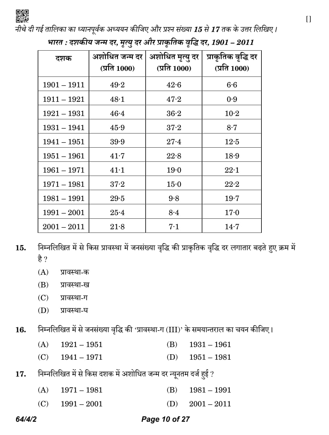
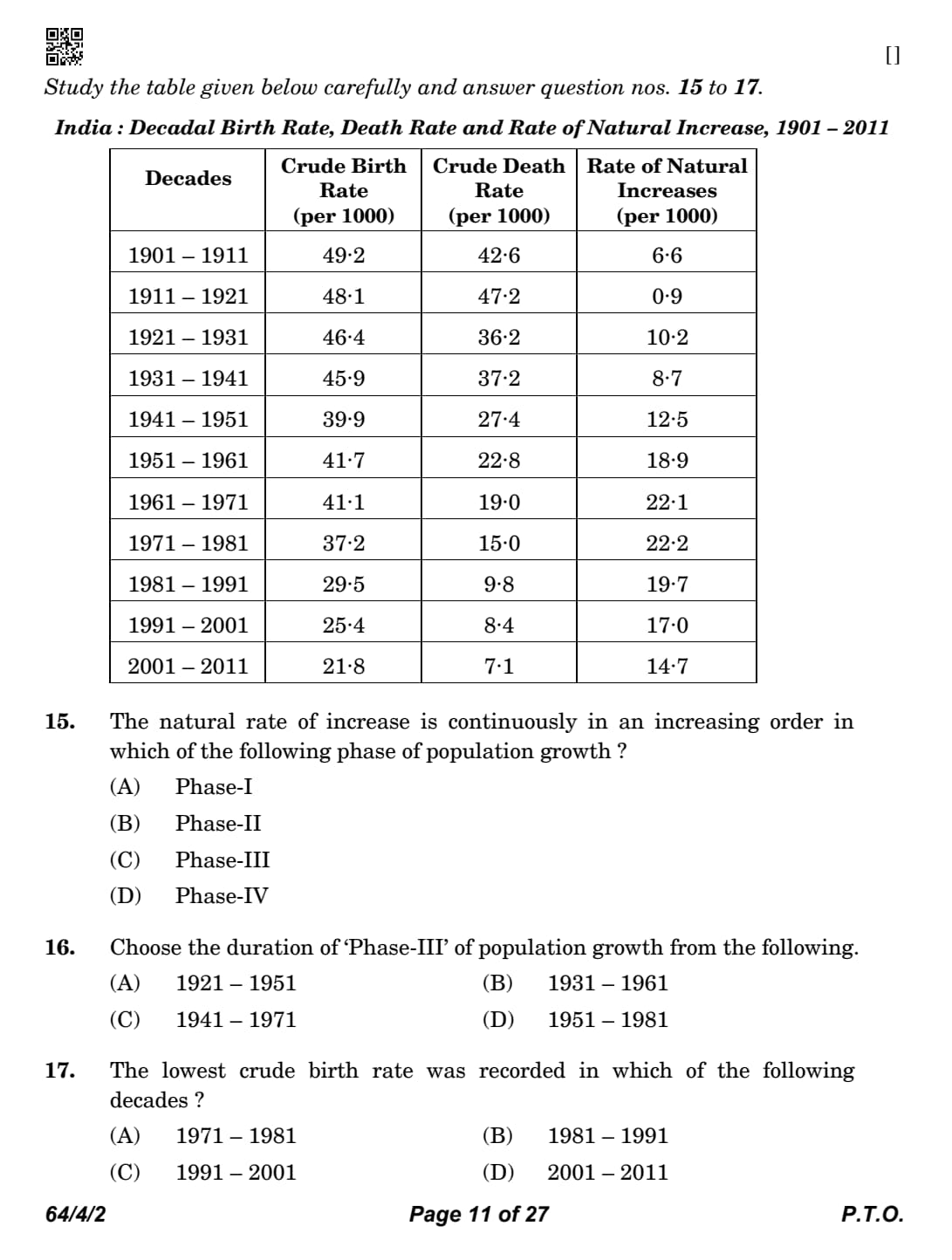
Study the table given below carefully and answer question nos. 15 to 17.

The natural rate of increase is continuously in an increasing order in which of the following phase of population growth ?
Detailed Solution
Concept:
India's population growth is divided into four distinct phases based on growth rates.
Phase I (\( 1901-1921 \)): Stagnant growth.
Phase II (\( 1921-1951 \)): Steady growth.
Phase III (\( 1951-1981 \)): Population explosion.
Phase IV (\( 1981- Present \)): High growth with a declining trend.
Step 1: Examine the data table for natural increase rates
The 'Rate of Natural Increase' column in the provided table shows:
\( 1941-1951 \): \( 12.5 \)
\( 1951-1961 \): \( 18.9 \)
\( 1961-1971 \): \( 22.1 \)
\( 1971-1981 \): \( 22.2 \)
Step 2: Identify the period of continuous increase
From \( 1951 \) to \( 1981 \), the natural increase rate rises continuously from \( 12.5 \) (pre-phase) to \( 22.2 \).
This period is known as the phase of "Population Explosion" due to a rapid fall in death rates while birth rates remained high.
Step 3: Match with the designated phase
The period from \( 1951 \) to \( 1981 \) corresponds to Phase-III.
After \( 1981 \), the rates start decreasing (\( 19.7 \rightarrow 17.0 \rightarrow 14.7 \)). Quick Tip: Phase III (\( 1951-1981 \)) = Population Explosion.
During this time, medical advances drastically reduced the death rate while the birth rate stayed high.
Choose the duration of ‘Phase-III’ of population growth from the following.
Detailed Solution
Concept:
India's population growth history is divided into four distinct stages based on birth and death rate trends.
These phases help in understanding the demographic transition of the country over the last century.
Step 1: Identify the historical classification of phases
Phase I (1901–1921) is the period of stagnant growth with high birth and death rates.
Phase II (1921–1951) is the period of steady growth where the death rate started to decline.
Phase III (1951–1981) is the period of population explosion due to a rapid fall in the death rate while the birth rate remained high.
Phase IV (Post-1981) is the period of high growth with a definite declining trend.
Step 2: Match with the question
The question specifically asks for Phase-III, which corresponds to the decades between 1951 and 1981.
This period saw the natural rate of increase peak at over 2.2% annually. Quick Tip: Phase-III (1951-81) = "Population Explosion".
This was caused by improved medical facilities and food security reducing mortality.
The lowest crude birth rate was recorded in which of the following decades ?
Detailed Solution
Concept:
The Crude Birth Rate (CBR) is the number of live births per thousand of the population per year.
Analyzing statistical tables requires identifying the correct column and finding the minimum value.
Step 1: Extract birth rate data from the provided table
1971 – 1981: \( 37.2 \)
1981 – 1991: \( 29.5 \)
1991 – 2001: \( 25.4 \)
2001 – 2011: \( 21.8 \)
Step 2: Identify the lowest value
By comparing the values in the "Crude Birth Rate" column, we can see a consistent downward trend from the early 1900s to 2011.
The value \( 21.8 \) recorded in the decade 2001–2011 is the lowest among all the decades listed in the source table. Quick Tip: CBR in India has been declining due to rising age of marriage, education, and family planning awareness.
Study the given map carefully and answer the questions that follow :

The shipping canal shown on the map connects which two seas ?
Detailed Solution
Concept:
The map displays the Suez Canal, a vital artificial sea-level waterway in Egypt.
It provides the shortest maritime route between Europe and the lands lying around the Indian and western Pacific oceans.
Step 1: Identify the geographical location on the map
The map shows a canal running through the Isthmus of Suez in Egypt.
The northern end opens into a large body of water which is the Mediterranean Sea.
Step 2: Identify the southern connection
The southern end of the canal enters the Gulf of Suez, which is a branch of the Red Sea.
Therefore, the canal connects the Mediterranean Sea and the Red Sea. Quick Tip: The Suez Canal (opened 1869) connects the North Atlantic and northern Indian oceans via the Mediterranean and Red Seas.
Name the northernmost and southernmost ports of this shipping canal.
Detailed Solution
Concept:
Ship canals often have major port cities at their entry and exit points to manage traffic and logistics.
Step 1: Identify the northern port
The northern terminus of the Suez Canal, located on the Mediterranean coast, is Port Said.
Step 2: Identify the southern port
The southern terminus of the canal, located on the Red Sea coast (specifically the Gulf of Suez), is Port Suez (or simply Suez).
In some contexts, Port Tewfik is cited as the specific harbor at the southern end. Quick Tip: North: Port Said.
South: Port Suez.
Mid-point: Ismailia.
Name the bay marked ‘A’ on the map.
Detailed Solution
Concept:
Maps often use letters to identify specific water bodies or landforms.
The area marked 'A' is situated to the east of the canal's exit into the northern sea.
Step 1: Locate the marker 'A'
Marker 'A' is pointing to the large water body at the top of the map, adjacent to the Sinai Peninsula.
This body of water is the Mediterranean Sea.
Step 2: Determine the specific coastal feature
While it is part of the Mediterranean Sea, the specific coastal indentation there is often referred to as the Bay of Pelusium (or Gulf of Tineh).
However, in standard geography curriculum maps for this canal, 'A' usually labels the Mediterranean Sea. Quick Tip: The Mediterranean Sea lies to the North of Africa and connects to the Atlantic through the Strait of Gibraltar.
Note : The following question is for the Visually Impaired Candidates only in lieu of Question No. 18.
Explain the economic significance of the Panama Canal.
Detailed Solution
Concept:
The Panama Canal is one of the most important artificial waterways in the world.
It connects the Atlantic Ocean (through the Caribbean Sea) with the Pacific Ocean.
The canal cuts across the Isthmus of Panama in Central America, eliminating the need for ships to travel around Cape Horn at the southern tip of South America.
It is regarded as one of the greatest engineering achievements because it has revolutionised international maritime transport and global trade.
The canal serves as a vital trade route for ships transporting raw materials, manufactured goods, petroleum products and agricultural commodities between the eastern and western parts of the world.
Step 1: Understand the importance of the Panama Canal.
Before the construction of the Panama Canal, ships travelling between the Atlantic Ocean and the Pacific Ocean had to undertake a very long and dangerous journey around Cape Horn in South America.
The construction of the canal provided a much shorter, safer and more economical sea route, greatly reducing travel time and transportation costs.
Thus, the Panama Canal became one of the busiest and most strategically important waterways in the world.
Step 2: Explain the first economic significance.
1. Reduces distance, travel time and transportation cost
The Panama Canal provides a direct link between the Atlantic and Pacific Oceans.
Ships no longer need to sail around the southern tip of South America, which saves thousands of kilometres of travel.
The shorter route reduces fuel consumption, operating expenses, travel time and freight charges, making international trade faster and more economical.
Step 3: Explain the second economic significance.
2. Promotes international trade and global commerce
The canal acts as a major international trade corridor connecting North America, South America, Europe, Asia and Oceania.
It facilitates the movement of a wide variety of goods such as machinery, petroleum, coal, iron ore, food grains, automobiles, chemicals and manufactured products.
By enabling quicker transportation of goods, the canal increases the efficiency of global trade and strengthens economic relations among different countries.
Step 4: Explain the third economic significance.
3. Encourages economic growth and port development
The Panama Canal has contributed significantly to the economic development of Panama by generating substantial revenue through canal tolls.
It has encouraged the growth of ports, shipping services, logistics, warehousing and related industries.
Many ports located along the canal route have developed into important commercial centres, creating employment opportunities and promoting regional economic development.
Step 5: Write the final answer.
Answer:
The economic significance of the Panama Canal is as follows:
It provides a shorter sea route between the Atlantic Ocean and the Pacific Ocean, thereby reducing travel distance, time and transportation costs.
It promotes international trade by facilitating the movement of goods between North America, South America, Europe, Asia and other parts of the world.
It contributes to economic growth by generating revenue, encouraging port development, expanding shipping activities and creating employment opportunities. Quick Tip: • Connects the Atlantic Ocean and the Pacific Ocean.
• Eliminates the long journey around Cape Horn.
• Saves time, fuel and transportation costs.
• Promotes international trade and global shipping.
• Generates revenue for Panama and supports port-based economic development.
Read the given passage carefully and answer the questions that follow :
Case for Free Trade
The act of opening up economies for trading is known as free trade or
trade liberalisation. This is done by bringing down trade barriers like
tariffs. Trade liberalisation allows goods and services from everywhere to
compete with domestic products and services.
Globalisation along with free trade can adversely affect the economies
of developing countries by not giving equal playing field by imposing
conditions which are unfavourable. With the development of transport
and communication systems, goods and services can travel faster and
farther than ever before. But free trade should not only let rich countries
enter the markets, but allow the developed countries to keep their own
markets protected from foreign products.
Countries also need to be cautious about dumped goods; as along with
free trade, dumped goods of cheaper prices can harm the domestic
producers.
Define the term ‘globalisation’.
Detailed Solution
Concept:
Globalisation is the process of rapid integration or interconnection between countries.
It involves the free flow of goods, services, capital, and labor across international borders.
Step 1: Define the core meaning based on the context
Globalisation is the increasing economic, social, and cultural integration of the world's nations.
It is driven by advancements in technology, trade liberalization, and the expansion of multinational corporations.
Step 2: Identify the practical outcome
It leads to the world becoming a "global village" where distances are reduced by communication and transport systems, and economies become interdependent. Quick Tip: Globalisation = Interconnectivity + Interdependence.
Key drivers: Technology (ICT) and Liberalisation (Policy).
Explain the importance of transport system in ‘world trade’.
Detailed Solution
Concept:
Trade requires the physical movement of goods from the producer to the consumer across varying distances.
Step 1: Analyze the role of transport in trade facilitation
Efficient transport systems act as the backbone of international trade by allowing goods and services to travel faster and farther than ever before.
They reduce the "friction of distance," making it cost-effective to source raw materials from one country and sell finished products in another.
Step 2: Link transport to market expansion
Advancements in shipping, aviation, and containerization have expanded the reach of markets, allowing even landlocked or remote areas to participate in global value chains.
Without modern transport, the volume and variety of goods traded globally today would be impossible to maintain. Quick Tip: Transport is the "circulatory system" of world trade.
Lower transport costs = Higher trade volumes.
Why can ‘free trade’ adversely affect domestic producers ?
Detailed Solution
Concept:
Free trade removes barriers like tariffs and quotas, leading to intense international competition.
Step 1: Identify the competition challenge
Free trade allows foreign goods to enter domestic markets without significant restrictions.
Domestic producers, especially in developing countries, may not have the technology or scale to compete with cheaper, mass-produced imports from developed nations.
Step 2: Analyze the problem of "dumping"
Countries may "dump" goods (sell them at prices lower than the cost of production) in foreign markets to capture market share.
This practice harms domestic producers, potentially leading to business closures and job losses in local industries that cannot match those artificially low prices. Quick Tip: Free trade benefits consumers (lower prices) but can hurt local producers who lack a "level playing field."
“Technology indicates the level of cultural development of a society.” Justify the statement with example.
Detailed Solution
Concept:
Human geography explores how humans interact with their environment.
Technology is the application of scientific knowledge for practical purposes.
Step 1: Explain the relationship between technology and society
Technology reflects how much a society understands the laws of nature.
A society with primitive technology is often highly dependent on nature and follows its dictates (Environmental Determinism).
Step 2: Justify with examples
In the early stages of human history, people were dictated by the natural environment because their technological level was low.
As cultural development progressed, humans invented tools and machines that allowed them to modify the environment (Possibilism).
For example, the invention of genetic engineering or sophisticated irrigation systems allows societies to grow crops in harsh climates, which was impossible for culturally "primitive" societies.
Another example is the use of air conditioning, which allows large-scale urban development in desert regions, showcasing a high level of cultural and technological control over the environment. Quick Tip: Technology = Human liberation from nature's constraints.
Advanced Technology = Higher Cultural Development.
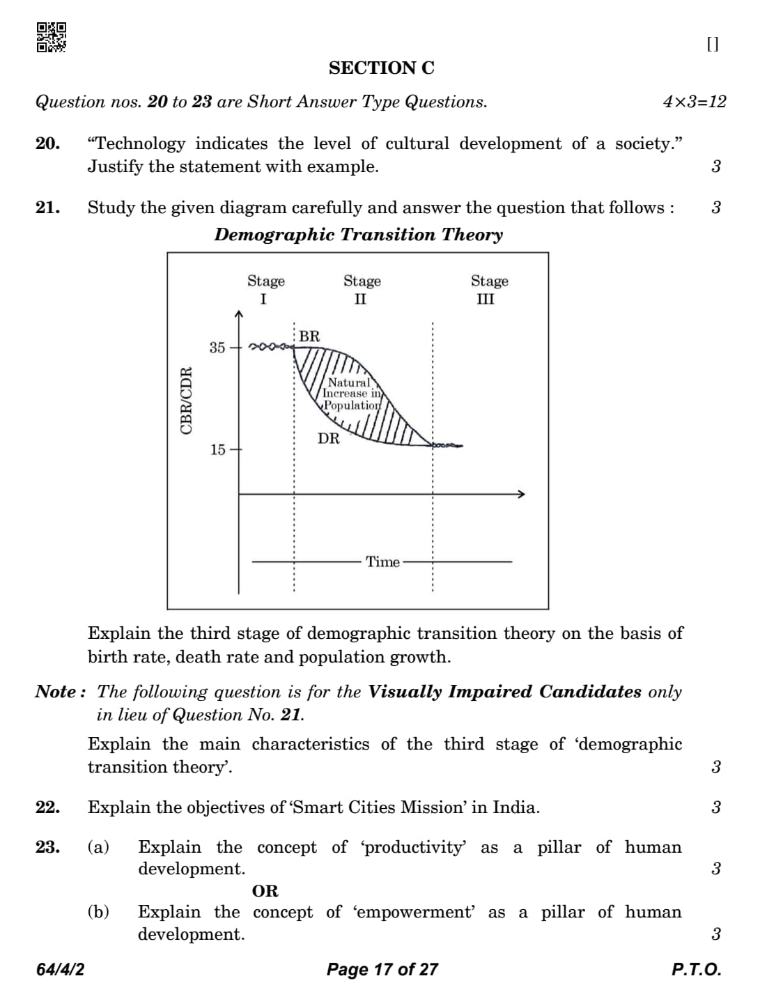
Study the given diagram carefully and answer the question that follows :

Explain the third stage of demographic transition theory on the basis of birth rate, death rate and population growth.
Detailed Solution
Concept:
Demographic Transition Theory describes the transition from high birth and death rates to low birth and death rates as a country develops.
Stage III (The Post-Transitional Stage) represents a mature, industrialized, and urbanized society.
Step 1: Analyze the trends in birth and death rates
In the third stage, both the birth rate and the death rate decline considerably.
The rates eventually reach a low level and become almost equal.
Step 2: Explain the resulting population growth
Because the birth and death rates are both low and similar, the population growth becomes stable.
The population may grow very slowly or even become stationary.
Step 3: Describe the underlying socio-economic causes
The society becomes urbanized and literate.
Families grow smaller as parents deliberately control family size.
High levels of technical knowledge allow for better healthcare and living standards. Quick Tip: Stage I: High BR, High DR (Stagnant).
Stage II: High BR, Low DR (Explosion).
Stage III: Low BR, Low DR (Stable).
Note : The following question is for the Visually Impaired Candidates only in lieu of Question No. 21.
Explain the main characteristics of the third stage of ‘demographic
transition theory’.
Detailed Solution
Concept:
The Demographic Transition Theory explains how the population of a country changes with economic development and modernization.
It describes the transition of a country from high birth and death rates to low birth and death rates through different stages.
The Third Stage is known as the Late Expanding Stage.
In this stage, the birth rate begins to decline rapidly, while the death rate remains low, resulting in a slower rate of population growth compared to the previous stage.
Step 1: Birth Rate
During the third stage, the birth rate declines significantly.
This decline occurs due to several social and economic changes such as:
Increased literacy and education.
Improvement in the status of women.
Urbanisation and industrialisation.
Greater awareness of family planning methods.
Preference for smaller families.
Increased cost of raising and educating children.
As a result, families voluntarily choose to have fewer children.
Step 2: Death Rate
The death rate remains very low during this stage.
The low death rate is maintained because of continuous improvements in:
Medical facilities.
Public health services.
Nutrition and food supply.
Safe drinking water.
Sanitation and hygiene.
Better living standards.
These developments increase life expectancy and reduce mortality.
Step 3: Population Growth
Since the birth rate starts declining while the death rate remains low, the population continues to grow but at a much slower rate than in Stage II.
The gap between birth rate and death rate gradually becomes smaller, causing the natural increase in population to decline.
Step 4: Socio-economic Characteristics
Countries in the third stage generally experience rapid economic development and social transformation.
Important characteristics include:
High level of urbanisation.
Expansion of industries and service sector.
Higher literacy rate.
Better employment opportunities.
Improved standard of living.
Increased participation of women in education and workforce.
Widespread use of contraceptives and family welfare programmes.
These factors collectively contribute to the decline in fertility.
Step 5: Examples
Many developing countries such as India, Brazil, Mexico and South Africa are considered to be in the third stage of demographic transition.
These countries have experienced a considerable decline in birth rates while maintaining low death rates due to improvements in healthcare and economic development.
Answer:
The main characteristics of the Third Stage (Late Expanding Stage) of the Demographic Transition Theory are:
Birth rate declines rapidly.
Death rate remains low.
Population continues to increase but at a slower rate.
Natural growth rate decreases because the gap between birth rate and death rate becomes smaller.
Urbanisation, industrialisation, education, improved healthcare, higher standard of living and family planning contribute to declining fertility. Quick Tip: • Third Stage = Late Expanding Stage.
• Birth Rate \(\downarrow\) Declining rapidly.
• Death Rate \(\rightarrow\) Remains low.
• Population Growth \(\uparrow\) Continues, but at a slower rate.
• Major reasons: Urbanisation, education, women's empowerment, improved healthcare and family planning.
• India is generally considered to be in the Third Stage of the Demographic Transition Theory.
Explain the objectives of ‘Smart Cities Mission’ in India.
Detailed Solution
Concept:
The Smart Cities Mission is an urban renewal program launched by the Government of India.
Its goal is to promote cities that provide core infrastructure and give a decent quality of life to its citizens.
Step 1: Identify the core infrastructure objectives
The mission aims to provide basic services like 24/7 water supply and assured electricity.
It focuses on efficient urban mobility and public transport.
It emphasizes sanitation, including solid waste management.
Step 2: Focus on sustainability and safety
A major objective is to create a sustainable and clean environment.
The mission seeks to improve safety and security of citizens, particularly through the use of technology (surveillance).
Step 3: Apply 'Smart' technology solutions
The mission promotes the use of "Smart" solutions for infrastructure and services.
This includes IT connectivity, e-governance, and citizen participation in city management.
The objective is to make city life more efficient and less resource-heavy. Quick Tip: Smart Cities focus on:
1. Infrastructure (Water/Power).
2. Efficiency (IT/Apps).
3. Quality of Life (Green/Safe).
Explain the concept of ‘productivity’ as a pillar of human development.
Detailed Solution
Concept:
Human development is supported by four essential pillars: Equity, Sustainability, Productivity, and Empowerment.
These pillars represent the fundamental requirements for expanding the range of choices and capabilities available to people.
Step 1: Defining productivity in the context of human development
In the human development paradigm, productivity specifically refers to human labor productivity or productivity in terms of human work.
It emphasizes that people are the real wealth of nations and their creative efforts drive progress.
Step 2: Building human capabilities through social investment
To increase human productivity, a society must continuously invest in building the capabilities of its people.
This is achieved through providing better healthcare facilities, quality education, and advanced skill development programs.
Step 3: Linking individual well-being to national productivity
A healthy and educated individual is more capable of performing work efficiently and creatively compared to an individual lacking these resources.
Therefore, improving the quality of human life directly leads to an increase in the overall productivity and economic strength of a nation. Quick Tip: Productivity = Investment in human capital.
Better Health + Education = Higher Human Productivity and better economic outcomes.
Explain the concept of ‘empowerment’ as a pillar of human development.
Detailed Solution
Concept:
Empowerment is one of the four key pillars that sustain the idea of human development.
It focuses on the distribution of power and the ability of individuals and groups to influence the decisions that affect their lives.
Step 1: Defining the core of empowerment as the power to choose
Empowerment fundamentally means having the power to make choices.
In many societies, various groups are restricted from making choices due to economic, social, or political barriers.
Empowerment aims to remove these constraints to ensure everyone has agency.
Step 2: The role of freedom and capability in empowerment
The ability to choose comes from an increase in human freedom and enhanced capabilities.
When people are free from hunger, fear, and ignorance, they are more capable of exercising their rights and participating in the developmental process.
Step 3: Policy requirements for equitable empowerment
Empowerment requires good governance and people-oriented policies that are inclusive and transparent.
Special focus must be placed on empowering socially and economically backward groups, as well as women, to ensure that the benefits of human development reach every segment of society. Quick Tip: Empowerment = Freedom + Capability to choose.
Inclusive policies and good governance are the primary tools for achieving empowerment in a society.
“Human-made processes are more responsible than natural processes for increase in wasteland.” Support the statement and suggest measures to reduce this problem.
Detailed Solution
Concept:
Wasteland refers to degraded land that is currently underutilized and can potentially be brought under cultivation or forest cover.
While natural factors like wind and water erosion create wastelands, human activities accelerate this process significantly.
Step 1: Support the statement with examples of human-made processes
Overgrazing by livestock removes vegetative cover, leading to soil erosion.
Deforestation for timber or agriculture leaves the soil vulnerable to the elements.
Unscientific irrigation leads to salinization and waterlogging, turning fertile land into wasteland.
Mining activities leave large areas abandoned and degraded without proper restoration.
Step 2: Suggest measures to reduce wasteland increase
Afforestation and social forestry should be promoted to restore land cover.
Grazing should be regulated and rotational grazing or stall-feeding should be encouraged.
Implementation of watershed management projects can check erosion and harvest water.
Mining laws must mandate the reclamation and leveling of mined-over areas.
Promotion of drip irrigation and sustainable agricultural practices can prevent salinization. Quick Tip: Natural wasteland: Gullied/Ravine land.
Human-made wasteland: Saline land/Abandoned mines.
Solution: Watershed management + Controlled grazing.
“The developed economies are retreating from mining and processing.” Support the statement with examples.
Detailed Solution
Concept:
Mining is a primary activity that involves the extraction of minerals and other geological materials from the earth.
The location of mining and processing industries is determined by both physical factors (quality and quantity of ore) and economic factors (demand, technology, labor, and transport).
Step 1: Analyzing the role of labor costs
Mining is a labor-intensive activity.
In developed economies like those in Western Europe and North America, labor costs are extremely high.
This makes the domestic extraction of minerals less competitive compared to importing them.
Step 2: Impact of environmental regulations
Developed nations have implemented very strict environmental protection laws.
Mining often leads to deforestation, water pollution, and land degradation.
The cost of adhering to these strict environmental standards and performing land reclamation significantly increases the overall operational cost.
Step 3: Providing global examples of the retreat
Many European countries have significantly reduced or completely stopped coal mining.
For example, coal mining in the United Kingdom and Germany, which once fueled the Industrial Revolution, has seen a massive decline.
Instead, mining operations have shifted to developing countries in Africa, Asia, and South America where labor is cheap and environmental regulations are often less stringent. Quick Tip: 1. High labor costs drive mining out of developed nations.
2. Developing nations now dominate mining due to lower costs and fewer regulations.
3. Developed economies now focus more on service and technology sectors.
“Intensive subsistence agriculture is largely practised in densely populated regions of Monsoon Asia.” Support the statement with examples.
Detailed Solution
Concept:
Subsistence agriculture is a type of farming where the primary goal is to feed the farmer's family.
Intensive subsistence agriculture is characterized by high output per unit of land but low output per worker, due to the extremely high population pressure on limited land.
Step 1: Impact of high population density on land holdings
In regions of Monsoon Asia, the population density is very high.
This results in the fragmentation of land holdings into very small, uneconomical plots.
Every available inch of land is used for cultivation to meet the food requirements of the large population.
Step 2: Labor and input intensity
The farming process is highly labor-intensive, relying mostly on human and animal power.
There is very little use of expensive machinery.
Farmers use large amounts of organic manure and traditional fertilizers to maintain soil fertility for multiple crops a year.
Step 3: Regional variations and examples
Intensive subsistence agriculture is divided into two types: one dominated by wet paddy and the other by other crops.
Wet paddy cultivation is dominant in areas with high rainfall, such as the Ganga-Brahmaputra plains in India, the Yangtze valley in China, and the Mekong delta in Vietnam.
In drier areas, such as North China and Western India (Punjab/Rajasthan), crops like wheat, millets, and sorghum are grown using similar intensive methods. Quick Tip: 1. Small land holdings + high labor = Intensive Subsistence.
2. Wet Paddy is the main crop in high-rainfall Monsoon regions.
3. Yield per unit area is high, but yield per farmer is low.
Analyse the changing pattern of export composition in India between 2009 to 2017.
Detailed Solution
Concept:
Export composition refers to the various types of commodities that a country sells to the international market.
Changes in this composition reflect the structural transformation of the domestic economy.
Over time, India has shifted from exporting primary products to manufactured and value-added goods.
Step 1: Shift in the share of agricultural and allied products
The share of traditional agricultural products like tea, coffee, and spices has shown a declining trend in terms of total percentage.
However, fresh fruits, vegetables, and processed food items have shown some growth.
Step 2: Rise of manufactured and engineering goods
There has been a significant increase in the share of manufactured goods.
Engineering goods, such as machinery, transport equipment, and electronics, have become dominant exports.
This indicates the growing technological capability of the Indian industrial sector.
Step 3: Expansion of chemical and related products
The export of chemicals and chemical products, including pharmaceuticals, has grown rapidly.
India has emerged as a major global supplier of generic medicines.
Step 4: Dominance of petroleum products and jewelry
Petroleum products emerged as a major export item due to the expansion of domestic refining capacity.
Gems and jewelry continue to hold a large share, although their percentage contribution fluctuated during this period. Quick Tip: 1. India is moving from "Raw Material Exporter" to "Manufactured Goods Exporter."
2. Engineering goods and Petroleum products are the current leaders in the export basket.
Analyse the changing pattern of import composition in India between 2009 to 2017.
Detailed Solution
Concept:
Import composition indicates the nature of goods a country buys from abroad to meet its domestic demand and industrial requirements.
India's import basket is heavily influenced by its energy needs and industrialization goals.
Step 1: Persistence of Petroleum, Oil, and Lubricants (POL)
POL remains the single largest item in India's import bill.
Rapid urbanization and industrial growth have kept the demand for energy very high.
Price fluctuations in the international market significantly affect the total value of these imports.
Step 2: Increase in capital goods imports
There has been a consistent demand for capital goods like machinery, transport equipment, and high-tech electronics.
These imports are essential for the expansion of India's manufacturing and infrastructure sectors.
Step 3: Trends in gold and precious metals
Gold imports remained a significant part of the non-POL import bill.
Despite various government restrictions to control the current account deficit, the cultural and investment demand for gold persisted.
Step 4: Import of raw materials for export-oriented industries
India imports large quantities of pearls, precious stones, and semi-precious stones.
These are processed domestically and then re-exported as finished jewelry, adding significant value. Quick Tip: 1. POL (Petroleum) is always the biggest import item.
2. Rising capital goods imports indicate a focus on industrial self-reliance and "Make in India."
Define the term ‘outsourcing’. Explain the benefits of outsourcing for developing countries.
Detailed Solution
Concept:
Outsourcing is a business practice where a company hires a third party (outside agency) to perform tasks or handle operations.
These tasks were traditionally performed in-house by the company's own employees.
When outsourcing happens across international borders, it is called off-shoring.
Step 1: Defining outsourcing and its types
Outsourcing involves contracting out functions like IT services, customer support (BPO), or research (KPO).
It is driven by the desire to reduce costs and access specialized expertise.
Step 2: Benefit: Massive job creation
Developing countries with large, educated populations (like India and the Philippines) benefit from millions of new jobs.
These jobs are often in the high-growth service sector and provide better wages than traditional sectors.
Step 3: Benefit: Foreign exchange and economic growth
Outsourcing brings in significant foreign currency earnings.
This helps in improving the country's balance of payments and fuels overall GDP growth.
Step 4: Benefit: Skill development and knowledge transfer
Local employees get exposed to global business standards and advanced technologies.
This leads to a "brain gain" as local talent becomes globally competitive and skilled. Quick Tip: Outsourcing = Cost cutting for developed nations + Job creation for developing nations.
It has turned India into the "back-office of the world."
Define the term ‘digital divide’. Explain the difference of digital divide between developed and developing countries.
Detailed Solution
Concept:
The digital divide refers to the gap between demographics and regions that have access to modern information and communication technology (ICT) and those that do not.
It is not just about physical access, but also about the speed of connection and the ability to use the technology effectively.
Step 1: Definition of the digital divide
It is the inequality in terms of access to, use of, or knowledge of ICT.
This divide exists between countries and also within a country (e.g., rural vs. urban).
Step 2: ICT status in developed countries
Developed countries have near-universal access to high-speed internet.
They have well-developed infrastructure and affordable hardware.
Information is a key driver of their economies, and citizens are highly digitally literate.
Step 3: ICT status in developing countries
Developing countries often struggle with limited infrastructure and high costs of internet services.
Large parts of the population, especially in rural areas, remain disconnected.
This limits their access to e-education, e-health, and global market opportunities.
Step 4: The widening gap
While developed nations move towards 5G and AI, some developing nations are still struggling with basic connectivity.
This creates a cycle where the "information rich" get richer and the "information poor" fall further behind. Quick Tip: Digital Divide = ICT Have-nots vs. ICT Haves.
Closing this gap is essential for achieving equitable global human development.
Explain the benefits of the Indira Gandhi Canal in its command area.
Detailed Solution
Concept:
The Indira Gandhi Canal (formerly Rajasthan Canal) is one of the largest canal systems in India.
It was designed to bring Himalayan water to the arid regions of North-Western Rajasthan.
The project has fundamentally changed the geography and economy of the region.
Step 1: Ecological transformation through afforestation
The availability of canal water has led to large-scale afforestation and pasture development.
This has helped in stabilizing sand dunes and reducing the intensity of dust storms in the Thar Desert.
Step 2: Transformation of the agricultural landscape
Vast tracts of desert land have been brought under intensive cultivation.
Traditional drought-resistant crops like bajra and guar have been replaced by commercial crops.
Farmers now grow wheat, cotton, mustard, and groundnut, leading to a massive increase in agricultural production.
Step 3: Economic prosperity and food security
The region, which was once prone to frequent famines, has become a "granary" for Rajasthan.
Ganganagar and Hanumangarh districts have seen a significant rise in per capita income and living standards.
Step 4: Social benefits and drinking water supply
The canal provides a reliable source of drinking water to numerous villages and towns.
It has encouraged the permanent settlement of formerly nomadic populations, leading to social stability. Quick Tip: 1. Desert \(\rightarrow\) Green fields.
2. Subsistence crops \(\rightarrow\) Commercial crops (Wheat/Cotton).
3. Drinking water availability for millions.
Explain the benefits to the Bharmaur region through the implementation of the Integrated Tribal Development Project.
Detailed Solution
Concept:
The Bharmaur region in Himachal Pradesh is the homeland of the 'Gaddi' tribal community.
The Integrated Tribal Development Project (ITDP) was launched in the 1970s to improve the socio-economic conditions of this marginalized area.
Step 1: Development of essential infrastructure
The project focused on building roads, providing electricity, and ensuring clean drinking water.
Schools and primary health centers were established in remote areas.
This significantly improved the accessibility and basic living conditions of the Gaddi people.
Step 2: Revolution in education and literacy
The most significant impact has been on literacy rates.
Female literacy in Bharmaur increased from almost zero to over 40-50% in a few decades.
This has empowered the younger generation and reduced social inequalities.
Step 3: Economic diversification
Traditionally, the Gaddis were nomadic pastoralists.
The ITDP encouraged a shift toward commercial agriculture and horticulture.
Cultivation of apples and other cash crops has increased the household income and reduced dependence on transhumance.
Step 4: Improved demographic indicators
There has been a marked improvement in the sex ratio and a decline in child mortality rates.
The overall quality of life and social awareness have increased significantly due to targeted development interventions. Quick Tip: 1. Huge jump in female literacy.
2. Shift from nomadic pastoralism to cash crops (Apples).
3. Better health and road connectivity for the Gaddi tribe.
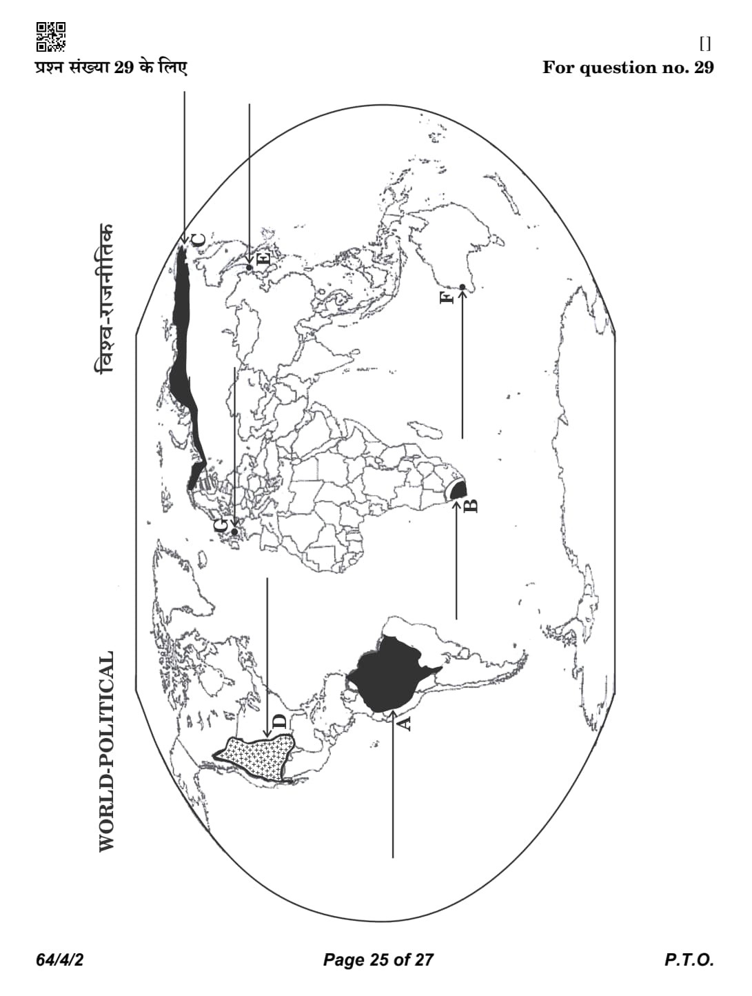
On the given political outline map of the World (on page 25), seven
geographical features have been marked as A, B, C, D, E, F and G.
Identify any five with the help of the following information and write
their correct names on the lines drawn near them.
A. A major area of subsistence gathering
B. A major area of extensive commercial grain farming
C. A major area of nomadic herding
D. A major area of commercial livestock rearing
E. A terminal station of trans-continental railway
F. A major sea port
G. A major international airport

Detailed Solution
Concept:
Map-based questions test the ability of students to identify important geographical features correctly.
The features may include natural regions, transport routes, ports, airports, agricultural regions, grasslands and important cities.
Careful observation of the location, surrounding countries and physical features helps in identifying the correct answer.
The following geographical features have been identified from the given world political map.

Step 1: Identify Feature A.
The shaded region in northern South America represents the world's largest equatorial rainforest region.
\[ \boxed{\textbf{A -- Amazon Basin}} \]
Step 2: Identify Feature B.
The marked location in South Africa represents the famous temperate grassland region.
\[ \boxed{\textbf{B -- Velds}} \]
Step 3: Identify Feature C.
The marked location in western Europe represents one of the world's leading global cities.
\[ \boxed{\textbf{C -- London}} \]
Step 4: Identify Feature D.
The shaded region in western North America represents an important agricultural region.
\[ \boxed{\textbf{D -- United States of America}} \]
Step 5: Identify Feature E.
The shaded belt across northern Eurasia represents the cold climatic natural vegetation region.
\[ \boxed{\textbf{E -- Tundra Region of Eurasia}} \]
Step 6: Identify Feature F.
The marked city on the south-western coast of Australia represents the terminal station of the Trans-Australian Railway.
\[ \boxed{\textbf{F -- Perth}} \] Quick Tip: • A \(\rightarrow\) Amazon Basin (Equatorial Forest Region)
• B \(\rightarrow\) Velds (Temperate Grasslands of South Africa)
• C \(\rightarrow\) London (Major Sea Port)
• D \(\rightarrow\) United States of America (Commercial Grain Farming Region)
• E \(\rightarrow\) Tundra Region of Eurasia (Subsistence Gathering Region)
• F \(\rightarrow\) Perth (Terminal Station of the Trans-Australian Railway)
• Always identify the continent first, then observe nearby oceans, countries and physical features before locating the correct answer.
Note :The following questions are for the Visually Impaired Candidates
only in lieu of Question No. 29.
Name a major area of subsistence gathering in South America.
Detailed Solution
Concept:
Gathering is one of the oldest economic activities, practiced in regions with harsh climates or remote environments.
It involves collecting wild plants and hunting animals for basic survival.
In the low latitude zones, the Amazon Basin is a primary region for this activity.
Step 1: Identify the geographical region
The Amazon Basin in South America is a vast tropical rainforest area.
Step 2: Relate to the economic activity
Due to the dense forest and traditional lifestyle of indigenous tribes, gathering of forest produce like nuts, berries, and medicinal plants remains a key subsistence activity in this region.
Step 3: Conclusion
The major area of subsistence gathering in South America is the Amazon Basin. Quick Tip: 1. Gathering is practiced in two zones: High latitude (Arctic/Canada) and Low latitude (Amazon/Congo).
2. It is a primitive activity with very low capital investment and no surplus for trade.
Name a major area of extensive commercial grain farming in Africa.
Detailed Solution
Concept:
Extensive commercial grain farming is practiced in the interior parts of semi-arid lands of the mid-latitudes.
It is characterized by large farm sizes, high mechanization, and the dominance of a single crop (usually wheat).
These regions are known by different names in different continents.
Step 1: Recall regional names for temperate grasslands
Eurasia: Steppes; North America: Prairies; South America: Pampas; South Africa: Velds; Australia: Downs.
Step 2: Identify the African region
The temperate grasslands located in South Africa are known as the Velds.
Step 3: Conclusion
The major area of extensive commercial grain farming in Africa is the Velds. Quick Tip: 1. Commercial Grain Farming = Low yield per acre but high yield per person.
2. Location is always mid-latitude temperate grasslands.
Name a major area of nomadic herding in Asia.
Detailed Solution
Concept:
Nomadic herding (pastoral nomadism) is a primitive subsistence activity where herders move from place to place with their livestock in search of pastures and water.
It is practiced in arid and semi-arid regions.
Step 1: Identify nomadic herding belts in Asia
Major areas include the Arabian Peninsula, Central Asia, and the Tundra region of Northern Eurasia (North Russia/Siberia).
Step 2: Select a prominent example
The Tundra region of Northern Eurasia is a major belt where tribes like the Samoyeds and Chukchi herd reindeer.
Alternatively, Central Asia (Mongolia and Western China) is another massive belt for herding yaks, sheep, and goats.
Step 3: Conclusion
A major area of nomadic herding in Asia is the Tundra region of Northern Eurasia (or Central Asia). Quick Tip: 1. Nomads move seasonally: "Transhumance" (mountains to plains in winter and vice versa).
2. Technology level is very low; livestock is the primary wealth.
Name a major area of commercial livestock rearing in North America.
Detailed Solution
Concept:
Commercial livestock rearing is a more organized and capital-intensive activity compared to nomadic herding.
It is practiced on permanent ranches in temperate grasslands.
Step 1: Identify the North American temperate grassland
The vast plains in the central part of North America (USA and Canada) are called the Prairies.
Step 2: Describe the activity on the Prairies
Vast ranches are used to rear cattle for meat and dairy products using scientific methods and advanced processing.
Step 3: Conclusion
The major area of commercial livestock rearing in North America is the Prairies. Quick Tip: 1. Unlike nomadic herding, livestock rearing is a market-oriented activity.
2. Focus is on scientific breeding, health care, and processed meat exports.
Name the easternmost terminal station of Trans-Siberian railway.
Detailed Solution
Concept:
The Trans-Siberian Railway is the longest trans-continental railway line in the world.
it connects European Russia with the Russian Far East.
Step 1: Identify the terminals of the line
The railway line runs from St. Petersburg in the west to the Pacific coast in the east.
Step 2: Name the eastern terminal
The easternmost station, located on the Sea of Japan, is Vladivostok.
Step 3: Conclusion
The easternmost terminal station of the Trans-Siberian railway is Vladivostok. Quick Tip: 1. Length: approx. 9,332 km.
2. It was vital for the opening up of the Siberian interior to trade and military transport.
Name the place in Western Australia where a major sea port is located.
Detailed Solution
Concept:
Major seaports are the gateways of international trade.
Australia has several major ports located in its state capitals.
Step 1: Identify the capital city of Western Australia
Perth is the capital and largest city of the state of Western Australia.
Step 2: Identify its port
The major port serving the city of Perth is Fremantle, located at the mouth of the Swan River. Often, "Perth" is used to identify this location on global thematic maps.
Step 3: Conclusion
The place in Western Australia where a major sea port is located is Perth (Fremantle). Quick Tip: 1. Perth is the most isolated continental capital in the world.
2. It is a major hub for mineral exports from Western Australian mines.
Name the place of the United Kingdom where a major international airport is located.
Detailed Solution
Concept:
International airports are nodes of the quaternary sector and global transport networks.
Major hubs are usually located near capital cities or financial centers.
Step 1: Identify the primary aviation hub of the UK
London is the main gateway for international travel to and from the United Kingdom.
Step 2: Identify the specific major airport
Heathrow Airport in London is one of the busiest and most well-known international airports in the world.
Step 3: Conclusion
The place in the United Kingdom where a major international airport is located is London (Heathrow). Quick Tip: 1. London acts as a primary "hub and spoke" center for transatlantic flights.
2. It connects Europe with North America and Asia.
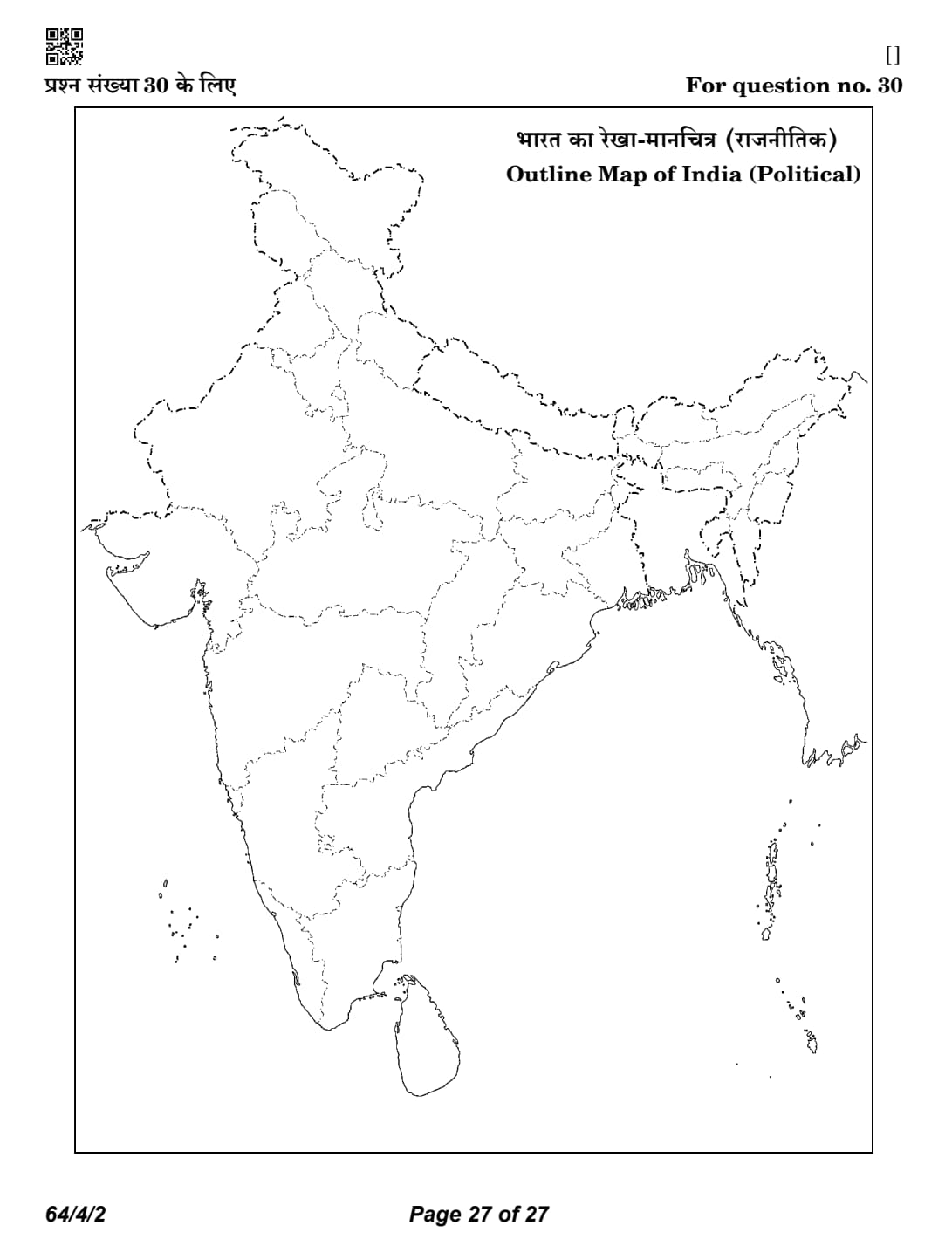
On the given political outline map of India (on page 27), locate and label any five of the following seven geographical features with the
appropriate symbols :
(1.) The state leading in tea production
(2.) The iron-ore mines in coastal Maharashtra
(3.) An oil refinery located in Bihar
(4.) The coal mines located in West Bengal
(5.) A major sea port located in Andhra Pradesh
(6.) An international airport located in Telangana
(7.) The state having the lowest population density (2011)

Detailed Solution
Concept:
Map-based questions test the ability of students to identify important geographical features correctly on the political outline map of India.
These features may include leading producing states, mineral belts, oil refineries, sea ports, airports and demographic characteristics.
Such questions require a sound understanding of India's economic and human geography.
Correct identification of the state or location and accurate marking on the map are essential for scoring full marks.
The following geographical features have been correctly identified from the given map.

Step 1: Identify Feature (30.1).
The state marked in the north-eastern part of India is the leading producer of tea.
\[ \boxed{\textbf{(30.1) -- Assam}} \]
Step 2: Identify Feature (30.2).
The marked location on the western coast of Maharashtra represents an important iron-ore mining area.
\[ \boxed{\textbf{(30.2) -- Ratnagiri}} \]
Step 3: Identify Feature (30.3).
The marked location in Bihar represents one of India's important oil refineries.
\[ \boxed{\textbf{(30.3) -- Barauni}} \]
Step 4: Identify Feature (30.4).
The marked location in West Bengal represents one of the oldest coal mining areas of India.
\[ \boxed{\textbf{(30.4) -- Raniganj}} \]
Step 5: Identify Feature (30.5).
The marked location on the eastern coast of Andhra Pradesh represents a major sea port.
\[ \boxed{\textbf{(30.5) -- Visakhapatnam}} \]
Step 6: Identify Feature (30.6).
The marked location in Telangana represents an important international airport.
\[ \boxed{\textbf{(30.6) -- Hyderabad}} \]
Step 7: Identify Feature (30.7).
The shaded state in the north-eastern Himalayan region has the lowest population density according to Census 2011.
\[ \boxed{\textbf{(30.7) -- Arunachal Pradesh}} \] Quick Tip: • 30.1 \(\rightarrow\) Assam (Leading Tea Producing State)
• 30.2 \(\rightarrow\) Ratnagiri (Iron-ore Mines, Maharashtra)
• 30.3 \(\rightarrow\) Barauni (Oil Refinery, Bihar)
• 30.4 \(\rightarrow\) Raniganj (Coal Mining Area, West Bengal)
• 30.5 \(\rightarrow\) Visakhapatnam (Major Sea Port, Andhra Pradesh)
• 30.6 \(\rightarrow\) Hyderabad (International Airport, Telangana)
• 30.7 \(\rightarrow\) Arunachal Pradesh (Lowest Population Density according to Census 2011)
• In CBSE map work, first identify the state, then locate the city, mine, port or refinery accurately using nearby state boundaries and coastlines.
Note : The following questions are for the Visually Impaired Candidates only in lieu of Question No. 30.
Name the state leading in tea production in India.
Detailed Solution
Concept:
Tea is a major plantation crop in India, requiring high rainfall and well-drained loamy soils.
It is a labor-intensive industry located primarily in the hilly tracts of North-East and South India.
Step 1: Identify the primary tea-growing region
The Brahmaputra and Surma valleys in North-East India are the heart of the country's tea industry.
Step 2: Identify the leading state
Assam accounts for more than half of India's total tea production, making it the undisputed leader in this sector.
Step 3: Conclusion
The state leading in tea production is Assam. Quick Tip: 1. Assam is the largest producer in India.
2. West Bengal (Darjeeling/Jalpaiguri) is the second largest producer.
Name the iron-ore mines located in coastal Maharashtra.
Detailed Solution
Concept:
Iron ore is a basic mineral and the backbone of industrial development.
In Maharashtra, iron ore deposits are found in the Konkan (coastal) region and the eastern districts.
Step 1: Identify the coastal mineral belt of Maharashtra
The Konkan coast, particularly the districts of Ratnagiri and Sindhudurg, contains significant deposits of iron ore.
Step 2: Identify the specific mining location
Ratnagiri is the most prominent coastal mining area in Maharashtra, where ore is often exported through local ports like Redi.
Step 3: Conclusion
The iron-ore mines in coastal Maharashtra are located in Ratnagiri. Quick Tip: Iron ore in Maharashtra is found in two pockets:
1. Coastal (Ratnagiri/Sindhudurg).
2. Vidarbha (Chandrapur/Gadchiroli).
Name the oil refinery located in Bihar.
Detailed Solution
Concept:
Oil refineries are industrial plants where crude oil is processed into useful products like gasoline, diesel, and kerosene.
Refineries in India are either market-based or field-based.
Step 1: Identify the oil processing infrastructure in Bihar
Bihar has one major public sector oil refinery operated by Indian Oil Corporation Limited (IOCL).
Step 2: Identify the location
The refinery is located at Barauni in the Begusarai district. It was built with assistance from the former Soviet Union.
Step 3: Conclusion
The oil refinery located in Bihar is at Barauni. Quick Tip: Barauni is a "market-based" refinery because it was established to serve the northern and eastern Indian markets, supplied by pipelines from the Assam oil fields.
Name the coal mines located in West Bengal.
Detailed Solution
Concept:
Coal is the primary source of commercial energy in India.
West Bengal is home to one of the oldest and most significant coalfields in the country.
Step 1: Identify the major coal-producing region in West Bengal
The Damodar Valley is the most important coal-producing region, spanning across Jharkhand and West Bengal.
Step 2: Identify the specific coalfield
Raniganj is the most famous coal mine in West Bengal. It is historically significant as the first coal mine to be opened in India (1774).
Step 3: Conclusion
The coal mines located in West Bengal are at Raniganj. Quick Tip: 1. Raniganj (West Bengal) and Jharia (Jharkhand) are the two most important coalfields in the Damodar Valley belt.
2. West Bengal coal is mainly of the non-coking variety.
Name a major sea port located in Andhra Pradesh.
Detailed Solution
Concept:
India has a long coastline with 13 major ports that handle the bulk of international trade.
Andhra Pradesh has a strategic location on the East Coast (Bay of Bengal).
Step 1: Identify the primary port city in Andhra Pradesh
The largest and most important port in the state is a natural, land-locked harbor.
Step 2: Identify the name of the port
Visakhapatnam (also known as Vizag) is the premier major port of Andhra Pradesh. It is known for its "Dolphin's Nose" promontory which protects the harbor from storms.
Step 3: Conclusion
A major sea port located in Andhra Pradesh is Visakhapatnam. Quick Tip: Visakhapatnam is a land-locked port, making it one of the safest and deepest ports on India's East Coast.
Name an international airport located in Telangana.
Detailed Solution
Concept:
International airports serve as major gateways for foreign tourists and trade.
Telangana's primary aviation hub is located in its capital city.
Step 1: Identify the capital city of Telangana
Hyderabad is the capital and the largest economic center of the state.
Step 2: Identify the international airport
The Rajiv Gandhi International Airport (RGIA), located at Shamshabad, is the only major international airport in Telangana.
Step 3: Conclusion
The international airport located in Telangana is Hyderabad (Rajiv Gandhi International Airport). Quick Tip: RGIA Hyderabad is consistently ranked among the best airports in India for its infrastructure and services.
Name the state having the lowest population density (2011) in India.
Detailed Solution
Concept:
Population density is the number of persons per unit area (usually per square kilometer).
It is influenced by terrain, climate, and economic opportunities.
Step 1: Compare density data across Indian states (Census 2011)
While Bihar has the highest density (1,106), the mountainous and forested states in the North-East have the lowest.
Step 2: Identify the state with the minimum value
Arunachal Pradesh has the lowest population density in India, with only 17 persons per square kilometer.
Step 3: Conclusion
The state having the lowest population density as per the 2011 Census is Arunachal Pradesh. Quick Tip: 1. Highest Density State: Bihar (1,106).
2. Lowest Density State: Arunachal Pradesh (17).
3. National Average (2011): 382.
CBSE Class 12 Geography Marks Distribution
| Section | Marks |
|---|---|
| Fundamentals of Human Geography | 35 |
| India: People and Economy | 35 |
| Practical Work (Part II) | 30 |
| Total | 100 |



Comments